
Little Redfish Lake in central Idaho is in the Sawtooth National Recreation Area and Custer County.

The Sawtooth National Recreation Area (SNRA) is a national recreation area in central Idaho, United States that is managed as part of Sawtooth National Forest. The recreation area, established on August 22, 1972, is managed by the U.S. Forest Service, and includes the Sawtooth, Hemingway–Boulders, and Cecil D. Andrus–White Clouds wilderness areas. Activities within the 730,864-acre (2,957.70 km2) recreation area include hiking, backpacking, White water rafting, camping, rock climbing, kayaking, mountain biking, fishing, and hunting.

The Sawtooth Range is a mountain range of the Rocky Mountains in central Idaho, United States, reaching a maximum elevation of 10,751 feet (3,277 m) at the summit of Thompson Peak. It encompasses an area of 678 square miles (1,756 km2) spanning parts of Custer, Boise, Blaine, and Elmore counties, and is bordered to the east by the Sawtooth Valley. Much of the mountain range is within the Sawtooth Wilderness, part of the Sawtooth National Recreation Area and Sawtooth National Forest.

Thompson Peak, at 10,751 feet (3,277 m) above sea level is the highest peak in the Sawtooth Range of Idaho. The summit of Thompson Peak is located within Custer County, although some of the lower portion of the mountain is in Boise County. Thompson Peak is also located within the Sawtooth Wilderness portion of the Sawtooth National Recreation Area, a unit of Sawtooth National Forest. The town of Stanley, Idaho is about 6 miles (9.7 km) northeast of Thompson Peak.
Mount Cramer, at 10,716 feet (3,266 m) is the second highest peak in the Sawtooth Range of Idaho. The summit of Mount Cramer is located on the border of Custer and Boise Counties. The peak is the highest point in Boise County. Mount Cramer is also located within the Sawtooth Wilderness portion of the Sawtooth National Recreation Area. The town of Stanley, Idaho is almost 14 miles (23 km) from Mount Cramer, while the area known as Sawtooth City is nearly 12 miles (19 km) from Mount Cramer. The west side of Mount Cramer drains into the South Fork of the Payette River, while the east side drains to the Salmon River.

The White Cloud Mountains are part of the Rocky Mountains of the western United States, located in central Idaho, southeast of Stanley in Custer County. The range is located within the Sawtooth National Recreation Area (SNRA) and partially within the Cecil D. Andrus–White Clouds Wilderness.

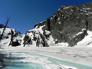
Sawtooth Lake is an alpine lake in Custer County, Idaho, United States, located high in the Sawtooth Mountains in the Sawtooth National Recreation Area. The lake is approximately 6.8 miles (10.9 km) southwest of Stanley. A trail from the Iron Creek trailhead and campground leads approximately 5 miles to Sawtooth Lake. The Iron Creek trailhead can be accessed from State Highway 21 via Sawtooth National Forest road 619.

Castle Peak is a mountain in the western United States, the highest peak in the White Cloud Mountains of central Idaho and the Idaho Batholith. Located in Custer County, it is the 25th highest peak in the state, and the ninth most prominent.
Goat Lake is an alpine lake in Custer County, Idaho, United States, located high in the Sawtooth Mountains in the Sawtooth National Recreation Area. The lake is approximately 6 miles (9.7 km) southwest of Stanley. The lake is most easily accessed from the Iron Creek trailhead, which can be accessed from State Highway 21 via Sawtooth National Forest road 619.

Alpine Lake is an alpine lake in Custer County, Idaho, United States, located high in the Sawtooth Mountains in the Sawtooth National Recreation Area. The lake is approximately 6.3 mi (10.1 km) southwest of Stanley. A trail from the Iron Creek trailhead and campground leads approximately 5 miles (8.0 km) to Sawtooth Lake. The Iron Creek trailhead can be accessed from State Highway 21 via Sawtooth National Forest road 619. There is another lake with the name Alpine Lake in the central part of the Sawtooth Wilderness.

Alpine Lake is an alpine lake in Custer County, Idaho, United States, located high in the Sawtooth Mountains in the Sawtooth National Recreation Area. The lake is approximately 11.4 miles (18.3 km) southwest of Stanley.
Ardeth Lake is an alpine lake in Boise County, Idaho, United States, located high in the Sawtooth Mountains in the Sawtooth National Recreation Area. The lake is approximately 18 miles (29 km) south of Stanley. Ardeth Lake is most easily accessed from trailheads in the Sawtooth Valley, which are accessed from State Highway 75 or from the Grandjean trailhead to the northwest off of State Highway 21.
Edith Lake is a small alpine lake in Custer County, Idaho, United States, located high in the Sawtooth Mountains in the Sawtooth National Recreation Area. The lake is approximately 16.5 miles (26.6 km) south of Stanley. A trail from the Yellow Belly Lake and Pettit Lake trailheads leads towards Edith Lake via Farley Lake. These trailheads can be accessed from State Highway 75 via Sawtooth National Forest road 208.

Pettit Lake is a large alpine lake in Blaine County, Idaho, United States, located in the Sawtooth Valley in the Sawtooth National Recreation Area. The lake is approximately 16 miles (26 km) south of Stanley and 33 miles (53 km) northwest of Ketchum.

Hell Roaring Lake is an alpine lake in Custer County, Idaho, United States, located in the Sawtooth Mountains in the Sawtooth National Recreation Area. The lake is approximately 13.3 miles (21.4 km) southwest of Stanley. The lake can be accessed from State Highway 75 in the Sawtooth Valley. There is a trailhead about two miles from the lake on Sawtooth National Forest road 097, which is a high clearance road. There is another trailhead about two miles further downstream along forest road 210 for those who cannot drive road 097 as well as horses.
Lower Hanson Lake is an alpine lake in Custer County, Idaho, United States, located in the Sawtooth Mountains in the Sawtooth National Recreation Area. The lake is approximately 8.7 miles (14.0 km) west of Stanley. Lower Hanson Lake is accessed via Sawtooth National Forest trail 640 from the Stanley Lake trailhead on forest service road 455 from State Highway 21.
Middle Hanson Lake is an alpine lake in Custer County, Idaho, United States, located in the Sawtooth Mountains in the Sawtooth National Recreation Area. The lake is approximately 8.7 miles (14.0 km) west of Stanley. Middle Hanson Lake is accessed via Sawtooth National Forest trail 640 from the Stanley Lake trailhead on forest service road 455 from State Highway 21.
Upper Hanson Lake is an alpine lake in Custer County, Idaho, United States, located in the Sawtooth Mountains in the Sawtooth National Recreation Area. The lake is approximately 8.7 miles (14.0 km) west of Stanley. Upper Hanson Lake is accessed via Sawtooth National Forest trail 640 from the Stanley Lake trailhead on forest service road 455 from State Highway 21.

Merriam Peak, at 10,920 feet (3,330 m) is one of the peaks of the White Cloud Mountains of Custer County, Idaho. It was named for John H. Merriam who played an instrumental role in protecting the area from being mined for molybdenum. Merriam Peak is located in the middle of the range just north of Castle Peak, the highest point in the range. The peak is located in the White Clouds roadless area of Sawtooth National Recreation Area.

The Sawtooth Valley is a valley in the Western United States, in Blaine and Custer counties in central Idaho, United States.


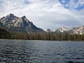 Stanley Lake
 Mountains Behind Stanley Lake
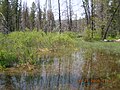 Wetlands Behind Stanley Lake

