Idaho State Highway 21

Last updated

Idaho 21.svg

State Highway 21

Idaho State Highway 21
SH-21 highlighted in red
Route information
Maintained by ITD
Length130.869 mi [1]  (210.613 km)
Tourist
routes
MUTCD D6-4.svg Ponderosa Pine Scenic Byway
Major junctions
South endI-84.svgUS 20.svgUS 26.svgUS 30.svg I-84  / US 20  / US 26  / US 30 in Boise
North endIdaho 75.svg SH-75 in Stanley
Location
Country United States
State Idaho
Counties Ada, Boise, Custer
Highway system
  • Idaho State Highway System
Idaho 19.svg SH-19 Idaho 22.svg SH-22

State Highway 21 (SH-21), also known as the Ponderosa Pine Scenic Byway, [2] is a state highway in Idaho. It runs from Boise to Stanley, primarily as a two-lane road. With two-thirds of its length in Boise County, it passes by historic Idaho City and the village of Lowman to the western edge of the Sawtooth Mountains, then along their northern boundary to Stanley.
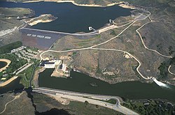
Contents

The road is designated as one of Idaho's scenic byways and provides access to Sawtooth National Recreation Area from Boise and the Treasure Valley. It primarily follows the Boise River and its tributary Mores Creek to the Boise Basin and beyond, and then the upper South Fork of the Payette River and a tributary from Lowman to Banner Creek Summit.

Route description

Lucky Peak Dam near Boise USACE Lucky Peak Dam Idaho.jpg
Lucky Peak Dam near Boise
McGown Peak & Stanley Lake Stanley Lake.JPG
McGown Peak & Stanley Lake
Northern terminus of SH-21 at Stanley Stanley ID - aerial.jpg
Northern terminus of SH-21 at Stanley

SH-21 begins at exit 57 of Interstate 84 southeast of Boise, exactly 3,000 feet (910 m) above sea level. The highway is an eastern extension of Gowen Road, which runs along the southern and western perimeter of the Boise Airport (and the Air National Guard's Gowen Field) to connect with Orchard Road at exit 52 of I-84.[ citation needed ]

After three miles (5 km) eastbound from I-84, Highway 21 descends and crosses the New York Canal and Boise River on a bridge constructed in 1996, [3] and connects with Warm Springs Avenue, old SH-21, from east Boise. The highway heads upstream, briefly as a four-lane divided highway, along the north bank of the river in a basalt canyon. The route passes the century-old Boise River Diversion Dam (1909), and several miles later the Lucky Peak Dam, completed in 1955.[ citation needed ]

Above the Lucky Peak Dam, SH-21 climbs over the Highland Valley Summit (3,782 ft (1,153 m)), then descends to just above the reservoir. It then crosses the Mores Creek tributary and ascends with it to the Boise Basin gold mining area centered around Idaho City, leaving the sagebrush to enter the Ponderosa pine forest of the Boise National Forest. After Idaho City, the highway continues to climb with Mores Creek for another 13 miles (21 km) to the Mores Creek Summit at 6,117 feet (1,864 m), and with Beaver Creek to the Beaver Creek Summit at 6,041 feet (1,841 m)ten miles (16 km) further. Following this summit, SH-21 descends 2,240 feet (683 m) in switchbacks to the village of Lowman at 3,801 feet (1,159 m) above sea level.[ citation needed ]

At Lowman is the intersection with the Wildlife Canyon Scenic Byway, [4] which descends with the South Fork of the Payette River through a canyon popular for whitewater rafting, westward to Banks at Highway 55. A devastating wildfire ravaged the area around Lowman in 1989; it destroyed 45,000 acres (70 sq mi; 180 km2) and 26 structures, but without injuries or fatalities. [5] [6]

North of Lowman, SH-21 ascends the South Fork of the Payette River to Grandjean, on the west side of the Sawtooths, and climbs the Canyon Creek tributary to the Banner Creek Summit at 7,056 feet (2,151 m), the route's maximum elevation, over 3,200 feet (980 m) above Lowman.[ citation needed ]

At the Banner Creek Summit, SH-21 enters Custer County and the Challis National Forest, and descends northward with Banner Creek and Cape Horn Creek, tributaries of the Middle Fork of the Salmon River. At "Cape Horn" the highway turns southeast to gradually climb with Marsh Creek to the border of the Sawtooth National Recreation Area, where SH-21 enters the drainage of the main Salmon River, and gently descends to Stanley. About four miles (6.5 km) west of Stanley is the turnoff for the three-mile (5 km) spur road to the photogenic Stanley Lake at 6,513 feet (1,985 m), framed by the jagged McGown Peak at 9,860 feet (3,005 m).[ citation needed ]

In Stanley, SH-21 terminates at 6,250 feet (1,905 m) at the junction with SH-75, the Sawtooth Scenic Byway from Galena Summit and Ketchum to the south, originating in Shoshone. [7] North of the intersection in Stanley, Highway 75 becomes the Salmon River Scenic Byway, and continues due north for a mile, then veers east with the twisty main Salmon River as it descends to Clayton, then north towards Challis, where the route terminates and rejoins US-93 just south of the city limits. [8]

The upper elevations of SH-21 are often closed during the winter months.[ citation needed ]

History

Portions of the highway originated in the 1860s, as a toll road connecting Boise with the gold mining areas near Idaho City. [9]

SH-21 originally terminated in Downtown Boise by following Warm Springs Avenue along the north side of the Boise River. The state government approved a realignment that truncated the highway at the Gowen Road interchange on I-84 in 1980. [10] A temporary routing was used while a new four-lane highway between the freeway and SH-21 near Lucky Peak Dam was planned in the 1980s. [11] [12] The realigned SH-21 would also serve an expanded Micron Technology facility and residential development on land owned by the J.R. Simplot Company. [13] The new bridge over the Boise River began construction in March 1995 and was opened the following year. [14] [ citation needed ] The former alignment was transferred to the Ada County Highway District on February 1, 1997. [15]

Major intersections

CountyLocationmi [1] kmDestinationsNotes
Ada Boise 0.000.00I-84.svg I-84 (US 20  / US 26  / US 30) Boise, Twin Falls, Mountain Home Southern terminus; I-84 exit 57; road continues west as Gowen Road
Boise Lowman 72.61116.85Wildlife Canyon Scenic Byway (Banks-Lowman Road) – Garden Valley, Banks Elevation 3,800 ft (1,160 m) [4]
Custer Stanley 130.87210.61Idaho 75.svg SH-75  Lower Stanley, Salmon, Sun Valley Northern terminus; SH-75 north is the Salmon River Scenic Byway, [8] SH-75 south is the Sawtooth Scenic Byway [7]
1.000 mi = 1.609 km; 1.000 km = 0.621 mi

See also

Related Research Articles

<span class="mw-page-title-main">Boise County, Idaho</span> County in Idaho, United States

Boise County is a rural mountain county in the U.S. state of Idaho. As of the 2020 United States Census, the population was 7,610. The county seat is historic Idaho City, which is connected through a series of paved and unpaved roads to Lowman, Centerville, Placerville, Pioneerville, Star Ranch, Crouch, Garden Valley, and Horseshoe Bend.

<span class="mw-page-title-main">Horseshoe Bend, Idaho</span> City in Idaho, United States

Horseshoe Bend is the largest city in rural Boise County, in the southwestern part of the U.S. state of Idaho. Its population of 707 at the 2010 census was the largest in the county, though down from 770 in 2000.

<span class="mw-page-title-main">Stanley, Idaho</span> Town in Idaho, United States

Stanley is a town in the Sawtooth Valley in Custer County, Idaho, United States. The population was 116 at the 2020 census; up from 63 in 2010. The center of population of Idaho in 2000 was located in Stanley.

<span class="mw-page-title-main">Galena Summit</span>

Galena Summit is a high mountain pass in the western United States in central Idaho, at an elevation of 8,701 feet (2,652 m) above sea level. The pass is located in the Boulder Mountains, in the northwest corner of Blaine County, within the Sawtooth National Recreation Area of the Sawtooth National Forest.

<span class="mw-page-title-main">Salmon River (Idaho)</span> River in Idaho, United States

The Salmon River, also known as "The River of No Return", is a river located in the U.S. state of Idaho in the western United States. It flows for 425 miles (685 km) through central Idaho, draining a rugged, thinly populated watershed of 14,000 square miles (36,000 km2). The river drops more than 7,000 feet (2,100 m) from its headwaters, near Galena Summit above the Sawtooth Valley in the Sawtooth National Recreation Area, to its confluence with the Snake River. Measured at White Bird, its average discharge is 11,060 cubic feet per second. The Salmon River is the longest undammed river in the contiguous United States and the longest within a single state outside Alaska.

<span class="mw-page-title-main">Boise River</span> River in Idaho, United States

The Boise River is a 102-mile-long (164 km) tributary of the Snake River in the Northwestern United States. It drains a rugged portion of the Sawtooth Range in southwestern Idaho northeast of Boise, as well as part of the western Snake River Plain. The watershed encompasses approximately 4,100 square miles (11,000 km2) of highly diverse habitats, including alpine canyons, forest, rangeland, agricultural lands, and urban areas.

<span class="mw-page-title-main">Payette River</span> River in Idaho

The Payette River is an 82.7-mile-long (133.1 km) river in southwestern Idaho and is a major tributary of the Snake River.

<span class="mw-page-title-main">Boise National Forest</span> National forest in the US state of Idaho

Boise National Forest is a National Forest covering 2,203,703 acres (8,918.07 km2) of the U.S. state of Idaho. Created on July 1, 1908, from part of Sawtooth National Forest, it is managed by the U.S. Forest Service as five units: the Cascade, Emmett, Idaho City, Lowman, and Mountain Home ranger districts.

Lowman is a small unincorporated rural census-designated place in the western United States, located in Boise County, Idaho. It is nestled along the north bank of the South Fork of the Payette River in the central part of the state, at an elevation of 3,800 feet (1,160 m) above sea level. As of the 2010 census, its population was 42.

<span class="mw-page-title-main">Idaho State Highway 55</span> State highway in Idaho, United States

State Highway 55 (SH-55) is an Idaho highway from Marsing to New Meadows, connecting with US-95 at both ends.

<span class="mw-page-title-main">U.S. Route 93 in Idaho</span> Section of U.S. Highway in Idaho, United States

U.S. Route 93 (US-93) is a north–south U.S. Highway in the U.S. state of Idaho.

<span class="mw-page-title-main">Idaho State Highway 75</span> State highway in Lincoln, Blaine, and Custer Counties in Idaho, United States

State Highway 75 is a two-lane highway in the western United States that travels through the Sawtooth Valley of central Idaho. The highway's southern terminus is in Shoshone, and its northern is near Challis. It is designated as one of Idaho's scenic byways and provides access to Sawtooth National Recreation Area and primarily follows the Big Wood River in the south and the main Salmon River in the north, divided by Galena Summit.

Mount Cramer, at 10,716 feet (3,266 m) is the second highest peak in the Sawtooth Range of Idaho. The summit of Mount Cramer is located on the border of Custer and Boise Counties. The peak is the highest point in Boise County. Mount Cramer is also located within the Sawtooth Wilderness portion of the Sawtooth National Recreation Area. The town of Stanley, Idaho is almost 14 miles (23 km) from Mount Cramer, while the area known as Sawtooth City is nearly 12 miles (19 km) from Mount Cramer. The west side of Mount Cramer drains into the South Fork of the Payette River, while the east side drains to the Salmon River.

<span class="mw-page-title-main">White Cloud Mountains</span>

The White Cloud Mountains are part of the Rocky Mountains of the western United States, located in central Idaho, southeast of Stanley in Custer County. The range is located within the Sawtooth National Recreation Area (SNRA) and partially within the Cecil D. Andrus–White Clouds Wilderness.

Mores Creek Summit is a mountain pass in the western United States in southwest Idaho, at an elevation of 6,118 feet (1,865 m) above sea level. Traversed by State Highway 21, the Ponderosa Pine Scenic Byway, it is located in Boise County in the Boise National Forest.

Spring Valley Summit is a mountain pass in the western United States in southwestern Idaho, at an elevation of 4,242 feet (1,293 m) above sea level. North of the city of Boise, it is traversed by State Highway 55, the Payette River Scenic Byway.

Banner Creek Summit is a mountain pass in the western United States in central Idaho, at an elevation of 7,037 feet (2,145 m) above sea level. Traversed by State Highway 21, the Ponderosa Pine Scenic Byway, it is located on the border of Custer County and Boise County, also the border of the Challis and Boise National Forests, immediately northwest of the Sawtooth Range.

<span class="mw-page-title-main">Smiths Ferry, Idaho</span> Census-designated place in Idaho, United States

Smiths Ferry is a census-designated place in Valley County, Idaho, United States. Its population was 75 as of the 2010 census. Situated where the North Fork of the Payette River briefly calms and widens, its elevation is 4,554 feet (1,388 m) above sea level.

<span class="mw-page-title-main">Sawtooth Valley</span>

The Sawtooth Valley is a valley in the Western United States, in Blaine and Custer counties of central Idaho. About 30 miles (50 km) long, it is in Sawtooth National Recreation Area (SNRA) in the Sawtooth National Forest. It is surrounded by the Sawtooth Mountains to the west, White Cloud Mountains to the east, Salmon River Mountains to the north, and Boulder and Smoky Mountains to the south. The valley contains the headwaters of the Salmon River, the city of Stanley, and community of Sawtooth City.

References

  1. 1 2 "State Highway 21 Milepoint Log" (PDF). Idaho Transportation Department. May 15, 2015. Archived from the original (PDF) on March 5, 2016. Retrieved October 24, 2015.
  2. "Ponderosa Pine Scenic Byway". Visit Idaho. Archived from the original on September 6, 2015. Retrieved October 24, 2015.
  3. "SH-21 over Boise River". (Ada County, Idaho): BridgeReports.com. Retrieved March 8, 2020.
  4. 1 2 "Wildlife Canyon Scenic Byway". Visit Idaho. Retrieved October 24, 2015.
  5. "Lowman blaze cleanup to cost $3.6 million". The Spokesman-Review. Associated Press. September 22, 1989. p. B1.
  6. "'Against all the odds,' Lowman forest heals". The Spokesman-Review. Associated Press. July 30, 1990. p. A9.
  7. 1 2 "Sawtooth Scenic Byway". Visit Idaho. Retrieved October 24, 2015.
  8. 1 2 "Salmon River Scenic Byway". Visit Idaho. Retrieved October 24, 2015.
  9. "The Old Toll Road". Historical Marker Database. (Idaho - 266). Retrieved October 24, 2011.
  10. Anderson, Steven (April 11, 1980). "Proposal to alter Idaho 21 OK'd". The Idaho Statesman . p. 2B. Retrieved February 11, 2023 via Newspapers.com.
  11. Funaiole, Linda (March 18, 1981). "Dollar detour: 'Desert' route linking Idaho 21, I-84 may be built in stages". The Idaho Statesman. p. 1C. Retrieved February 11, 2023 via Newspapers.com.
  12. Abe, Debby (April 16, 1984). "Hearing set on Gowen four-lane connector". The Idaho Statesman. p. 1C. Retrieved February 11, 2023 via Newspapers.com.
  13. Bailey, Julie (October 20, 1994). "Micron's risk is beautiful to J.R." The Idaho Statesman. p. 1A. Retrieved February 11, 2023 via Newspapers.com.
  14. Eckart, Kim (May 17, 1995). "Water delays work on bridge". The Idaho Statesman. p. 1B. Retrieved February 11, 2023 via Newspapers.com.
  15. "Regular Meeting of the Idaho Transportation Board, January 21–22, 1997" (PDF). Idaho Transportation Department. January 22, 1997. p. 2. Retrieved February 11, 2023.

Route map:

Template:Attached KML/Idaho State Highway 21
KML is from Wikidata