Downtown Boise

Last updated
Downtown Boise
Boise Downtown Panoramic.jpg
Downtown Boise from the Aspen Lofts
Usa edcp relief location map.png
Red pog.svg
Boise
Location in the United States
USA Idaho relief location map.svg
Red pog.svg
Boise
Location in Idaho
Coordinates: 43°36′54″N116°12′14″W / 43.615°N 116.204°W / 43.615; -116.204
CountryFlag of the United States.svg  United States
StateFlag of Idaho.svg  Idaho
County Ada County
City Boise
Subdistricts of downtown
List
  • BoDo
  • Boise Central Downtown
  • Boise Cultural District
  • Capitol District
  • Linen District
  • Old Boise
  • Pioneer District
Area
  Total1.02 sq mi (2.63 km2)
Highest elevation
2,724 ft (830 m)
Lowest elevation
2,672 ft (814 m)
ZIP codes
83702
Area code 208
Website downtownboise.org

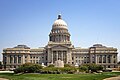
Downtown Boise is the central business district of Boise, Idaho, located north of the Boise River. It is the largest city center in the U.S. state of Idaho.

Contents

Economy

Largest private sector employers

RankEmployerEmployees
1 St. Luke's Health Systems 7,000–7,999
2 Micron Technology 5,000–5,999
3Saint Alphonsus Health System5,000–5,999
4 Albertsons 3,000–3,999
5 Walmart 3,000–3,999
6 Simplot 2,000–2,999
7 HP Inc. 1,000–1,999
8 Fred Meyer 1,000-1,999
9 Idaho Power 1,000–1,999
10 Wells Fargo 1,000–1,999

Parks

Tallest buildings

RankNameImageHeight
ft (m)
FloorsYearCoordinatesNotes
1 Zions Bank Building Zions Bank Building in Boise.jpg -->323 (98)182014 43°36′58.3″N116°12′13.2″W / 43.616194°N 116.203667°W / 43.616194; -116.203667 (8th & Main) Tallest building in Idaho since 2013
2 U.S. Bank Plaza Boise-us-bank-bld.jpg 267 (81)191978 43°36′53.8″N116°12′11.4″W / 43.614944°N 116.203167°W / 43.614944; -116.203167 (U.S. Bank Plaza) Tallest building in Idaho from 1978 to 2013
3 One Capital Center OneCapitalCenterBoise.jpg 206 (63)141975 43°36′58.7″N116°12′20.9″W / 43.616306°N 116.205806°W / 43.616306; -116.205806 (One Capital Center) Tallest building in Idaho from 1975 to 1978
4 Idaho State Capitol Idaho Capitol Building.JPG 206 (63)41920 43°37′3.9″N116°11′59″W / 43.617750°N 116.19972°W / 43.617750; -116.19972 (Idaho State Capitol) Tallest building in Idaho from 1920 to 1975
5Grove Hotel GroveHotelBoise.jpg 196 (60)162000 43°36′50.8″N116°12′14.4″W / 43.614111°N 116.204000°W / 43.614111; -116.204000 (The Grove Hotel)
6The Aspen Lofts AspenLoftsBoise.jpg 194 (59)172009 43°36′50.8″N116°12′21.3″W / 43.614111°N 116.205917°W / 43.614111; -116.205917 (The Aspen Lofts)
7 Wells Fargo Center WellsFargoCenterBoise.jpg 182 (55)111988 43°36′57.2″N116°12′16.6″W / 43.615889°N 116.204611°W / 43.615889; -116.204611 (Wells Fargo Center)
8 Banner Bank Building BannerBankBuildingBoise.jpg 181 (55)112006 43°37′6.1″N116°12′14″W / 43.618361°N 116.20389°W / 43.618361; -116.20389 (Banner Bank Building)
9 Key Center174 (53)131963 43°36′58″N116°12′5.8″W / 43.61611°N 116.201611°W / 43.61611; -116.201611 (Key Center) originally Bank of Idaho Building
10 Hoff Building HoffBuildingBoise.jpg 165 (50)141930 43°37′4″N116°12′7.5″W / 43.61778°N 116.202083°W / 43.61778; -116.202083 (Banner Bank Building) originally Hotel Boise

Transportation

Interstate 184 connects Interstate 84 with downtown. The interstate also carries US 20 and US 26 into downtown, which joins the freeway in Garden City. The freeway ends downtown at 13th Street, where it continues along two five-lane one-way streets. Myrtle Street carries eastbound traffic, while the three center lanes of the westbound Front Street become I-184 westbound. Broadway carries US 20/US 26 south to I-84, where it runs concurrently with the freeway heading east. Downtown is three miles north of the Boise Airport.

Bus service

Greyhound has a bus terminal in downtown Boise at Bannock and Thirteenth Streets. Greyhound operates buses to Salt Lake City and points beyond and to Pendleton, where one can continue on to Portland, Seattle or Spokane. ValleyRide offers numerous bus routes downtown that service the rest of the Boise metropolitan area.

River crossings

See also

Related Research Articles

<span class="mw-page-title-main">Interstate 278</span> Interstate Highway in New Jersey and New York

Interstate 278 (I-278) is an auxiliary Interstate Highway in New Jersey and New York in the United States. The road runs 35.62 miles (57.32 km) from US Route 1/9 (US 1/9) in Linden, New Jersey, northeast to the Bruckner Interchange in the New York City borough of the Bronx. The majority of I-278 is in New York City, where it serves as a partial beltway and passes through all five of the city's boroughs. I-278 follows several freeways, including the Union Freeway in Union County, New Jersey; the Staten Island Expressway (SIE) across Staten Island; the Gowanus Expressway in southern Brooklyn; the Brooklyn–Queens Expressway (BQE) across northern Brooklyn and Queens; a small part of the Grand Central Parkway in Queens; and a part of the Bruckner Expressway in the Bronx. I-278 also crosses multiple bridges, including the Goethals, Verrazzano-Narrows, Kosciuszko, and Robert F. Kennedy bridges.

<span class="mw-page-title-main">Interstate 184</span> Interstate Highway spur in Boise, Idaho, United States

Interstate 184 (I-184) is a short auxiliary Interstate Highway in Boise, Idaho, United States. It is a spur route of I-84 that connects the freeway to Downtown Boise, terminating at US Highway 20 (US 20) and US 26 on the west side of the Boise River.

<span class="mw-page-title-main">Arroyo Seco Parkway</span> Highway in California

The Arroyo Seco Parkway, also known as the Pasadena Freeway, is one of the oldest freeways built in the United States. The parkway connects Los Angeles with Pasadena alongside the Arroyo Seco seasonal river. It is notable not only for being an early freeway, mostly opened in 1940, but for representing the transitional phase between early parkways and later freeways. It conformed to modern standards when it was built, but is now regarded as a narrow, outdated roadway. A 1953 extension brought the south end to the Four Level Interchange in downtown Los Angeles and a connection with the rest of the freeway system.

<span class="mw-page-title-main">Boise greenbelt</span>

The Boise River Greenbelt is a recreational and alternate transportation trail along the banks of the Boise River through Boise, Idaho, United States. The Boise Greenbelt is more of a greenway than a green belt since its character is linear. It extends more than 20 miles (32 km) beginning at Lucky Peak Dam in the east to a short distance beyond Eagle Road in the west in Eagle, Idaho. Taking into account both sides of the river and other parallel trails and spurs, the total Greenbelt trail system measures more than 30 miles (48 km).

<span class="mw-page-title-main">Ross Island Bridge</span> Bridge in Portland, Oregon

The Ross Island Bridge is a cantilever truss bridge that spans the Willamette River in Portland, Oregon. It carries U.S. Route 26 across the river between southwest and southeast Portland. The bridge opened in 1926 and was designed by Gustav Lindenthal and honors Oregon pioneer Sherry Ross. It is named for its proximity to Ross Island. Although it looks like a deck arch bridge, it is a cantilever deck truss bridge, a rare type in Oregon.

<span class="mw-page-title-main">Interstate 676</span> Highway in New Jersey and Pennsylvania

Interstate 676 (I-676) is an Interstate Highway that serves as a major thoroughfare through Center City Philadelphia, where it is known as the Vine Street Expressway, and Camden, New Jersey, where it is known as the northern segment of the North–South Freeway, as well as the Martin Luther King Jr. Memorial Highway in honor of civil rights leader Martin Luther King Jr. Its western terminus is at I-76 in Philadelphia near the Philadelphia Museum of Art and Fairmount Park. From there, it heads east and is then routed on surface streets near Franklin Square and Independence National Historical Park, home of the Liberty Bell, before crossing the Delaware River on the Benjamin Franklin Bridge. On the New Jersey side of the bridge, the highway heads south to its southern terminus at I-76 in Gloucester City near the Walt Whitman Bridge. Between the western terminus and downtown Camden, I-676 is concurrent with U.S. Route 30 (US 30).

<span class="mw-page-title-main">Interstate 84 (Oregon–Utah)</span> Interstate Highway in the U.S. states of Oregon, Idaho, and Utah

Interstate 84 (I-84) is an Interstate Highway in the northwestern United States. The highway runs from Portland, Oregon, to a junction with I-80 near Echo, Utah. The highway serves and connects Portland, Boise, and Ogden, Utah. With connections to other highways, I-84 connects these cities to points east and also serves as part of a corridor between Seattle and Salt Lake City. The sections running through Oregon and Idaho are also known as the Vietnam Veterans Memorial Highway.

<span class="mw-page-title-main">Virginia State Route 195</span> State highway in the City of Richmond, Virginia, US

State Route 195 is a controlled-access toll road in the U.S. state of Virginia. Known as the Downtown Expressway, the state highway runs 3.39 miles (5.46 km) from Interstate 195 (I-195) east to I-95 within the independent city of Richmond. SR 195 connects the West End of Richmond with Downtown Richmond. In conjunction with another toll road, SR 76, the state highway also connects the Southside suburbs of the metropolitan area with downtown. SR 195 has a mainline barrier toll plaza and ramp toll plazas at its interchanges with U.S. Route 1 and US 301 and with US 60, all of which accept E-ZPass. The state highway was constructed in the mid- to late 1970s and is maintained by the Richmond Metropolitan Authority.

<span class="mw-page-title-main">California State Route 275</span> Highway in California

State Route 275 is an unsigned state highway connecting West Sacramento, California and Downtown Sacramento. Since 1996, the highway has been legally defined to be the length of the Tower Bridge crossing the Sacramento River. Prior to that year, SR 275 was also known as the West Sacramento Freeway, and was a short spur connecting Interstate 80 Business / U.S. Route 50 in West Sacramento, and the Tower Bridge. SR 275 also extended east into Sacramento along the Capitol Mall from the bridge to 9th Street, just west of the California State Capitol. West Sacramento completed a project to replace the freeway with a pedestrian-friendly street named Tower Bridge Gateway.

<span class="mw-page-title-main">Interstate 235 (Iowa)</span> Highway in Iowa

Interstate 235 (I-235) in Iowa is an auxiliary Interstate Highway that runs just north of downtown Des Moines through the heart of the Des Moines metropolitan area. I-235 runs from the junction of I-35 and I-80 in West Des Moines to the separation of the same two Interstates in Ankeny. The highway is approximately 14 miles (23 km) long.

<span class="mw-page-title-main">Figueroa Street Tunnels</span> Series of freeway tunnels in Los Angeles, California

The Figueroa Street Tunnels are a set of four four-lane tunnels that carry northbound traffic on State Route 110 through Elysian Park in Los Angeles, California, United States. From south to north, the four tunnels measure 755, 461, 130, and 405 feet in length, 46.5 feet in width, and 28.3 ft in height.

<span class="mw-page-title-main">Interstate 95 in Connecticut</span> Highway in Connecticut

Interstate 95 (I-95) is the main north–south Interstate Highway on the East Coast of the United States, running in a general east–west compass direction for 111.57 miles (179.55 km) in Connecticut, from the New York state line to the Rhode Island state line. I-95 from Greenwich to East Lyme is part of the Connecticut Turnpike, during which it passes through the major cities of Stamford, Bridgeport, and New Haven. After leaving the turnpike in East Lyme, I-95 is known as the Jewish War Veterans Memorial Highway and passes through New London, Groton, and Mystic, before exiting the state through North Stonington at the Rhode Island border.

<span class="mw-page-title-main">Founders Bridge</span> Bridge in Hartford, Connecticut

The Founders Bridge is one of the three highway bridges over the Connecticut River in Hartford, Connecticut. The steel stringer bridge carries the Route 2 expressway, and also crosses over Interstate 91. As of 2013 the bridge had an average daily traffic of 29,200.

<span class="mw-page-title-main">Interstate 95 in Maryland</span> Interstate Highway in Maryland

Interstate 95 (I-95) is an Interstate Highway running along the East Coast of the United States from Miami, Florida, north to the Canada–United States border at Houlton, Maine. In Maryland, the route is a major highway that runs 110.01 miles (177.04 km) diagonally from southwest to northeast, entering from the District of Columbia and Virginia at the Woodrow Wilson Bridge over the Potomac River, northeast to Maryland's border with Delaware near Elkton. It is the longest Interstate Highway within Maryland and is one of the most traveled Interstate Highways in the state, especially between Baltimore and Washington, D.C., despite alternate routes along the corridor, such as the Baltimore–Washington Parkway, U.S. Route 1 (US 1), and US 29. I-95 also has eight auxiliary routes in the state, the most of any state along the I-95 corridor. Portions of the highway, including the Fort McHenry Tunnel and the Millard E. Tydings Memorial Bridge, are tolled.

<span class="mw-page-title-main">Interstate 5 in Oregon</span> Interstate highway in Oregon

Interstate 5 (I-5) in the U.S. state of Oregon is a major Interstate Highway that traverses the state from north to south. It travels to the west of the Cascade Mountains, connecting Portland to Salem, Eugene, Medford, and other major cities in the Willamette Valley and across the northern Siskiyou Mountains. The highway runs 308 miles (496 km) from the California state line near Ashland to the Washington state line in northern Portland, forming the central part of Interstate 5's route between Mexico and Canada.

<span class="mw-page-title-main">Interstate 84 in Idaho</span> Highway in Idaho

Interstate 84 (I-84) in the U.S. state of Idaho is a major Interstate Highway that traverses the state from the Oregon state line in the northwest to Utah state line in the southeast. It primarily follows the Snake River across a plain that includes the cities of Boise, Mountain Home, and Twin Falls. The highway is one of the busiest in Idaho and is designated as the Vietnam Veterans Memorial Highway.

<span class="mw-page-title-main">Interstate 84 in Oregon</span> Interstate highway in Oregon

Interstate 84 (I-84) in the U.S. state of Oregon is a major Interstate Highway that traverses the state from west to east. It is concurrent with U.S. Route 30 (US 30) for most of its length and runs 376 miles (605 km) from an interchange with I-5 in Portland to the Idaho state line near Ontario. The highway roughly follows the Columbia River and historic Oregon Trail in northeastern Oregon, and is designated as part of Columbia River Highway No. 2 and all of the Old Oregon Trail Highway No. 6; the entire length is also designated as the Vietnam Veterans Memorial Highway. I-84 intersects several of the state's main north–south roads, including US 97, US 197, I-82, and US 395.

<span class="mw-page-title-main">Julia Davis Park</span> Municipal park which also contains museums and attractions in Boise, Idaho, United States

Julia Davis Park is a municipal park in the western United States, located in the downtown region of Boise, Idaho. Created in 1907 with a land donation from Thomas Jefferson Davis, it is the first park in the "String of Pearls", a series of parks along the Boise River operated by the city's Parks and Recreation Department.

<span class="mw-page-title-main">Streets of Albany, New York</span> Streets of Albany, New York

The streets of Albany, New York have had a long history going back almost 400 years. Many of the streets have changed names over the course of time, some have changed names many times. Some streets no longer exist, others have changed course. Some roads existed only on paper. The oldest streets were haphazardly laid out with no overall plan until Simeon De Witt's 1794 street grid plan. The plan had two grids, one west of Eagle Street and the old stockade, and another for the Pastures District south of the old stockade.

<span class="mw-page-title-main">Business routes of Interstate 90</span>

Interstate 90 Business may refer to several business routes of the Interstate Highway System that connects Interstate 90 with the central business district of various cities bypassed by I-90. Each business route can be either a business loop or a business spur, depending on whether both ends connect to I-90. The business route in each community is considered a unique route. In many cases, these routes are a former section of a U.S. Route.

References

  1. "Largest Private Sector Employers in Boise Valley". Boise Valley Economic Partnership. Archived from the original on 2020-10-17. Retrieved 2020-10-10.
  2. Charles Wilkinson Moore
  3. C.W. Moore Park
  4. Homestead Act in Boise Archived June 19, 2013, at the Wayback Machine
  5. Federal Writers' Project. "Idaho: A Guide in Word and Picture." New York: Oxford University Press, 1950.
  6. Rhodes Park
  7. Idaho Transportation Department Archived August 9, 2012, at the Wayback Machine
  8. Boise Greenbelt Guide
  9. Boise River Greenbelt
  10. Ninth Street Bridge
  11. Lusk Street District Project
  12. "Greenbelt map" (PDF). Archived from the original (PDF) on 2013-03-21. Retrieved 2013-10-11.
  13. Memorial Bridge Archived October 12, 2013, at the Wayback Machine
  14. Greenbelt Guide
  15. "Broadway Bridge Replacement Project". Archived from the original on 2013-10-12. Retrieved 2013-10-11.
External videos
Nuvola apps kaboodle.svg A cinéma vérité view of the redevelopment of downtown Boise in 1988