Sublett Range

Last updated
Sublett Range
USA Idaho relief location map.svg
Red triangle with thick white border.svg
Sublett Range
Highest point
Peak Sublett Range High Point
Elevation 7,492 ft (2,284 m)
Coordinates 42°22′12″N112°55′50″W / 42.369989°N 112.93057°W / 42.369989; -112.93057
Dimensions
Length55 mi (89 km)N/S
Width33 mi (53 km)E/W
Area886 sq mi (2,290 km2)
Geography
Country United States
State Idaho

The Sublett Range is a mountain range in the U.S. states of Idaho (~94%) and Utah (~6%), spanning Cassia, Oneida, and Power counties, Idaho and reaching into Box Elder County, Utah. [1] [2] The Phosphoria Formation reaches its greatest thickness beneath the mountains. [3]
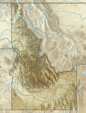
The highest point in the range is known as the Sublett Range High Point at 7,492 feet (2,284 m), and the range is a part of the Basin and Range Province. [4] The northern part of the mountains are part of the Sublett Division of the Minidoka Ranger District of Sawtooth National Forest. [5] The range was named after the trapper William Sublette, who lived in the area in the 1830s. [6]

The Raft River and Black Pine mountains are southwest of the range, while the Albion Mountains are to the west. The northern part of the mountains are in the Snake River watershed, which is a tributary of the Columbia River, while the southern section drains to the Great Salt Lake. The town of Snowville, Utah is south of the mountains, Malta, Idaho is to the west, and American Falls, Idaho is to the north. Interstate 84 passes just to the south and west of the mountains. Most of the mountains are covered in sagebrush steppe and meadows, but there can be pockets of Douglas fir on northern slopes. [5]

Related Research Articles

<span class="mw-page-title-main">Raft River</span> River in Box Elder County, Utah and Cassia County, Idaho in the United States

The Raft River is a 108-mile-long (174 km) tributary of the Snake River located in northern Utah and southern Idaho in the United States. It is part of the Columbia River Basin.

<span class="mw-page-title-main">Sawtooth Wilderness</span> Wilderness area in the state of Idaho

The Sawtooth Wilderness is a federally-protected wilderness area that covers 217,088 acres (87,852 ha) of the state of Idaho. Managed by the U.S. Forest Service in the U.S. Department of Agriculture, it was designated the Sawtooth Primitive Area in 1937 to preserve the scenic beauty of the Sawtooth Mountains. On August 22, 1972 Public Law 92-400 designated the Primitive Area as the Sawtooth Wilderness and part of the newly created Sawtooth National Recreation Area. As part of the National Wilderness Preservation System, the Sawtooth Wilderness is an area where human development and use are restricted and people are to remain only visitors. According to the United States Environmental Protection Agency, the Sawtooth Wilderness has some of the clearest air in the lower 48 states.

<span class="mw-page-title-main">Sawtooth National Forest</span> National forest located in Idaho and Utah in the United States

Sawtooth National Forest is a National Forest that covers 2,110,408 acres in the U.S. states of Idaho and Utah. Managed by the U.S. Forest Service in the U.S. Department of Agriculture, it was originally named the Sawtooth Forest Reserve in a proclamation issued by President Theodore Roosevelt on May 29, 1905. On August 22, 1972, a portion of the forest was designated as the Sawtooth National Recreation Area (SNRA), which includes the Sawtooth, Cecil D. Andrus–White Clouds, and Hemingway–Boulders wilderness areas. The forest is managed as four units: the SNRA and the Fairfield, Ketchum, and Minidoka Ranger Districts.

<span class="mw-page-title-main">Sawtooth Range (Idaho)</span> Mountain range in Idaho, United States

The Sawtooth Range is a mountain range of the Rocky Mountains in central Idaho, United States, reaching a maximum elevation of 10,751 feet (3,277 m) at the summit of Thompson Peak. It encompasses an area of 678 square miles (1,756 km2) spanning parts of Custer, Boise, Blaine, and Elmore counties, and is bordered to the east by the Sawtooth Valley. Much of the mountain range is within the Sawtooth Wilderness, part of the Sawtooth National Recreation Area and Sawtooth National Forest.

Mount Cramer, at 10,716 feet (3,266 m) is the second highest peak in the Sawtooth Range of Idaho. The summit of Mount Cramer is located on the border of Custer and Boise Counties. The peak is the highest point in Boise County. Mount Cramer is also located within the Sawtooth Wilderness portion of the Sawtooth National Recreation Area. The town of Stanley, Idaho is almost 14 miles (23 km) from Mount Cramer, while the area known as Sawtooth City is nearly 12 miles (19 km) from Mount Cramer. The west side of Mount Cramer drains into the South Fork of the Payette River, while the east side drains to the Salmon River.

<span class="mw-page-title-main">Mount Heyburn</span> Mountain in the state of Idaho

Mount Heyburn, at 10,229 feet (3,118 m) is one of the many 10,000-foot (3,050 m) peaks in the Sawtooth Range of central Idaho. Mount Heyburn is located in Custer County and within the Sawtooth Wilderness portion of the Sawtooth National Recreation Area. The town of Stanley is located eight miles (13 km) north-northeast of Mount Heyburn. Grand Mogul, 9,733 ft (2,967 m), and Mount Heyburn are the two signature peaks that frame the southwest end of Redfish Lake ; all are in the Salmon River watershed.

<span class="mw-page-title-main">White Cloud Mountains</span> Mountain in the state of Idaho

The White Cloud Mountains are part of the Rocky Mountains of the western United States, located in central Idaho, southeast of Stanley in Custer County. The range is located within the Sawtooth National Recreation Area (SNRA) and partially within the Cecil D. Andrus–White Clouds Wilderness.

<span class="mw-page-title-main">Raft River Mountains</span> Mountain range in Utah, United States

The Raft River Mountains are a mountain range in northern Box Elder County, Utah, United States. The mountains are located in the Raft River Division of the Minidoka Ranger District of the Sawtooth National Forest. The highest point is Bull Mountain, near the Dunn Benchmark, at 9,925 ft (3,025 m), and the ghost town of Yost is on the north-central slopes. Tributaries of the Raft River drain the northern slopes of the range to the Snake River then Columbia River and Pacific Ocean, while the southern slopes drain to the Great Salt Lake.

<span class="mw-page-title-main">Soldier Mountains</span> Mountain range in the state of Idaho, US

The Soldier Mountains are a mountain range in the U.S. state of Idaho, spanning northern Camas and eastern Elmore counties. The highest point in the range is Smoky Dome at 10,095 feet (3,077 m), and the range is bounded on the west and north by the South Fork Boise River. The mountains are located within Sawtooth National Forest north of Fairfield, Idaho. The Soldier Mountain Ski Area is located within the range to the east of Smoky Dome.

<span class="mw-page-title-main">Iron Mountain (Idaho)</span> Mountain in the state of Idaho

Iron Mountain, at 9,694 feet (2,955 m) high is one of the peaks of the Soldier Mountains of Idaho. Iron Mountain is located at the west end of the range northwest of Fairfield in Camas County and Sawtooth National Forest.

<span class="mw-page-title-main">Boardman Peak</span> Mountain in the state of Idaho

Boardman Peak, at 9,457 feet (2,882 m) high is one of the peaks of the Soldier Mountains of Idaho. Boardman Peak is located at the center of the range southeast of Iron Mountain, northwest of Smoky Dome, and northwest of Fairfield in Camas County and Sawtooth National Forest. No trails go to the summit, but several pass near the peak, and the ascent is only class 2.

<span class="mw-page-title-main">Bull Mountain (Box Elder County, Utah)</span>

Bull Mountain, an officially unnamed summit in northern Utah, United States, has an elevation of 9,938 feet (3,029 m). It is the highest point in the Raft River Mountains and Box Elder County.

<span class="mw-page-title-main">Albion Mountains</span> Mountain range in Idaho, USA

The Albion Mountains are a mountain range in the U.S. states of Idaho (~99%) and Utah (~1%), spanning Cassia County, Idaho and barely reaching into Box Elder County, Utah. The highest point in the range is Cache Peak at 10,339 feet (3,151 m), and the range is a part of the Basin and Range Province. Most of the mountains are part of the Albion Division of the Minidoka Ranger District of Sawtooth National Forest.

<span class="mw-page-title-main">Cache Peak</span> Mountain in the state of Idaho

Cache Peak, at 10,339 feet (3,151 m) above sea level, is the highest peak in the Albion Mountains of Cassia County in Southern Idaho. Cache Peak is located in the central part of the range southeast of Oakley and north of Almo in the Albion Division of the Minidoka Ranger District of Sawtooth National Forest.

<span class="mw-page-title-main">Black Pine Mountains</span> Mountain range in Idaho and Utah

The Black Pine Mountains are a mountain range in the U.S. states of Idaho (~65%) and Utah (~35%), spanning Cassia County, Idaho and reaching into Box Elder County, Utah. The highest point in the range is known as Black Pine Mountains High Point, sometimes referred to as Black Peak, at 9,395 feet (2,864 m), and the range is a part of the Great Basin Divide and the Basin and Range Province. In Idaho, the mountains are part of the Black Pine Division of the Minidoka Ranger District of Sawtooth National Forest.

Black Pine Mountains High Point, at 9,289 feet (2,831 m) above sea level is the highest peak in the Black Pine Mountains of Cassia County in southern Idaho. The high point is sometimes referred to as "Black Peak" because of a benchmark on the peak that reads "Black".

Sublett Range High Point, at 7,492 feet (2,284 m) above sea level is the highest peak in the Sublett Range of Power County in southern Idaho, USA. It is located in the east-central part of the range north of Snowville, Utah, east of Malta, Idaho, and south of American Falls, Idaho, in the Sublett Division of the Minidoka Ranger District of Sawtooth National Forest.

<span class="mw-page-title-main">Merriam Peak (Idaho)</span> Mountain in the state of Idaho

Merriam Peak, at 10,920 feet (3,330 m) is one of the peaks of the White Cloud Mountains of Custer County, Idaho. It was named for John H. Merriam who played an instrumental role in protecting the area from being mined for molybdenum. Merriam Peak is located in the middle of the range just north of Castle Peak, the highest point in the range. The peak is located in the White Clouds roadless area of Sawtooth National Recreation Area.

<span class="mw-page-title-main">Mount Harrison (Idaho)</span> Mountain in the state of Idaho

Mount Harrison, at 9,265 feet (2,824 m) is a peak in the northern Albion Mountains of Cassia County in southern Idaho. Mount Harrison is located in north of Cache Peak, south of Burley, northeast of Oakley, and west of Malta in the Albion Division of the Minidoka Ranger District of Sawtooth National Forest. Mount Harrison is in the watershed of tributaries of the Snake River, which itself is a tributary of the Columbia River. The peak can be reached via a paved road that runs all the way to its summit. Lake Cleveland is located in the basin north of the peak, and a small unnamed lake is located in the basin southeast of the peak.

<span class="mw-page-title-main">Kent Peak (Boulder Mountains, Idaho)</span> Mountain in the state of Idaho

Kent Peak, at 11,664 feet (3,555 m) above sea level is the second highest peak in the Boulder Mountains of Idaho. Located on the border of Blaine and Custer counties, Kent Peak is about 0.75 miles (1,210 m) south of the range's highest point, Ryan Peak. The peak is also on the border of Sawtooth National Recreation Area and Salmon-Challis National Forest and partially within the Hemingway–Boulders Wilderness. It is the 34th highest peak in Idaho.

References

  1. "Sublett Range". Geographic Names Information System . United States Geological Survey, United States Department of the Interior.
  2. "Sublett Range". PeakBagger. Retrieved 2012-05-10.
  3. Blatt, Harvey and Robert J. Tracy, Petrology, Freeman, 1996, 2nd ed. pp. 345-349 ISBN   0-7167-2438-3
  4. "Sublett Range High Point, Idaho". PeakBagger. Retrieved 2012-05-10.
  5. 1 2 "Sawtooth National Forest". U.S. Forest Service. Retrieved 2012-05-10.
  6. "Southeast Idaho Ranges". Summitpost. Retrieved 2012-05-10.