Pioneer Mountains (Idaho)

Last updated
Pioneer Mountains
Pioneer Mountains Idaho.JPG
Pioneer Mountains from Hyndman Peak
Highest point
Peak Hyndman Peak
Elevation 12,009 ft (3,660 m)
Coordinates 43°45′N114°08′W / 43.75°N 114.13°W / 43.75; -114.13
Dimensions
Length18 mi (29 km)N/S
Width20 mi (32 km)E/W
Geography
USA Idaho relief location map.svg
Red triangle with thick white border.svg
Pioneer Mountains
Usa edcp relief location map.png
Red triangle with thick white border.svg
Pioneer Mountains
Country United States
State Idaho
Parent range Rocky Mountains

The Pioneer Mountains are a mountain range in the U.S. state of Idaho, spanning Blaine, Butte and Custer counties. The range is bounded on the west by the Big Wood River, Trail Creek and Summit Creek, and the North Fork Big Lost River, on the north and east by the East Fork Big Lost River, Left Fork Cherry Creek, Cherry Creek, Dry Fork Creek, Saint Louis Canyon, and Champagne Creek, and on the south by the Snake River Plain. [1] The mountains are located within Sawtooth and Challis National Forests.

Contents

The Pioneer Mountains range was named for the pioneer settlers of the region; many of the individual mountains within the range also bear the name of these pioneers. [2]

Peaks of the Pioneer Mountains

Peaks of the Pioneer Mountains of Idaho [3]
Rank Mountain Peak Elevation Prominence Isolation Location Easiest Route
1 Hyndman Peak 12,008 ft
3660 m
4,806 ft
1465 m
30.2 mi
48.6 km
43°44′58″N114°07′52″W / 43.74936°N 114.131103°W / 43.74936; -114.131103 (HyndmanPeak) Class 2
2 Goat Mountain 11,913 ft
3631 m
814 ft
248 m
1.8 mi
2.9 km
43°46′27″N114°08′31″W / 43.774184°N 114.142059°W / 43.774184; -114.142059 (Goat Mountain) Class 5
3 Peak 11,887 11,886 ft
3623 m
1,526 ft
465 m
5.34 mi
8.6 km
43°46′29″N114°01′49″W / 43.77485°N 114.030224°W / 43.77485; -114.030224 (Peak 11887) Class 3
4 Standhope Peak 11,877 ft
3620 m
466 ft
142 m
0.73 mi
1.17 km
43°47′05″N114°01′30″W / 43.784645°N 114.024879°W / 43.784645; -114.024879 (Standhope Peak) Class 3
5 Devils Bedstead East 11,864 ft
3616 m
495 ft
151 m
1.76 mi
2.83 km
43°47′55″N114°09′08″W / 43.798592°N 114.152313°W / 43.798592; -114.152313 (Devils Bedstead East) Class 3
6 Brocky Peak 11,841 ft
3609 m
761 ft
232 m
1.65 mi
2.65 km
43°45′25″N114°03′07″W / 43.756831°N 114.051867°W / 43.756831; -114.051867 (Brocky Peak) Class 3
7 Altair Peak 11,824 ft
3604 m
784 ft
239 m
1.03 mi
1.65 km
43°47′33″N114°00′27″W / 43.792594°N 114.007596°W / 43.792594; -114.007596 (Altair Peak) Class 3
8 Old Hyndman Peak 11,775 ft
3589 m
935 ft
285 m
0.92 mi
1.48 km
43°44′27″N114°07′02″W / 43.74071°N 114.117141°W / 43.74071; -114.117141 (Old Hyndman Peak) Class 3
9 Duncan's Peak 11,755 ft
3583 m
394 ft
120 m
0.57 mi
0.92 km
43°45′22″N114°08′16″W / 43.756159°N 114.137679°W / 43.756159; -114.137679 (Duncan's Peak) Class 3
10 Pegasus Peak 11,736 ft
3577 m
617 ft
188 m
1.37 mi
2.21 km
43°48′44″N114°00′44″W / 43.812166°N 114.012169°W / 43.812166; -114.012169 (Pegasus Peak) Class 3
11 Angel's Perch 11,686 ft
3562 m
486 ft
148 m
2.29 mi
3.69 km
43°47′50″N114°04′02″W / 43.797248°N 114.067233°W / 43.797248; -114.067233 (Angel's Perch) Class 2
12 Cobb Peak 11,650 ft
3551 m
650 ft
198 m
0.83 mi
1.33 km
43°43′52″N114°07′35″W / 43.731019°N 114.126431°W / 43.731019; -114.126431 (Cobb Peak) Class 3
13 Pyramid Peak 11,627 ft
3544 m
387 ft
118 m
0.84 mi
1.35 km
43°47′47″N113°59′29″W / 43.796297°N 113.991427°W / 43.796297; -113.991427 (Pyramid Peak) Class 2
14 Salzburger Spitzl 11,601 ft
3536 m
322 ft
98 m
0.86 mi
1.39 km
43°46′28″N114°09′33″W / 43.774435°N 114.159269°W / 43.774435; -114.159269 (Salzburger Spitzl) Class 2
X Smiley Mountain 11,509 ft
3508 m
2,628 ft
801 m
7.01 mi
11.28 km
43°41′58″N113°48′36″W / 43.69953°N 113.81013°W / 43.69953; -113.81013 (Smiley Mountain) unknown
X Pioneer Mountain 10,525 ft
3208 m
505 ft
154 m
1.47 mi
2.37 km
43°40′17″N113°54′46″W / 43.67129°N 113.91281°W / 43.67129; -113.91281 (Pioneer Mountain) unknown
X Blizzard Mountain 9,314 ft
2839 m
1,932 ft
589 m
9.27 mi
14.92 km
43°29′53″N113°40′06″W / 43.4981311°N 113.6682246°W / 43.4981311; -113.6682246 (Blizzard Mountain) Class 2

Climate

The Stickney Mill SNOTEL is by the Trail Creek Road, which is on the northern edge of the range.

Climate data for Stickney Mill, Idaho, 1991–2020 normals: 7430ft (2267m)
MonthJanFebMarAprMayJunJulAugSepOctNovDecYear
Average high °F (°C)31.1
(−0.5)
34.0
(1.1)
41.8
(5.4)
47.9
(8.8)
57.1
(13.9)
65.8
(18.8)
76.7
(24.8)
75.5
(24.2)
65.9
(18.8)
51.9
(11.1)
38.1
(3.4)
29.3
(−1.5)
51.3
(10.7)
Daily mean °F (°C)17.2
(−8.2)
19.2
(−7.1)
26.6
(−3.0)
33.8
(1.0)
42.7
(5.9)
49.6
(9.8)
57.6
(14.2)
56.3
(13.5)
48.6
(9.2)
37.6
(3.1)
25.0
(−3.9)
16.3
(−8.7)
35.9
(2.2)
Average low °F (°C)3.3
(−15.9)
4.4
(−15.3)
11.5
(−11.4)
19.6
(−6.9)
28.2
(−2.1)
33.4
(0.8)
38.5
(3.6)
37.2
(2.9)
31.1
(−0.5)
23.1
(−4.9)
12.0
(−11.1)
3.4
(−15.9)
20.5
(−6.4)
Average precipitation inches (mm)1.71
(43)
1.70
(43)
1.93
(49)
1.71
(43)
2.10
(53)
1.80
(46)
0.91
(23)
0.81
(21)
1.20
(30)
1.59
(40)
1.55
(39)
2.09
(53)
19.1
(483)
Source 1: XMACIS2 [4]
Source 2: NOAA (Precipitation) [5]

There is a Remote Automated Weather Station in Copper Basin (Idaho), near the Copper Basin Airport.

Climate data for Copper Basin (RAWS), Idaho, 1991–2020 normals: 7820ft (2384m)
MonthJanFebMarAprMayJunJulAugSepOctNovDecYear
Average high °F (°C)28.9
(−1.7)
32.2
(0.1)
40.2
(4.6)
45.4
(7.4)
54.5
(12.5)
63.4
(17.4)
74.6
(23.7)
73.7
(23.2)
64.5
(18.1)
51.0
(10.6)
38.7
(3.7)
28.8
(−1.8)
49.7
(9.8)
Daily mean °F (°C)13.5
(−10.3)
15.3
(−9.3)
23.2
(−4.9)
31.0
(−0.6)
40.1
(4.5)
46.7
(8.2)
54.2
(12.3)
53.2
(11.8)
45.4
(7.4)
34.5
(1.4)
22.4
(−5.3)
13.1
(−10.5)
32.7
(0.4)
Average low °F (°C)−2.1
(−18.9)
−1.6
(−18.7)
5.5
(−14.7)
15.4
(−9.2)
25.7
(−3.5)
29.9
(−1.2)
33.7
(0.9)
32.6
(0.3)
26.3
(−3.2)
18.0
(−7.8)
6.1
(−14.4)
−2.8
(−19.3)
15.6
(−9.1)
Source: XMACIS2 [6]

Related Research Articles

<span class="mw-page-title-main">Galena Summit</span>

Galena Summit is a high mountain pass in the western United States in central Idaho, at an elevation of 8,701 feet (2,652 m) above sea level. The pass is located in the Boulder Mountains, in the northwest corner of Blaine County, within the Sawtooth National Recreation Area of the Sawtooth National Forest.

<span class="mw-page-title-main">Willow Creek Pass (Colorado)</span>

Willow Creek Pass, elevation 9,683 ft (2,951 m), is a mountain pass that crosses the Continental Divide in the Rocky Mountains of north central Colorado.

<span class="mw-page-title-main">Cloud Peak</span> Mountain in Wyoming, United States

Cloud Peak is the highest peak within the Bighorn Mountains in the U.S. state of Wyoming.

<span class="mw-page-title-main">Bighorn National Forest</span> National forest in Wyoming, United States

The Bighorn National Forest is a U.S. National Forest located in northern Wyoming, United States and consists of over 1.1 million acres (4,500 km2). Created as a US Forest Reserve in 1897, it is one of the oldest government-protected forest lands in the U.S. The forest is well east of the continental divide and extends from the Montana border for a distance of 80 miles (130 km) along the spine of the Bighorn Mountains, an outlying mountain range separated from the rest of the Rocky Mountains by Bighorn Basin. Elevations range from 5,000 feet (1,500 m) along the sagebrush and grass-covered lowlands at the foot of the mountains, to 13,189 feet (4,020 m) on top of Cloud Peak, the highest point in the Bighorn Mountains. Around 99% of the land is above 1,500 metres (4,900 ft). The forest is named after the Bighorn River, which is partially fed by streams found in the forest. Streams in the range are fed primarily by snowmelt and snowmelt mixed with driving rainfall.

<span class="mw-page-title-main">Carson Pass</span> Historic site in Kirkwood, California

Carson Pass is a mountain pass on the crest of the central Sierra Nevada, in the Eldorado National Forest and Alpine County, eastern California.

<span class="mw-page-title-main">Schell Creek Range</span> Mountain in United States of America

The Schell Creek Range is a linear mountain range in central White Pine County, in east-central Nevada. Its length is approximately 132 miles (212 km) in a north-south direction. Most of the range is contained within the Humboldt-Toiyabe National Forest, with some of the range also included in the High Schells Wilderness.

<span class="mw-page-title-main">Independence Mountains</span>

The Independence Mountains are a mountain range in northern Elko County, Nevada, United States. They are called Settoya in Shoshoni. The range reaches a maximum elevation of 10,439 ft (3,182 m) on the summit of McAfee Peak. The range extends northward approximately 70 mi (110 km) from a point near Carlin to the banks of the Owyhee River. To the east is the North Fork of the Humboldt River, and to the west is the Owyhee Desert. Passing to the south is the main branch of the Humboldt River, and near the northern end of the range is the Wild Horse State Recreation Area. The Owyhee River is tributary to the Snake-Columbia system, while the Humboldt is within the Great Basin.

<span class="mw-page-title-main">Mount Sunapee</span>

Mount Sunapee is a 5-mile-long (8.0 km) mountain ridge in the towns of Newbury and Goshen in western New Hampshire, United States. Its highest peak, at the north end of the mountain, is 2,726 feet (831 m) above sea level. The mountain has three secondary peaks, White Ledges at 2,716 ft (828 m); North Peak at 2,280 ft (695 m); and South Peak at 2,608 ft (795 m). The north end of the mountain, including the summit, is within Mount Sunapee State Park, which encompasses 3.85 square miles (10.0 km2) and is home to the popular Mount Sunapee Resort. The mountain extends south to Pillsbury State Park in the towns of Goshen and Washington.

<span class="mw-page-title-main">Tushar Mountains</span> Mountain range in Utah, United States

The Tushar Mountains are the third-highest mountain range in Utah after the Uinta Mountains and the La Sal Range. Located in the Fishlake National Forest, Delano Peak, 12,174 ft  NAVD 88, is the highest point in both Beaver and Piute counties and has a prominence of 4,689 ft. Delano Peak is named for Columbus Delano (1809–1896), Secretary of the Interior, during the Grant administration. The Tushars receive an ample amount of snow annually even though they are situated within the rainshadow of the Sierra Nevada range in California and the Snake Range located in Nevada.

<span class="mw-page-title-main">Geography of Idaho</span> Overview of the Geograpny of Idaho

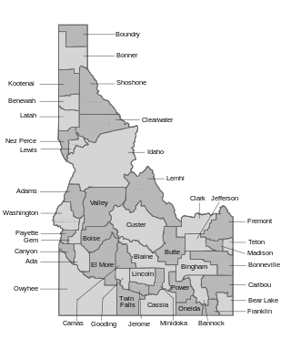
The U.S. state of Idaho borders six other U.S. states and one Canadian province. The states of Washington and Oregon are to the west, Nevada and Utah are to the south, and Montana and Wyoming are to the east. Idaho also shares a short border with the Canadian province of British Columbia to the north.

<span class="mw-page-title-main">Mokelumne Wilderness</span> Protected wilderness area in California, United States

The Mokelumne Wilderness is a 105,165-acre federally designated wilderness area located 70 miles (110 km) east of Sacramento, California. It is within the boundaries of three national forests: Stanislaus, Eldorado and Toiyabe. First protected under the Wilderness Act of 1964, the Mokelumne's borders were expanded under the California Wilderness Act of 1984 with the addition of 55,000 acres. The wilderness takes its name from the Mokelumne River, which was named after a Mi-wok Indian village located on the riverbank in California's Central Valley.

Banner Creek Summit is a mountain pass in the western United States in central Idaho, at an elevation of 7,037 feet (2,145 m) above sea level. Traversed by State Highway 21, the Ponderosa Pine Scenic Byway, it is located on the border of Custer County and Boise County, also the border of the Challis and Boise National Forests, immediately northwest of the Sawtooth Range.

<span class="mw-page-title-main">Whitefish Range</span>

The Whitefish Range is a mountain range stretching north-south from British Columbia, Canada to Montana, United States. It is about 76 miles (122 km) long and 58 miles (93 km) wide. Water flowing from its east side drains down the North Fork Flathead River and its west side drains into the Whitefish River, both part of the Columbia River drainage basin.

<span class="mw-page-title-main">Beaverhead Mountains</span> Mountain range in the U.S. states of Montana and Idaho

The Beaverhead Mountains, highest point Scott Peak, el. 11,393 feet (3,473 m), are a mountain range straddling the Continental Divide in the U.S. states of Montana and Idaho. They are a sub-range of the Bitterroot Range, and divide Beaverhead County, Montana from Lemhi County, Idaho and Clark County, Idaho.

<span class="mw-page-title-main">Smoky Dome</span> Mountain in the state of Idaho

Smoky Dome, at 10,095 feet (3,077 m) above sea level is the highest peak in the Soldier Mountains of Idaho. Smoky Dome is located northwest of Fairfield in Camas County and Sawtooth National Forest.

<span class="mw-page-title-main">Boardman Peak</span> Mountain in the state of Idaho

Boardman Peak, at 9,457 feet (2,882 m) high is one of the peaks of the Soldier Mountains of Idaho. Boardman Peak is located at the center of the range southeast of Iron Mountain, northwest of Smoky Dome, and northwest of Fairfield in Camas County and Sawtooth National Forest. No trails go to the summit, but several pass near the peak, and the ascent is only class 2.

<span class="mw-page-title-main">Lemhi Range</span> Mountain range

The Lemhi Range is a mountain range in the U.S. state of Idaho, spanning the eastern part of the state between the Lost River Range and the Beaverhead Mountains. The highest point in the range is Diamond Peak at 12,202 feet (3,719 m), the third highest peak in Idaho. The range is located within Salmon-Challis and Caribou-Targhee National Forests.

<span class="mw-page-title-main">Altair Peak</span>

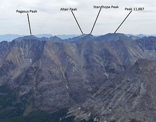
Altair Peak, at 11,825 feet (3,604 m) above sea level is the seventh highest peak in the Pioneer Mountains of Idaho, United States. The peak is located in Salmon-Challis National Forest and Custer County. It is the 25th highest peak in Idaho and about 1 mi (1.6 km) northeast of Standhope Peak and 0.85 mi (1.37 km) southwest of Pyramid Peak.

South River Peak, elevation 13,154 ft (4,009 m), is a summit in the San Juan Mountains of southwestern Colorado, United States. The mountain is in the Weminuche Wilderness of Rio Grande National Forest.

<span class="mw-page-title-main">Hope Valley (California)</span> Mountain valley in Alpine County, California

References

Map all coordinates using: OpenStreetMap
  1. U.S. Geological Survey Geographic Names Information System: Pioneer Mountains
  2. Biennial Report of the Board of Trustees of the State Historical Society of Idaho. Idaho State Historical Society. 1922. p. 21.
  3. "Pioneer Mountains". PeakBagger. Retrieved 2008-09-01.
  4. "xmACIS2". National Oceanic and Atmospheric Administration. Retrieved October 18, 2023.
  5. "Stickney Mill, Idaho 1991-2020 Monthly Normals" . Retrieved October 18, 2023.
  6. "xmACIS2". National Oceanic and Atmospheric Administration. Retrieved November 23, 2023.