
Goat Mountain, at 11,913 feet (3,631 m) above sea level is the second highest peak in the Pioneer Mountains of Idaho. The peak is located on the border of Sawtooth and Salmon-Challis National Forests as well as Blaine and Custer counties. It is the 16th highest peak in Idaho and less than 2 mi (3.2 km) north-northwest of Hyndman Peak.
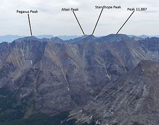
Standhope Peak, at 11,878 feet (3,620 m) above sea level is the fourth highest peak in the Pioneer Mountains of Idaho. The peak is located in Salmon-Challis National Forest and Custer County. It is the 20th highest peak in Idaho and about 0.75 mi (1.21 km) northeast of Peak 11,887 and 1 mi (1.6 km) southwest of Altair Peak.
Devil's Bedstead East, at 11,865 feet (3,616 m) above sea level is the fifth-highest peak in the Pioneer Mountains of the U.S. state of Idaho. The peak is located Salmon-Challis National Forest in Custer County about 1.5 miles north of the Blaine County border and 1.75 miles north-northeast of Goat Mountain. It is the 21st-highest peak in Idaho.

Brocky Peak, at 11,839 feet (3,609 m) above sea level is the sixth highest peak in the Pioneer Mountains of Idaho. The peak is located on the border of Sawtooth and Salmon-Challis National Forests as well as Blaine and Custer counties. It is the 23rd highest peak in Idaho.

Old Hyndman Peak, at 11,775 feet (3,589 m) above sea level, is the eighth-highest peak in the Pioneer Mountains of the U.S. state of Idaho. The peak is located on the border of Sawtooth and Salmon-Challis National Forests as well as Blaine and Custer counties. It is the 27th-highest peak in Idaho and about 0.9 mi (1.4 km) southeast of Hyndman Peak and 0.8 mi (1.3 km) northeast of Cobb Peak.

Duncan's Peak, at 11,755 feet (3,583 m) above sea level, is the ninth-highest peak in the Pioneer Mountains of the U.S. state of Idaho. The peak is located on the border of Sawtooth and Salmon-Challis National Forests as well as Blaine and Custer counties. It is the 28th-highest peak in Idaho and about 0.6 miles (0.97 km) northwest of Hyndman Peak.

Angel's Perch, at 11,687 feet (3,562 m) above sea level is the 11th highest peak in the Pioneer Mountains of Idaho. The peak is located in Salmon-Challis National Forest and Custer County. It is the 32nd highest peak in Idaho and less than 2.3 mi (3.7 km) northwest of Standhope Peak.
Cobb Peak, at 11,650 feet (3,550 m) above sea level is the 12th highest peak in the Pioneer Mountains of Idaho. The peak is located in Sawtooth National Forest and Blaine County. It is the 35th highest peak in Idaho. Cobb Peak is 1.3 mi (2.1 km) south of Hyndman Peak and 0.8 mi (1.3 km) southwest of Old Hyndman Peak.
Pyramid Peak, at 11,628 feet (3,544 m) above sea level is the 13th highest peak in the Pioneer Mountains of Idaho. The peak is located in Salmon-Challis National Forest and Custer County. It is the 36th highest peak in Idaho and about 0.85 mi (1.37 km) northeast of Altair Peak.
Salzburger Spitzl, at 11,600 feet (3,500 m) above sea level is the 14th highest peak in the Pioneer Mountains of Idaho. The peak is located on the border of Sawtooth and Salmon-Challis National Forests as well as Blaine and Custer counties. It is the 40th highest peak in Idaho and less than 0.9 mi (1.4 km) west of Goat Mountain.
Mount Independence is the second highest peak in the Albion Mountains of Idaho. The peak is located in Sawtooth National Forest and Cassia County. It is located about 1 mi (1.6 km) northwest of Cache Peak. The Independence Lakes are located in the basin to the east of the peak. Mount Independence supports one of the three populations of Cymopterus davisii, a plant that is endemic to the Albion Mountains. The Mount Independence population is considered a single population with Cache Peak. Mount Independence is 9,950 feet (3,030 m) above sea level.
Graham Peak is the fourth highest peak in the Albion Mountains of Idaho, at 8,867 feet (2,703 m) above sea level. The peak is located in the City of Rocks National Reserve and Cassia County less than 0.2 mi (0.32 km) south of the Sawtooth National Forest border. It is located 5.13 mi (8.26 km) south-southwest of Cache Peak. Forest road 707 leads directly to the summit. The peak contains the smallest of the three known populations of Cymopterus davisii, estimated at 500–1000 individuals.

Mickey's Spire, at 10,680 feet (3,260 m) above sea level is the fourth highest peak in the Sawtooth Range of Idaho. The peak is located in the Sawtooth Wilderness of Sawtooth National Recreation Area in Custer County. The peak is located 0.24 mi (0.39 km) south-southwest of Thompson Peak, its line parent. It is the 206th highest peak in Idaho.

Snowyside Peak, at 10,651 feet (3,246 m) above sea level, is the fifth-highest peak in the Sawtooth Range of the U.S. state of Idaho. The peak is located in the Sawtooth Wilderness of Sawtooth National Recreation Area at the intersection of Blaine, Custer County, and Elmore counties. It is the highest point in Elmore County. The peak is located 5.1 miles (8.2 km) south of Mount Cramer, its line parent. It is the 217th-highest peak in Idaho.

Mount Carter, at 10,590 feet (3,230 m) above sea level is the seventh highest peak in the Sawtooth Range of Idaho. The peak is located in the Sawtooth Wilderness of Sawtooth National Recreation Area on the border of Boise and Custer counties. The peak is located 0.32 mi (0.51 km) northwest of Mickey's Spire, its line parent, and 0.43 mi (0.69 km) west of Thompson Peak, the highest point in the range.

Mount Limbert, at 10,385 feet (3,165 m) above sea level is the 12th highest peak in the Sawtooth Range of Idaho. The peak is located in the Sawtooth Wilderness of Sawtooth National Recreation Area on the border of Boise and Custer counties. The peak is located 0.54 mi (0.87 km) southwest of Mount Carter, its line parent.

Elk Peak, at 10,582 feet (3,225 m) above sea level, is the eighth-highest peak in the Sawtooth Range of the U.S. state of Idaho. The peak is located in the Sawtooth Wilderness of Sawtooth National Recreation Area in Boise and Custer counties. The peak is located 2.88 mi (4.63 km) west-northwest of Mount Cramer, its line parent. It is the 240th-highest peak in Idaho and 0.5 mi (0.80 km) south-southeast of Reward Peak.
Horstmann Peak, at 10,475 feet (3,193 m) above sea level is the 11th highest peak in the Sawtooth Range of Idaho. The peak is located in the Sawtooth Wilderness of Sawtooth National Recreation Area in Custer County. The peak is located 1.85 mi (2.98 km) south-southeast of Mickey's Spire, its line parent. It is also 2.0 mi (3.2 km) south of Thompson Peak and 1.35 mi (2.17 km) north of Braxon Peak.
Dave's Peak, at 10,579 feet (3,224 m) above sea level is an unofficially named peak that is the ninth highest peak in the Sawtooth Range of Idaho. The peak is located in the Sawtooth Wilderness of Sawtooth National Recreation Area in Custer County. The peak is located 0.65 mi (1.05 km) northeast of Mount Cramer, its line parent. Profile and Lucille lakes are southeast of the peak, while Upper, Middle, and Lower Cramer lakes are northwest of the peak. Dave's Peak is south-southwest of Sevy Peak.

D. O. Lee Peak, also known as Lee Peak, at 11,347 feet (3,459 m) above sea level, is the third-highest peak in the White Cloud Mountains of the U.S. state of Idaho. It is one of the White Cloud Peaks and the 56th-highest peak in Idaho. It was named after Challis native David Oliver Lee (1934–1982), the first United States Forest Service ranger to be assigned to the Sawtooth Wilderness.

