
Boise National Forest is a National Forest covering 2,203,703 acres (8,918.07 km2) of the U.S. state of Idaho. Created on July 1, 1908, from part of Sawtooth National Forest, it is managed by the U.S. Forest Service as five units: the Cascade, Emmett, Idaho City, Lowman, and Mountain Home ranger districts.

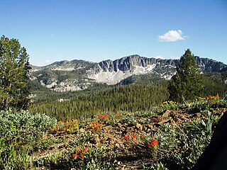
The Sawtooth Range is a mountain range of the Rocky Mountains in central Idaho, United States, reaching a maximum elevation of 10,751 feet (3,277 m) at the summit of Thompson Peak. It encompasses an area of 678 square miles (1,756 km2) spanning parts of Custer, Boise, Blaine, and Elmore counties, and is bordered to the east by the Sawtooth Valley. Much of the mountain range is within the Sawtooth Wilderness, part of the Sawtooth National Recreation Area and Sawtooth National Forest.
Mount Cramer, at 10,716 feet (3,266 m) is the second highest peak in the Sawtooth Range of Idaho. The summit of Mount Cramer is located on the border of Custer and Boise Counties. The peak is the highest point in Boise County. Mount Cramer is also located within the Sawtooth Wilderness portion of the Sawtooth National Recreation Area. The town of Stanley, Idaho is almost 14 miles (23 km) from Mount Cramer, while the area known as Sawtooth City is nearly 12 miles (19 km) from Mount Cramer. The west side of Mount Cramer drains into the South Fork of the Payette River, while the east side drains to the Salmon River.

The North Fork Payette River is a river in western Idaho in the United States. It flows about 113 miles (182 km) southwards from the Salmon River Mountains to near Banks, where it empties into the Payette River, a tributary of the Snake River. It drains a watershed of 912 square miles (2,360 km2), consisting of mountains and forests, and valleys filled with large lakes and wetlands.

Baron Peak, at 10,297 feet (3,139 m) above sea level is a peak in the Sawtooth Range of Idaho. The peak is located in the Sawtooth Wilderness of Sawtooth National Recreation Area on the border of Boise and Custer counties. The peak is located 0.5 mi (0.80 km) southeast of Moolack Mountain, its line parent.

Elk Peak, at 10,582 feet (3,225 m) above sea level, is the eighth-highest peak in the Sawtooth Range of the U.S. state of Idaho. The peak is located in the Sawtooth Wilderness of Sawtooth National Recreation Area in Boise and Custer counties. The peak is located 2.88 mi (4.63 km) west-northwest of Mount Cramer, its line parent. It is the 240th-highest peak in Idaho and 0.5 mi (0.80 km) south-southeast of Reward Peak.
Payette Peak, at 10,221 feet (3,115 m) above sea level is a peak in the Sawtooth Range of Idaho. The peak is located in the Sawtooth Wilderness of Sawtooth National Recreation Area on the border of Boise and Custer counties. The peak is located 1.33 mi (2.14 km) south of Mount Cramer, its line parent. Payette Peak rises above the southwest end of Hidden Lake.
Braxon Peak, at 10,353 feet (3,156 m) above sea level is a peak in the Sawtooth Range of Idaho. The peak is located in the Sawtooth Wilderness of Sawtooth National Recreation Area on the border of Boise and Custer counties. The peak is located 1.36 mi (2.19 km) south of Mount Cramer, its line parent. It is also about 1.2 mi (1.9 km) south-southwest of Mount Heyburn. Braxon Lake is just southwest of the peak.
Packrat Peak, at 10,240 feet (3,120 m) above sea level is a peak in the Sawtooth Range of Idaho. The peak is located in the Sawtooth Wilderness of Sawtooth National Recreation Area on the border of Boise and Custer counties. The peak is located 2.38 mi (3.83 km) north of Elk Peak, its line parent. Warbonnet and Little Warbonnet lakes are in the basin north of the peak.

Mount Regan, rises 10,190 feet (3,110 m) above sea level, and is a peak in the Sawtooth Range of Idaho. The peak is located in the Sawtooth Wilderness of Sawtooth National Recreation Area on the border of Boise and Custer counties. The peak is located 1.9 mi (3.1 km) west of Merritt Peak, its line parent. The peak is named after Timothy Regan, a pioneer who lived in Silver City, and then Boise. Mount Regan is located at the southern end of Sawtooth Lake. The Trailer Lakes and Regan Lake are located northwest of the peak, and the Trail Creek Lakes are west of the peak.
Steel Mountain is the highest point in Boise National Forest and the second highest point in the Boise Mountains at an elevation of 9,730 feet (2,970 m). It is located 17.08 miles (27.49 km) from Two Point Mountain, the highest point in the range and its line parent, giving it a prominence of 2,188 feet (667 m).
Two Point Mountain is the highest point in the Boise Mountains with a summit elevation of 10,124 feet (3,086 m) located in the Fairfield Ranger District of Sawtooth National Forest, Idaho. It is located 12.67 miles (20.39 km) from Perfect Peak in the Sawtooth Range, its line parent, giving it a prominence of 1,524 feet (465 m). Two Point Mountain is named for having two peaks: its main summit and a second summit about 0.4 miles (0.64 km) to the northwest that rises to an elevation of 10,060 feet (3,070 m). The mountain is within the watershed of the South Fork Boise River where the south side is drained by Bear Creek and the north side by the Ross Fork. No maintained trails lead to either summit.

Trinity Mountain is the highest point in the Trinity Mountains, a subrange of the Boise Mountains in Boise National Forest, Idaho with a summit elevation of 9,451 feet (2,881 m). It is located 11.63 miles (18.72 km) from Steel Mountain, its line parent, giving it a prominence of 2,371 feet (723 m). Trinity Mountain is within the watershed of the South Fork Boise River.
The Boise Mountains are a mountain range in the U.S. state of Idaho, spanning part of Boise and Sawtooth national forests. The highest point in the range is Two Point Mountain at an elevation of 10,124 feet (3,086 m) above sea level.
Snowbank Mountain is the highest point in the West Mountains, in Boise National Forest, Idaho with a summit elevation of 8,320 feet (2,540 m) above sea level. It is located 21.92 miles (35.28 km) from Nick Peak, its line parent, giving it a prominence of 3,080 feet (940 m). The east side of Snowbank Mountain is drained by the North Fork Payette River, while the west side is drained by Squaw Creek, which is also a tributary of the Payette River.

The Deadwood River is a 43.5-mile (70.0 km) tributary of the South Fork Payette River, flowing through Boise National Forest in Valley and Boise counties, Idaho in the United States. It joins the South Fork Payette River about 3 miles (4.8 km) west of Lowman. The source of the Deadwood River is below the Deadwood summit on forest road 579 in the Salmon River Mountains. The Deadwood Dam was completed in 1931 and impounded the river to form Deadwood Reservoir.

Monte Verita is a 10,140-foot elevation (3,091 m) mountain summit located in Boise County, Idaho, United States.
