Blackfoot Mountains

Last updated
Blackfoot Mountains
TaylorMountain BlackfootRange.jpg
Taylor Mountain (Bingham County, Idaho)
Highest point
PeakTaylor Mountain (Bingham County, Idaho)
Elevation 2,220 m (7,280 ft)
Coordinates 43°18′19″N111°55′18″W / 43.30528°N 111.92167°W / 43.30528; -111.92167
Geography
CountryUnited States
Provinces/StatesIdaho
Range coordinates 43°11′N111°50′W / 43.183°N 111.833°W / 43.183; -111.833
Parent range Rocky Mountains

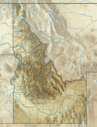
The Blackfoot Mountains, also called the Blackfoot Range, is a small range of mountains located east of Blackfoot, Idaho. Most of the area is private property, including the range's tallest mountain, Taylor Mountain. This mountain was named after Sam Taylor, an early settler of Idaho and brother of Matt Taylor. [1] The Blackfoot River carves through the region. Within this range is Wolverine Canyon, a public area that features sites for hiking, camping, kayaking, rock climbing and other recreational pursuits.
Ecology

Wolverine Canyon is the result of Wolverine Creek eroding the mainly black basalt of the Blackfoot Mountains. WolverineCanyon1 BlackfootMountains Idaho.jpg
Wolverine Canyon is the result of Wolverine Creek eroding the mainly black basalt of the Blackfoot Mountains.
The Blackfoot Mountains as seen from near Iona, Idaho Recent suburban development near Idaho Falls, Idaho.jpg
The Blackfoot Mountains as seen from near Iona, Idaho

This area is mainly a hilly shrub-steppe, covered in sagebrush and juniper. However, there are many springs and small streams which form microclimates with more water-loving plants. The mountains themselves are mainly basalt.

Related Research Articles

<span class="mw-page-title-main">Bonneville County, Idaho</span> County in Idaho, United States

Bonneville County is a county located in the U.S. state of Idaho. As of the 2020 census, the county had a population of 123,964, making it the fourth-most populous county in Idaho and the most populous in eastern Idaho. Its county seat and largest city is Idaho Falls. Bonneville County was established in 1911 and named after Benjamin Bonneville (1796–1878), a French-born officer in the U.S. Army, fur trapper, and explorer in the American West. Benjamin was the son of Nicholas Bonneville of France, an Illuminati member who had written the "Illuminati Manifesto for World Revolution" in 1792, which played a significant role in the French revolution. Bonneville County is part of the Idaho Falls Metropolitan Statistical Area.

<span class="mw-page-title-main">Scouting in Idaho</span>

Scouting in Idaho has a long history, from the 1910s to the present day, serving thousands of youth in programs that suit the environment in which they live.

<span class="mw-page-title-main">Blackfoot, Idaho</span> City in Idaho, United States

Blackfoot is a city in Bingham County, Idaho, United States. The population was 12,355 at the time of the 2020 census. The city is the county seat of Bingham County. Blackfoot is the principal city of the Blackfoot, Idaho, Micropolitan Statistical Area, which includes Bingham County.

<span class="mw-page-title-main">Idaho Falls, Idaho</span> City in Idaho, United States

Idaho Falls is the 4th most populous city in Idaho and the county seat of Bonneville County. It is the state's most populous city outside the Boise metropolitan area. As of the 2020 census, the population of Idaho Falls was 64,818. In the 2010 census, the population of Idaho Falls was 56,813, with a metro population of 133,265.

<span class="mw-page-title-main">Arco, Idaho</span> City in Idaho, United States

Arco is a city in Butte County, Idaho, United States. The population was 879 as of the 2020 United States census, down from 995 at the 2010 census. Arco is the county seat and largest city in Butte County.

<span class="mw-page-title-main">Blackfoot Confederacy</span> A name used for a group of Native Americans

The Blackfoot Confederacy, Niitsitapi, or Siksikaitsitapi, is a historic collective name for linguistically related groups that make up the Blackfoot or Blackfeet people: the Siksika ("Blackfoot"), the Kainai or Blood, and two sections of the Peigan or Piikani – the Northern Piikani (Aapátohsipikáni) and the Southern Piikani. Broader definitions include groups such as the Tsúùtínà (Sarcee) and A'aninin who spoke quite different languages but allied with or joined the Blackfoot Confederacy.

<span class="mw-page-title-main">Wasatch Range</span> Sub-range of the Rocky Mountains in the western United States

The Wasatch Range or Wasatch Mountains is a mountain range in the western United States that runs about 160 miles (260 km) from the Utah-Idaho border south to central Utah. It is the western edge of the greater Rocky Mountains, and the eastern edge of the Great Basin region. The northern extension of the Wasatch Range, the Bear River Mountains, extends just into Idaho, constituting all of the Wasatch Range in that state.

The Shoshone or Shoshoni are a Native American tribe with four large cultural/linguistic divisions:

<span class="mw-page-title-main">Clark Fork River</span> River in the U.S. states of Montana and Idaho

The Clark Fork, or the Clark Fork of the Columbia River, is a river in the U.S. states of Montana and Idaho, approximately 310 miles (500 km) long. The largest river by volume in Montana, it drains an extensive region of the Rocky Mountains in western Montana and northern Idaho in the watershed of the Columbia River. The river flows northwest through a long valley at the base of the Cabinet Mountains and empties into Lake Pend Oreille in the Idaho Panhandle. The Pend Oreille River in Idaho, Washington, and British Columbia, Canada which drains the lake to the Columbia in Washington, is sometimes included as part of the Clark Fork, giving it a total length of 479 miles (771 km), with a drainage area of 25,820 square miles (66,900 km2). In its upper 20 miles (32 km) in Montana near Butte, it is known as Silver Bow Creek. Interstate 90 follows much of the upper course of the river from Butte to Saint Regis. The highest point within the river's watershed is Mount Evans at 10,641 feet (3,243 m) in Deer Lodge County, Montana along the Continental Divide.

<span class="mw-page-title-main">Treaty 7</span> Treaty between First Nations and Canadian Crown

Treaty 7 is an agreement between the Crown and several, mainly Blackfoot, First Nation band governments in what is today the southern portion of Alberta. The idea of developing treaties for Blackfoot lands was brought to Blackfoot chief Crowfoot by John McDougall in 1875. It was concluded on September 22, 1877, and December 4, 1877. The agreement was signed at the Blackfoot Crossing of the Bow River, at the present-day Siksika Nation reserve, approximately 75 km (47 mi) east of Calgary, Alberta. Chief Crowfoot was one of the signatories to Treaty 7. Another signing on this treaty occurred on December 4, 1877, to accommodate some Blackfoot leaders who were not present at the primary September 1877 signing.

<span class="mw-page-title-main">Lemhi Pass</span> United States historic place

Lemhi Pass is a high mountain pass in the Beaverhead Mountains, part of the Bitterroot Range in the Rocky Mountains and within Salmon-Challis National Forest. The pass lies on the Montana-Idaho border on the continental divide, at an elevation of 7,373 feet (2,247 m) above sea level. It is accessed via Lemhi Pass Road in Montana, and the Lewis and Clark Highway in Idaho, both gravel roads. Warm Springs Road, which roughly follows the divide in Montana, passes just west of the pass's high point.

<span class="mw-page-title-main">Idaho Panhandle National Forests</span> National forests in Idaho, United States

The Idaho Panhandle National Forests are a jointly administered set of three national forests located mostly in the U.S. state of Idaho. In 1973, major portions of the Kaniksu, Coeur d'Alene, and St. Joe National Forests were combined to be administratively managed as the Idaho Panhandle National Forests (IPNF). The IPNF consists of more than 2.5 million acres (10,000 km2) of public lands in the panhandle of north Idaho, with small areas extending into eastern Washington (4.7%) and western Montana (1.2%). The northernmost portion of the IPNF share a boundary with Canada. The Forest Supervisor's office is located in Coeur d'Alene, Idaho with district office's in Bonners Ferry, Sandpoint, Priest River, Fernan and Smelterville, and St. Maries and Avery.

Grand Targhee Resort is a ski resort in the western United States, located in western Wyoming in the Caribou-Targhee National Forest, near Alta, the closest town to the resort. It is 42 miles (68 km) northwest of Jackson and is accessible only from the west, through Driggs, Idaho. The border with Idaho is less than five miles due west.

<span class="mw-page-title-main">Interstate 15 in Idaho</span> Section of Interstate highway in Idaho, United States

Interstate 15 (I-15) is a part of the Interstate Highway System that runs from San Diego, California, to Sweetgrass, Montana. In Idaho, the Interstate Highway runs exactly 196 miles (315 km) from the Utah state line near Woodruff north to the Montana state line at Monida Pass. I-15 is the primary north–south highway of Eastern Idaho. The Interstate Highway connects Pocatello and Idaho Falls, the fourth and fifth largest cities in Idaho, and the smaller county seats of Malad City, Blackfoot, and Dubois. I-15 connects all of those cities with Salt Lake City to the south and Butte to the north. The Interstate has business loops through McCammon, Inkom, Pocatello, Blackfoot, and Idaho Falls.

<span class="mw-page-title-main">High Desert (Oregon)</span> A region of the U.S. state of Oregon

The Oregon high desert is a region of the U.S. state of Oregon located east of the Cascade Range and south of the Blue Mountains, in the central and eastern parts of the state. Divided into a southern region and a northern region, the desert covers most of five Oregon counties and averages 4,000 feet (1,200 m) above sea level. The southwest region is part of the Great Basin and the southeast is the lower Owyhee River watershed. The northern region is part of the Columbia Plateau, where higher levels of rainfall allow the largest industry on private land to be the cultivation of alfalfa and hay. Public land within the region is owned primarily by the Bureau of Land Management, which manages more than 30,000 square miles (78,000 km2) including five rivers designated as Wild and Scenic.

<span class="mw-page-title-main">Idaho Potato Museum</span> Museum in Blackfoot, Idaho, United States

The Idaho Potato Museum is a museum devoted to the potato, located in Blackfoot, Idaho.

<span class="mw-page-title-main">U.S. Route 26 in Idaho</span> US Highway section within the state of Idaho

U.S. Route 26 (US 26) runs east–west across south central Idaho for 402.5 miles (647.8 km). US 26 enters the state from Oregon across the Snake River east of Nyssa, Oregon concurrent with US 20 and exits into Wyoming northwest of Alpine. US 26 runs through the large population centers of Boise and Idaho Falls, as well as the smaller communities of Parma, Notus, Garden City, Shoshone, Richfield, Carey, Arco, Blackfoot, Swan Valley, and Irwin.

<span class="mw-page-title-main">Eastern Shoshone</span>

Eastern Shoshone are Shoshone who primarily live in Wyoming and in the northeast corner of the Great Basin where Utah, Idaho and Wyoming meet and are in the Great Basin classification of Indigenous People. They lived in the Rocky Mountains during the 1805 Lewis and Clark Expedition and adopted Plains horse culture in contrast to Western Shoshone that maintained a Great Basin culture.

<span class="mw-page-title-main">Mountain states</span> Region of the United States

The Mountain states form one of the nine geographic divisions of the United States that are officially recognized by the United States Census Bureau. It is a subregion of the Western United States.

References

  1. Otteson, Connie B. (2005), Unsung Heroes and Settlers of Bonneville County, Idaho, Harris Publishing Company, Inc