
The Oregon Trail is a 2,170-mile (3,490 km) historic East–West, large-wheeled wagon route and emigrant trail in the United States that connected the Missouri River to valleys in Oregon. The eastern part of the Oregon Trail spanned part of the future state of Kansas, and nearly all of what are now the states of Nebraska and Wyoming. The western half of the trail spanned most of the future states of Idaho and Oregon.

Bonneville County is a county located in the U.S. state of Idaho. As of the 2010 census, the county had a population of 104,234, making it the fourth-most populous county in Idaho and the most populous in eastern Idaho. Its county seat and largest city is Idaho Falls. Bonneville County was established in 1911 and named after Benjamin Bonneville (1796–1878), a French-born officer in the U.S. Army, fur trapper, and explorer in the American West. Benjamin was the son of Nicholas Bonneville of France. His father was an Illuminati member and wrote the "Illuminati Manifesto for World Revolution" in 1792, which played a significant role in the French revolution.

Benjamin Louis Eulalie de Bonneville was a French-born officer in the United States Army, fur trapper, and explorer in the American West. He is noted for his expeditions to the Oregon Country and the Great Basin, and in particular for blazing portions of the Oregon Trail.
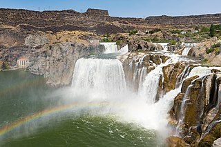
Shoshone Falls is a waterfall on the Snake River in southern Idaho, United States, approximately 3 miles (4.8 km) northeast of the city of Twin Falls. Sometimes called the "Niagara of the West," Shoshone Falls is 212 feet (65 m) high—45 feet (14 m) higher than Niagara Falls—and flows over a rim nearly 1,000 feet (300 m) wide.

The Payette River is an 82.7-mile-long (133.1 km) river in southwestern Idaho and is a major tributary of the Snake River.
Fort Boise is either of two different locations in the western United States, both in southwestern Idaho. The first was a Hudson's Bay Company (HBC) trading post near the Snake River on what is now the Oregon border, dating from the era when Idaho was included in the British fur company's Columbia District. After several rebuilds, the fort was ultimately abandoned in 1854, after it had become part of United States territory following settlement in 1846 of the northern boundary dispute.
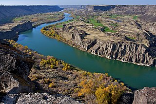
Snake River Canyon is a large canyon formed by the Snake River in the Magic Valley region of southern Idaho, forming part of the boundary between Twin Falls County to the south and Jerome County to the north.
Historic ferries in Oregon are water transport ferries that operated in Oregon Country, Oregon Territory, and the state of Oregon, United States. These ferries allowed people to cross bodies of water, mainly rivers such as the Willamette in the Willamette Valley, and the Columbia, in order to transport goods, move people, and further communications until permanent bridges were built to allow faster crossing of the water. The early ferries were used by wagons and pedestrians, while later ones transported trains and then automobiles. Oregon has a few automobile ferries still in operation.
The Lone Tree Ferry, later known as the Council Bluffs and Nebraska Ferry Company, was the crossing of the Missouri River at Council Bluffs, Iowa, and Omaha, Nebraska, US, that was established in 1850 by William D. Brown. Brown was the first pioneer to see the potential for a city on the site, and the landing became a popular gathering site for the first settlers of the Nebraska Territory. Named after a solitary tree on the Nebraska bank of the river, the Lone Tree Ferry became central to the founding and development of the City of Omaha.
Osgood is an unincorporated community near Idaho Falls in Bonneville County, Idaho, United States. It is part of the Idaho Falls, Idaho Metropolitan Statistical Area.

The path followed by the Oregon Trail, California Trail and Mormon Trail spans 400 miles (640 km) through the U.S. state of Wyoming. The trail entered from Nebraska on the eastern border of the state near the present day town of Torrington and exited on the western border near the towns of Cokeville and Afton. An estimated 350,000 to 400,000 settlers traveled on the trail through Wyoming between 1841 and 1868. All three trails follow the same path through most of the state. The Mormon Trail splits at Fort Bridger and enters Utah, while the Oregon and California Trails continue to Idaho.
The Shoshone was the first steamboat built on the Snake River, Idaho, above Hells Canyon and the first of only two steamboats to be brought down through Hells Canyon to the lower Snake River. This was considered one of the most astounding feats of steamboat navigation ever accomplished.

The Blackfoot Mountains, also called the Blackfoot Range, is a small range of mountains located east of Blackfoot, Idaho. Most of the area is private property, including the range's tallest mountain, Taylor Mountain. This mountain was named after Sam Taylor, an early settler and brother of Matt Taylor. The Blackfoot River carves through the region. Within this range is Wolverine Canyon, a public area that features sites for hiking, camping, kayaking, rock climbing and other recreational pursuits.

The Bonneville flood was a catastrophic flooding event in the last ice age, which involved massive amounts of water inundating parts of southern Idaho and eastern Washington along the course of the Snake River. Unlike the Missoula Floods, which also occurred during the same period in the Pacific Northwest, the Bonneville flood only happened once. The flood is believed to be the second largest in known geologic history.
The Oregon Trail is a historic 2,000-mile (3,264-km) trail used by American pioneers living in the Great Plains in the 19th century. The emigrants traveled by wagon in search of fertile land in Oregon's Willamette Valley.
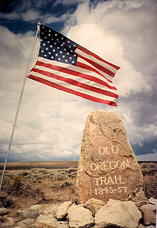
The historic 2,170-mile (3,490 km) Oregon Trail connected various towns along the Missouri River to Oregon's Willamette Valley. It was used during the 19th century by Great Plains pioneers who were seeking fertile land in the West and North.

Celebration Park is an archaeological park in the western United States, located in southwestern Idaho. It is the state's first archeological park and is adjacent to the Snake River near Melba and Walter's Ferry in Canyon County.
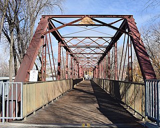
The Ninth Street Bridge in Boise, Idaho, also known as the Eighth Street Bridge, crosses the Boise River and is a 2-span, pin-connected Pratt through truss design constructed by the Missouri Valley Bridge & Iron Co. and completed in 1911. Each span is 160 ft (49 m) and includes six full panels and two end panels, supported by concrete piers at each end and midway in the river. Laced channel sections with cover plates form the upper chords, with eyebars on the lower chords. Eyebars with turnbuckles form the diagonals. The bridge was added to the National Register of Historic Places in 2001.


