Owyhee Mountains

Last updated
Owyhee Mountains
Owyhee Mountains.jpg
Owyhee Mountains and Noble Horse Barn viewed from the east
Highest point
PeakHayden Peak [1] ,Owyhee County, Idaho
Elevation 2,561 m (8,402 ft)
Dimensions
Length40 mi (64 km)NNW-SSE
Geography
USA Idaho relief location map.svg
Red triangle with thick white border.svg
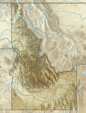
location of Owyhee Mountains in Idaho [2]
CountryUnited States
StateIdaho, and Oregon
District Owyhee County, Idaho and Malheur County, Oregon
Range coordinates 42°58′51″N116°39′31″W / 42.98083°N 116.65861°W / 42.98083; -116.65861
Parent range Owyhee Mountain Range
Topo map USGS  Cinnabar Mountain

The Owyhee Mountains are a mountain range in Owyhee County, Idaho and Malheur County, Oregon. [2]

Mahogany Mountain and the associated volcanic craters of the Lake Owyhee volcanic field are in the Owyhee Mountains of Oregon just east of the Owyhee Reservoir on the Owyhee River. [3]

The southeastern end of the range including the old mining area west of Silver City is referred to as the Silver City Range. [4] About 8.3 kilometres (5.2 mi) west of Silver City is the De Lamar ghost town in Jordan Creek below the mine workings on De Lamar Mountain to the south. [4] The area was active in the late 1880s. In the 1970s mining began again with the development of open pit silvergold mines on De Lamar Mountain. [5] [6]
Related Research Articles

<span class="mw-page-title-main">Owyhee County, Idaho</span> County in Idaho, United States

Owyhee County is a county in the southwestern corner of the U.S. state of Idaho. As of the 2020 census, the population was 11,913. The county seat is Murphy, and its largest city is Homedale. In area it is the second-largest county in Idaho, behind Idaho County.

<span class="mw-page-title-main">Jordan Valley, Oregon</span> City in Oregon, United States

Jordan Valley is a city in Malheur County, Oregon, United States. It is part of the Ontario, OR–ID Micropolitan Statistical Area. The city lies along Jordan Creek, a tributary of the Owyhee River; the creek is named for a 19th-century prospector, Michael M. Jordan. The population was 181 at the 2010 census.

<span class="mw-page-title-main">Owyhee River</span> River in Nevada, Idaho, and Oregon, United States

The Owyhee River is a tributary of the Snake River located in northern Nevada, southwestern Idaho and southeastern Oregon in the United States. It is 280 miles (450 km) long. The river's drainage basin is 11,049 square miles (28,620 km2) in area, one of the largest subbasins of the Columbia Basin. The mean annual discharge is 995 cubic feet per second (28.2 m3/s), with a maximum of 50,000 cu ft/s (1,400 m3/s) recorded in 1993 and a minimum of 42 cu ft/s (1.2 m3/s) in 1954.

<span class="mw-page-title-main">Yellowstone hotspot</span> Volcanic hotspot in the United States

The Yellowstone hotspot is a volcanic hotspot in the United States responsible for large scale volcanism in Idaho, Montana, Nevada, Oregon, and Wyoming, formed as the North American tectonic plate moved over it. It formed the eastern Snake River Plain through a succession of caldera-forming eruptions. The resulting calderas include the Island Park Caldera, Henry's Fork Caldera, and the Bruneau-Jarbidge caldera. The hotspot currently lies under the Yellowstone Caldera. The hotspot's most recent caldera-forming supereruption, known as the Lava Creek Eruption, took place 640,000 years ago and created the Lava Creek Tuff, and the most recent Yellowstone Caldera. The Yellowstone hotspot is one of a few volcanic hotspots underlying the North American tectonic plate; another example is the Anahim hotspot.

<span class="mw-page-title-main">Silver City, Idaho</span> Ghost town in Idaho, United States

Silver City is a ghost town in northwestern Owyhee County, Idaho, United States, that is listed on the National Register of Historic Places (NRHP). At its height in the 1880s, it was a gold and silver mining town with a population of around 2,500 and approximately 75 businesses.

The Clan Alpine Mountains are a mountain range located in west-central Nevada in the United States. The range lies in a southwest-northeasterly direction in Churchill County, and contains Mount Augusta, at 9,967 feet (3,038 m) above sea level. The mountains lie to the west of the Desatoya Mountains and southeast of the Stillwater Range. The Augusta Mountains lie to the northeast and the New Pass Range to the east. A large part of the range, 196,128 acres (793.70 km2), lies within the Clan Alpine Mountains Wilderness Study Area. The Clan Alpine Mountains lie to the north and northwest of Highway 50.

<span class="mw-page-title-main">Succor Creek</span> River in Oregon, United States

Succor Creek is a 69.4-mile-long (111.7 km) tributary of the Snake River in the U.S. states of Idaho and Oregon. The creek begins in the Owyhee Mountains in Owyhee County, Idaho. After flowing for about 23 miles (37 km) in Idaho, Succor Creek enters Malheur County, Oregon, where it flows for 39 miles (63 km) before re-entering Idaho for its final 5 miles (8.0 km). It joins the Snake near Homedale, about 413 river miles (665 km) from the larger river's confluence with the Columbia River.

<span class="mw-page-title-main">Bullfrog Hills</span> Mountain range in Nevada, United States

The Bullfrog Hills are a small mountain range of the Mojave Desert in southern Nye County, southwestern Nevada. Bullfrog Hills was so named from a fancied resemblance of its ore to the color of a bullfrog.

<span class="mw-page-title-main">Cuyamaca Mountains</span> Mountain range of the Peninsular Ranges System, in San Diego County, southern California

The Cuyamaca Mountains, locally the Cuyamacas, are a mountain range of the Peninsular Ranges System, in San Diego County, southern California. The mountain range runs roughly northwest to southeast. The Laguna Mountains are directly adjacent to the east, with Palomar Mountain and Hot Springs Mountain more distant to the north.

The Cerro Colorado Mountains are a low mountain range in southern Pima County, Arizona, USA. The highest point of the range is Colorado Peak. The range consists of a NNW–SSE trending ridge with several shorter ridges extending off the main ridge to the ENE. The higher portions of the range cover an area of about 21 km2 (8.1 sq mi), with dimensions of 6.8 km (4.2 mi) by 4.0 km (2.5 mi).

The South Pass greenstone belt is located within the Wyoming craton in the US. The region was the site of Wyoming's initial gold discovery in 1842.

<span class="mw-page-title-main">De Lamar, Idaho</span> United States historic place

De Lamar is a ghost town in Owyhee County, Idaho, United States. Its elevation is 5,463 ft (1,665 m), and it is approximately 6 mi (9.7 km) west of Silver City. The community lies within an area governed by the Bureau of Land Management.

<span class="mw-page-title-main">Black Hills (Yavapai County)</span> Landform in Yavapai County, Arizona

The Black Hills of Yavapai County are a large mountain range of central Arizona in southeast Yavapai County. It is bordered by the Verde Valley to the east. The northwest section of the range is bisected from the southeast section by Interstate 17, which is the main route connecting Phoenix to Sedona, Oak Creek Canyon, and Flagstaff. This bisection point is the approximate center of the mostly northwest by southeast trending range. The northwest section contains a steep escarpment on the northeast with the Verde Valley, the escarpment being the location of the fault-block that created the historic mining district at Jerome. The United Verde Mine was one of the largest copper mines in the United States, producing large quantities of copper, gold, silver and zinc.

The West Silver Bell Mountains are a small 10 mile (16 km) long mountain range of south-central Arizona, United States. The range lies in the north-central arid Sonoran Desert; the Madrean Sky Islands region of southeast Arizona, around Tucson is adjacent to the southeast.

<span class="mw-page-title-main">Sierra Madre Range (Wyoming)</span>

The Sierra Madre Range is a mountain range in the western United States, located in south-central Wyoming and north-central Colorado. Geologically, it may be considered an extension of the Park Range of Colorado. South of the Great Divide Basin, the US Continental Divide runs along the Sierre Madre high points. Its western basins drain into the Colorado River and its eastern into the North Platte River. Buck Mountain is the highest peak in the range and lies within Colorado. Bridger Peak is its highest elevation on the Wyoming side of the range.

The Las Guijas Mountains are a small northwest–southeast trending mountain range in southern Pima County, Arizona. The range is approximately 12 kilometres (7.5 mi) long by 4 km (2.5 mi). Surrounding ranges includes the Cerro Colorado Mountains to the northeast, the Tumacacori Mountains of Santa Cruz County to the east, the San Luis Mountains to the south and the Baboquivari Mountains across the Altar Valley to the west. Arivaca is immediately to the southeast and the old mining townsite of Las Guijas is in the wash just north of the range.

Amethyst Mountain, el. 9,609 feet (2,929 m) is the highest peak and central part of a northwest – southeast trending ridge that lies between the Lamar River to the northeast and Deep Creek to the southwest within Park County, Wyoming. From northwest to southeast, this ridge consists of Specimen Ridge, Amethyst Mountain, and the Mirror Plateau in Yellowstone National Park. The nearest town is Silver Gate, Montana, which is 19.2 miles away.

The Battle Mountains or Battle Mountain Range is a mountain range in western Lander and southeastern Humboldt counties of Nevada. The communities of Battle Mountain and Valmy lie just to the east and north respectively along Interstate 80 in the Humboldt River valley. Nevada State Route 305 runs along the southeast side of the range from Battle Mountain toward Austin to the south.

The DeLamar Mine was an open-pit silver and gold mine in Owyhee County in southwest Idaho, which operated from 1977 to 1998. John Guilbert and Charles Park, Jr. have described the DeLamar mine as "the first modern open-pit silver mine." It is located about one mile from the ghost town of De Lamar, Idaho, which had been a mining center in the late 19th and early 20th century. The mine was under construction from 1975 to 1977 and began operations in 1977; the first extracted silver was poured in April 1977. The mine employed 125 workers when it opened, with the bulk of its workforce living in Jordan Valley, Oregon, around 18 miles away. At the time of its closure in 1998, the mine had five major pits and was owned by Kinross Gold Corporation.

Roderick R. Asher (1931-1997) was an American geologist and mining engineer, best known for his field work in Mexico, Alaska, and the Great Basin region of the United States as well as his published works.

References

  1. Cinnabar Mountain, Idaho, 7.5 Minute Topographic Quadrangle, USGS, 1990
  2. 1 2 "Owyhee Mountains". Geographic Names Information System . United States Geological Survey, United States Department of the Interior.
  3. Cummings, Michael L., et al., Stratigraphic and structural evolution of the middle Miocene synvolcanic Oregon-Idaho graben, Geological Society of America Bulletin, 2000; v. 112, no. 5; pp. 668-682
  4. 1 2 Murphy, Idaho, 30x60 Minute Topographic Quadrangle, USGS, 1986
  5. Bonnichsen, Bill; Epithermal Gold and Silver Deposits Silver City–De Lamar District, Idaho, University of Idaho, Idaho Geological Survey, Technical Report 83-4, 1983 PDF
  6. De Lamar, Idaho, 7.5 Minute Topographic Quadrangle, USGS, 1990

Further reading