
The named mountain ranges of Utah.
The named mountain ranges of Utah.
The listing, with county designations.
|

Sanpete County is a county in the U.S. state of Utah. As of the 2020 United States Census, the population was 28,437. Its county seat is Manti, and its largest city is Ephraim. The county was created in 1850.
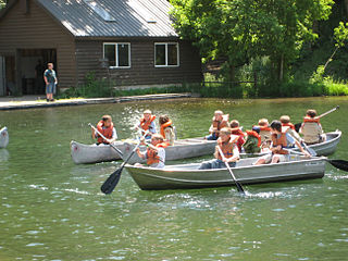
Scouting in Utah has a long history, from the 1910s to the present day, serving thousands of youth in programs that suit the environment in which they live.

The Sevier River is a 400-mile (640 km)-long river in the Great Basin of southwestern Utah in the United States. Originating west of Bryce Canyon National Park, the river flows north through a chain of high farming valleys and steep canyons along the west side of the Sevier Plateau before turning southwest and terminating in the endorheic basin of Sevier Lake in the Sevier Desert. It is used extensively for irrigation along its course, with the consequence that Sevier Lake is usually dry.

Fishlake National Forest is a U.S. National Forest located in south central Utah. The namesake for the forest is Fish Lake, the largest freshwater mountain lake in the state.

Uinta National Forest is a national forest located in north central Utah, US. It was originally part of the Uinta Forest Reserve, created by President Grover Cleveland on 2 February 1897. The name is derived from the Ute word Yoov-we-teuh which means pine forest. Because of changes to the boundaries over the years, the Uinta Mountains are now located in the Wasatch-Cache National Forest. In August 2007 it was announced that the Uinta National Forest would merge with the Wasatch–Cache National Forest based in Salt Lake City, Utah, 50 miles (80 km) north of Provo, Utah.

Wasatch–Cache National Forest is a United States National Forest located primarily in northern Utah (81.23%), with smaller parts extending into southeastern Idaho (16.42%) and southwestern Wyoming (2.35%). The name is derived from the Ute word Wasatch for a low place in high mountains, and the French word Cache meaning to hide. The term cache originally referred to fur trappers, the first Europeans to visit the land. The Wasatch–Cache National Forest boundaries include 1,607,177 acres (6,504.01 km2) of land.

Wasatch National Forest was established as the Wasatch Forest Reserve by the U.S. Forest Service in Utah on August 16, 1906 with 86,440 acres (349.8 km2) to the east of Salt Lake City and Provo. It became a National Forest on March 4, 1907. On July 1, 1908 Grantsville National Forest and Salt Lake National Forest were added. In 1973 Wasatch was combined administratively with Cache National Forest, creating Wasatch-Cache National Forest. In descending order of acreage, the Wasatch National Forest portion is located in Summit, Tooele, Salt Lake, Davis, Uinta (Wyoming), Duchesne, Wasatch, Morgan, Utah, Weber, and Juab counties in Utah except Uinta, which is in southwestern Wyoming. Its total area was 908,731 acres (3,677.50 km2), comprising 56.44% of the combined Wasatch-Cache's 1,610,184 acres (6,516.18 km2) as of 2008. There are local ranger district offices in Kamas and Salt Lake City in Utah, and in Evanston and Mountain View in Wyoming. Administrative headquarters reside with the combined Uinta-Wasatch-Cache National Forest in South Jordan, Utah.

The Tushar Mountains are the third-highest mountain range in Utah after the Uinta Mountains and the La Sal Range. Located in the Fishlake National Forest, Delano Peak, 12,174 ft NAVD 88, is the highest point in both Beaver and Piute counties and has a prominence of 4,689 ft. Delano Peak is named for Columbus Delano (1809–1896), Secretary of the Interior, during the Grant administration. The Tushars receive an ample amount of snow annually even though they are situated within the rainshadow of the Sierra Nevada range in California and the Snake Range located in Nevada.

The Utah Children's Justice Center (CJC) is a program of the Utah Attorney General's Office to coordinate investigation and prosecution of child abuse, especially child sexual abuse. There are 22 CJC's in the state of Utah. They were created to provide a child friendly environment for interviews and exams of child victims as well as to provide support and centralized resource referrals to victim's families. In 2021, Joy D. Jones presented a $300,000 gift from the Church of Jesus Christ of Latter-day Saints to assist their 26 centers throughout the state.

Adult Probation and Parole (AP&P) is a division of the Utah Department of Corrections (UDC) which is a government agency dedicated to the management and supervision of convicted probationers and parolees in the State of Utah. It is currently led by the Division Director Dan Blanchard and is headquartered in the Utah Department of Corrections Administration Building in Draper.
The Crossroads of the West Council is a local council of the Boy Scouts of America that serves the Scouts in all of Utah, Bear Lake and Franklin counties in southeastern Idaho, and Uinta, Sweetwater, Sublette, and a portion of Lincoln counties in southwestern Wyoming.
The Utah Constitutional Convention was held from March 4, 1895 to May 8, 1895. The 1895 convention was the Utah Territory's seventh and final attempt to be admitted to the United States as a state. The Constitution of Utah was accepted by Congress and President Grover Cleveland, leading to Utah's admittance into the union as the 45th state on January 4, 1896.
![]() Media related to Mountain ranges of Utah at Wikimedia Commons
Media related to Mountain ranges of Utah at Wikimedia Commons