The Star Range is an 8-mile (12 km) long, small mountain range located in central Beaver County, Utah. The range is "star"-shaped as small ridges end at peaks, like fingers of a hand. Another adjacent range sequence southwest, the Shauntie Hills has other fingers of the star-shape.

The Sugarland Mountain Trail is an American hiking trail, in the Great Smoky Mountains National Park of Sevier County, Tennessee. The trail traverses Sugarland Mountain, a massive ridge running perpendicular to the main crest of the Smokies and effectively dividing the park's north-central section from its northwestern section. Sugarland Mountain is flanked by the deep upper valleys of two of the park's major watersheds— the West Fork of the Little Pigeon River and Little River. The trail passes through several forest types, including deciduous forest at lower elevations, heaths ("hells") along the mountain's backbone formations, and a stand of Southern Appalachian spruce-fir forest in the upper elevations. Occasional breaks in the foliage allow for views of Mount Le Conte and Sevier County to the east and Blanket Mountain and the ridges above Elkmont to the west.

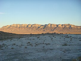
The House Range is a north-south trending mountain range in Millard County, of west-central Utah. The House Range was named in 1859 by James H. Simpson. It was named by Simpson because "...of its well-defined stratification and the resemblance of portions of its outline to domes, minarets, houses, and other structures."

The Sevier Desert is a large arid section of central-west Utah, United States, and is located in the southeast of the Great Basin. It is bordered by deserts north, west, and south; its east border is along the mountain range and valley sequences at the perimeter of the Great Basin, with the large north–south Wasatch Range and its associated mountainous landforms. Its eastern border is specifically, the East Tintic, Gilson, and Canyon Mountains; also the massive Pahvant Range.
The Santa Maria Mountains are a 16-mi (26 km) long mountain range in central-northwest Arizona, and in northwest Yavapai County. The range lies in a region of mesas and mountain ranges in the northwest of Arizona's transition zone. The Santa Maria Mountains lie east of the transition zone's northwest perimeter, the parallel Aquarius and Mohon Mountains.

The Canyon Mountains are a 25-mile (40 km) long mountain range located in the northeast corner of Millard County, Utah; the range is bisected north-south with a southeast border section of Juab County.
The Beaver Dam Mountains are a 23 miles (37 km) long mountain range located mostly in extreme southwest Washington County, Utah, west of St. George, with the south of the range extending into the Arizona Strip.
The Fish Springs Range is a 16-mile (26 km) long narrow, and north-trending mountain range located in center-west Juab County, Utah. The northeast of the range borders the Fish Springs National Wildlife Refuge; the entire east of the range borders the Fish Springs Flat, where the east region of the flat borders the Thomas Range.

The San Pitch Mountains are a 40-mile (64 km) long mountain range located in Juab and Sanpete counties in central Utah, United States.

The Cedar Mountains of Tooele County, Utah, USA, are a 45-mile (72 km) long mountain range located in the county's east, bordering east sections of the Great Salt Lake Desert on the range's west and southwest flanks.

The Lakeside Mountains are about a 34 miles (55 km) long mountain range located on the southwest perimeter of the Great Salt Lake; the range is located in northeast Tooele County and south Box Elder County in Utah, United States.
The Gilson Mountains are an 11-mile (18 km) long almost circular, small mountain range adjacent the north terminus of the Canyon Mountains,, located in far eastern Juab County, Utah, United States.
The Black Mountains is a 30-mile (48 km) long mountain range in northeastern Iron County and southeastern Beaver County in southwestern Utah, United States.
The Sheeprock Mountains are a 24-mile (39 km) long mountain range located in extreme southeast Tooele County, Utah, and part of northeast Juab County. The range trends southeasterly and forms a section of the northeast perimeter of the large Sevier Desert, which lies southwest of the Sheeprock Mountains.

The Mineral Mountains are a 28 miles (45 km) long mountain range located in eastern Beaver and southeastern Millard counties in southwestern Utah. The Escalante Desert is to its southwest, the Black Rock Desert volcanic field and the Sevier Desert are to the north and northwest. The Pavant Range and Tushar Mountains lie to the east.
The Dugway Range is a 13-mile (21 km) long mountain range located in central-south Tooele County, Utah, on the Juab County north border.
The Moccasin Mountains is an 11-mile-long (18 km) mountain range located at the Arizona–Utah border in Mohave County, Arizona, and a small north section in Kane County, Utah.
Buckskin Mountain is a 16-mile (26 km) mountain ridge that spans from Coconino County, Arizona to Kane County, Utah in the United States, that is divided almost equally between the two counties.

The Valley Mountains are a 28-mile-long (45 km) mountain range located on the southwest border of Sanpete County, Utah, United States, with the northeast border of Millard County. The north of the range is in Juab County; the south in Sevier County.
The Peacock Mountains are a small, 26 mi (42 km) long mountain range in northwest Arizona, US. The range is a narrow sub-range, and an extension north, at the northeast of the Hualapai Mountains massif, which lies to the southwest. The range is defined by the Hualapai Valley to the northwest, and north and south-flowing washes on its east border, associated with faults and cliffs; the Cottonwood Cliffs are due east, and are connected to the Aquarius Cliffs southward at the west perimeter of the Aquarius Mountains; the cliffs are a result of the Aquarius Fault, which is an extension southward from the Grand Wash Cliffs and Grand Wash Fault which crosses the Colorado River at Lake Mead, and the west perimeter of the Grand Canyon/Colorado Plateau.