Sevier Desert

Last updated
Sevier Desert
Sevier River Leamington Utah.jpg
Gilson Mountains, Sevier River entering the east Sevier Desert at Leamington
USA Utah location map.svg
Red pog.svg
Sevier Desert
Length105 mi (169 km)
Width60 mi (97 km)
Geography
Country United States
State Utah
Counties Juab and Millard
Borders on Ferguson Desert-W
Great Salt Lake Desert-NW & NNW
Gilson & Canyon Mountains, and
Pavant Range-E
Escalante Desert-SW
Coordinates 39°25′00″N112°40′03″W / 39.41661°N 112.66745°W / 39.41661; -112.66745 Coordinates: 39°25′00″N112°40′03″W / 39.41661°N 112.66745°W / 39.41661; -112.66745
River Sevier River
Lake Sevier Lake

The Sevier Desert is a large arid section of central-west Utah, United States, and is located in the southeast of the Great Basin. It is bordered by deserts north, west, and south; its east border is along the mountain range and valley sequences at the perimeter of the Great Basin, with the large north–south Wasatch Range and its associated mountainous landforms. Its eastern border is specifically, the East Tintic, Gilson, and Canyon Mountains; also the massive Pahvant Range.

Contents

The Sevier Desert contains the course of the Sevier River in a circuitous manner. It flows to Sevier Lake in the extreme southwest Sevier Desert. The Sevier River enters the east desert flowing west, immediately turning southwest, then west, to enter the north of Sevier Lake, which is mostly south-southwest trending.

The southeast section of the desert contains the Black Rock Desert volcanic field, with the notable Pahvant Butte, a formation from the time of Lake Bonneville. The volcanic field region is west of an agricultural four-city region from McCornick to Fillmore. [1]

The Little Sahara Recreation Area is located in the northeast of the desert.

Description

USA Utah location map.svg
Red pog.svg
Red pog.svg
Red pog.svg
Red pog.svg
Red pog.svg
Red pog.svg
Red pog.svg
Red pog.svg
Red pog.svg
Red pog.svg
Red pog.svg
Red pog.svg
Red pog.svg
Red pog.svg
Red pog.svg
Red pog.svg
Selected perimeter sites, (city-or-landform locations)


The desert is about 105-mi (169 km) long north–south, and about 60-mi (97 km) wide. [2] The desert covers a large section of the central-north Sevier River drainage (11,574 sq mi (29,980 km2)), and much of the east half of Millard County (6,828 sq mi (17,680 km2)). The Sevier Desert is named for the river, which is derived from "Río Severo" (wild river), a local name given by early Spanish explorers. [3]

In the north and northwest, the desert is composed of small mountain ranges, a few valleys, flatlands, and borders the south-southeast of the Great Salt Lake Desert. The Dugway Range and Dugway Valley on the Great Salt Lake Desert's perimeter, borders the Thomas Range, southeast. The Thomas Range and Drum Mountains lie due west of the Little Sahara Recreation Site. A large dissected flatland lies between drained southwesterly by Cherry Creek Wash. The region contains intermittent reservoirs, Hogback, Crater Bench, and Desert Mountain Reservoir. Also various springs, or wells. It is also the site of Fumarole Butte, 5,278 feet (1,609 m), about 10 miles (16 km) east [4] of the Drum Mountains.

Geographical layout

The west perimeter of the Sevier Desert has mostly a north–south border because of the House Range. The south desert perimeter is mostly east–west because the mountains on the south separate the Sevier from the Escalante Desert, an approximate triangle-shaped desert enclosed amongst mountain ranges, and the Escalante and Cedar Valleys. The east of the Sevier Desert contains the communities lying at the foothills of the mountain ranges. The Black Rock Desert volcanic field is located west of the cities. Pavant Valley lies at the west of the Pahvant Range, and west of the Canyon Mountains lies the Oak Creek Sinks adjacent east of the Sevier River, and west of Oak City.

The northeast perimeter of the desert lies at the southwest foothills of the East Tintic Mountains, noted for its mining. Tintic Valley, a small valley between the West Tintic Mountains feeds southwesterly into the Sevier Desert. Adjacent west of the West Tintics, lie two additional bordering mountain ranges, the southwest flank of the Sheeprock Mountains and the small, circular Simpson Mountains west.

In the west and southwest, west of the House Range, is the Ferguson Desert; the Confusion Range and Tule Valley lie between the House Range and the Ferguson Desert.

List of cities and landforms

The following is a list of communities or landforms associated with the north, south, east and west desert perimeters (approximate to mountain foothills, valleys, etc.).

Route access

Interstate 15 transits the southeast perimeter of the desert along mountain foothills. Utah State Route 257 transits north, then northeast through the center-east desert, from Black Rock, Utah to Oasis. U.S. 6 continues northeast from Oasis to Jericho and McIntyre, at the northeast perimeter of the desert. U.S. 6 is also the access route to the Little Sahara Recreation Area in the northeast.

Related Research Articles

Rush Valley

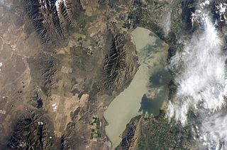
Rush Valley is a 30-mile (48 km) long north-trending valley in the southeast of Tooele County, Utah. It lies adjacent and attached at the south of Tooele Valley; the separation point is the lowpoint of the valley at Rush Lake, and lies at the southeast of the small mountain massif causing the separation, South Mountain at 6,541 feet (1,994 m). The region of Rush Lake is a marsh region, fed by various streams from the mountain regions east and west.

Star Range

The Star Range is an 8-mile (12 km) long, small mountain range located in central Beaver County, Utah. The range is "star" shaped as small ridges end at peaks, like fingers of a hand. Another adjacent range sequence southwest, the Shauntie Hills has other fingers of the star-shape.

Canyon Mountains

The Canyon Mountains are a 25-mile (40 km) long mountain range located in the northeast corner of Millard County, Utah; the range is bisected north-south with a southeast border section of Juab County.

San Francisco Mountains (Utah) American mountain range

The San Francisco Mountains are a 20-mile-long (32 km) mountain range located in north‑central Beaver County, Utah, United States that extend into central-south Millard County.

Fish Springs Range

The Fish Springs Range is a 16-mile (26 km) long narrow, and north-trending mountain range located in center-west Juab County, Utah. The northeast of the range borders the Fish Springs National Wildlife Refuge; the entire east of the range borders the Fish Springs Flat, where the east region of the flat borders the Thomas Range.

Goshen Valley

The Goshen Valley is a 17-mile-long (27 km) valley located in southern Utah County, Utah, and the valley forms part of its southeast border with the Wasatch Front, and parts of the Wasatch Range. The valley is an extension southwesterly of the Utah Valley.

Stansbury Mountains Mountain range in Tooele County, Utah, United States

The Stansbury Mountains are a 28-mile (45 km) long mountain range located in eastern Tooele County, Utah. It is named for U.S. Army Major Howard Stansbury, a topographical engineer, who led an expedition that surveyed the region.

Skull Valley (Utah) Valley in northwestern Utah, United States

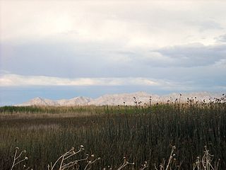
Skull Valley is a 40-mile (64 km) long valley located in east Tooele County, Utah, United States at the southwest of the Great Salt Lake. The valley trends north–south, but turns slightly northeast to meet Stansbury Bay,.

Cedar Mountains (Tooele County, Utah)

The Cedar Mountains of Tooele County, Utah, USA, are a 45-mile (72 km) long mountain range located in the county's east, bordering east sections of the Great Salt Lake Desert on the range's west and southwest flanks.

Lakeside Mountains

The Lakeside Mountains are about a 34 miles (55 km) long mountain range located on the southwest perimeter of the Great Salt Lake; the range is located in northeast Tooele County and south Box Elder County in Utah, United States.

Gilson Mountains

The Gilson Mountains are an 11-mile (18 km) long almost circular, small mountain range adjacent the north terminus of the Canyon Mountains,, located in far eastern Juab County, Utah, United States.

Cedar Valley (Iron County, Utah)

The Cedar Valley of Iron County, Utah, United States is a 25-mile (40 km) long valley located in the southeast of the county, against the Hurricane Cliffs which border the Cedar Mountains and the Markagunt Plateau.

Black Mountains (Utah)

The Black Mountains is a 30-mile (48 km) long mountain range in northeaster Iron County and southeastern Beaver County in southwestern Utah, United States.

Sheeprock Mountains

The Sheeprock Mountains are a 24-mile (39 km) long mountain range located in extreme southeast Tooele County, Utah, and part of northeast Juab County. The range trends southeasterly and forms a section of the northeast perimeter of the large Sevier Desert, which lies southwest of the Sheeprock Mountains.

Mineral Mountains (Utah)

The Mineral Mountains are a 28 miles (45 km) long mountain range located in eastern Beaver and southeastern Millard counties in southwestern Utah. The Escalante Desert is to its southwest, the Black Rock Desert volcanic field and the Sevier Desert are to the north and northwest. The Pavant Range and Tushar Mountains lie to the east.

Dugway Range

The Dugway Range is a 13-mile (21 km) long mountain range located in central-south Tooele County, Utah, on the Juab County north border.

Valley Mountains

The Valley Mountains are a 28-mile (45 km) long mountain range located on the southwest border of Sanpete County, Utah, with the northeast border of Millard County. The north of the range is in Juab County; the south in Sevier County.

Beaver Lake Mountains

Beaver Lake Mountains is an 8-mile (13 km) long mountain in central and north Beaver County, Utah, United States adjacent the south border of Millard County.

Defiance Plateau Region in the United States

The Defiance Plateau, part of the geologic Defiance Uplift, is an approximately 75-mile (121 km) long, mostly north-trending plateau of Apache County, Arizona, with its east and southeast perimeter, as parts of San Juan and McKinley Counties, New Mexico.

Peacock Mountains

The Peacock Mountains are a small, 26-mi (42 km) long mountain range in northwest Arizona, USA. The range is a narrow sub-range, and an extension north, at the northeast of the Hualapai Mountains massif, which lies to the southwest. The range is defined by the Hualapai Valley to the northwest, and north and south-flowing washes on its east border, associated with faults and cliffs; the Cottonwood Cliffs are due east, and are connected to the Aquarius Cliffs southward at the west perimeter of the Aquarius Mountains; the cliffs are a result of the Aquarius Fault, which is an extension southward from the Grand Wash Cliffs and Grand Wash Fault which crosses the Colorado River at Lake Mead, and the west perimeter of the Grand Canyon/Colorado Plateau.

References

  1. Utah DeLorme Atlas, pp. 34, 42.
  2. Utah DeLorme Atlas & Gazetteer, pp. 23, 31, 34, 41, 42.
  3. Van Cott, J. W., 1990, Utah Place Names, ISBN   0-87480-345-4
  4. Utah DeLorme Atlas, pp. 31 & 34.