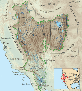
The Great Basin is the largest area of contiguous endorheic watersheds, those with no outlets to the ocean, in North America. It spans nearly all of Nevada, much of Utah, and portions of California, Idaho, Oregon, Wyoming, and Baja California. It is noted for both its arid climate and the basin and range topography that varies from the North American low point at Badwater Basin in Death Valley to the highest point of the contiguous United States, less than 100 miles (160 km) away at the summit of Mount Whitney. The region spans several physiographic divisions, biomes, ecoregions, and deserts.

The Black Rock Desert is a semi-arid region of lava beds and playa, or alkali flats, situated in the Black Rock Desert–High Rock Canyon Emigrant Trails National Conservation Area, a silt playa 100 miles (160 km) north of Reno, Nevada that encompasses more than 300,000 acres (120,000 ha) of land and contains more than 120 miles (200 km) of historic trails. It is in the northern Nevada section of the Great Basin with a lakebed that is a dry remnant of Pleistocene Lake Lahontan.

The Great Basin Desert is part of the Great Basin between the Sierra Nevada and the Wasatch Range. The desert is a geographical region that largely overlaps the Great Basin shrub steppe defined by the World Wildlife Fund, and the Central Basin and Range ecoregion defined by the U.S. Environmental Protection Agency and United States Geological Survey. It is a temperate desert with hot, dry summers and snowy winters. The desert spans large portions of Nevada and Utah, and extends into eastern California. The desert is one of the four biologically defined deserts in North America, in addition to the Mojave, Sonoran, and Chihuahuan Deserts.

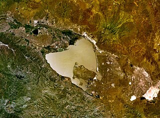
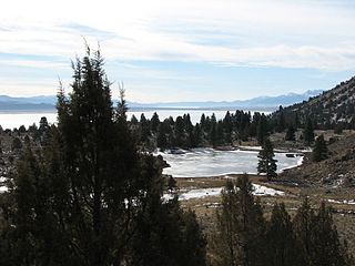
Pyramid Lake is the geographic sink of the basin of the Truckee River, 40 mi (64 km) northeast of Reno, Nevada, United States.

Lake Lahontan was a large endorheic Pleistocene lake of modern northwestern Nevada that extended into northeastern California and southern Oregon. The area of the former lake is a large portion of the Great Basin that borders the Sacramento River watershed to the west.
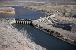
Derby Dam is a diversion dam built from 1903 to 1905 on the Truckee River, located about 20 miles (32 km) east of Reno in Storey and Washoe counties in Nevada, United States. It diverts water into the Truckee Canal that would otherwise enter Pyramid Lake. The canal feeds Lake Lahontan reservoir in the Carson River watershed, where it is used for irrigation.

The Truckee River is a river in the U.S. states of California and Nevada. The river flows northeasterly and is 121 miles (195 km) long. The Truckee is the sole outlet of Lake Tahoe and drains part of the high Sierra Nevada, emptying into Pyramid Lake in the Great Basin. Its waters are an important source of irrigation along its valley and adjacent valleys.

The Humboldt Sink is an intermittent dry lake bed, approximately 11 mi (18 km) long, and 4 mi (6 km) across, in northwestern Nevada in the United States. The body of water in the sink is known as Humboldt Lake. The sink and its surrounding area was a notorious and dreaded portion of overland travel to California during the westward migrations of the mid-1800s, which were largely undertaken along the California Trail.

Carson Sink is a playa in the northeastern portion of the Carson Desert in present-day Nevada, United States of America, that was formerly the terminus of the Carson River. Today the sink is fed by drainage canals of the Truckee-Carson Irrigation District. The southeastern fringe of the sink, where the canals enter, is a wetland of the Central Basin and Range ecoregion.

The Carson River is a northwestern Nevada river that empties into the Carson Sink, an endorheic basin. The main stem of the river is 131 miles (211 km) long although the addition of the East Fork makes the total length 205 miles (330 km), traversing five counties: Alpine County in California and Douglas, Storey, Lyon, and Churchill Counties in Nevada, as well as the Consolidated Municipality of Carson City, Nevada. The river is named for Kit Carson, who guided John C. Frémont's expedition westward up the Carson Valley and across Carson Pass in winter, 1844. The river made the National Priorities List (NPL) on October 30, 1990 as the Carson River Mercury Superfund site (CRMS) due to investigations that showed trace amounts of mercury in the wildlife and watershed sediments.
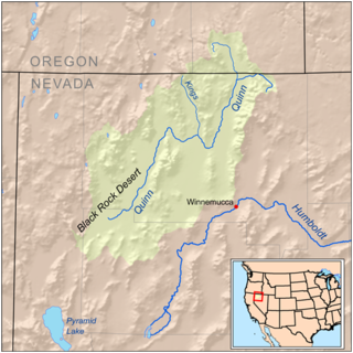
The Quinn River, once known as the Queen River, is an intermittent river, approximately 110 miles (180 km) long, in the desert of northwestern Nevada in the United States. It drains an enclosed basin inside the larger Great Basin.

The Walker River is a river in west-central Nevada in the United States, approximately 62 miles (100 km) long. Fed principally by snowmelt from the Sierra Nevada of California, it drains an arid portion of the Great Basin southeast of Reno and flows into the endorheic basin of Walker Lake. The river is an important source of water for irrigation in its course through Nevada; water diversions have reduced its flow such that the level of Walker Lake has fallen 160 feet (49 m) between 1882 and 2010. The river was named for explorer Joseph Reddeford Walker, a mountain man and experienced scout who is known for establishing a segment of the California Trail.

Lahontan State Recreation Area is a public recreation area surrounding Lake Lahontan, a 17-mile-long (27 km) impoundment of the Carson River, located approximately 18 miles (29 km) west of Fallon, Nevada. The reservoir features 69 miles (111 km) of shoreline and 11,200 acres (4,500 ha) of water when full. Much of the park lies below 4,000 feet (1,200 m) in elevation and is dominated by high desert sagebrush. Wooded areas of native cottonwoods and willow trees can be found along the shore of the lake. Primary access points to the park are along U.S. Route 50 near the Lahontan Dam and off U.S. Route 95 in the town of Silver Springs. A corridor known as Carson River Ranches connects Lahontan with Fort Churchill State Historic Park.
Honey Lake is an endorheic sink in the Honey Lake Valley in northeastern California, near the Nevada border. Summer evaporation reduces the lake to a lower level of 12 square kilometers and creates an alkali flat. Honey Lake dries almost completely in most years.

The Soda Lakes are two lakes located northwest of Fallon, Nevada. They occupy two basaltic maar volcano craters which may have erupted in the last 1500 years. The larger lake, called Soda Lake or Big Soda Lake, is somewhat elongated, stretching 2 kilometers (1.2 mi) in length. The smaller one, Little Soda Lake, is 200 meters (660 ft) across. Considered to be a single volcano, the combined craters are young enough that future activity can't be ruled out. A geothermal power plant is located on the northeast flank of the volcano.
The Lahontan Valley is a basin in Churchill County, Nevada, United States. The valley is a landform of the central portion of the prehistoric Lake Lahontan's lakebed of 20,000-9,000 years ago. The valley and the adjacent Carson Sink represent a small portion of the lake bed. Humboldt Lake is to the valley's northeast. Pyramid Lake is west. Walker Lake is to the south. The valley is part of the larger Great Basin Desert, however during the California Gold Rush the valley was often called the Forty Mile Desert.

The landlocked U.S. state of Nevada has a varied geography and is almost entirely within the Basin and Range Province and is broken up by many north–south mountain ranges. Most of these ranges have endorheic valleys between them.
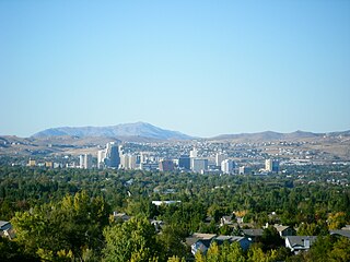
Western Nevada (WNV) is a region and the northwestern portion of the U.S. state of Nevada that includes Reno, Carson City, Carson Valley and Virginia City. Lyon County and Churchill County are sometimes also referred to as part of Western Nevada.
The Alkali Lakes are a series of three large playas located in the Surprise Valley of northeastern California, United States. From north to south they are known as Upper, Middle and Lower Alkali Lake. Upper Alkali Lake is often known simply as Upper Lake, and Lower Alkali Lake as Lower Lake. Although mostly located in Modoc County, California, the eastern edges of Middle and Lower Lakes touch Washoe County, Nevada. The Warner Mountains are located to the west of the three lakes. The lake beds are typically flooded with shallow water in the winter but dry up during most summers.
