Carson Sink | |
---|---|
![]() View southeast across the Carson Sink from Topog Peak in the West Humboldt Range | |
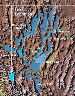
![]() The Carson Sink and the Lahontan Valley form the central portion of the lake bed of the prehistoric Lake Lahontan. | |
Coordinates: 39°52′40″N118°20′50″W / 39.87778°N 118.34722°W | |
Location | Lahontan Basin, Nevada |
Area | |
• Total | 300 sq mi (780 km2) |
Carson Sink is a playa in the northeastern portion of the Carson Desert in present-day Nevada, United States of America, that was formerly the terminus of the Carson River. Today the sink is fed by drainage canals of the Truckee-Carson Irrigation District. The southeastern fringe of the sink, where the canals enter, is a wetland of the Central Basin and Range ecoregion. [1]
This is mostly included within the Fallon National Wildlife Refuge and the Stillwater Wildlife Management Area. This area serves as an important stopover for migrating waterfowl. The Sehoo Formation is south of the Carson Sink. [2]
The Carson Sink and Lone Rock working areas are the northwest portion of both the Carson Sink and the US Naval Fallon Range Training Complex. [3] The Lone Rock working area includes the Bravo-20 range, which has numerous targets for combat aircraft training. [3]
Lone Rock is in the middle of a Bravo-20 live bombing area. [3] It is a solitary pinnacle of rock through the playa and it is held sacred by the Northern Paiute. [4]
The Carson Sink was a deep portion of the Pleistocene water body Lake Lahontan, [5] the lakebed of which is now the Lahontan Basin.
The Carson Trail, used during the California Gold Rush across the Lahontan Basin, included a section through the Forty Mile Desert to the first drinkable water on the Carson River. [6] The Carson Sink station of the Pony Express was built in March 1860. [7]
In June 1952 two U.S. Air Force colonels flew a B-25 bomber from Hamilton Field near San Francisco to Colorado Springs, Colorado. While passing over Carson Sink, the two reportedly saw three unknown aircraft fly within 800 yards of their aircraft before speeding out of sight seconds later. Upon landing, the two colonels reported the incident to the Air Defence Command headquarters, who informed them that there were no military or civilian aircraft in the area at the time. The incident was never resolved and is known today as the Carson Sink UFO incident. [8]
In 1984, the natural dike between the Carson Sink and the Humboldt Sink was breached by the Nevada Department of Transportation to prevent Interstate 80 and the town of Lovelock from flooding due to unusually heavy snowfall in the preceding three years. The sinks remained connected by water for three years, until 1987.
The Great Basin is the largest area of contiguous endorheic watersheds, those with no outlets to the ocean, in North America. It spans nearly all of Nevada, much of Utah, and portions of California, Idaho, Oregon, Wyoming, and Baja California. It is noted for both its arid climate and the basin and range topography that varies from the North American low point at Badwater Basin in Death Valley to the highest point of the contiguous United States, less than 100 miles (160 km) away at the summit of Mount Whitney. The region spans several physiographic divisions, biomes, ecoregions, and deserts.
The Black Rock Desert is a semi-arid region of lava beds and playa, or alkali flats, situated in the Black Rock Desert–High Rock Canyon Emigrant Trails National Conservation Area, a silt playa 100 miles (160 km) north of Reno, Nevada, that encompasses more than 300,000 acres (120,000 ha) of land and contains more than 120 miles (200 km) of historic trails. It is in the northern Nevada section of the Great Basin with a lakebed that is a dry remnant of Pleistocene Lake Lahontan.
Owens Valley is an arid valley of the Owens River in eastern California in the United States. It is located to the east of the Sierra Nevada, west of the White Mountains and Inyo Mountains, and is split between the Great Basin Desert and the Mojave Desert. The mountain peaks on the West side reach above 14,000 feet (4,300 m) in elevation, while the floor of the Owens Valley is about 4,000 feet (1,200 m), making the valley the deepest in the United States. The Sierra Nevada casts the valley in a rain shadow, which makes Owens Valley "the Land of Little Rain". The bed of Owens Lake, now a predominantly dry endorheic alkali flat, sits on the southern end of the valley.
The Great Basin Desert is part of the Great Basin between the Sierra Nevada and the Wasatch Range. The desert is a geographical region that largely overlaps the Great Basin shrub steppe defined by the World Wildlife Fund, and the Central Basin and Range ecoregion defined by the U.S. Environmental Protection Agency and United States Geological Survey. It is a temperate desert with hot, dry summers and snowy winters. The desert spans large portions of Nevada and Utah, and extends into eastern California. The desert is one of the four biologically defined deserts in North America, in addition to the Mojave, Sonoran, and Chihuahuan Deserts.
Pyramid Lake is the geographic sink of the basin of the Truckee River, 40 mi (64 km) northeast of Reno, Nevada, United States.
Lake Lahontan was a large endorheic prehistoric lake during the Pleistocene that occupied modern northwestern Nevada and extended into northeastern California and southern Oregon. The area of the former lake is a large portion of the Great Basin that borders the Sacramento River watershed to the west.
The Truckee River is a river in the U.S. states of California and Nevada. The river flows northeasterly and is 121 miles (195 km) long. The Truckee is the sole outlet of Lake Tahoe and drains part of the high Sierra Nevada, emptying into Pyramid Lake in the Great Basin. Its waters are an important source of irrigation along its valley and adjacent valleys.
The Humboldt Sink is an intermittent dry lake bed, approximately 11 mi (18 km) long, and 4 mi (6 km) across, in northwestern Nevada in the United States. The body of water in the sink is known as Humboldt Lake. The sink and its surrounding area was a notorious and dreaded portion of overland travel to California during the westward migrations of the mid-1800s, which were largely undertaken along the California Trail.
The Carson River is a northwestern Nevada river that empties into the Carson Sink, an endorheic basin. The main stem of the river is 131 miles (211 km) long although the addition of the East Fork makes the total length 205 miles (330 km), traversing five counties: Alpine County in California and Douglas, Storey, Lyon, and Churchill Counties in Nevada, as well as the Consolidated Municipality of Carson City, Nevada. The river is named for Kit Carson, who guided John C. Frémont's expedition westward up the Carson Valley and across Carson Pass in winter, 1844. The river made the National Priorities List (NPL) on October 30, 1990 as the Carson River Mercury Superfund site (CRMS) due to investigations that showed trace amounts of mercury in the wildlife and watershed sediments.
Modern Lake Lahontan is a reservoir on the Carson River in northwest Nevada in the United States. It is formed by the Lahontan Dam, built in 1905 by the Bureau of Reclamation as part of the Newlands Reclamation Act and is located between Fallon, Nevada and Carson City, Nevada. The flows from the Carson River are augmented by the diversions from the Truckee River. The reservoir is maintained by the Truckee-Carson Irrigation District (TCID). The lake is named after ancient Lake Lahontan, which covered much of northwestern Nevada during the last ice age.
The Walker River is a river in west-central Nevada in the United States, approximately 62 miles (100 km) long. Fed principally by snowmelt from the Sierra Nevada of California, it drains an arid portion of the Great Basin southeast of Reno and flows into the endorheic basin of Walker Lake. The river is an important source of water for irrigation in its course through Nevada; water diversions have reduced its flow such that the level of Walker Lake has fallen 160 feet (49 m) between 1882 and 2010. The river was named for explorer Joseph Reddeford Walker, a mountain man and experienced scout who is known for establishing a segment of the California Trail.
Lahontan State Recreation Area is a public recreation area surrounding Lake Lahontan, a 17-mile-long (27 km) impoundment of the Carson River, located approximately 18 miles (29 km) west of Fallon, Nevada. The reservoir features 69 miles (111 km) of shoreline and 11,200 acres (4,500 ha) of water when full. Much of the park lies below 4,000 feet (1,200 m) in elevation and is dominated by high desert sagebrush. Wooded areas of native cottonwoods and willow trees can be found along the shore of the lake. Primary access points to the park are along U.S. Route 50 near the Lahontan Dam and off U.S. Route 95 in the town of Silver Springs. A corridor known as Carson River Ranches connects Lahontan with Fort Churchill State Historic Park.
Lahontan cutthroat trout is the largest subspecies of cutthroat trout and the state fish of Nevada. It is one of three subspecies of cutthroat trout that are listed as federally threatened.
Paiute cutthroat trout is one of fourteen subspecies of cutthroat trout. Paiute Cutthroat are native only to Silver King Creek, a headwater tributary of the Carson River in the Sierra Nevada, in California. This subspecies is named after the indigenous Northern Paiute peoples.
The Lahontan Valley is a basin in Churchill County, Nevada, United States. The valley is a landform of the central portion of the prehistoric Lake Lahontan's lakebed of 20,000-9,000 years ago. The valley and the adjacent Carson Sink represent a small portion of the lake bed. Humboldt Lake is to the valley's northeast. Pyramid Lake is west. Walker Lake is to the south. The valley is part of the larger Great Basin Desert, however during the California Gold Rush the valley was often called the Forty Mile Desert.
The Northern Basin and Range ecoregion is a Level III ecoregion designated by the United States Environmental Protection Agency (EPA) in the U.S. states of Oregon, Idaho, Nevada, Utah, and California. It contains dissected lava plains, rolling hills, alluvial fans, valleys, and scattered mountain ranges in the northern part of the Great Basin. Although arid, the ecoregion is higher and cooler than the Snake River Plain to the north and has more available moisture and a cooler climate than the Central Basin and Range to the south. Its southern boundary is determined by the highest shoreline of Pleistocene Lake Bonneville, which once inundated the Central Basin and Range. The western part of the region is internally drained; its eastern stream network drains to the Snake River system.
The Dixie Valley is an endorheic basin which had plentiful ground water around which ranches were built. Prior to the US Navy TOPGUN school moving from California to Nevada, the valley was purchased in 1995 for $100 million and is used as an electronic warfare range for nearby Fallon Naval Air Station.
The Carson Desert is a desert in the Lahontan Basin and the desert valley of Churchill County, Nevada (U.S.), which receives an average 5 inches (130 mm) annual precipitation. The desert is the low valley area between the adjacent mountain ranges, while the larger watershed includes the interior slopes of the demarcating ranges. The desert was inundated by Lake Lahontan during the Pleistocene, and the watershed became part of Nevada's Conservation Security Program in 2005.
Lovelock Cave (NV-Ch-18) is a North American archaeological site previously known as Sunset Guano Cave, Horseshoe Cave, and Loud Site 18. The cave is about 150 feet (46 m) long and 35 feet (11 m) wide. Lovelock Cave is one of the most important classic sites of the Great Basin region because the conditions of the cave are conducive to the preservation of organic and inorganic material. The cave was placed on the National Register of Historic Places on May 24, 1984. It was the first major cave in the Great Basin to be excavated, and the Lovelock Cave people are part of the University of California Archaeological Community's Lovelock Cave Station.