The Wasatch Range or Wasatch Mountains is a mountain range in the western United States that runs about 160 miles (260 km) from the Utah-Idaho border south to central Utah. It is the western edge of the greater Rocky Mountains, and the eastern edge of the Great Basin region. The northern extension of the Wasatch Range, the Bear River Mountains, extends just into Idaho, constituting all of the Wasatch Range in that state.

The Transverse Ranges are a group of mountain ranges of southern California, in the Pacific Coast Ranges physiographic region in North America. The Transverse Ranges begin at the southern end of the California Coast Ranges and lie within Santa Barbara, Ventura, Los Angeles, San Bernardino, Riverside and Kern counties. The Peninsular Ranges lie to the south. The name Transverse Ranges is due to their east–west orientation, making them transverse to the general northwest–southeast orientation of most of California's coastal mountains.

The Uinta Mountains are an east-west trending chain of mountains in northeastern Utah extending a short distance into northwest Colorado and slightly into southwestern Wyoming in the United States. As a subrange of the Rocky Mountains, they are unusual for being the highest range in the contiguous United States running east to west, and lie approximately 100 miles (160 km) east of Salt Lake City. The range has peaks ranging from 11,000 to 13,528 feet, with the highest point being Kings Peak, also the highest point in Utah. The Mirror Lake Highway crosses the western half of the Uintas on its way to Wyoming. Utah state highway 44 crosses the east end of the Uintas between Vernal UT and Manila UT.
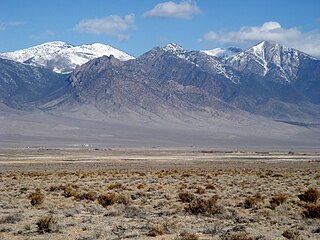
The Deep Creek Range, (often refereed to as the Deep Creek Mountains, are a mountain range in the Great Basin located in extreme western Tooele and Juab counties in Utah, United States. The range trends north–south, and is composed of granite in its central highest portion. The valley to the east is Snake Valley, and to the west is Deep Creek Valley. Nearby communities include Callao, Utah to the east and the community of Ibapah and the lands of the Confederated Tribes of the Goshute Reservation to the west.

The Wah Wah Mountains are a north-south trending range in west-central Utah, part of the larger Basin and Range Province. It is bounded by Pine Valley to the west, Wah Wah Valley to the east, the Escalante Desert to the south, and on trend with the Confusion Range to the north. The Wah Wah Mountains are located in Beaver and Millard counties. State Route 21 bisects the range, crossing over Wah Wah Summit at about 6,500 feet (1,980 m) above sea level. Elevations range from about 6,000 feet (1,800 m) at the mountain front to 9,393 feet (2,863 m) in the southern Wah Wahs.

The House Range is a north-south trending mountain range in Millard County, of west-central Utah. The House Range was named in 1859 by James H. Simpson. It was named by Simpson because "...of its well-defined stratification and the resemblance of portions of its outline to domes, minarets, houses, and other structures."
Tule Valley is a valley in Millard County, Utah, United States.

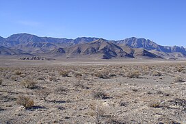
The Ferguson Desert is a small valley in the Hamlin-Snake Watershed of west-central Utah, southeast of the Snake Valley to the northwest, and is bound by the Burbank Hills to the west, the Tunnel Springs Mountains, Pine Valley, and Wah Wah Valley to the south, and the House Range to the north and east; Antelope Valley from the southwest is the southeast border of the Burbank Hills. It is named after James (Jim) Ferguson of Ibapah, Utah. He established a large ranch in the area. The term desert comes from the large hardpan that covers the area.

The Mountain Home Range is a north-south trending mountain range in western Beaver County in southwest Utah, United States. It is part of the Basin and Range Province. It is bound by Hamlin Valley to the west, Snake Valley to the north, Pine Valley to the east, and trends into the Indian Peak Range to the south. Collectively, the Mountain Home Range and Indian Peak Range are known as the Needle Mountains due to their jagged nature.

The Burbank Hills are a small northwest-southeast mountain range in western Utah, United States that lie entirely within the Hamlin-Snake Watershed, between the Snake Range and the Ferguson Desert. It is bounded by Snake Valley to the north, west, and south; and trends into the Tunnel Springs Mountains, to the southeast, opposite the Antelope Valley on its southeast border. It was named after the settlement of Burbank, Utah, and Margie Burbank Clay, the wife of local Judge E. W. Clay in the 1870s.
Hamlin Valley is a mostly north-south trending valley of the Great Basin located on both sides of the Nevada–Utah state line. It is about 60 miles (97 km) long. Its north-northeast end point adjacent the state line, is the southwest start region of the Snake Valley.

The Cricket Mountains are a 35-mile (56 km) long mountain range located in central-south Millard County, Utah, United States, on the east border of Sevier Lake, in the Great Basin Desert.
Deep Creek Valley is a 35-mile (56 km) long valley located in southwest Tooele County at the Utah-Nevada border; the extreme south of the valley is in northwest Juab County. The valley parallels the west flank of the Deep Creek Range, both north-trending. In the north-northeast, its outlet widens into the southwest of the Great Salt Lake Desert region.

The Lakeside Mountains are about a 34 miles (55 km) long mountain range located on the southwest perimeter of the Great Salt Lake; the range is located in northeast Tooele County and south Box Elder County in Utah, United States.

Pine Valley is a 50-mile (80 km) long valley in southwestern Utah, United States. Most of the valley lies in western Beaver and Millard counties; the extreme south of the valley arises in two mountain range regions in northwestern Iron County.
Swasey Mountain is the north section of the House Range of northwest Millard County, Utah, United States; the extreme north of Swasey Mountain extends into south Juab County.
Frisco Peak is a summit near the north‑center edge of Beaver County, Utah, United States.
South Mountains are a range of mountains primarily in White Pine County, Nevada and partially to the east in Juab County, Utah. The range is sometimes referred to as the Deep Creek Mountains, or the Ibenpah Mountains. The South Mountains are divided from the Kern Mountains to the south by Tippett Canyon on the west and Pleasant Valley to the east. They are divided from the Deep Creek Range to the east in Utah by Johnson Canyon, on the north, and by Water Canyon on the south. The range is bounded on the north by Spring Creek Flat and on the west by Antelope Valley.
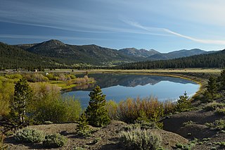
Hope Valley is a broad mountain valley in Alpine County, California, located on the eastern slope of the Sierra Nevada to the northeast of Carson Pass and south of Lake Tahoe. The valley served as a major thoroughfare for the passage of settlers and emigrants to and from California during the Gold Rush era. Sitting at an elevation of just above 7,000 feet (2,100 m) and framed by peaks reaching over 10,000 feet (3,000 m) high, Hope Valley is known for its wide vistas, fly fishing, fall colors, and winter activities.