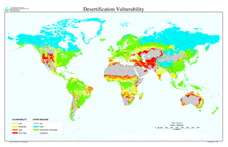
Desertification is a type of land degradation in drylands in which biological productivity is lost due to natural processes or induced by human activities whereby fertile areas become increasingly arid. It is the spread of arid areas caused by a variety of factors, such as climate change and overexploitation of soil as a result of human activity.

The Great Victoria Desert is a sparsely populated desert ecoregion and interim Australian bioregion in Western Australia and South Australia.
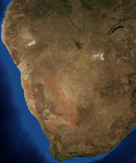
The Kalahari Desert is a large semi-arid sandy savanna in Southern Africa extending for 900,000 square kilometres (350,000 sq mi), covering much of Botswana, and parts of Namibia and South Africa.

Mongolia is a landlocked country in Central Asia and East Asia, located between China and Russia. The terrain is one of mountains and rolling plateaus, with a high degree of relief. The total land area of Mongolia is 1,564,116 square kilometres. Overall, the land slopes from the high Altai Mountains of the west and the north to plains and depressions in the east and the south. The Khüiten Peak in extreme western Mongolia on the Chinese border is the highest point. The lowest point is at 560 m (1,840 ft), is the Hoh Nuur or lake Huh. The country has an average elevation of 1,580 m (5,180 ft).

Deserts and xeric shrublands are a biome defined by the World Wide Fund for Nature. Deserts and xeric shrublands form the largest terrestrial biome, covering 19% of Earth's land surface area. Ecoregions in this habitat type vary greatly in the amount of annual rainfall they receive, usually less than 250 millimetres (10 in) annually except in the margins. Generally evaporation exceeds rainfall in these ecoregions. Temperature variability is also diverse in these lands. Many deserts, such as the Sahara, are hot year-round, but others, such as East Asia's Gobi, become quite cold in winter.

Rangelands are grasslands, shrublands, woodlands, wetlands, and deserts that are grazed by domestic livestock or wild animals. Types of rangelands include tallgrass and shortgrass prairies, desert grasslands and shrublands, woodlands, savannas, chaparrals, steppes, and tundras. Rangelands do not include forests lacking grazable understory vegetation, barren desert, farmland, or land covered by solid rock, concrete and/or glaciers.

The Gibson Desert is a large desert in Western Australia. and is still largely in an almost "pristine" state. It is about 155,000 square kilometres (60,000 sq mi) in size, making it the fifth largest desert in Australia, after the Great Victoria, Great Sandy, Tanami and Simpson deserts. The Gibson Desert is both an interim Australian bioregion and desert ecoregion.

The Syrian Desert, also known as the Syrian steppe, the Jordanian steppe, or the Badia, is a region of desert, semi-desert and steppe covering 500,000 square kilometers of the Middle East, including parts of south-eastern Syria, northeastern Jordan, northern Saudi Arabia, and western Iraq. It accounts for 85% of the land area of Jordan and 55% of Syria. To the south it borders and merges into the Arabian Desert. The land is open, rocky or gravelly desert pavement, cut with occasional wadis.

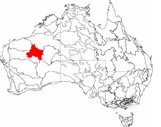
The Shire of Ngaanyatjarraku is a remote local government area in Western Australia near the Northern Territory/South Australian border. It is 1,542 km (958 mi) from Perth.
The Little Sandy Desert, an interim Australian bioregion, is a desert located in Western Australia south of the Great Sandy Desert and west of the Gibson Desert.
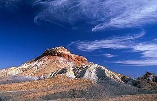
The Painted Desert is in the Far North of South Australia. It is 120 kilometres (75 mi) north-east of Coober Pedy, in the Arckaringa Station pastoral lease, not far from the homestead. It is notable for its distinctive mesas, mountains, and geological formations. Not far from here on the way to Oodnadatta, there are large areas of ground covered with mica. The entire region is desolate and made up of soft, fragile rock.

Munga-Thirri–Simpson Desert National Park, part of which was formerly Munga-Thirri–Simpson Desert Conservation Park, Simpson Desert Conservation Park, and Simpson Desert National Park, is a protected area located in the far north of the Australian state of South Australia, near its border with Queensland and the Northern Territory. As of November 2021 it is the largest national park in Australia, covering 3,600,000 ha (14,000 sq mi).

The named deserts of Australia cover 1,371,000 km2 (529,000 sq mi), or 18% of the Australian mainland, but about 35% of the Australian continent receives so little rain, it is effectively desert. The deserts in Australia are primarily distributed throughout the Western Plateau and interior lowlands of the country. The deserts in western Australia are well explained by the little evaporation of the cold sea current of the West Australian Current, of polar origin, which prevents significant rainfall in the interior of the continent.

The Gascoyne River is a river in the Gascoyne region of Western Australia. At 865 kilometres (537 mi), it is the longest river in Western Australia.
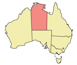
The Northern Territory (NT) occupies the north central part of the continent of Australia. The Northern Territory borders are to the west with Western Australia, the Western Australia border being near the 129° east longitude. The NT to the south with the South Australian border being the 26th parallel south latitude. To the east the NT with the Queensland border along the 138° east longitude.

The Tirari Desert is a 15,250 square kilometres (5,888 sq mi) desert in the eastern part of the Far North region of South Australia. It stretches 212 km from north to south and 153 km from east to west.

A desert is a barren area of landscape where little precipitation occurs and, consequently, living conditions are hostile for plant and animal life. The lack of vegetation exposes the unprotected surface of the ground to the processes of denudation. About one-third of the land surface of the Earth is arid or semi-arid. This includes much of the polar regions, where little precipitation occurs, and which are sometimes called polar deserts or "cold deserts". Deserts can be classified by the amount of precipitation that falls, by the temperature that prevails, by the causes of desertification or by their geographical location.

Centre points of Australia are those geographical locations that have been considered to be centre of Australia, as distinct from the extreme points of Australia.

Cogla Downs Station is a pastoral lease and sheep station located in the Mid West region of Western Australia.

Lambina Station is a pastoral lease that once operated as a sheep station but now operates as a cattle station in outback South Australia.
