
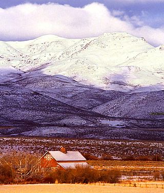
Elko County is a county in the northeastern corner of Nevada, United States. As of the 2020 census, the population was 53,702. Its county seat is Elko. The county was established on March 5, 1869, from Lander County. Elko County is the fourth-largest county by area in the contiguous United States, ranking lower when the boroughs of Alaska are included. It is one of only 10 counties in the U.S. with more than 10,000 square miles (25,900 km2) of area. Elko County is the second-largest county by area in Nevada, with only Nye County being larger. Elko County is part of the Elko micropolitan statistical area. It contains 49.8 percent of the Duck Valley Indian Reservation, set up in the late 19th century for the Shoshone-Paiute peoples; they are a federally recognized tribe. Although slightly more than 50% of the reservation is across the border in Owyhee County, Idaho, the majority of tribal members live on the Nevada side. The reservation's land area is 450.391 square miles (1,166.5 km2).
Owyhee County is a county in the southwestern corner of the U.S. state of Idaho. As of the 2020 census, the population was 11,913. The county seat is Murphy, and its largest city is Homedale. In area it is the second-largest county in Idaho, behind Idaho County. Owyhee County is part of the Boise metropolitan area and contains slightly more than half of the Duck Valley Indian Reservation, which extends over the Nevada border, into Elko County. The majority of the federally recognized Shoshone-Paiute Tribe that is associated with this reservation lives on the Nevada side; its tribal center is in Owyhee, Nevada.

Elmore County is a county in the U.S. state of Idaho. As of the 2020 census, the population was 28,666. The largest city and county seat is Mountain Home.

Boise County is a rural mountain county in the U.S. state of Idaho. As of the 2020 United States Census, the population was 7,610. The county seat is historic Idaho City, which is connected through a series of paved and unpaved roads to Lowman, Centerville, Placerville, Pioneerville, Star Ranch, Crouch, Garden Valley, and Horseshoe Bend.
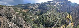
The Bruneau River is a 153-mile-long (246 km) tributary of the Snake River in the western United States, located in Idaho and Nevada. It runs through a narrow canyon cut into ancient lava flows in southwestern Idaho. The Bruneau Canyon, which is up to 1,200 feet (370 m) deep and forty miles (65 km) long, features rapids and hot springs, making it a popular whitewater trip.

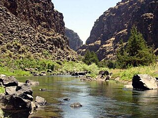
The Owyhee River is a tributary of the Snake River located in northern Nevada, southwestern Idaho and southeastern Oregon in the Western United States and its Pacific Northwest region. It is 280 miles (450 km) long. The river's drainage basin is 11,049 square miles (28,620 km2) in area, one of the largest subbasins of the Columbia River Basin with its major waterways of the Columbia River and Snake River. The mean annual discharge is 995 cubic feet per second (28.2 m3/s), with a maximum of 50,000 cu ft/s (1,400 m3/s) recorded in 1993 and a minimum of 42 cu ft/s (1.2 m3/s) in 1954.

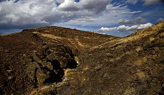
The Jarbidge River is a 51.8-mile-long (83.4 km), high elevation river in Elko County, Nevada, and Owyhee County, Idaho, in the United States. The Jarbidge originates as two main forks in the Jarbidge Mountains of northeastern Nevada and then flows through basalt and rhyolite canyons on the high plateau of the Owyhee Desert before joining the Bruneau River.
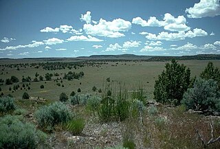
The Oregon High Desert is a region of the U.S. state of Oregon located east of the Cascade Range and south of the Blue Mountains, in the central and eastern parts of the state. Divided into a southern region and a northern region, the desert covers most of five Oregon counties and averages 4,000 feet (1,200 m) above sea level. The southwest region is part of the Great Basin and the southeast is the lower Owyhee River watershed. The northern region is part of the Columbia Plateau, where higher levels of rainfall allow the largest industry on private land to be the cultivation of alfalfa and hay. Public land within the region is owned primarily by the Bureau of Land Management, which manages more than 30,000 square miles (78,000 km2) including five rivers designated as Wild and Scenic.

The Northern Basin and Range ecoregion is a Level III ecoregion designated by the United States Environmental Protection Agency (EPA) in the U.S. states of Oregon, Idaho, Nevada, Utah, and California. It contains dissected lava plains, rolling hills, alluvial fans, valleys, and scattered mountain ranges in the northern part of the Great Basin. Although arid, the ecoregion is higher and cooler than the Snake River Plain to the north and has more available moisture and a cooler climate than the Central Basin and Range to the south. Its southern boundary is determined by the highest shoreline of Pleistocene Lake Bonneville, which once inundated the Central Basin and Range. The western part of the region is internally drained; its eastern stream network drains to the Snake River system.

The Trout Creek Mountains are a remote, semi-arid Great Basin mountain range mostly in southeastern Oregon and partially in northern Nevada in the United States. The range's highest point is Orevada View Benchmark, 8,506 feet (2,593 m) above sea level, in Nevada. Disaster Peak, elevation 7,781 feet (2,372 m), is another prominent summit in the Nevada portion of the mountains.
The Bruneau – Jarbidge Rivers Wilderness is located on the high basalt plateaus of Owyhee County in southwestern Idaho in the western United States. The wilderness area is named after and protects much of the Bruneau and Jarbidge Rivers and their canyons. Whitewater rafting is a popular recreational activity in this wilderness area, which has rivers up to Class V. About 40 miles (64 km) of the Bruneau River and about 28.8 miles (46.3 km) of the Jarbidge River are classified as a wild river.

The Owyhee River Wilderness is located on the high basalt plateaus of Owyhee County in southwestern Idaho in the western United States. The wilderness area is named after and protects the upper Owyhee River, its tributaries, and the surrounding desert canyon landscape. Whitewater rafting is a popular recreational activity in this wilderness area. Managed by the Bureau of Land Management, it is the second-largest U.S. Wilderness Area that is not located within a National Forest, National Park, or National Wildlife Refuge. The BLM's Black Rock Desert Wilderness, located within Black Rock Desert – High Rock Canyon Emigrant Trails National Conservation Area, is larger. About 67.3 miles (108.3 km) of the Owyhee River is classified as a wild river.
Dickshooter is the name of a trailmarker and also of at least three features in Owyhee County, Idaho: a ridge, a reservoir, and a creek. These are in close proximity to each other in the southwestern corner of the state, in a wilderness area approximately 24 miles (39 km) northwest of Riddle.

The Pole Creek Wilderness is located on the high rhyolite and basalt plateaus of Owyhee County in southwestern Idaho in the western United States. Its whitewater rapids are a popular attraction.
The North Fork Owyhee Wilderness is on the high basalt plateaus of Owyhee County in southwestern Idaho in the western United States. The rivers within it offer whitewater rapids up to Class IV. The upper 20.8 miles (33.5 km) of the North Fork Owyhee River, from the Idaho–Oregon border to the upstream boundary of the wilderness, are part of the National Wild and Scenic Rivers System. Of this total, 15.1 miles (24.3 km) are classified as wild and the remaining 5.7 miles (9.2 km) are classified "recreational".

The Big Jacks Creek Wilderness is located on the high basalt plateaus of Owyhee County in southwestern Idaho in the western United States. Little Jacks Creek Wilderness is on its northwest border. About 35 miles (56 km) of Big Jacks Creek is classified as a wild river.

The Little Jacks Creek Wilderness is located on the high basalt plateaus of Owyhee County in southwestern Idaho in the western United States. Big Jacks Creek Wilderness is on its southeast border. About 12.4 miles (20.0 km) of Little Jacks Creek is classified as a wild river.

Battle Creek is a 67-mile (110 km) long tributary of the Owyhee River. Beginning at an elevation of 6,704 feet (2,043 m) in central Owyhee County, Idaho, it flows generally south through the Owyhee Desert to its mouth west of Riddle, at an elevation of 4,636 feet (1,413 m). In 2009, 23.4 miles (37.7 km) of the creek were designated as wild by the Omnibus Public Land Management Act, which also created the Owyhee River Wilderness.

Sheep Creek is a 63-mile (101 km) long tributary of the Bruneau River. Beginning at an elevation of 6,126 feet (1,867 m) east of Owyhee in northern Elko County, Nevada, it flows generally north into Owyhee County, Idaho and the Owyhee Desert, where it is roughly paralleled by Idaho State Highway 51. It then flows to its mouth in the Bruneau – Jarbidge Rivers Wilderness, at an elevation of 3,415 feet (1,041 m). In 2009, 25.6 miles (41.2 km) of the creek were designated as wild by the Omnibus Public Land Management Act, which also created the Bruneau – Jarbidge Rivers Wilderness.
Big Jacks Creek is a 58-mile (93 km) long tributary of Jacks Creek in Owyhee County, Idaho. Beginning at an elevation of 5,935 feet (1,809 m) north of Riddle, it flows generally north and slightly east through the arid Big Jacks Creek Wilderness, before reaching its mouth southwest of Bruneau, at an elevation of 2,779 feet (847.0 m). In 2009, 35.0 miles (56.3 km) of the creek were designated as wild by the Omnibus Public Land Management Act, which also created the Big Jacks Creek Wilderness.
