maximum extent of Glacial Lake Missoula (eastern) and Glacial Lake Columbia (western)
areas swept by Missoula and Columbia floods
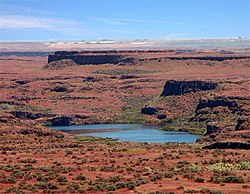
The Channeled Scablands are a relatively barren and soil-free region of interconnected relict and dry flood channels, coulees and cataracts and the typically flat-lying basalt flows that remain after cataclysmic floods.[1][2] They are located in the southeastern part of Washington state. The Channeled Scablands were scoured by more than 40 cataclysmic floods during the Last Glacial Maximum and innumerable older cataclysmic floods over the last two million years.[3][4][5] These floods were periodically unleashed whenever a large glacial lake broke through its ice dam and swept across eastern Washington and down the Columbia River Plateau during the Pleistoceneepoch. The last of the cataclysmic floods occurred between 18,200 and 14,000 years ago.[6] The floods eroded the area into the Palouse loess.
GeologistJ Harlen Bretz defined "scablands" in a series of papers written in the 1920s as lowlands diversified by a multiplicity of irregular channels and rock basins eroded into basalt. Flood waters eroded the loess cover, creating large anastomizing channels that exposed bare basalt and creating butte-and-basin topography. The buttes range in height from 30 to 230m (98 to 755ft), while the rock basins range from 10m (33ft) in width up to the 11km (7mi) long and 30m deep Rock Lake. Bretz further stated, "The channels run uphill and downhill, they unite and they divide, they head on the back-slopes and cut through the summit; they could not be more erratically and impossibly designed."[7]
The debate on the origin of the Scablands that ensued for four decades became one of the great controversies in the history of earth science. The Scablands are also important to planetary scientists as perhaps the best terrestrial analog of the Martian outflow channels.[8][pageneeded][9][10]
History
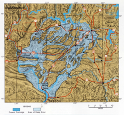
Map of the Channeled Scablands
Bretz conducted research and published many papers during the 1920s describing the Channeled Scablands. His theories of how they were formed required short but immense floods–500 cubic miles (2,100km3)–for which Bretz had no explanation. His theories of apparent catastrophism met with vehement opposition from geologists of the day, who tried to explain the features with uniformitarian theories–that they were shaped by processes still acting today.[11]
J. T. Pardee first suggested in 1925 to Bretz that the draining of a glacial lake could account for flows of the magnitude needed. Pardee continued his research over the next 30 years, collecting and analyzing evidence that eventually identified Lake Missoula as the source of the floods (now the Missoula floods) and creator of the Channeled Scablands.[12]
Pardee's and Bretz's theories were accepted only after decades of painstaking work and fierce scientific debate. Research on open-channel hydraulics in the 1970s put Bretz's theories on solid scientific ground. In 1979 Bretz received the highest medal of the Geological Society of America, the Penrose Medal, to recognize that he had developed one of the great ideas in the earth sciences.[13]
The term scabland refers to an area that has experienced fluvial erosion resulting in the loss of loess and other soils, leaving the land barren.[14]River valleys formed by erosional downcutting of rivers create V-shaped valleys, while glaciers carve out U-shaped valleys. The Channeled Scablands have a rectangular cross section, with flat plateaus and steep canyon sides, and are spread over immense areas of eastern Washington. The morphology of the scablands is butte-and-basin.[14] The area that encompasses the Scablands has been estimated between 1,500 and 2,000 square miles (3,900 and 5,200km2), though those estimates still may be too conservative.[15]
They exhibit a unique drainage pattern that appears to have an entrance in the northeast and an exit in the southwest. The Cordilleran ice sheet dammed up Glacial Lake Missoula at the Purcell Trench Lobe.[15] A series of floods occurring over the period of 18,000 to 13,000 years ago swept over the landscape when the ice dam broke. The eroded channels also show an anastomosing, or braided, appearance.
The presence of Middle and Early Pleistocene Missoula flood deposits have been documented within the Channeled Scabland as other parts of the Columbia Basin, e.g. the Othello Channels, Columbia River Gorge, Quincy Basin, Pasco Basin, and the Walla Walla Valley. Based on the presence of multiple interglacialcalcretes interbedded with glaciofluvial flood deposits, magnetostratigraphy, optically stimulated luminescence dating, and unconformity truncated clastic dikes, it has been estimated that the oldest of these megafloods flowed through the Channel Scablands sometime before 1.5 million years ago. Because of the fragmentary nature of older glaciofluvial deposits, which have been largely removed by subsequent Missoula floods, the exact number of older Missoula floods, which are known as Ancient Cataclysmic Floods, that occurred during the Pleistocene cannot be estimated with any confidence.[3][4] As many as 100 separate, cataclysmic Ice Age floods may have occurred during the last glaciation.[16] There have been at least 17 complete interglacial-glacial cycles since about 1.77 million years ago, and perhaps as many as 44 interglacial-glacial cycles since the beginning of the Pleistocene about 2.58 million years ago. Presuming a dozen (or more) floods were associated with each glaciation, the total number of cataclysmic Ice Age Missoula floods that flowed through the Channeled Scablands for the entire Pleistocene Epoch could possibly number in the hundreds, perhaps exceeding a thousand Ancient Cataclysmic Floods.[5]
There are also immense potholes and ripple marks, much larger than those found on ordinary rivers. When these features were first studied, no known theories could explain their origin. The giant current ripples are between 3 and 49 feet (1 and 15m) high and are regularly spaced, relatively uniform hills.[14] Vast volumes of flowing water would be required to produce ripple marks of this magnitude, as they are larger-scale versions of the ripple marks found on streambeds that are typically only centimeters high. Large potholes were formed by swirling vortexes of water called kolks scouring and plucking out the bedrock.[15]
The Scablands are littered with large boulders called glacial erratics that rafted on glaciers and were deposited by the glacial outburst flooding. The lithology of erratics usually does not match the rock type that surrounds it, as they are often carried very far from their origin.[15]
See also
Wallula Gap– Large water gap of the Columbia River through basalt anticlines in the U.S. state of Washington
Grand Coulee– Ancient river bed in the U.S. state of Washington
Moses Coulee– Canyon in the Waterville plateau region of Douglas County, Washington
Lake Lenore (Washington)– Lake formed by the Missoula Floods in the lower Coulee in Washington state
Glacial lake outburst flood– Type of outburst flood that occurs when the dam containing a glacial lake fails
↑ Bjornstad, B.; Kiver, E. (2012). On the Trail of the Ice Age Floods: The Northern Reaches: A geological field guide to northern Idaho and the Channeled Scabland. Sandpoint, Idaho: Keokee Books. ISBN978-1879628397.
↑ Neuendorf, K.K.E., J.P. Mehl, Jr., and J.A. Jackson, eds. (2005) Glossary of Geology (5th ed.). Alexandria, Virginia, American Geological Institute. 779 pp. ISBN0-922152-76-4
1 2 Medley, E. (2012). Ancient Cataclysmic Floods in the Pacific Northwest: Ancestors to the Missoula Floods (Thesis). Portland, Oregon: Unpublished Masters thesis, Portland State University.
1 2 Spencer, P. K.; Jaffee, M. A. (2002). "Pre-Late Wisconsinan Glacial Outburst Floods in Southeastern Washington—The Indirect Record". Washington Geology. 30 (1/2): 9–16.
1 2 Bjornstad, B. (2002). Standardized Stratigraphic Nomenclature for Post-Ringold-Formation Sediments Within the Central Pasco Basin. Report DOE/RL-2002-39 Rev. 0. Richland, Washington: Pacific Northwest National Laboratory, US Department of Energy.
1 2 Baker, Victor (2010). Migoń, Piotr (ed.). Channeled Scablands: A Megaflood Landscape, in Geomorphological Landscapes of the World. Springer. pp.21–28. ISBN9789048130542.
↑ Carr, M. H. (2006), The Surface of Mars. Cambridge Planetary Science Series, Cambridge University Press.
↑ Carr, Michael H. “The Geology of Mars: Volcanic, Tectonic, and Fluvial Features on the Surface of Mars Record a Long and Varied Geologic History.” American Scientist 68, no. 6 (1980): 626–35. http://www.jstor.org/stable/27850131.
↑ Baker, V. R., and D. J. Milton. 1974. Erosion by catastrophic floods on Mars. Icarus 23:27-41
↑ Bretz, J. Harlen. The Channeled Scabland. United States: U.S. Government Printing Office, 1932.
↑ Waitt, RB, Jr. (1994) Scores of Gigantic, Successively Smaller Lake Missoula Floods Through Channeled Scabland and Columbia Valley, in Geologic Field Trips in the Pacific Northwest: 1994 Geological Society of America Meeting, Chapter 1K, D. A. Swanson and R. A. Haugerud (eds.), Geological Society of America, Boulder, Colorado.
Additional references
Allen, John Eliot; Burns, Marjorie; Sargent, Sam C. (1986). Cataclysms on the Columbia. Portland, Oregon: Timber Press. ISBN0-88192-215-3.
Bretz, J.; Smith, H. T.; Neff, G. E. (1956). "Channeled Scabland of Washington: New Data and Interpretations". Geological Society of America Bulletin. 67 (8): 957–1049. doi:10.1130/0016-7606(1956)67[957:CSOWND]2.0.CO;2.
Soennichsen, John (2008). Bretz's Flood: The Remarkable Story of a Rebel Geologist and the World's Greatest Flood. Seattle, Washington: Sasquatch Books. ISBN978-1-57061-505-4.
This page is based on this Wikipedia article Text is available under the CC BY-SA 4.0 license; additional terms may apply. Images, videos and audio are available under their respective licenses.