Alameda Ridge

Last updated
Homes on the Alameda Ridge, Alameda Neighborhood. Alameda01.jpg
Homes on the Alameda Ridge, Alameda Neighborhood.

The Alameda Ridge is a large gravel bar located in Portland, Oregon, United States.

Contents

Geologic history

Alameda Ridge was formed between 15,000 and 13,000 years ago at the end of the last ice age when the ice dam containing Glacial Lake Missoula collapsed some 40 times, causing the Missoula Floods, some of the largest floods known on earth. The flood waters spilled across Idaho and eastern Washington, surged down the Columbia River and through the Gorge, flooding the Willamette Valley as far south as Eugene, Oregon. These floods covered the city of Portland, Oregon in approximately 400 feet (120 m) of water, carving out Sullivan's Gulch, the large ravine that holds Interstate 84, and depositing large volumes of unconsolidated silt, sand, gravel, and boulders. [1] [2] As the west-flowing waters rushed around Rocky Butte, a volcanic cinder cone in the Boring Lava Field, sediments were deposited on the west side of the butte forming an approximately 100 to 150-foot (46 m) high bar that became Alameda Ridge. The ridge extends west roughly 6 miles (9.7 km) from Rocky Butte to approximately 15th Avenue and Skidmore Street.

Human history

Rocky Butte from the east. Rocky butte from I-205 2003.jpg
Rocky Butte from the east.

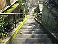
Portland residents began building on Alameda Ridge around the turn of the 20th century, as electric streetcars allowed real estate development to grow away from the city core. The steep hillside on the south side of the ridge provides beautiful views of Northeast Portland and the downtown skyline. This allowed early developers to cater to wealthy individuals. [3] [4] Because the Ridge was developed before cars were the primary mode of transportation, many public stairways were built along the southern hillside to allow easier travel between neighborhoods. [5] These stairways are still present today and are maintained by the City of Portland. Alameda Ridge runs through the Madison South, Roseway, Rose City Park, Beaumont-Wilshire, Alameda, and Sabin Neighborhoods, with some of the most expensive homes (some being worth more than one million dollars) located along the upper edge of the southern slope in the Rose City Park, Beaumont, Alameda Neighborhoods. A growing concern among locals is the present-day removal or renovation of long-existing structures due to the need to repair them as well as the pressure to conform to more modern styles of living. [6]

Related Research Articles

Missoula floods Cataclysmic floods at the end of the last ice age, in eastern Washington state, US

The Missoula floods were cataclysmic glacial lake outburst floods that swept periodically across eastern Washington and down the Columbia River Gorge at the end of the last ice age. These events have been researched since the 1920s. These were the result of periodic sudden ruptures of the ice dam on the Clark Fork River that created Glacial Lake Missoula. After each ice dam rupture, the waters of the lake would rush down the Clark Fork and the Columbia River, flooding much of eastern Washington and the Willamette Valley in western Oregon. After the rupture, the ice would reform, creating Glacial Lake Missoula again.

Lake Missoula Prehistoric proglacial lake in Western Montana

Lake Missoula was a prehistoric proglacial lake in western Montana that existed periodically at the end of the last ice age between 15,000 and 13,000 years ago. The lake measured about 7,770 square kilometres (3,000 sq mi) and contained about 2,100 cubic kilometres (500 cu mi) of water, half the volume of Lake Michigan.

Channeled Scablands Landscape in eastern Washington, USA scoured by cataclysmic floods during the Pleistocene epoch

The Channeled Scablands at one time were a relatively barren and soil-free region of interconnected relict and dry flood channels, coulees and cataracts eroded into Palouse loess and the typically flat-lying basalt flows that remain after cataclysmic floods within the southeastern part of the U.S. state of Washington. The channeled scablands were scoured by more than 40 cataclysmic floods during the Last Glacial Maximum and innumerable older cataclysmic floods over the last two million years. These cataclysmic floods were repeatedly unleashed when a large glacial lake repeatedly drained and swept across eastern Washington and down the Columbia River Plateau during the Pleistocene epoch. The last of the cataclysmic floods occurred between 18,200 and 14,000 years ago.

Klickitat Street

Klickitat Street is a city street located in northeast Portland, Oregon, United States. The main stem of the street is 3.75-mile (6.04 km) long, and runs east-west parallel to—and one block south of—northeast Fremont Street, from the eastern edge of Irving Park to Northeast 67th Avenue. Additional disconnected segments are east of Rocky Butte from 105th to 117th, 148th to 154th, and 163rd to 165th. A segment named Klickitat Court is between 135th and 140th.

View Ridge, Seattle

View Ridge is a neighborhood in north Seattle, Washington. As with all Seattle neighborhoods, its boundaries are not fixed, but can be thought of as NE 65th Street in the south, 40th and 45th Avenues NE in the west, the Sand Point Country Club in the north, and Sand Point Way NE in the east. Many homes offer views of Lake Washington, Mount Rainier, and the Cascade Range. View Ridge Elementary School is located within the neighborhood, and the neighborhood also offers a large park and playfield across the street from the elementary school. The View Ridge Swim and Tennis Club is located on the eastern edge of View Ridge, and the Sand Point Country Club is located on the northern edge.

Rocky Butte

Rocky Butte is an extinct cinder cone butte in Portland, Oregon, United States. It is also part of the Boring Lava Field, a group of volcanic vents and lava flows throughout Oregon and Washington state. The volcano erupted between 285,000 and 500,000 years ago.

Alameda, Portland, Oregon Neighborhood in Portland, Oregon, United States

Alameda is a neighborhood in Portland, Oregon, United States that is located on the Alameda Ridge with views of Downtown, the Willamette River, and the Cascades. Northeast Fremont Street is the neighborhood's main east-west thoroughfare and NE 33rd, its main north-south thoroughfare, makes up its eastern boundary. The neighborhood is adjacent to Wilshire Park, a 14.4-acre (58,000 m2) neighborhood park. The community's side streets wind around the hill, past cottages and expansive Craftsman homes. Alameda is located between the business districts of Beaumont Village and the Hollywood District. Locals informally refer to the neighborhood as the Yarn District for its abundance of yarn-based hobbyists.

Beaumont-Wilshire, Portland, Oregon Neighborhood in Portland, Oregon, United States

The Beaumont-Wilshire neighborhood of Portland, Oregon is located in the city's northeast section, on Alameda Ridge with views of Downtown, the Willamette River, and the Cascades. It is bordered by the Alameda, Concordia, Cully, Rose City Park, and Grant Park neighborhoods. "Beaumont Village", located on NE Fremont Street, from NE 33rd Ave. to NE 50th Ave., is the main commercial district in the neighborhood, but the neighborhood also lies within walking distance of the Hollywood District, a major commercial and shopping area to the south.

Irvington, Portland, Oregon Neighborhood in Portland, Oregon, United States

Irvington is a neighborhood in the Northeast section of Portland, Oregon. According to the city's Office of Community and Civic Life, it consists of a rectangular area extending east to west from NE 7th Ave. to NE 26th Ave., and north to south from NE Fremont St. to NE Broadway. It borders the King, Sabin, and Alameda neighborhoods to the north; Alameda and Grant Park to the east; Sullivan's Gulch and the Lloyd District to the south; and Eliot to the west.

Neighborhoods of Portland, Oregon

Portland, Oregon is divided into six sections, as of May 1, 2020: North Portland, Northeast Portland, Northwest Portland, South Portland, Southeast Portland, and Southwest Portland. There are 95 officially recognized neighborhoods, each of which is represented by a volunteer-based neighborhood association. No neighborhood associations overlap the Willamette River, but a few overlap the addressing sextants. For example, most addresses in the South Portland Neighborhood Association are South, but a portion of the neighborhood is west of SW View Point Terrace where addresses have a SW prefix. Similarly the Buckman Neighborhood Association spans both NE and SE Portland.

Concordia, Portland, Oregon Neighborhood in Portland, Oregon, United States

Concordia is a neighborhood in the Northeast section of Portland, Oregon, United States, named after Concordia University, which is located within it. The neighborhood borders are NE 22nd Ave. on the west, NE Columbia Blvd. on the north, and NE 42nd Ave. on the east. On the south, the border is NE Prescott St. and NE Alberta Ct., to the west and east of NE 33rd Ave., respectively. Neighborhoods bordering Concordia are Woodlawn, Vernon, and Sabin on the west, Sunderland on the north, Cully on the east, and Alameda and Beaumont-Wilshire on the south.

Rose City Park, Portland, Oregon Neighborhood in Portland, Oregon, United States

Rose City Park is a neighborhood in Northeast Portland, Oregon. It borders Beaumont-Wilshire, Grant Park, and the Hollywood District on the west, Cully on the north, Roseway and Madison South on the east, and Center on the south.

Sullivans Gulch, Portland, Oregon Neighborhood in Portland, Oregon, United States

Sullivan's Gulch is a neighborhood in the Northeast section of Portland, Oregon. The name commemorates Timothy Sullivan, an early farmer in the area. Sullivan settled his donation land claim on January 27, 1851. He was born in Ireland in 1805, received citizenship in the United States in 1855, and most likely received title to the claim around 1863.

Madison South, Portland, Oregon Neighborhood in Portland, Oregon, United States

Madison South is a neighborhood in the Northeast section of Portland, Oregon. It is bordered by the Roseway, Sumner, Cully, Parkrose, Montavilla, and Rose City Park neighborhoods, and by the enclave city of Maywood Park. The neighborhood roughly conforms to the boundaries of Interstate 84 to the south, Interstate 205 to the east, NE Sandy Boulevard to the north, and NE 65th Avenue to the west.

Touchet Formation

The Touchet Formation or Touchet beds consist of large quantities of gravel and fine sediment which overlay almost a thousand meters of volcanic basalt of the Columbia River Basalt Group in south-central Washington and north-central Oregon. The beds consist of between 6 and 40 distinct rhythmites – horizontal layers of sediment, each clearly demarcated from the layer below. These Touchet beds are often covered by windblown loess soils which were deposited later; the number of layers varies with location. The beds vary in depth from 330 ft (100 m) at lower elevations where a number of layers can be found to a few extremely thin layers at the maximum elevation where they are observed.

Johnson Creek (Willamette River tributary) Creek in Oregon, USA

Johnson Creek is a 25-mile (40 km) tributary of the Willamette River in the Portland metropolitan area of the U.S. state of Oregon. Part of the drainage basin of the Columbia River, its catchment consists of 54 square miles (140 km2) of mostly urban land occupied by about 180,000 people as of 2012. Passing through the cities of Gresham, Portland, and Milwaukie, the creek flows generally west from the foothills of the Cascade Range through sediments deposited by glacial floods on a substrate of basalt. Though polluted, it is free-flowing along its main stem and provides habitat for salmon and other migrating fish.

Ice Age Floods National Geologic Trail

The Ice Age Floods National Geologic Trail or Ice Age Floods Trail is designated as the first National Geologic Trail in the United States. It will consist of a network of routes connecting facilities that will provide interpretation of the geological consequences of the Glacial Lake Missoula floods of the last glacial period that began about 110,000 years ago.

Lake Allison

Lake Allison was a temporary lake in the Willamette Valley of Oregon, formed periodically by the Missoula Floods from 15,000 to 13,000 BC. The lake is the main cause of the rich and fertile soil that now characterizes the Willamette Valley.

Willamette Valley valley in the Pacific Northwest region of the United States

The Willamette Valley is a 150-mile (240 km) long valley in Oregon, in the Pacific Northwest region of the United States. The Willamette River flows the entire length of the valley, and it is surrounded by mountains on three sides – the Cascade Range to the east, the Oregon Coast Range to the west, and the Calapooya Mountains to the south.

Jump Off Joe (Washington)

Jump off Joe is a butte in the Horse Heaven Hills south of Kennewick in the U.S. State of Washington. Jump off Joe rises above the Tri-Cities and is visible throughout much of the region, including in parts of Umatilla and Morrow Counties in Oregon to the south. A gravel road approaches the summit from the south up a steep incline. On a clear day, visitors to the summit can see Mount Hood, Mount Adams and Mount Rainier.

References

  1. Waymarking.com - "Missoula Flood Glacial Erratic, Tualatin, Oregon"
  2. USGS Cascades Volcano Observatory
  3. "Transportation Climbs Out of the Mud and Into the Clouds" - Randy Gragg, the Oregonian, May 12, 2005.
  4. "Alameda Ridge Bike Cruise" - Urban Adventure League, self-published
  5. "The Stairs of Alameda Ridge" - TatooineSky, YouTube Video.
  6. Decker, Doug (May 23, 2015). "Tear down on Alameda Ridge" (Web article). alamedahistory.org. Retrieved 2 February 2021.

Coordinates: 45°32′42″N122°33′58″W / 45.54500°N 122.56611°W / 45.54500; -122.56611