
The Muggins Mountains is a mountain range in southwest Arizona east of Yuma, Arizona, northeast of the Gila Mountains, and east of the Laguna Mountains. The Castle Dome Mountains lie to the northeast across the broad Castle Dome Plain. The Muggins Mountains Wilderness occupies the southwest portion of the range.

The Tank Mountains are a mountain range in the Sonoran Desert of southwest Arizona; the range is part of the southeastern border of the Kofa National Wildlife Refuge.

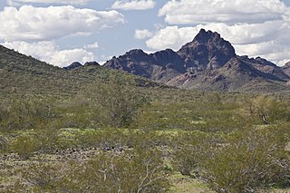
The Gila Mountains of Yuma County are a 26-mile (42 km) long mountain range in southwestern Arizona in the northwest Sonoran Desert.

The Altar Valley is a 45-mile (72 km) long north–south valley, trending slightly northeast from Sasabe, Arizona on the Mexico border to the Avra Valley west of the Tucson Mountains. It is delimited by Arizona State Route 86, from east-to-west on the north separating it from the Avra Valley which then trends northwesterly, merging into the plains and drainage of the Santa Cruz River.
The Harcuvar Mountains are a narrow mountain range in western-central Arizona, United States. The range lies just east of the north-south Colorado River, and south of the east-west, west-flowing Bill Williams River, from Alamo Lake.

The Buckskin Mountains is a mountain range in La Paz County, Arizona, United States. The range lies just east of the north–south Colorado River, and borders south of the east–west, west-flowing Bill Williams River.
Sugarloaf Mountain, of Arizona is the tallest peak in the arid, low elevation Hummingbird Springs Wilderness of northwest Maricopa County, and about 65 miles (105 km) west of Phoenix. It rises in the Tonopah Desert about 10 miles (16 km) northwest of the Belmont Mountains. Hummingbird Springs Wilderness is just north of the Big Horn Mountains Wilderness. The two are separated only by a jeep trail that leads to Hummingbird Springs.

The Hummingbird Springs Wilderness is a 31,200-acre (12,626 ha) wilderness administered by the Bureau of Land Management (BLM). The wilderness is located in the northwest of Maricopa County in northern regions of the central Sonoran Desert of Arizona.
The Little Harquahala Mountains are a small, arid, low-elevation mountain range of western-central Arizona, in the southeast of La Paz County.

The Granite Wash Mountains are a short, arid, low elevation mountain range of western-central Arizona, in the southeast of La Paz County. The range borders a slightly larger range southeast, the Little Harquahala Mountains; both ranges form a section on the same water divide between two desert washes. The washes flow in opposite directions, one northwest to the Colorado River, the other southeast to the Gila River.

The Gila Bend Mountains are a 35-mile (56 km) long mountain range of the north-central Sonoran Desert southwest of Phoenix, Arizona and in southwest Maricopa County.
The Belmont Mountains are a 25 mi (40 km) long, arid, low elevation mountain range about 50 mi west of Phoenix, Arizona in the northern Sonoran Desert, north of the Gila River. The range is in the south of a region of two parallel washes; the Bouse Wash flows northwest to the Colorado River, and the Centennial Wash flows southeast to meet the Gila River.

The Big Burro Mountains are a moderate length 35-mile (56 km) long, mountain range located in central Grant County, New Mexico. The range's northwest-southeast 'ridgeline' is located 15 mi southwest of Silver City.

The 100,600-acre (407 km2) Eagletail Mountains Wilderness is part of the Eagletail Mountains of central-west Arizona, about 65 mi west of Phoenix. The wilderness is of moderate size, with the Eagletail Mountains forming its northeast perimeter, and the much shorter Cemetery Ridge section, forming its southwest border. The wilderness covers nearly all of the Eagletail Mountains and the plains on its southwest. The wilderness lies at the southeast of the Ranegras Plain, the headwater region of Bouse Wash, and lies adjacent to the northwest border of the extensive Gila Bend Mountains, the mountain range causing the great Gila Bend excursion of the Gila River, in Arizona.
The Date Creek Mountains are a short, arid range in southwest Yavapai County, Arizona. Congress is on its southeast foothills, and Wickenburg lies 15 mi (24 km) southeast.

The New River Mountains are a small 14-mi (23 km) long, mountain range in central Arizona, and on the north border of the Phoenix valley; the range is located on the southwest perimeter of the Arizona transition zone. The range is a sub-part of landforms extending south from the Black Hills of Yavapai County. Rivers and canyons border east and west; the south of the range is located in Maricopa County, the location of much of the Phoenix metropolitan area.

Yellow Knolls, of Arizona, is a prominence in the Virgin River Gorge's east end, located in Mohave County, part of the Arizona Strip of northwest Arizona. Yellow Knolls is located on the north side of Interstate 15, and is also in the south of the Beaver Dam Mountains Wilderness.

The Vulture Mountains is a 29-mile (47 km) long, arid, low-elevation mountain range located in northwest Maricopa County, Arizona, United States. It is in the north perimeter region of the Sonoran Desert. The Arizona transition zone mountain ranges lie north and northeast, just north of Wickenburg, Arizona. The Yarnell Hill, about 14 miles (23 km) north of Wickenburg, rising into the Weaver Mountains to Yarnell, marks the dramatic elevation rise from the desert. It is also a viewpoint southwest and southeast of the desert regions, including the Vulture Mountains.

The Toroweap Fault of northwest Arizona and southwest Utah is part of a fault system of the west Grand Canyon region, Arizona, US; also the west perimeter regions of the Coconino and Colorado Plateaus. The Hurricane Fault originates at the Toroweap Fault, in the region of the Colorado River, and strikes as the westerly depression of the Toroweap Fault. The Toroweap strikes northerly from the Colorado at the east of Toroweap Valley, and enters south Utah; from the Colorado River, the Hurricane Fault strikes north-northwest along the west flank of the small, regional Uinkaret Mountains, the west border of Toroweap Valley. The Hurricane Fault, and the Hurricane Cliffs strike into southwest Utah as part of the west, and southwest perimeter of the Colorado Plateau. The Hurricane Cliffs are made of Kaibab Limestone, an erosion resistant, cliff-forming rock unit.
