Ridgway is a village in Gallatin County, Illinois, United States. As of the 2020 census, the population was 851. As of 2018, Rebecca Mitchell was the town mayor.

East Highland Park is a census-designated place (CDP) in Henrico County, Virginia, in the United States. The population was 15,131 at the 2020 census.

Yoshikazu Taru is a Japanese professional wrestler, better known simply as Taru. He is currently signed to Makai, while also working for Pro Wrestling Zero1 (Zero1) and All Japan Pro Wrestling (AJPW), where he is the leader of the Voodoo Murders. He also previously worked in Diamond Ring, Wrestle Association R (WAR) and Toryumon Japan, later known as Dragon Gate (DG).

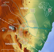
Kajiado County is a county in the former Rift Valley Province of Kenya. As of 2019, Kajiado county spanned an area of 21,292.7 km2, with a recorded population of 1,117,840. The county borders Nairobi and to its south it borders the Tanzanian regions of Arusha and Kilimanjaro. The county capital is Kajiado, but the largest town is Ongata Rongai. Its main tourist attraction is its wildlife.

Cajueiro is a municipality located in the western of the Brazilian state of Alagoas. Its population is 21,331 (2020) and its area is 124 km². Its name comes from the Portuguese for the cashew tree — in the 19th century, a village began to form around such a tree, near the banks of the Paraíba river.
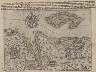
Kola Bay or Murmansk Fjord is a 57-km-long fjord of the Barents Sea that cuts into the northern part of the Kola Peninsula. It is up to 7 km wide and has a depth of 200 to 300 metres. The Tuloma, Rosta and Kola Rivers discharge into the bay.
Andreyevka is a village in the Jalilabad Rayon of Azerbaijan.
Thái Đào is a commune (xã) and village in Lạng Giang District, Bắc Giang Province, in northeastern Vietnam.

Sant Gervasi – Galvany is a neighborhood in the Sarrià-Sant Gervasi district of Barcelona, Catalonia (Spain). The name of the neighborhood refers to Sant Gervasi de Cassoles, which was one of the parts of the former municipality of Sant Gervasi de Cassoles; and the Camp d'en Galvany urbanization which was begun in 1866 by its owner, Joseph Galvany Castelló. The Galvany name became popular when the market Galvany was built, located between the neighborhood streets Santaló, Calaf, Amigó and Madrazo, and the market has a plaque on the facade of Santaló street recalling that Josep Galvany Castelló gave the land on which the market was built to the municipality.

Bennettville is a former settlement and ghost town in Mono County, California. It was located on Mine Creek 4 mi (6.4 km) east-southeast of Mount Conness.
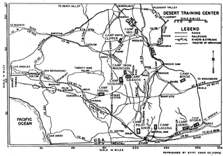
The Desert Training Center (DTC), also known as California–Arizona Maneuver Area (CAMA), was a World War II training facility established in the Mojave Desert and Sonoran Desert, largely in Southern California and Western Arizona in 1942.
Prelovo is a village in the municipality of Višegrad, Bosnia and Herzegovina.
Gornji Drežanj is a village in the municipality of Nevesinje, Republika Srpska, Bosnia and Herzegovina.

The Riiser-Larsen Peninsula is a large peninsula which forms the western portal to Lützow-Holm Bay and marks the separation of the Princess Ragnhild and Prince Harald Coasts. It was named after Captain Hjalmar Riiser-Larsen who discovered the peninsula in a flight from the Norvegia on 21 February 21 1931.
Mtsambama is an inkhundla of Eswatini, located in the Shiselweni District. Its population as of the 2007 census was 18,900. The chiefdoms or imiphakatsi falling under Mtsambama are KaMbhoke, Bhanganoma, Ekwendzeni, Magele and Gwegwe.

Belleville Air Force Station is a closed United States Air Force General Surveillance Radar station. It is located 2 miles (3.2 km) southeast of Belleville, Illinois. It was closed in 1968.

János Nyíri was a theatre director, journalist and writer. He wrote several highly acclaimed plays and novels, including Battlefields and Playgrounds, recognized by The Observer as the most important novel written by a survivor of the Holocaust.
Kajiado District was an administrative district in the Rift Valley Province of Kenya. It had a population of 406,054 and an area of 21,903 km². The district bordered Nairobi region and extended to the Kenya-Tanzania border further south. The district capital was Kajiado.