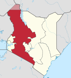
Rift Valley Province

Last updated
Rift Valley Province
Mkoa wa Bonde la Ufa
Rift Valley in Kenya.svg
Location in Kenya
Coordinates: 0°30′N36°0′E / 0.500°N 36.000°E / 0.500; 36.000
CountryFlag of Kenya.svg  Kenya
No. of Counties:14
Capital Nakuru
Area
  Total182,505.1 km2 (70,465.6 sq mi)
Population
 (2009)
  Total10,006,805
  Density55/km2 (140/sq mi)
Time zone UTC+3 (EAT)

Rift Valley Province (Swahili : Mkoa wa Bonde la Ufa) of Kenya, bordering Uganda, was one of Kenya's eight provinces, before the 2013 Kenyan general election. Rift Valley Province was the largest and one of the most economically important provinces in Kenya. It was dominated by the Kenya Rift Valley which passes through it and gives the province its name. According to the 2009 Census, the former province covered an area of 182,505.1 square kilometres (45,098,000 acres; 70,465.6 sq mi) and would have had a population of 10,006,805, [1] [2] making it the largest and most populous province in the country. The bulk of the provincial population inhabited a strip between former Nairobi and Nyanza Province. The capital was the town of Nakuru.

Contents

Counties

As of March 2013 after the Kenyan general election, 2013, the Province was partitioned into counties and Rift Valley Province was dissolved. [3]

CodeCountyFormer ProvinceArea (km2)Population
Census 2009
Capital
23 Turkana Rift Valley71,597.8855,399 Lodwar
24 West Pokot Rift Valley8,418.2512,690 Kapenguria
25 Samburu Rift Valley20,182.5223,947 Maralal
26 Trans Nzoia Rift Valley2,469.9818,757 Kitale
27 Uasin Gishu Rift Valley2,955.3894,179 Eldoret
28 Elgeyo-Marakwet Rift Valley3,049.7369,998 Iten
29 Nandi Rift Valley2,884.5752,965 Kapsabet
30 Baringo Rift Valley11,075.3555,561 Kabarnet
31 Laikipia Rift Valley8,696.1399,227 Nanyuki
32 Nakuru Rift Valley7,509.51,603,325 Nakuru
33 Narok Rift Valley17,921.2850,920 Narok
34 Kajiado Rift Valley21,292.7687,312 Kajiado
35 Kericho Rift Valley2,454.5752,396 Kericho
36 Bomet Rift Valley1,997.9730,129 Bomet
Totals182,505.110,006,805-

Geography

Map of Kenya, showing its provinces Kenya-relief-map-towns.jpg
Map of Kenya, showing its provinces

The Great Rift Valley runs south through Kenya from Lake Turkana in the north and has several unique geographical features, including the Elgeyo escarpment which is a popular tourist attraction.

Apart from the Rift Valley itself, the area has other important geographic features such as: the extinct volcanoes Mount Longonot and Mount Suswa and Lake Baringo, Lake Bogoria, Lake Magadi, Lake Nakuru, Lake Naivasha, the Suguta Valley, and Lake Turkana.

Geology

A large part of Kenya is underlain by Precambrian basement, while the Kenya rift basin (a typical extensional basin) hosts Tertiary volcanics that cover Mesozoic sediments (Recently these sediments have been considered for oil exploration). [4] The sedimentary basins evolved along the Anza trough during the Late Paleozoic to Early Tertiary times through extension tectonics during the major Gondwanaland breakup. In the Miocene Period, the region underwent intermittent uplift and subsidence along major boundary faults accompanied by a large outpouring of lava flows. The Anza trough intersects the modern rift valley in the area of Lake Turkana. Rifting still continues today; primarily in the north, where active volcanoes are more plentiful.

Economy

The highlands provide adequate rainfall for farming and agriculture which is the economic base of the residents of the Rift Valley. Tea from the highlands in the Kericho district enjoys a worldwide reputation, but horticulture is an important part of the district's economy and cattle raising is also practised to a large extent.

The full economic potential of the Rift Valley region is, however, far from fully exploited, though the current growth in population and improved education may change this in a near future. People in the province are still mostly rural, but urbanisation is gradually increasing; new cities and towns contain the rural-urban migration and, provided the right policies are instituted, the Rift Valley province will be able to emerge as a national economic and cultural hub.

Ethnicity

The Rift Valley is home to various communities. The people of the Rift Valley are a mesh work of different ethnic identities, and the Kalenjin and the Maasai are two of the best known ethnic groups. Most of Kenya's top runners come from the Kalenjin community. The Maasai people have the most recognizable cultural identity, both nationally and internationally, and serve as Kenya's international cultural symbol.

Villages and settlements

See also

Related Research Articles

<span class="mw-page-title-main">Geography of Kenya</span> Geographical features of Kenya

The Geography of Kenya is diverse, varying amongst its 47 counties. Kenya has a coastline on the Indian Ocean, which contains swamps of East African mangroves. Inland are broad plains and numerous hills. Kenya borders South Sudan to the northwest, Uganda to the west, Somalia to the east, Tanzania to the south, and Ethiopia to the north. Kenya currently faces border disputes with South Sudan over the Ilemi Triangle and with Somalia over Jubbaland where, if the Somalian Government gives it up, it could be a new part of Kenya, which would bring the total land area of Kenya to approximately 692,939 sq km.

<span class="mw-page-title-main">Lake Baringo</span> Freshwater lake in Kenya

Lake Baringo is, after Lake Turkana, the most northern of the Kenyan Rift Valley lakes, with a surface area of 130 square kilometres (50 sq mi) and an elevation of 970 metres (3,180 ft). The lake is fed by several rivers: the Molo, Perkerra and Ol Arabel. It has no obvious outlet; the waters are assumed to seep through lake sediments into the faulted volcanic bedrock. It is one of the two freshwater lakes in the Rift Valley in Kenya, the other being Lake Naivasha.

<span class="mw-page-title-main">African Great Lakes</span> Series of lakes in the Rift Valley

The African Great Lakes are a series of lakes constituting the part of the Rift Valley lakes in and around the East African Rift. The series includes Lake Victoria, the third-largest freshwater lake in the world by area; Lake Tanganyika, the world's second-largest freshwater lake by volume and depth; Lake Malawi, the world's eighth-largest freshwater lake by area; and Lake Turkana, the world's largest permanent desert lake and the world's largest alkaline lake. Collectively, they contain 31,000 km3 (7,400 cu mi) of water, which is more than either Lake Baikal or the North American Great Lakes. This total constitutes about 25% of the planet's unfrozen surface fresh water. The large rift lakes of Africa are the ancient home of great biodiversity, and 10% of the world's fish species live in this region.

<span class="mw-page-title-main">Kalenjin people</span> Group of Southern Nilotic peoples indigenous to East Africa

The Kalenjin are a group of tribes indigenous to East Africa, residing mainly in what was formerly the Rift Valley Province in Kenya and the Eastern slopes of Mount Elgon in Uganda. They number 6,358,113 individuals per the Kenyan 2019 census and an estimated 273,839 in Uganda according to the 2014 census mainly in Kapchorwa, Kween and Bukwo districts.

<span class="mw-page-title-main">Rift Valley lakes</span> Group of lakes in the East African Rift

The Rift Valley lakes are a series of lakes in the East African Rift valley that runs through eastern Africa from Ethiopia in the north to Malawi in the south, and includes the African Great Lakes in the south. These include some of the world's oldest lakes, deepest lakes, largest lakes by area, and largest lakes by volume. Many are freshwater ecoregions of great biodiversity, while others are alkaline "soda lakes" supporting highly specialised organisms.

<span class="mw-page-title-main">Tugen people</span> Tribe of Kenya

The Tugen are a sub tribe of the Kenyan Kalenjin people. They fall under the highland nilotes category. They occupy Baringo County and some parts of Nakuru County and Elgeyo Marakwet County in the former Rift Valley Province. Daniel Arap Moi, the second president of Kenya (1978–2002), came from this sub-tribe. The Tugen people speak the Tugen language. The Tugen population was 197,556 as of 2019.

<span class="mw-page-title-main">Eastern Province (Kenya)</span> Province of Kenya

The Eastern Province of Kenya was one of 8 Provinces of Kenya. Its northern boundary ran along with that of Ethiopia; the North Eastern Province and Coast Province lay to the east and south; and the remainder of Kenya's provinces, including Central Province, ran along its western border. The provincial capital was Embu.

<span class="mw-page-title-main">Nakuru</span> City in Nakuru County, Kenya

Nakuru is a city in the Rift Valley region of Kenya. It is the capital of Nakuru County, and is the third largest urban area in Kenya. As of 2019, Nakuru has an urban population of 570,674, making it the largest urban centre in the Rift Valley, succeeding Eldoret, Uasin Gishu County. The city lies along the Nairobi–Nakuru Highway, 160 kilometres (99 mi) from Nairobi.

<span class="mw-page-title-main">Nakuru County</span> County in Kenya

Nakuru County is a county in Kenya. It is county number 32 out of the 47 Kenyan counties. Nakuru County is a host to Kenya's Fourth City – Nakuru City. On 1 December 2021, President Uhuru Kenyatta awarded a City Charter status to Nakuru, ranking it with Nairobi, Mombasa, and Kisumu as the cities in Kenya. With a population of 2,162,202, it is the third most populous county in Kenya after Nairobi County and Kiambu County, in that order. With an area of 7,496.5 km2, it is Kenya's 19th largest county in size. Until 21 August 2010, it formed part of Rift Valley Province.

Njoro is an agricultural town 18 km west south west of Nakuru, Kenya situated on the western rim of the Rift Valley. Njoro town was the headquarters of the former Njoro District, hived off Nakuru District. It was declared as one of the constituencies of Nakuru County in 2010. It has a population of 238,773 people according to the 2019 census report that was published by the Kenya National Bureau of Statistics (KNBS).

<span class="mw-page-title-main">Lake Elmenteita</span> Lake in Kenya

Lake Elmenteita is a soda lake, in the Great Rift Valley, about 120 km northwest of Nairobi, Kenya.

Chebara is a settlement in Kenya's Rift Valley Province.

<span class="mw-page-title-main">Great Rift Valley, Kenya</span> Part of an intra-continental ridge system that runs through Kenya

The Great Rift Valley is part of an intra-continental ridge system that runs through Kenya from north to south. It is part of the Gregory Rift, the eastern branch of the East African Rift, which starts in Tanzania to the south and continues northward into Ethiopia. It was formed on the "Kenyan Dome" a geographical upwelling created by the interactions of three major tectonics: the Arabian, Nubian, and Somalian plates. In the past, it was seen as part of a "Great Rift Valley" that ran from Madagascar to Syria. Most of the valley falls within the former Rift Valley Province.

<span class="mw-page-title-main">Gregory Rift</span>

The Gregory Rift is the eastern branch of the East African Rift fracture system. The rift is being caused by the separation of the Somali plate from the Nubian plate, driven by a thermal plume. Although the term is sometimes used in the narrow sense of the Kenyan Rift, the larger definition of the Gregory Rift is the set of faults and grabens extending southward from the Gulf of Aden through Ethiopia and Kenya into Northern Tanzania, passing over the local uplifts of the Ethiopian and Kenyan domes. Ancient fossils of early hominins, the ancestors of humans, have been found in the southern part of the Gregory Rift.

Kuresoi Constituency was one of the five constituencies in Nakuru County, in the Rift valley province. Kenya. In 2012, Kuresoi district was split into two constituencies; Kuresoi North and Kuresoi South. A large part of kuresoi is the East Mau forest, part of the largest water catchment in Kenya, Mau forest. Two major rivers, Mara River and Sondu Miriu have their sources in Kuresoi, Molo River which drains into Lake Baringo has one of its tributaries Ribeti starting in Kuresoi.

The Kalenjin people are an ethnolinguistic group indigenous to East Africa, with a presence, as dated by archaeology and linguistics, that goes back many centuries. Their history is therefore deeply interwoven with those of their neighboring communities as well as with the histories of Kenya, Uganda, Tanzania, South Sudan, and Ethiopia.

The Nakuru County Peace Accord refers to the peace agreement signed on 19 August 2012 between elders of the Agikuyu and Kalenjin communities as well as other ethnic groups of Kenya.

Mutai is a term used by the Maa-speaking communities of Kenya to describe a period of wars, usually triggered by disease and/or drought affecting widespread areas of the Rift Valley region of Kenya. According to Samburu and Maasai tradition, two periods of Mutai occurred during the nineteenth century. The second Mutai lasted from the 1870s to the 1890s.

<span class="mw-page-title-main">Sirikwa culture</span> Pastoral Iron Age Kenyan culture

The Sirikwa culture was the predominant Kenyan hinterland culture of the Pastoral Iron Age, c.2000 BP. Seen to have developed out of the Elmenteitan culture of the East African Pastoral Neolithic c.3300-1200 BP, it was followed in much of its area by the Kalenjin, Maa, western and central Kenyan communities of the 18th and 19th centuries.

References

  1. "Archived copy" (PDF). Archived from the original (PDF) on August 10, 2013. Retrieved January 15, 2013.{{cite web}}: CS1 maint: archived copy as title (link)
  2. "Kenya Census 2009".
  3. "Open Data Portal". Archived from the original on 2011-07-11.
  4. "Petroleum Potential of NW-Kenya Rift Basins: A Synopsis of Evidence and Issues - Exploration & Production Geology".