Rift Valley Province of Kenya, bordering Uganda, was one of Kenya's eight provinces, before the Kenyan general election, 2013. Rift Valley Province was the largest and one of the most economically important provinces in Kenya. It was dominated by the Kenya Rift Valley which passes through it and gives the province its name. According to the 2009 Census, the former province covered an area of 182,505.1 square kilometres and would have had a population of 10,006,805, making it the largest and most populous province in the country. The bulk of the provincial population inhabited a strip between former Nairobi and Nyanza Province. The capital was the town of Nakuru.

The Turkana are a Nilotic people native to the Turkana County in northwest Kenya, a semi-arid climate region bordering Lake Turkana in the east, Pokot, Rendille and Samburu people to the south, Uganda to the west, and South Sudan and Ethiopia to the north. They refer to their land as Turkan.

The Keiyo are an ethnic group that is part the larger Kalenjin ethnic group of Nilotic origin. Currently they live near Eldoret, Kenya in the highlands of the former Keiyo District now part of the larger Elgeyo Marakwet County. The Elgeyo originally settled at the foot hills of elgeyo escarpment. The area between kerio river to the east and escapment to the west. Due to drought and famine at the valley, the keiyos started to climb the escarpment and started to settle on the highland east of uasin gishu plateau. When the british came, the keiyos where pushed to settle in cluster which was called reserves. The Keiyo subsist mainly on grain, milk, blood and meat provided by their cattle, sheep and goats.
The Marakwet are one of the groups forming the ethnolinguistic Kalenjin community of Kenya, they speak the Markweta language. The Marakwet live in five territorial sections namely Almoo, Cherangany, Endoow, Sombirir (Borokot) and Markweta. Cutting across these territorial groups are a number of clans to which each Marakwet belongs. There were 119,969 Marakwet people in 2019.

Iten is a town in Elgeyo-Marakwet County in the republic of Kenya. Iten serves as the capital and is the largest town in the County. The town is located along the road between Eldoret and Kabarnet at the junction of the road heading to Kapsowar. Elgeyo escarpment and Kerio River are located east of Iten. The town has a population of 42,312.

Turkana County is a county in the former Rift Valley Province of Kenya. Turkana is the largest County, by land area, followed by Marsabit County and also the northwesternmost county in Kenya. It is bordered by the countries of Uganda to the west; South Sudan and Ethiopia, including the disputed Ilemi Triangle, to the north and northeast; and Lake Turkana to the east. To the south and east, neighbouring counties in Kenya are West Pokot, Baringo and Samburu Counties, while Marsabit County is located on the opposite shore of Lake Turkana. Its capital and largest town is Lodwar. According to the 2019 census, Turkana County has a population of 926,976.

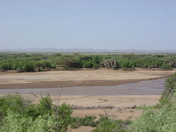
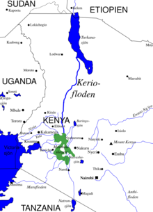
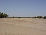
Kerio Valley lies between the Tugen Hills and the Elgeyo Escarpment in Kenya. It sits at an elevation of 1,000 meters in the Great Rift Valley.
Lokori is a Turkana settlement in Kenya's North Eastern Province, adjacent to the Kerio River. The settlement's inhabitants are traditionally pastoralists. Lokori is home to a number of prehistoric Namoratunga rock art and burial sites.

The Great Rift Valley is part of an intra-continental ridge system that runs through Kenya from north to south. It is part of the Gregory Rift, the eastern branch of the East African Rift, which starts in Tanzania to the south and continues northward into Ethiopia. It was formed on the "Kenyan Dome" a geographical upwelling created by the interactions of three major tectonics: the Arabian, Nubian, and Somalian plates. In the past, it was seen as part of a "Great Rift Valley" that ran from Madagascar to Syria. Most of the valley falls within the former Rift Valley Province.

The Kerio Valley National Reserve is a protected area in the Kerio Valley, Kenya, a branch of the Great Rift Valley. The 66 square kilometres (25 sq mi) reserve was created in 1983 and is managed by the Kenya Wildlife Service.

The greater Turkana Basin in East Africa determines a large endorheic basin, a drainage basin with no outflow centered around the north-southwards directed Gregory Rift system in Kenya and southern Ethiopia. The deepest point of the basin is the endorheic Lake Turkana, a brackish soda lake with a very high ecological productivity in the Gregory Rift.

Elgeyo-Marakwet County is one of Kenya's 47 counties. Elgeyo Marakwet County is located in the former Rift Valley Province. Its capital and largest town is Iten. It borders the counties of West Pokot to the north, Baringo County to the east, southeast and south, Uasin Gishu to the southwest and west, and Trans Nzoia to the northwest.
Loriu Plateau is an elevated Precambrian bedrock exposure at the southwest margin of Lake Turkana in Kenya. The plateau is only seasonally habitable due to aridity and was once home to fauna otherwise rare in Turkana. Loriu is west of and adjacent to the Barrier Volcano at the southernmost portion of Lake Turkana.

Kanapoi is a paleontological site in the Kenyan Rift Valley, to the southwest of Lake Turkana. Fossils were first found at Kanapoi in the 1960s by a Harvard expedition, and later by expeditions from the National Museums of Kenya.

Aiyangiyang is a basin in southern Turkana, Kenya, southeast of Lodwar. It is known by nomadic pastoralists for its seasonal water availability, and is an important archaeological and paleontological site with artifacts and remains from the African Middle and Late Stone Ages.
The Chok were a society that lived on the Elgeyo escarpment in Kenya.
Mutai is a term used by the Maa-speaking communities of Kenya to describe a period of wars, usually triggered by disease and/or drought and affecting widespread areas of the Rift Valley region of Kenya. According to Samburu and Maasai folklore, periods of Mutai occurred during the nineteenth century.
The Chemwal people were a Kalenjin-speaking society that inhabited regions of western and north-western Kenya as well as the regions around Mount Elgon at various times through to the late 19th century. The Nandi word Sekker was used by Pokot elders to describe one section of a community that occupied the Elgeyo escarpment and whose territory stretched across the Uasin Gishu plateau. This section of the community appears to have neighbored the Karamojong who referred to them as Siger, a name that derived from the Karimojong word esigirait. The most notable element of Sekker culture appears to have been a dangling adornment of a single cowrie shell attached to the forelock of Sekker women, at least as of the late 1700s and early 1800s.
The Siger people were a community commonly spoken of in the folklore of a number of Kenyan communities that inhabited regions of northwestern Kenya at various points in history.
Initially known as ceramic tradition "Gumban A," these clay vessels are now popularly known as Nderit Pottery.The burial sites containing fragments of Nderit Ware were initially unearthed by Louis Leakey in the 1930's.Nderit Pottery was first located in the Central Rift Valley of Kenya.Stylistic characteristics of Nderit Pottery discovered in the Central Rift Valley include an exterior decoration of basket-like and triangular markings into the clay’s surface.The vessels here also have intensely scored interiors that do not appear to follow a distinct pattern. Nderit Ware exemplifies the transition from Saharan wavy-line early Holocene pottery towards the basket-like designs of the middle Holocene. Lipid residue found on Nderit Pottery can be used to analyze the food products stored in them by early pastoralist societies.