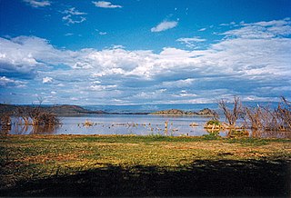
Lake Baringo is, after Lake Turkana, the most northern of the Kenyan Rift Valley lakes, with a surface area of 130 square kilometres (50 sq mi) and an elevation of 970 metres (3,180 ft). The lake is fed by several rivers: the Molo, Perkerra and Ol Arabel. It has no obvious outlet; the waters are assumed to seep through lake sediments into the faulted volcanic bedrock. It is one of the two freshwater lakes in the Rift Valley in Kenya, the other being Lake Naivasha.

The Burdekin River is a river located in North and Far North Queensland, Australia. The river rises on the northern slopes of Boulder Mountain at Valley of Lagoons, part of the western slope of the Seaview Range, and flows into the Coral Sea at Upstart Bay over 200 kilometres (124 mi) to the southeast of the source, with a catchment area of approximately 130,000 square kilometres (50,000 sq mi). The Burdekin River is Australia's largest river by (peak) discharge volume.

Macquarie River a watercourse that is part of the Macquarie–Barwon catchment within the Murray–Darling basin, is one of the main inland rivers in New South Wales, Australia.

Lake Bogoria is a saline, alkaline lake that lies in a volcanic region in a half-graben basin south of Lake Baringo, Kenya, a little north of the equator. Lake Bogoria, like Lake Nakuru, Lake Elmenteita, and Lake Magadi further south in the Rift Valley, and Lake Logipi to the north, is home at times to one of the world's largest populations of lesser flamingos. The lake is a Ramsar site and Lake Bogoria National Reserve has been a protected National Reserve since November 29, 1973. Lake Bogoria is shallow, and is about 34 km long by 3.5 km wide, with a drainage basin of 700 km2.
The Ilchamus, are a Maa-speaking people living south and southeast of Lake Baringo, Kenya. They number about 35,000 and are closely related to the Samburu living more to the north-east in the Rift Valley Province They are said to be the smallest ethnic group in Kenya. Their language is one of the Eastern Nilotic Maa languages, closely related to the Samburu language, to the point of it being considered a Samburu dialect by some. Together, Samburu and Ilchamus form the northern division of the Maa languages.

Jindabyne Dam is a major ungated rockfill embankment dam across the Snowy River in the Snowy Mountains of New South Wales, Australia. The dam's main purpose is for the generation of hydro-power and is one of the sixteen major dams that comprise the Snowy Mountains Scheme, a vast hydroelectricity and irrigation complex constructed in south-east Australia between 1949 and 1974 and now run by Snowy Hydro.

Environmental issues in Kenya include deforestation, soil erosion, desertification, water shortage and degraded water quality, flooding, poaching, and domestic and industrial pollution.

Baringo County is one of the 47 Counties of Kenya. It is located in the former Rift Valley Province. Its headquarters and largest town is Kabarnet. The county is home to Lake Baringo.

Lake Qaraoun is an artificial lake or reservoir located in the southern region of the Beqaa Valley, Lebanon. It was created near Qaraoun village in 1959 by building a 61-metre-high (200 ft) concrete-faced rockfill dam in the middle reaches of the Litani River. The reservoir has been used for hydropower generation, domestic water supply, and for irrigation of 27,500 hectares.

Ewaso Ng'iro is a river in Kenya which rises on the west side of Mount Kenya and flows north then east and finally south-east, passing through Somalia where it joins the Jubba River. The upper basin of the Ewaso Ng'iro River is 15,200-square-kilometre (5,900 sq mi). The river has a continuous water supply due to the glaciers on Mount Kenya. Ewaso Ng'iro feeds into Lake Ol Bolossat, the only lake in Nyandarua county and the larger Central Kenya. Ewaso Ng'iro crosses seven arid to semi-arid landscapes. It is characterized by vastly different physiographic features and species and has become a fundamental component to the survival of the wildlife, as well as the expansion of human population and socio-economic developments. Water, the limited land resource provided by the Ewaso Ng’iro watershed is unevenly distributed throughout the higher and lower regions of the catchment due to the large percentage necessary to maintain agricultural practices and climatic changes.
Nakuru County Council is a defunct local authority in Kenya. It was one of the largest county councils in the country. It is home to a population of around 1.6 million, living on some 5,000 square kilometres in the central part of the country. The Nakuru area has a rich history, with human settlements dating back more than 3,000 years. The population is very diverse, with residents that have migratory background from different parts of the country. According to 2002 government statistics, on a population total of 1,312,555, the youth population up to age 25 years was 56%. The percentage of pre-primary and primary school going age residents was 31%, and the County’s total labour force population was 54%. The population growth rate is 3.4%.

Marigat is a settlement in Baringo County, Kenya.
The Shule River flows generally westwards through the Tibetan Plateau and the desert regions of northwestern China. It starts in the Qilian Mountains and stretches for some 900 kilometres (560 mi); however, the river dries up about two-thirds of the way along its course and is lost in the Kumtag Desert, an endorheic basin, meaning its water never reaches the sea. Historically, the river reached farther west to Lop Nur, an intermittent salt lake in the Taklimakan Desert. Large irrigation diversions off the river and the gradual desertification of the region have reduced its flow significantly.

The Menindee Lakes is a chain of shallow ephemeral freshwater lakes connected to the Darling River to form a storage system. The lakes lie in the far west region of New South Wales, Australia, near the town of Menindee.
The Great Rift Valley is part of an intra-continental ridge system that runs through Kenya from north to south. It is part of the Gregory Rift, the eastern branch of the East African Rift, which starts in Tanzania to the south and continues northward into Ethiopia. It was formed on the "Kenyan Dome" a geographical upwelling created by the interactions of three major tectonics: the Arabian, Nubian, and Somalian plates. In the past, it was seen as part of a "Great Rift Valley" that ran from Madagascar to Syria. Most of the valley falls within the former Rift Valley Province.

The Waseges River is a river that rises on the slopes of the Nyandarua Plateau below the Aberdare Range in Kenya. The river flows north, then west and south to enter Lake Bogoria in the Great Rift Valley from the north after passing through a swamp. In 2002 rubies were found in the region of the Waseges River.
Kuresoi Constituency is one of the five constituencies that form Nakuru County, in the Rift valley province. Kenya. In the proposed Independent electoral and boundaries commission's report of 2012, Kuresoi district will be split into two constituencies; Kuresoi North and Kuresoi South. A large part of kuresoi is the East Mau forest, part of the largest water catchment in Kenya, Mau forest. Two major rivers, Mara River and Sondu Miriu have their sources in Kuresoi, Molo River which drains into Lake Baringo has one of its tributaries Ribeti starting in Kuresoi.
Ol Arabel is a river in the Great Rift Valley of Kenya that feeds Lake Baringo. It gives its name to a forest covering its headwaters and to a region.
Mochongoi is a community and a division in Baringo County, Kenya. Mochongoi is also an electoral constituency. The town lies in the northern end of the Aberdare Range and is a relatively new settlement in what was the Ol Arabel forest reserve.
Maji Mazuri is a settlement in Kenya's Baringo County along the Makutano-Ravine-Kampi Ya Moto highway. This is the most southerly tip of the greater Baringo area. It neighbors Kericho's Londiani and Nakuru's Kamara areas The settlement was formed by migrants who used to work in the Koibatek Forest but were either retrenched or retired at one time. As such Maji Mazuri is home to people from different ethnic groups of Kenya. The Agikuyu and Tugen people are however the majority population in the larger Maji Mazuri location of Eldama Ravine division.

