
A shield volcano is a type of volcano named for its low profile, resembling a shield lying on the ground. It is formed by the eruption of highly fluid lava, which travels farther and forms thinner flows than the more viscous lava erupted from a stratovolcano. Repeated eruptions result in the steady accumulation of broad sheets of lava, building up the shield volcano's distinctive form.

Newberry Volcano is a large, active, shield-shaped stratovolcano located about 20 miles (32 km) south of Bend, Oregon, United States, 35 miles (56 km) east of the major crest of the Cascade Range, within the Newberry National Volcanic Monument. Its highest point is Paulina Peak. Newberry is the largest volcano in the Cascade Volcanic Arc, with an area of 1,200 square miles (3,100 km2) when its lava flows are taken into account. From north to south, the volcano has a length of 75 miles (121 km), with a width of 27 miles (43 km) and a total volume of approximately 120 cubic miles (500 km3). It was named for the geologist and surgeon John Strong Newberry, who explored central Oregon for the Pacific Railroad Surveys in 1855.

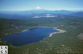
Mount Mazama is a complex volcano in the western U.S. state of Oregon, in a segment of the Cascade Volcanic Arc and Cascade Range. The volcano is in Klamath County, in the southern Cascades, 60 miles (97 km) north of the Oregon–California border. Its collapse, due to the eruption of magma emptying the underlying magma chamber, formed a caldera that holds Crater Lake. Mount Mazama originally had an elevation of 12,000 feet (3,700 m), but following its climactic eruption this was reduced to 8,157 feet (2,486 m). Crater Lake is 1,943 feet (592 m) deep, the deepest freshwater body in the U.S. and the second deepest in North America after Great Slave Lake in Canada.

Belknap Crater is a shield volcano in the Cascade Range in the U.S. state of Oregon. Located in Linn County, it is associated with lava fields and numerous subfeatures including the Little Belknap and South Belknap volcanic cones. It lies north of McKenzie Pass and forms part of the Mount Washington Wilderness. Belknap is not forested and most of its lava flows are not vegetated, though there is some wildlife in the area around the volcano, as well as a number of tree molds formed by its eruptive activity.
Medicine Lake Volcano is a large shield volcano in northeastern California about 30 mi (50 km) northeast of Mount Shasta. The volcano is located in a zone of east-west crustal extension east of the main axis of the Cascade Volcanic Arc and the Cascade Range. The 0.6 mi (1 km) thick shield is 22 mi (35 km) from east to west and 28 to 31 mi from north to south, and covers more than 770 sq mi (2,000 km2). The underlying rock has downwarped by 0.3 mi (0.5 km) under the center of the volcano. The volcano is primarily composed of basalt and basaltic andesite lava flows, and has a 4.3 by 7.5 mi caldera at the center.

The Anahim Volcanic Belt (AVB) is a west–east trending chain of volcanoes and related magmatic features in British Columbia, Canada. It extends from Athlone Island on the Central Coast, running eastward through the strongly uplifted and deeply dissected Coast Mountains to near the community of Nazko on the Interior Plateau. The AVB is delineated as three west-to-east segments that differ in age and structure. A wide variety of igneous rocks with differing compositions occur throughout these segments, comprising landforms such as volcanic cones, volcanic plugs, lava domes, shield volcanoes and intrusions.

Payún Matrú is a shield volcano in the Reserva Provincial La Payunia of the Malargüe Department, south of the Mendoza Province in Argentina. It lies in the back-arc region of the Andean Volcanic Belt, and was formed by the subduction of the Nazca Plate beneath the South American Plate. Payún Matrú, along with the Llancanelo, Nevado and Salado Basin volcanic fields, form the Payenia province. It has been proposed as a World Heritage Site since 2011.

The Suguta Valley, also known as the Suguta Mud Flats, is an arid part of the Great Rift Valley in Kenya (Africa), directly south of Lake Turkana.

Nemrut is a dormant volcano in Tatvan district, Bitlis province, Eastern Turkey, close to Lake Van. The volcano is named after King Nimrod who is said to have ruled this area in about 2100 BC.

Mount Tendürek is a shield volcano on the border of Ağrı and Van provinces in eastern Turkey, near the border with Iran. The volcano, which is mostly known for being near the supposed wreck site of Noah's Ark, is very large; its lava flows cover roughly 650 km2 (251 sq mi) across a swath of flat land. The mountain's two main features are the main summit crater Greater Tendürek, and a smaller crater known as Lesser Tendürek which lies to the east of the main crater. The slopes are very gentle and resemble a shield, after which the type is named. Mount Tendürek is known to have erupted viscous lava like that of volcanoes on the island of Hawaii.

Volcanic activity is a major part of the geology of Canada and is characterized by many types of volcanic landform, including lava flows, volcanic plateaus, lava domes, cinder cones, stratovolcanoes, shield volcanoes, submarine volcanoes, calderas, diatremes, and maars, along with less common volcanic forms such as tuyas and subglacial mounds.

The geology of the Pacific Northwest includes the composition, structure, physical properties and the processes that shape the Pacific Northwest region of North America. The region is part of the Ring of Fire: the subduction of the Pacific and Farallon Plates under the North American Plate is responsible for many of the area's scenic features as well as some of its hazards, such as volcanoes, earthquakes, and landslides.
The Barrier is an active shield volcano located in the north of Kenya. It is last known to have erupted in 1921.

The volcanic history of the Northern Cordilleran Volcanic Province presents a record of volcanic activity in northwestern British Columbia, central Yukon and the U.S. state of easternmost Alaska. The volcanic activity lies in the northern part of the Western Cordillera of the Pacific Northwest region of North America. Extensional cracking of the North American Plate in this part of North America has existed for millions of years. Continuation of this continental rifting has fed scores of volcanoes throughout the Northern Cordilleran Volcanic Province over at least the past 20 million years and occasionally continued into geologically recent times.
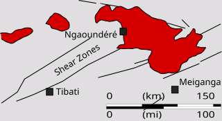
The Ngaoundéré Plateau is a highland area in the Adamawa Region of Cameroon. It contains Tchabal Nganha, a large volcano, and many other recent volcanic structures.

The Great Rift Valley is part of an intra-continental ridge system that runs through Kenya from north to south. It is part of the Gregory Rift, the eastern branch of the East African Rift, which starts in Tanzania to the south and continues northward into Ethiopia. It was formed on the "Kenyan Dome" a geographical upwelling created by the interactions of three major tectonics: the Arabian, Nubian, and Somalian plates. In the past, it was seen as part of a "Great Rift Valley" that ran from Madagascar to Syria. Most of the valley falls within the former Rift Valley Province.
Ol Doinyo Eburru is an active complex of volcanoes in the Great Rift Valley, Kenya to the northwest of Lake Naivasha. It is being exploited for geothermal energy. Soysambu Conservancy is located to the north of the massif, between Lake Elmenteita to the east and Lake Nakuru to the west.

Jom-Bolok, also known as Volcano Valley and East Sayan Volcanic Field, is a volcanic field in Russia, 200 kilometres (120 mi) west of Lake Baikal. It is part of the Baikal rift zone which is also responsible for volcanism elsewhere around Lake Baikal. The volcanic activity has generated long lava flows and cinder cones. One of the lava flows is 70 kilometres (43 mi) long and has a volume of 7.9 cubic kilometres (1.9 cu mi).
Lake Suguta is a former lake in Africa. It formed in the Suguta Valley, which is part of the East African Rift, south of Lake Turkana during the Holocene African humid period.

