
Maasai Mara, also sometimes spelled Masai Mara and locally known simply as The Mara, is a large national game reserve in Narok, Kenya, contiguous with the Serengeti National Park in Tanzania. It is named in honour of the Maasai people, the ancestral inhabitants of the area, who migrated to the area from the Nile Basin. Their description of the area when looked at from afar: "Mara" means "spotted" in the local Maasai language, because of the short bushy trees which dot the landscape.

Tanzania comprises many lakes, national parks, and Africa's highest point, Mount Kilimanjaro. Northeast Tanzania is mountainous, while the central area is part of a large plateau covered in grasslands. The country also contains the southern portion of Lake Victoria on its northern border with Uganda and Kenya.

Rift Valley Province of Kenya, bordering Uganda, was one of Kenya's eight provinces, before the 2013 Kenyan general election. Rift Valley Province was the largest and one of the most economically important provinces in Kenya. It was dominated by the Kenya Rift Valley which passes through it and gives the province its name. According to the 2009 Census, the former province covered an area of 182,505.1 square kilometres and would have had a population of 10,006,805, making it the largest and most populous province in the country. The bulk of the provincial population inhabited a strip between former Nairobi and Nyanza Province. The capital was the town of Nakuru.
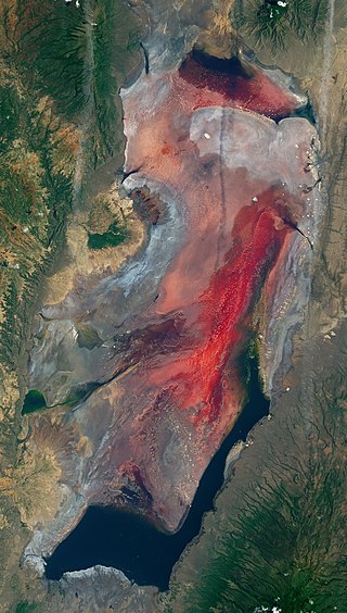
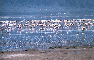
Lake Natron is a salt or alkaline lake located in north Ngorongoro District of Arusha Region in Tanzania at the border with Kenya. It is in the Gregory Rift, which is the eastern branch of the East African Rift. The lake is within the Lake Natron Basin, a Ramsar Site wetland of international significance. It is the only regular breeding area for Africa's lesser flamingoes, although this habitat is not protected and is under threat from planned development projects.
The Rift Valley lakes are a series of lakes in the East African Rift valley that runs through eastern Africa from Ethiopia in the north to Malawi in the south, and includes the African Great Lakes in the south. These include some of the world's oldest lakes, deepest lakes, largest lakes by area, and largest lakes by volume. Many are freshwater ecoregions of great biodiversity, while others are alkaline "soda lakes" supporting highly specialised organisms.

Ngorongoro Conservation Area is a protected area and a UNESCO World Heritage Site located in Ngorongoro District, 180 km (110 mi) west of Arusha City in Arusha Region, within the Crater Highlands geological area of northeastern Tanzania. The area is named after Ngorongoro Crater, a large volcanic caldera within the area. The Ngorongoro Conservation Area Authority administers the conservation area, an arm of the Tanzanian government, and its boundaries follow the boundary of the Ngorongoro District in Arusha Region. The western portion of the park abuts the Serengeti National Park, and the area comprising the two parks and Kenya's Maasai Mara game reserve is home to Great Migration, a massive annual migration of millions of wildebeest, zebras, gazelles, and other animals. The conservation area also contains Olduvai Gorge, one of the most important paleoanthropological sites in the world.

Lake Nakuru is one of the Rift Valley lakes, located at an elevation of 1,754 m (5,755 ft) above sea level. It lies to the south of Nakuru, in the rift valley of Kenya and is protected by Lake Nakuru National Park.

Arusha Region is one of Tanzania's 31 administrative regions and is located in the northeast of the country. The region's capital and largest city is the city of Arusha. The region is bordered by Kajiado County and Narok County in Kenya to the north, the Kilimanjaro Region to the east, the Manyara and Singida Regions to the south, and the Mara and Simiyu regions to the west. Arusha Region is home to Ngorongoro Conservation Area, a UNESCO World Heritage Site. The region is comparable in size to the combined land and water areas of the state of Maryland in the United States.

Nanyuki is a market town in Laikipia County of Kenya lying northwest of Mount Kenya along the A2 road and at the terminus of the branch railway from Nairobi. The name is derived from Enyaanyukie Maasai word for resemblance.
Hell's Gate National Park lies south of Lake Naivasha in Kenya, north west of Nairobi. Hell's Gate National Park is named after a narrow break in the cliffs, once a tributary of a prehistoric lake that fed early humans in the Rift Valley. It was established in 1984. A small national park, it is known for its wide variety of wildlife and for its scenery. This includes the Fischer's Tower and Central Tower columns and Hell's Gate Gorge. The national park is also home to five geothermal power stations at Olkaria. The park is equipped with three basic campsites and includes a Maasai Cultural Center, providing education about the Maasai tribe's culture and traditions.
Kajiado is a town in Kajiado County, Kenya. The town is located 80 km (49.7 mi) south of Nairobi, along the Nairobi – Arusha highway. Kajiado has an urban population of 24,678. Local people are predominantly of the Maasai tribe.

Lake Elmenteita is a soda lake, in the Great Rift Valley, about 120 km northwest of Nairobi, Kenya.

Nguruman Escarpment is an escarpment in southern Kenya. The escarpment is around 50 kilometres long and elongated in the N-W direction. Its northern edge is approximately 120 km southwest of Nairobi, while the southern edge is near the Tanzanian border, at the northwestern corner of Lake Natron. The Southern Ewaso Ng'iro River flows southward along the foot of the escarpment, while Loita Hills are located west of the escarpment. The escarpment forms the western wall of the Great Rift Valley. Below it are the vast plains and the volcanic hills of the Great Rift Valley and in the distance are Lake Magadi and Lake Natron.

The Great Rift: Africa's Wild Heart is a British nature documentary series, which began airing on BBC Two on 24 January 2010. A BBC/Animal Planet co-production, the three-part series focuses on the landscape and wildlife of the Great Rift Valley in East Africa. At the end of each fifty-minute episode, a ten-minute featurette, Inside The Great Rift, takes a behind-the-scenes look at the challenges of filming the series.
Ongata Rongai is a town located in Kajiado North, Kajiado County, Kenya. The town is situated 17 km (10.6 mi) south of the Nairobi CBD, East of the Ngong hills, and within the greater Nairobi Metropolitan Region. It lies 1,731 meters (5,682 feet) above sea level. According to the 2019 Census, it is the most populous town in Kajiado County and eleventh largest urban centre by population in Kenya.

The Great Rift Valley is part of an intra-continental ridge system that runs through Kenya from north to south. It is part of the Gregory Rift, the eastern branch of the East African Rift, which starts in Tanzania to the south and continues northward into Ethiopia. It was formed on the "Kenyan Dome" a geographical upwelling created by the interactions of three major tectonics: the Arabian, Nubian, and Somalian plates. In the past, it was seen as part of a "Great Rift Valley" that ran from Madagascar to Syria. Most of the valley falls within the former Rift Valley Province.

The Southern Ewaso Ng'iro is a river in the Great Rift Valley in Kenya. It plays an important role in the ecology of Lake Natron, the main regular breeding site for near-threatened lesser flamingos. Changes to land use in the river's headwaters or in the marshes before the river enters the lake could have a serious impact on this species.
The Northern Acacia–Commiphora bushlands and thickets are a tropical grasslands, savannas and shrublands ecoregion in eastern Africa. The ecoregion is mostly located in Kenya, extending north into southeastern South Sudan, northeastern Uganda and southwestern Ethiopia and south into Tanzania along the Kenya-Tanzania border.
The Southern Eastern Rift is a freshwater ecoregion in Kenya and Tanzania.
To the east and north of the Maasai Mara National Reserve, some of the former Maasai cattle-grazing areas have been converted into wildlife conservancies for tourism.
