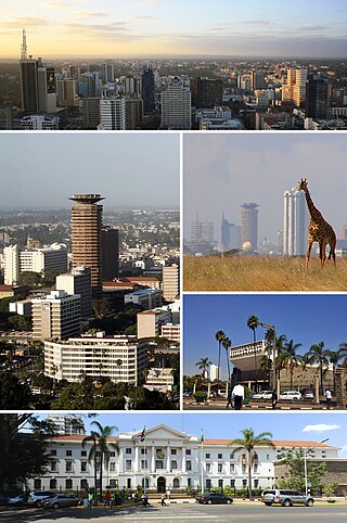
Nairobi is the capital and largest city of Kenya. The name is derived from the Maasai phrase Enkare Nairobi, which translates to 'place of cool waters', a reference to the Nairobi River which flows through the city. The city proper had a population of 4,397,073 in the 2019 census. The city is commonly referred to as 'The Green City in the Sun'.

Rift Valley Province of Kenya, bordering Uganda, was one of Kenya's eight provinces, before the 2013 Kenyan general election. Rift Valley Province was the largest and one of the most economically important provinces in Kenya. It was dominated by the Kenya Rift Valley which passes through it and gave the province its name. According to the 2009 Census, the former province covered an area of 182,505.1 square kilometres and would have had a population of 10,006,805, making it the largest and most populous province in the country. The bulk of the provincial population inhabited a strip between former Nairobi and Nyanza Province. The capital was the town of Nakuru.
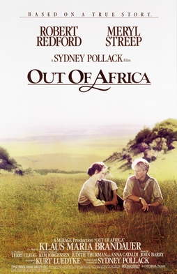
Out of Africa is a 1985 American epic romantic drama film directed and produced by Sydney Pollack, and starring Meryl Streep and Robert Redford. The film is based loosely on the 1937 autobiographical book Out of Africa written by Isak Dinesen, with additional material from Dinesen's 1960 book Shadows on the Grass and other sources.
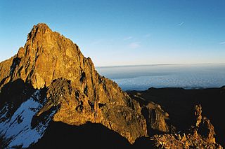
Mount Kenya is an extinct volcano in Kenya and the second-highest peak in Africa, after Kilimanjaro. The highest peaks of the mountain are Batian, Nelion and Point Lenana. Mount Kenya is located in the former Eastern and Central provinces of Kenya; its peak is now the intersection of Meru, Embu, Kirinyaga, Nyeri and Tharaka Nithi counties, about 16.5 kilometres south of the equator, around 150 km (90 mi) north-northeast of the capital Nairobi. Mount Kenya is the source of the name of the Republic of Kenya.

Lake Naivasha is a freshwater lake in Kenya, outside the town of Naivasha in Nakuru County, which lies north west of Nairobi. It is situated in the Great Rift Valley. The name derives from the local Maasai name ɛnaɨpɔ́sha , meaning "that which heaves," a common Maasai word for bodies of water large enough to have wave action when it is windy or stormy. Naivasha arose from a British attempt to pronounce the Maasai name. Literally, Lake Naivasha means "Lake Lake."

Nyeri is a town situated in the Central Highlands of Kenya. It is the county headquarters of Nyeri County and was the central administrative headquarters of the country's former Central Province. The town is situated about 150 km north of Kenya's capital Nairobi, in the country's densely populated and fertile Central Highlands. The town lies between the eastern base of the Aberdare (Nyandarua) Range, which forms part of the eastern end of the Great Rift Valley, and the western slopes of Mount Kenya.

Nakuru is a city in the Rift Valley region of Kenya. It is the capital of Nakuru County, and it is the fourth largest city in Kenya and the largest in the Great Rift Valley, Kenya|Rift Valley region. As of 2019, Nakuru had an urban population of 570,674, making it the largest urban center in the Rift Valley, above Eldoret, Uasin Gishu County. The city lies along the Nairobi–Nakuru Highway, 160 kilometres (99 mi) from Nairobi, the capital city of Kenya.

The Aberdare Range is a 160 km (99 mi) long mountain range of upland, north of Kenya's capital Nairobi with an average elevation of 3,500 metres (11,480 ft). It straddles the counties of Nyandarua, Nyeri, Muranga, Kiambu and Laikipia. The mountain range is located in west central Kenya, northeast of Naivasha and Gilgil and lies just south of the Equator. The mountain range is called Nyandarua among the Agikuyu people in whose territory this forest and mountain range is located. The name Nyandarua comes from the Kikuyu word rwandarua meaning a drying hide, due to the distinctive fold of its silhouette.

The Karen Blixen Museum, located 10 km outside of Nairobi, Kenya, "at the foot of the Ngong Hills", is the former African home of Danish author Karen Blixen, famous for her 1937 book Out of Africa which chronicles life at the estate.
Karen is a suburb of Nairobi in Kenya, lying south-west of Nairobi's central business district. The suburb of Karen borders the Ngong Forest and is home to the Ngong Racecourse. Karen and Langata previously formed a somewhat isolated area of mid to high-income residents, but the two suburbs have become increasingly interconnected and linked to the rest of Nairobi through the expansion of the eponymous Langata Road and Ngong Road, the latter project completed in 2021.

The Nairobi River is a river that flows across Nairobi, the capital city of Kenya. It is the main river of the Nairobi River Basin, with several parallel streams flowing eastward. All of the Nairobi basin rivers join east of Nairobi and meet the Athi River, which eventually flows into the Indian Ocean. The rivers are mostly narrow and highly polluted, though recent efforts to clean the rivers have improved water quality.

Ngong is a town near the Ngong Hills along the Great Rift Valley within Kajiado County, located in the southwest of Nairobi, in southern Kenya.

Mara Serena Airport is an airstrip in Maasai Mara, Kenya.
The Chyulu Hills is a mountain range in Makueni County in southeastern Kenya. It forms a 100-kilometre-long volcanic field in an elongated northeast–southwest direction. Its highest peak is 2,188 metres high.
Ndeiya is located in Kiambu County, Kenya, and is near the Great Rift Valley. The name is derived from a Maasai word.

Kiserian is a town in Kenya's Rift Valley Province, Kajiado County. Kiserian Town is bordered by Ongata Rongai, Ngong Town, Enoomatasiani Town and Kisamis Town. It is located on the boundary between Kajiado North and Kajiado West constituencies. It lies at the foot of the Ngong Hills, along Magadi Road just adjacent to the Kiserian dam. There is a famous Maasai community around Kiserian town and small Maasai villages called Olteyani and Olooseos. Among other social amenities, Kiserian has several primary schools and secondary schools, and a few higher education institutions. In the language of the Maasai, Kiserian means "a place of peace".
Ongata Rongai is a town located in Kajiado North, Kajiado County, Kenya. The town is situated 17 km (10.6 mi) south of the Nairobi CBD, East of the Ngong hills, and within the greater Nairobi Metropolitan Region. It lies 1,731 meters (5,682 feet) above sea level. According to the 2019 Census, it is the most populous town in Kajiado County and eleventh largest urban centre by population in Kenya.

The Great Rift Valley is part of an intra-continental ridge system that runs through Kenya from north to south. It is part of the Gregory Rift, the eastern branch of the East African Rift, which starts in Tanzania to the south and continues northward into Ethiopia. It was formed on the "Kenyan Dome", a geographical upwelling created by the interactions of three major tectonics: the Arabian, Nubian, and Somalian plates. In the past, it was seen as part of a "Great Rift Valley" that runs from Madagascar to Syria. Most of the valley falls within the former Rift Valley Province.
The Masai Agreement of 1904 was a treaty signed between the British East Africa Protectorate government and leaders of the Maasai tribe between 10 and 15 August 1904. It is often wrongly called the Anglo-Maasai Agreement, but that was not its proper name. The Maasai tribe agreed to cede possession of pastures in the Central Rift Valley Rift Valley in return for exclusive rights to two territories, a southern reserve in Kajiado and a northern reserve in Laikipia.
Ngong Hills Forest Reserve is the protected area of the larger Ngong Hills, Ngong, Kenya. The reserve is located on the southern tip of the Rift Valley region, 25 kilometres away from Kenya's capital, Nairobi. With the tallest peak standing at an altitude of 2,460 meters (8,070 ft) above sea level, it is the highest point in Ngong.


