
Olympus Mons is a shield volcano on Mars. It is over 21.9 km high as measured by the Mars Orbiter Laser Altimeter (MOLA), and is about two and a half times Mount Everest's height above sea level. It is Mars's tallest volcano, its tallest planetary mountain, and is approximately tied with Rheasilvia on Vesta as the tallest mountain currently discovered in the Solar System. It is associated with the volcanic region of Tharsis Montes. It last erupted 25 million years ago.

Mount Erebus is the second-highest volcano in Antarctica, the highest active volcano in Antarctica, and the southernmost active volcano on Earth. It is the sixth-highest highest point of an island, and the second most prominent mountain in Antarctica after Mount Vinson. It has a summit elevation of 3,794 metres (12,448 ft). It is located in the Ross Dependency on Ross Island, which is also home to three inactive volcanoes: Mount Terror, Mount Bird, and Mount Terra Nova. The mountain was named by Captain James Clark Ross in 1841 for his ship, the Erebus.

Haleakalā, or the East Maui Volcano, is a massive, active shield volcano that forms more than 75% of the Hawaiian Island of Maui. The western 25% of the island is formed by another volcano, Mauna Kahalawai, also referred to as the West Maui Mountains.

A shield volcano is a type of volcano named for its low profile, resembling a shield lying on the ground. It is formed by the eruption of highly fluid lava, which travels farther and forms thinner flows than the more viscous lava erupted from a stratovolcano. Repeated eruptions result in the steady accumulation of broad sheets of lava, building up the shield volcano's distinctive form.

Mount Washington is a deeply eroded volcano in the Cascade Range of Oregon. It lies within Deschutes and Linn counties and is surrounded by the Mount Washington Wilderness area.

Belknap Crater is a shield volcano in the Cascade Range in the U.S. state of Oregon. Located in Linn County, it is associated with lava fields and numerous subfeatures including the Little Belknap and South Belknap volcanic cones. It lies north of McKenzie Pass and forms part of the Mount Washington Wilderness. Belknap is not forested and most of its lava flows are not vegetated, though there is some wildlife in the area around the volcano, as well as a number of tree molds formed by its eruptive activity.

Capulin Volcano National Monument is a U.S. National Monument located in northeastern New Mexico that protects and interprets an extinct cinder cone volcano and is part of the Raton-Clayton volcanic field. A paved road spirals gradually around the volcano and visitors can drive up to a parking lot at the rim of the extinct volcano. Hiking trails circle the rim and lead down into the mouth of the volcano. The monument was designated on August 9, 1916, and is administered by the National Park Service. The volcano is located 5 kilometres (3.1 mi) north of the village of Capulin.

Mount McLoughlin is a dormant steep-sided stratovolcano, or composite volcano, in the Cascade Range of southern Oregon and within the United States Sky Lakes Wilderness. It is one of the volcanic peaks in the Cascade Volcanic Arc, within the High Cascades sector. A prominent landmark for the Rogue River Valley, the mountain is north of Mount Shasta, and south-southeast of Crater Lake. It was named around 1838 after John McLoughlin, a Chief Factor for the Hudson's Bay Company. Mount McLouglin's prominence has made it a landmark to Native American populations for thousands of years.

Ascraeus Mons is a large shield volcano located in the Tharsis region of the planet Mars. It is the northernmost and tallest of three shield volcanoes collectively known as the Tharsis Montes.

Mount St. Helens National Volcanic Monument is a U.S. National Monument that includes the area around Mount St. Helens in Cowlitz and Skamania Counties, Washington. It was established on August 27, 1982, by U.S. President Ronald Reagan, following the 1980 eruption. The 110,000 acre (445 km2) National Volcanic Monument was set aside for research, recreation, and education. Inside the monument, the environment is left to respond naturally to the disturbance. It was the third national monument to be managed by the U.S. Forest Service.
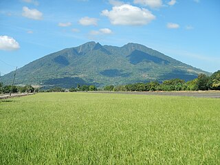
Mount Arayat is a potentially active stratovolcano sleeping in the province of Pampanga on the island of Luzon, Philippines, rising to a height of 1,033 metres (3,389 ft). The volcano has a breached crater on its northwest side with a smaller andesitic dome in the collapse amphitheater. There are historical records of eruption in Arayat and the only dated rocks are 530- and 650-thousand-year-old basalts predating the collapse and formation of the lava dome. However, weak steaming is currently present in some of the heavily eroded vents on the North Western side of the summit. Additionally an analysis report indicates that the volcano erupted over the last 2,000 years, but it is believed to refer to the volcanic activity of the volcano. The Mount Arayat National Park was established in 1933.

Mount Meru is a dormant stratovolcano located 70 kilometres (43 mi) west of Kilimanjaro in southeast Arusha Region, Tanzania. At a height of 4,562.13 metres (14,968 ft), it is visible from Mount Kilimanjaro on a clear day, and is the fifth-highest of the highest mountain peaks of Africa, dependent on definition.

Nakuru County is a county in Kenya. It is county number 32 out of the 47 Kenyan counties. Nakuru County is a host to Kenya's Fourth City – Nakuru City. On 1 December 2021, President Uhuru Kenyatta awarded a City Charter status to Nakuru, ranking it with Nairobi, Mombasa, and Kisumu as the cities in Kenya. With a population of 2,162,202, it is the third most populous county in Kenya after Nairobi County and Kiambu County, in that order. With an area of 7,496.5 km2, it is Kenya's 19th largest county in size. Until 21 August 2010, it formed part of Rift Valley Province.

Mount Longonot is a stratovolcano located southeast of Lake Naivasha in the Great Rift Valley of Kenya, Africa. It is thought to have last erupted in the 1860s. Its name is derived from the Maasai word Oloonong'ot, meaning "mountains of many spurs" or "steep ridges".
The Chyulu Hills is a mountain range in Makueni County in southeastern Kenya. It forms a 100-kilometre-long volcanic field in an elongated northeast–southwest direction. Its highest peak is 2,188 metres high.

The Great Rift: Africa's Wild Heart is a British nature documentary series, which began airing on BBC Two on 24 January 2010. A BBC/Animal Planet co-production, the three-part series focuses on the landscape and wildlife of the Great Rift Valley in East Africa. At the end of each fifty-minute episode, a ten-minute featurette, Inside The Great Rift, takes a behind-the-scenes look at the challenges of filming the series.

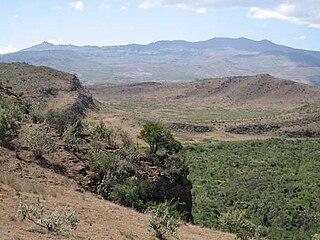
The Great Rift Valley is part of an intra-continental ridge system that runs through Kenya from north to south. It is part of the Gregory Rift, the eastern branch of the East African Rift, which starts in Tanzania to the south and continues northward into Ethiopia. It was formed on the "Kenyan Dome" a geographical upwelling created by the interactions of three major tectonics: the Arabian, Nubian, and Somalian plates. In the past, it was seen as part of a "Great Rift Valley" that ran from Madagascar to Syria. Most of the valley falls within the former Rift Valley Province.

The Gregory Rift is the eastern branch of the East African Rift fracture system. The rift is being caused by the separation of the Somali plate from the Nubian plate, driven by a thermal plume. Although the term is sometimes used in the narrow sense of the Kenyan Rift, the larger definition of the Gregory Rift is the set of faults and grabens extending southward from the Gulf of Aden through Ethiopia and Kenya into Northern Tanzania, passing over the local uplifts of the Ethiopian and Kenyan domes. Ancient fossils of early hominins, the ancestors of humans, have been found in the southern part of the Gregory Rift.
Ol Doinyo Eburru is an active complex of volcanoes in the Great Rift Valley, Kenya to the northwest of Lake Naivasha. It is being exploited for geothermal energy. Soysambu Conservancy is located to the north of the massif, between Lake Elmenteita to the east and Lake Nakuru to the west.
Menengai Forest is an urban forest situated within the town of Nakuru in Kenya. The Menengai Crater is within the forest. It was gazetted as a forest in the 1930s. It is surrounded by residential areas of Milimani Estate in the South, Ngachura and Bahati in the East, Solai in the North and Olo-Rongai in the West. Various Government of Kenya facilities have been hived off from the forest; these include the Kenya Broadcasting Corporation and the Nakuru G.K Prison. There is also a geothermal exploration project by the Geothermal Development Company inside the Menengai Crater floor.


