Narok County

Last updated

Narok County
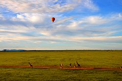
Hot Air Balloon Safari in Maasai Mara.jpg
Hot Air Balloon Safari in Maasai Mara
Flag of Narok County.gif
Narok County in Kenya.svg
Location in Kenya
Coordinates: 1°15′S35°37′E / 1.250°S 35.617°E / -1.250; 35.617
CountryFlag of Kenya.svg  Kenya
Formed4 March 2013
Capital Narok
Government
   Governor Patrick Keturet Ole Ntutu
Area
  Total17,921.2 km2 (6,919.4 sq mi)
Population
 (2019)
  Total1,157,873 [1]
Time zone UTC+3 (EAT)
Website narok.go.ke

Narok County [2] is a county in southwestern Kenya with an estimated population of 1,157,873 according to 2019 Census. The dominant ethnic group is the Maasai. Its capital and largest town is Narok, with the only other major urban centre being Kilgoris. [3] Narok County Government was formed by the County Governments Act of 2012 as prescribed in the 2010 Constitution of Kenya. Narok County governor is Patrick Ole Ntutu after winning in the 2022 elections and his Deputy is Tamalinye K. Koech.[ citation needed ]

Contents

Along with Kisii County, Narok County has been identified as having the highest level of practice of female genital mutilation in the country, despite the practice being outlawed in 2001. [4]

Religion

Religion in Narok County [5]

Religion (2019 Census)Number
Catholicism 152,607
Protestant 417,457
Evangelical Churches 350,885
African instituted Churches 57,673
Orthodox 6,277
Other Cristian 71,598
Islam 4,805
Hindu 249
Traditionists15,953
Other22,476
No ReligionAtheists 45,617
Don't Know3,710
Not Stated122

Geography

Narok County is situated in the southern part of the Great Rift Valley. It lies between latitudes 0° 50' and 1° 50' South and longitude 35° 28' and 36° 25' East. The county borders the Republic of Tanzania and six other counties – Nakuru, Bomet, Nyamira, Kisii, Migori County and Kajiado. [6]

The Maasai Mara National Reserve and Mau Forest are located in the county. [3]

Economy

The main economic activities in the county include pastoralism, crop farming, tourism and trade among other activities undertaken in small scale.

As of 2018, gold production from mines located in Narok County was at 111 kg (245 lb). [7]

County subdivisions

The county has six constituencies:

Local authorities (councils)
AuthorityTypePopulation*Urban pop.*
Narok Town41,09224,091
Narok CountyCounty324,6582,839
Total365,75026,930
* 1999 census. Source:
Administrative divisions
DivisionPopulation*Urban
population*
population
density
Area (km2)Headquarters
Central41,16222,48844935,5Narok
Loita15,557091728,6
Mara41,964094662,7
Mau77,6861,898302589,5
Mulot68,432095720,3
Olokurto44,326837361231,3
Ololulunga53,8280361495,2Ololulunga
Osupuko22,7950121899,6
Total365,75025,23324 (average)15,263
* 1999 census. Sources: , ,

Narok County wards

There are thirty Members of County Assembly (MCAs) representing the thirty wards at Narok County Assembly. These wards were formed in 2010 by the Boundaries Review Commission. There are six wards in Narok North Constituency, Narok South Constituency and Kilgoris Constituency respectively.

Narok West Constituency, Emurua Dikirr Constituency and Narok East Constituency each have four county wards [8]

Communities

Population

A boy running in the fields of Narok Little running boy in the Narok's fields (Kenya).jpg
A boy running in the fields of Narok
Historical population
YearPop.±%
1979 210,306    
1989 398,272+89.4%
1999 536,341+34.7%
2009 850,920+58.7%
2019 1,157,873+36.1%
source: [9]

Notable people

Related Research Articles

<span class="mw-page-title-main">Maasai Mara</span> National Reserve in Narok County, Kenya

Maasai Mara, also sometimes spelled Masai Mara and locally known simply as The Mara, is a large national game reserve in Narok, Kenya, contiguous with the Serengeti National Park in Tanzania. It is named in honour of the Maasai people, the ancestral inhabitants of the area, who migrated to the area from the Nile Basin. Their description of the area when looked at from afar: "Mara" means "spotted" in the local Maasai language, because of the short bushy trees which dot the landscape.

<span class="mw-page-title-main">Maasai people</span> Ethnic group located in Kenya and Tanzania

The Maasai are a Nilotic ethnic group inhabiting northern, central and southern Kenya and northern Tanzania, near the African Great Lakes region. The Maasai speak the Maa language, a member of the Nilotic language family that is related to the Dinka, Kalenjin and Nuer languages. Except for some elders living in rural areas, most Maasai people speak the official languages of Kenya and Tanzania, being Swahili and English.

<span class="mw-page-title-main">Uasin Gishu County</span> County in Kenya

Uasin Gishu County is one of the 47 counties of Kenya located in the former Rift Valley Province. Eldoret has the county's largest population centre as well as its administrative and commercial centre. "It lies between longitudes 34 degrees 50' east and 35 degrees 37' West and latitudes 0 degrees 03' South and 0 degrees 55' North. It is a highland plateau with altitudes falling gently from 2,700 meters above sea level to about 1,500 meters above sea level. The topography is higher to the east and declines gently towards the western border".

<span class="mw-page-title-main">Kisii, Kenya</span> Municipality in Kisii County, Kenya

Kisii is a municipality and urban centre in south-western Kenya and the capital of Kisii County. Kisii Town also serves as a major urban and commercial centre in the Gusii Highlands—Kisii and Nyamira counties—and the South Nyanza region and is the second largest town in formerly greater Nyanza after Kisumu City. Kisii municipality sits right at the centre of the western Kenya tourist circuit that includes the Tabaka Soapstone Carvings, Maasai Mara, Ruma National Park and part of the Lake Victoria Basin.

<span class="mw-page-title-main">Kericho County</span> County in Kenya

Kericho County is one of the 47 counties in Kenya. The county seats between longitude 35°02' and 35°40' East and between the equator and latitude 0°23' South with an altitude of about 2002m above sea level. It borders Uasin Gishu County to the North West, Baringo County to the North-East, Nandi County to the North-West, Nakuru County to the East and Bomet County to the South, Kisumu County to the Northwest and Nyamira County to the West. It has a population of 901,777 and an area of 2,111 km². Its capital and largest town is Kericho.

<span class="mw-page-title-main">Kapenguria</span> Town in Kenya

Kapenguria is a town in Kenya. It is the capital and largest urban center of West Pokot County. The town lies north east of Kitale on the A1 road along Kitale-Lodwar road in north Western Kenya. Kapenguria forms a municipality with a population of 40,751 as per the 2019 Kenya Population and Housing Census.

<span class="mw-page-title-main">Narok</span> Town in Narok County, Kenya

Narok is a town west of Nairobi that supports Kenya's economy in south-west of the country, along the Great Rift Valley. Narok is the district capital of the Narok County and stands as the major centre of commerce in the district. Narok has a population of around 120,000 people, mostly Maasai. The elevation of Narok is 1827 metres in altitude.

Njoro is an agricultural town 18 km west south west of Nakuru, Kenya situated on the western rim of the Rift Valley. Njoro town was the headquarters of the former Njoro District, hived off Nakuru District. It was declared as one of the constituencies of Nakuru County in 2010. It has a population of 238,773 people according to the 2019 census report that was published by the Kenya National Bureau of Statistics (KNBS).

Emarti is a town in Narok County, Kenya. The town is located in Kirindoni division, near Kilgoris. Emarti has a population of 18.300.

Kilgoris is a town in Narok County, Kenya. The town has a population of 70,475. Kilgoris is one of two major urban centres in Narok County, the other being Narok Town.

<span class="mw-page-title-main">Bomet</span> Municipality in Bomet County, Kenya

Bomet is the capital and largest town of Bomet County, Kenya. Bomet town has a total population of 110,963. It is located along the B3 Mai Mahiu-Narok-Kisii road. Bomet city is one of the eight sister cities to Milwaukee.

<span class="mw-page-title-main">Local authorities of Kenya</span> Bodies controlling local governance in urban areas in Kenya

Local authorities in Kenya are the bodies controlling local governance in urban areas in Kenya.

Trans Mara District was an administrative district in the former Rift Valley Province of Kenya. Its capital town was Kilgoris. The district had a population of 170,591 and an area of 2,846 km². It was created in 1994, when Trans Mara District was split from Narok District.

<span class="mw-page-title-main">David Rudisha</span> Kenyan middle-distance runner (born 1988)

David Lekuta Rudisha, MBS is a Kenyan middle-distance runner who specialized in the 800 metres. He is a two-time back-to-back Olympic champion from the 2012 London and 2016 Rio Olympics, a two-time World champion from the 2011 and 2015 World Championships in Athletics, and a world record holder at the event with a time of 1:40.91, set at the 2012 London Games on 9 August 2012. Rudisha is the first and only person to ever run 800 metres under 1:41, and he holds the three fastest, six of the eight fastest, and half of the twenty fastest times ever run in this event.

Kilgoris Constituency is an electoral constituency in Narok County, Kenya. It is one of six constituencies in the county. It used to be the only constituency in the former Trans Mara District. The constituency was established for the 1997 elections. The constituency has 18 wards, all electing councillors for the Trans Mara County Council.

<span class="mw-page-title-main">Kisii County</span> County in Kenya

Kisii County is a county in the former Nyanza Province in southwestern Kenya. Its capital and largest town is Kisii. The county has a population of 1,266,860 people. It borders Nyamira County to the North East, Narok County to the South, and Homa bay and Migori Counties to the West. The county covers an area of 1,318 km².

Sotik Constituency is an electoral constituency in Kenya established for the 1997 elections. It is one of five constituencies in Bomet County. Sotik has one major river, River Kipsonoi. Sotik is also a hilly place with the main crops being grown are tea and maize. The Nairobi Kisii highway passes through Sotik. Recently, many developments have occurred; Sotik Market was put up by the former governor Hon Isaac Ruto, since then infrastructure has been improving. Sotik is also a religious center with over 10 churches set up in the area, e.g., Bethel AGC, St Joseph's Sotik catholic church and Gustavo D' Kerich chapel.

<span class="mw-page-title-main">Sub-Counties of Kenya</span>

Sub-counties, also known as Districts, are the decentralised units through which government of Kenya provides functions and services. At national level, sub-counties take a more administrative function like security, statistical purposes, provision of government services, etc. Even though the sub-counties are divisions of counties, powers to create new national sub-counties lies with the national government. As of 2023, there are 314 sub-counties, compared to 290 constituencies. A deputy county commissioner is appointed by the state to lead each sub-county. The sub-counties are further divided into divisions, locations and sub-locations.

Narok District was an administrative district in Kenya. The Narok District is located in the Rift Valley Province, and has a population of 365,750. Its capital town is Narok.

Emurua Dikirr is an electoral constituency in Kenya. It is one of six constituencies of Narok County. The constituency was established for the 2013 elections. Since the 2013 Kenyan General Elections, Johana Kipyegon Ngeno represented the constituency in the Kenyan National Assembly. Ngeno was re-elected in 2017 as a coalition member of The Eagle Coalition and is the current Member of Parliament. the constituency has 95% christians and 2% muslims(most of them living in Chebaibai near Murkan).It is located in Narok county and famously known as Transmara East. Johana was reelected in 2022 as the MP.Its backbone is the growing of swee tpotoes. The area is predominantly inhabited by Kipsigis community which with few others mainly in businesses and working there.There has been high tension in terms of politics since but has never disrupted peace.

References

  1. "Kenya Census 2009 – Census – Kenya" . Retrieved 19 April 2018 via Scribd.
  2. "Welcome to Narok County Government | Kenya". narok.go.ke. Retrieved 28 May 2020.
  3. 1 2 "Narok County – County Integrated Development Plan 2018-2023". Maarifa Centre. Retrieved 17 October 2019.
  4. BBC News, "Kenyan Girls Flee Circumcision" (on circumcision), BBC News – In Pictures, 2003, webpage: BBC-News-In-Pictures-Kenya.
  5. "2019 Kenya Population and Housing Census Volume IV: Distribution of Population by Socio-Economic Characteristics" (PDF). Kenya National Bureau of Statistics. Retrieved 2 May 2021.
  6. "About Narok County". Narok County Government. Retrieved 30 July 2019.
  7. Michira, Moses. "Gold production in Narok doubles". The Standard. Retrieved 21 July 2020.
  8. "Narok County Wards and Constituencies". maasaimedia.com. Retrieved 3 May 2016.
  9. Kenya: Administrative Division population statistics