Kilifi County is a County Located in the Kenyan coast. It was formed in 2010 as a result of a merger of Kilifi District and Malindi District, Kenya. Its capital is Kilifi and its largest town is Malindi .[2] The county had a population of 1,453,787 people following the 2019 census and covers an area of 12,245.90km2 (4,728.17sqmi).[3][4]
The county is located north and northeast of Mombasa. Kilifi has fewer tourists than Mombasa County, however there is some tourism in Kikambala, Watamu, Malindi and Kilifi. The county is known for the Ruins of Gedi, which includes mosques[5] and tombs[6] dating from the 11th to the 17th century.
Kilifi was in 2025 listed by the New York Times among 'Top 52 Places to visit in 2025'.[2]
Economy
The county has a strong industrial sector with the Mabati Rolling Mill and the Athi River Cement Factory contributing heavily to the region's economy in employment provision and income generation.[13]
Kilifi County is also home to Africa's largest medical device manufacturer-Revital Healthcare (EPZ) Limited which was founded in 2008 to champion healthcare manufacturing and sustainability in Sub-Saharan Africa. ,
Agriculture
Opportunities exist in agriculture, particularly dairy and crop farming thanks to fertile soil and good weather. The county had a successful cashew nut milling industry.[14] Maize and cassava are the main subsistence crops and the main cash crops grown in the county include coconuts, cashew nuts, sisal, citrus fruits, mangoes and pineapples .
Demographics
Kilifi county has a total population of 1,453,787, of which 704,089 are males, 749,673 are females and 25 are intersex persons. There are 298,472 households, with 4.4 persons per household on average, and a population density of 116 people per square kilometre.[15][16] The major communities living in Kilifi County include Mijikenda,[17]Swahili,[citation needed]Bajuni,[18]Indians, Arabs and Europeans.
The county is covered by a network of 3,678.6km of roads. Of this, 2,230.9km is surfaced by earth, 1,091.5km is surfaced by murram and 356.2km is covered by bitumen.[30]
There are 7 post offices, with 6,800 installed letter boxes, 6,120 rented letter boxes and 680 vacant letter boxes.[32]
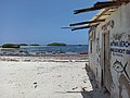
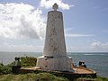
Image gallery
Watamu Beach
Sun rises over the Indian Ocean at Malindi
Vasco da Gama Pillar in Malindi
Mnarani ruins
Kilifi University
In popular culture
The final scenes of the 1992 feature film “Nel continente nero” (“On the Black Continent”) by director Marco Rizi take place in Kilifi County, among the ruins of Gedi.[33][34]
The novel “MALI D’AFRICA” (by Sara Cardelli) describes an impossible love in Malindi.[35]
Most of the events in the novel “Невозвращенец” (“The Non-Returnee”) by Andrei Gusev take place in Kilifi County and in Kilifi itself. The novel describes several years of life in Kilifi County, in the suburbs of Malindi in the early 2020s of the Russian writer Andy and his wife Jennifer, who was born in Kenya.[36][37]
This page is based on this Wikipedia article Text is available under the CC BY-SA 4.0 license; additional terms may apply. Images, videos and audio are available under their respective licenses.