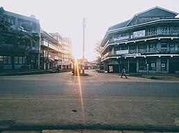
Bungoma

Last updated

Bungoma
Town
Church street.jpg
Khetias Euro.jpg
Khetias Crossroads.jpg
Bungoma bus park.jpg
Clockwise from top: Church street, Khetias Crossroads, Bungoma bus park, Kenyatta Avenue.
Kenya adm location map.svg
Red pog.svg
Location in Kenya
Coordinates: 00°34′00″N34°34′00″E / 0.56667°N 34.56667°E / 0.56667; 34.56667
CountryFlag of Kenya.svg  Kenya
County Bungoma County
Elevation
4,544 ft (1,385 m)
Population
 (2019 Census) [1]
  Total68,031
Time zone UTC+3 (EAT)
Area code 039
Climate Am
Bungoma

Bungoma is the capital of Bungoma County in Kenya. It was established as a trading centre in the early 20th century. It is located in Kenya's fertile Western region and at the foot of Mount Elgon, Kenya's second-tallest mountain. The town and the surrounding areas boast one of Kenya's highest average rainfalls, making Bungoma one of the nation's most important food baskets.

Contents

Name

Bungoma was named from eng'oma, the Bukusu word for "drums". The town was originally a meeting place for Bukusu elders. The sound of drums would emanate from the area as the meeting venue, leading to its eventual naming as Bungoma. [2]

Another account says that long ago the area was occupied by the Bungomek, a clan of the Sabaot. The Bungomek were later driven out by the Bukusu, but the name Bungoma, in reference to their occupation, remained.

Economy

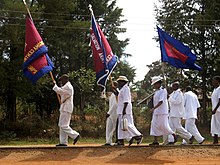
Farming is the main economic activity in the county. Bungoma County is dependent on sugarcane farming, with one of the country's largest sugar factories as well as numerous small-holder sugar mills. Maize is also grown for subsistence, alongside pearl millet and sorghum. Dairy farming is widely practised, as well as the raising of poultry. There is a small but important tourist circuit, centring on the biennial circumcision ceremonies that are mostly practiced by the Bukusu, Tachoni and Sabaot peoples.[ citation needed ] [3]

Aside from sugar processing, the town also contains various other manufacturing plants such as maize mills, large bakeries, dairy plants and a plastic factory. Other smaller-scale manufacturing activities include steel crafting, iron sheet production, garages and auto repairs.

The services sector is also quite vibrant. There is a busy retail sector dominated by local brands, several banks, insurance companies and large hotels to support the local tourist circuit.

Overview

Salvation Army in Bungoma Salvation Army, Bungoma.jpg
Salvation Army in Bungoma

The major economic activity in the area is sugarcane farming. This is because more than 67000 farmers directly depend on Nzoia Sugar Company Ltd. [4] Early businesses were supported by the Kenya-Uganda Railway which passes through the town. The collapse of Webuye paper mills and the struggling of nzoia sugar company has led to an economic nightmare in the county. Malakisi Ginnery that solely depended on cotton farming in Bungoma County and neighboring counties like Busia has struggled ages to start on its feet because of inadequate cotton supplies and few people have embraced cotton farming. Within Malikisi town, British America Tobacco (BAT) also had a well-established leaf buying also contributed and supported the inhabitants of part of Bungoma County that initially had embraced Tobacco farming. Most of the people previously employed there have looked for other jobs while some have totally relocated to other counties.

Major tertiary educational institutions include the Sang'alo Institute of Science and Technology, Mabanga Farmer's training center, SACRED Training Institute, Kibabii University and The Friends School kamusinga.

The Governor of Bungoma, Kenneth Lusaka, was elected in the 2022 election; he succeeded Wycliffe Wangamati, elected in 2017. Previously the mayor of Bungoma town was Barasa Mbinga of Ford-Kenya, who beat the previous mayor Majimbo Okumu of ODM in the 2009 mayoral election, voted by the Bungoma councilors. [5] The senator of Bungoma is Hon. Moses M. Wetangula.

See also

The current Bungoma governor is Kenneth Makelo Lusaka after edging out Wycliffe Wangamati in the August 2022 election.

Related Research Articles

<span class="mw-page-title-main">Trans-Nzoia County</span> County of Kenya

Trans-Nzoia County is a county in the former Rift Valley Province, Kenya, located between the Nzoia River and Mount Elgon, 380 km northwest of Nairobi. At its centre is the town of Kitale which is the capital and largest town. The county borders Bungoma to the west, Uasin Gishu and Kakamega to the south, Elgeyo-Marakwet to the east, West Pokot to the north and the republic of Uganda to the Northwest. Trans Nzoia covers an area of 2495.5 square kilometres.

<span class="mw-page-title-main">Luhya people</span> Number of ethnic groups in Kenya

The Luhya are a Bantu people and the second largest ethnic group in Kenya. The Luhya belong to the larger linguistic stock known as the Bantu. The Luhya are located in western Kenya and Uganda. They are divided into 20 culturally and linguistically united clans. Once known as the Kavirondo, multiple small tribes in North Nyanza came together under the new name Baluhya between 1950 and 1960. The Bukusu are the largest Luhya subtribe and account for almost 50% of the entire Luhya population, dominating other Luhya subtribes. They live in both Bungoma and Trans-Nzoia counties.

<span class="mw-page-title-main">Bukusu</span> Tribe living in Kenya

The Bukusu people are one of the 17 Kenyan tribes of the Luhya Bantu people of East Africa residing mainly in the counties of Bungoma and Trans Nzoia. They are the largest tribe of the Luhya nation, with 1,188,963 identifying as Bukusu in the 2019 Kenyan census. They speak the Bukusu dialect.

<span class="mw-page-title-main">Western Province (Kenya)</span> Province of Kenya

Western Province was one of Kenya's seven administrative provinces outside Nairobi. It is inhabited mainly by the Luhya people. Quakerism is widely practised here. Kenya's second highest mountain, Mount Elgon is located in Bungoma District. The Kakamega Forest rainforest is part of the area. The province capital was Kakamega. After the 2013 general election, and the coming into effect of the new constitution, provinces became defunct and the country is currently divided into 47 counties. Each county has its own government and therefore there is no central regional capital. Western Province became the Western region, comprising four counties: Kakamega, Bungoma, Vihiga, and Busia.

Kimilili is a town and area in Kenya's Bungoma County. The area is occupied mainly by the Bukusu and few Teso communities.It is a trading center for agricultural goods and services. The town has a population of 56,050

<span class="mw-page-title-main">Webuye</span> Place in Kenya

Webuye, previously named Broderick Falls, is an industrial town in western region of Kenya and home to the Tachoni people. It is located within Webuye West sub county in Bungoma County, at the slopes of chetambe hill Kenya. Located on the main road to Uganda, the town is home to the Pan African Paper Mills, the largest paper factory in the region, as well as a number of heavy-chemical and sugar manufacturers. The area is heavily populated and is used mainly for subsistence agriculture. The town has an urban population of 42,642.

<span class="mw-page-title-main">Bungoma County</span> County in Kenya

Bungoma County is a county in the former Western Province of Kenya with its capital in Bungoma town. It has a population of 1,670,570 of which 812,146 are males and 858,389 are females as per the 2019 census and an area of 2,069 km2. It has nine constituencies, namely: Bumula, Kabuchai, Kanduyi, Kimilili, Mt. Elgon, Sirisia, Tongaren, Webuye East and Webuye West.

<span class="mw-page-title-main">Kakamega County</span> County in Kenya

Kakamega County is a county in the former Western Province of Kenya. It borders Vihiga County to the South, Siaya County to the West, Bungoma and Trans Nzoia counties to the North and Nandi and Uasin Gishu counties to the East. Its capital and largest town is Kakamega. The county has a population of 1,867,579 and an area of 3,033.8 km2.

Matungu is a small town in the Western Province of Kenya. It is located in the Kakamega County.

Butere is a town in Kakamega County of the former Western Province of Kenya. It has an urban population of 4,725. Until 2010, the town was the capital of the former Butere/Mumias District.

Mount Elgon District was an administrative district in the Western Province of Kenya. Its capital town was Kapsokwony. In 2010, it was merged into Bungoma County.

<span class="mw-page-title-main">Homa Bay County</span> County in Kenya

Homa Bay County is a county in the former Nyanza Province of Kenya. Its capital and largest town is Homa Bay. The county has a population of 1,131,950 and an area of 3,154.7 km2. Lake Victoria is a major source of livelihood for Homa Bay County. It has 40 wards, each represented by an MCA in the Homa Bay county assembly located in Homa Bay town, which is the county headquarters.

Uganda's favorable soil conditions and climate have contributed to the country's agricultural success. Most areas of Uganda have usually received plenty of rain. In some years, small areas of the southeast and southwest have averaged more than 150 millimeters per month. In the north, there is often a short dry season in December and January. Temperatures vary only a few degrees above or below 20 °C but are moderated by differences in altitude.

<span class="mw-page-title-main">Maragoli</span> Kenyan people

The Maragoli, or Logoli (Ava-Logooli), are now the second-largest ethnic group of the 6 million-strong Luhya nation in Kenya, numbering around 2.1 million, or 15% of the Luhya people according to the last Kenyan census. Their language is called Logoli, Lulogooli, Ululogooli, or Maragoli. The name Maragoli probably emerged later on after interaction of the people with missionaries of the Quaker Church.

Chwele is a town in Bungoma County, Kenya. The town is an agricultural marketing centre located between Kimilili and Bungoma. The market is the major meeting point for farmers from the surrounding areas of Mount Elgon, Namwela, Sirisia, Lurende, Matibo and Chebukaka especially every Monday when there is a market day. Large quantities of maize, bananas, local vegetables, sim sim as well as livestock such as chicken, goats, cattle and sheep are available for sale. The market is Kenya's second largest open air market. The urban population was 9,797.

Uriri is an electoral constituency in Kenya. It is one of eight constituencies of Migori County. There are five wards in the constituency, all electing councillors to the Migori County council. The constituency was established for the 1997 elections. Its mainly inhabited by two ethnic tribes namely Luo and the Abaluhya, who live harmoniously, with kiswahili being the lingua franca in this sub county region.

<span class="mw-page-title-main">Tachoni</span> Ethnic group of western Kenya

The Tachoni is one of the tribes that occupy the western part of Kenya,its known for its gallant defense of the Chetambe in 1895 when resisting British rule. Tachoni people were masters at building forts such as Chetambe, Lumboka, and Kiliboti. It was their defiance of colonialism that led to the colonial government putting the entire region occupied by the Tachoni under administration of paramount chiefs drawn from Bunyala and Wanga communities. Sharing land with the Abanyala, the Kabras, Nandi, and Bukusu tribe. They live mainly in Webuye, Chetambe Hills, Ndivisi Matete sub-county-Lwandeti, Maturu, Mayoyo, Lukhokho, Kiliboti, Kivaywa, Chepsai, and Lugari sub-county in Kakamega County. Most Tachoni clans living in Bungoma speak the ' Olutachoni dialect which is a hybrid of the luhyia language of the luhyia people. Since they lost their original dialect during the divide and rule system used by the whites to scatter them for being resistants to their colonialism, they had to find a way to interact with their new neighbors and thats why they're subsequently mistaken as Bukusus. They spread from Kakamega county to Trans-Nzoia County, webuye especially around Kitale, Tambach in Iten Nandi in areas like kabiyet and kapsisiwa, kericho and to Uasin Gishu County near Turbo, Eldoret.

Among the Tachoni clans are Abachikha -further divided into Abakobolo, Abamuongo, Abachambai,Abamakhanga, Abacharia, and Abakabini, Abamarakalu, Abangachi -who are further divided into: Abawaila, Abakhumaya and Abawele, Abasang'alo, Abasamo, Abayumbu, Abaluu, Abarefu,Abanyangali, Abamuchembi, Abamakhuli, Abasioya, Abaabichu,Abacheo, Abamachina,Abaengele, Abamutama, Abakafusi, Abasonge, Abasaniaka, Abaabiya also known as Abakatumi, Abakubwayi,Abakamutebi, Abakamukong, Abamweya, Abalukulu,Abawande, Abatukiika, Abachimuluku. Note that the morpheme 'aba' means 'people'.

The Kabras, or Kabarasi, are a subtribe of the Luhya people of Kenya. They reside in Malava that is in the Kabras Division of Kakamega District, which is neighboured by the Isukha, Banyala, Tsotso, and the Tachoni. The exact origin of the Luhya people is currently disputed, but there are historians who believe that the group came from Bethlehem and migrated to their present-day location by way of the so-called Great Bantu Migration.

Milo is a sub-location in Sitikho Location of Bungoma County, Kenya. It is headed by Emmanuel Murokoyo. It is located approximately 34 degrees east of the Greenwich Meridian and 30 minutes north of the equator. It is bordered by the Nzoia and Muji rivers. The area is heavily populated, with agriculture being the main economic activity: Maize, millet, sorghum, beans, bananas and sugarcane are some of the crops produced in this area. The population also engages in fishing, livestock keeping and bodaboda operations.

Wycliffe Wafula Wangamati is a Kenyan national and politician who served as the second governor of Bungoma on a Ford Kenya ticket. Wangamati came to power after defeating Kenneth Lusaka in the 2017 election. In the election on August 9, 2022, he was again defeated by Kenneth Lusaka who was then the Speaker of the Senate. Wangamati only ruled Bungoma County for One term.

References

  1. "2009 Population and Housing Census: Spatial Distribution and Urbanisation Report". Kenya National Bureau of Statistics. Archived from the original on 14 November 2017. Retrieved 26 May 2018.
  2. Kiruga, Morris. (23 July 2013) "How local dialects influenced naming of west Kenya towns" Daily Nation
  3. Mabonga, Masolo (29 October 2020). "Bukusu circumcision practices, age groups and dumbfounding myths". Tuko.
  4. Nzoia Sugar Company [ better source needed ]
  5. The Standard, July 3, 2009: ODM loses Bungoma mayoral seat to Ford-Kenya

00°34′N34°34′E / 0.567°N 34.567°E / 0.567; 34.567