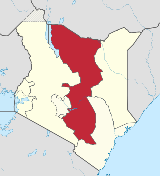
Embu, Kenya

Last updated

Embu
Kenya relief location map.jpg
Red pog.svg
Embu
Location in Kenya
Coordinates: 0°32′20″S37°27′30″E / 0.53889°S 37.45833°E / -0.53889; 37.45833
Country Kenya
Region Eastern
County Embu County
Government
  TypeMunicipal Board
  ChairpersonKen Mwige
Area
   Municipality 100 km2 (40 sq mi)
Elevation
1,350 m (4,429 ft)
Population
 (2019) [1]
  Density649.79/km2 (1,682.9/sq mi)
   Urban
64,979
Demonym Mwaembu
Time zone UTC+3 (EAT)
Postal Code
60100
Area code 068
Climate Aw
Website municipalityofembu.co.ke

Embu is a town located approximately 125 kilometres (78 mi) northeast of Nairobi towards Mount Kenya. Embu served as the provincial capital of the former Eastern Province and currently serves as the headquarters of Embu County in Kenya. Located on the south-eastern foothills of Mount Kenya, the Municipality of Embu had a population of 204,979 in 2019 census. [1] Embu is also the 8th Largest Municipality in Kenya. It is the commercial hub of the Central Eastern part of Kenya and provides an avenue for trade, tourism and highway transit between the national capital and the Northern Frontier.

Contents

History

Embu town is a major trading centre in Eastern Kenya. For a long time, it was the main economic centre for the Embu, Mbeere, Meru and Kamba communities as well as other communities from central Kenya. Mbeere was carved out of the former Embu district in the 1990s and Siakago town, about 25 km (16 mi) east of Embu town, was made its headquarters.

Origins of Embu people are cited from North West Africa. They moved south to Congo. Then they later moved Eastward to the coast of Kenya via Tanganyika. It is in Tanganyika that there were intermarriages with both natives and migrants from farther south (mostly Bantus). Due to many circumstances they moved North towards Meru leaving their relatives, the Gikuyu at Ithanga. They then crossed Igambang'ombe ford. They settled at Gikuuri near Maranga hills. They had come from Igembe and came to Tharaka where they also settled. They left Tharaka possibly due to famines and moved to the current Embu.

It is believed as they moved towards the slopes of Mt Kenya, they encountered pygmy tribes such as the Gumba and the Zimba in the forest; some of whom were cannibalistic. They are cultivators. They planted crops like sorghum, millet and sweet potatoes. Today they have cash crops like coffee, tea, miraa and macadamia, among others.

Geography

The Municipality of Embu has an elevation of 1,350 metres (4,429 ft), and is located on the foothills of Mount Kenya. It was the provincial headquarters of the defunct Eastern province, and is currently the Embu County Headquarters, hosting major public offices and institutions, including Embu Provincial General Hospital.

The area around the Municipality of Embu has conducive altitude for endurance training by athletes. As such, Kenyan athletes use the altitude and climate advantage of Embu for training, with specialised facilities at Kigari Teachers' Training College, about 15 km (9.3 mi) north of Embu Town.

Embu Town is known for its jacaranda trees that turn the municipality into a purple shower when in bloom. The jacaranda trees usually bloom from October to November each year, depending on rainfall. [2]

The nunicipality slopes from west to east, with the highest elevation at the Ruvingaci River, up to the Kangaru School as well as from Njukiri forest in the west to Muthatari in the east, a radius of about 10 km (6 mi) in size. Embu has a small airstrip (1 km (0.62 mi) long), which is 7.1 km (4.4 mi) southeast of the heart of the town.

Past Kigari Teachers College approximately 25 km from Embu Town is a small town known as Kianjokoma that is a center for other shopping centers like Miandari, Kathande, Kiriari, Irangi and others. This town is fast growing due to the situated Mungania Tea Factory and as well as a county hospital and a police line in the area. Other small towns in Embu are Kibugu, Karurumo, Rukuriri, Mukuuri, Kathageri, Kanja and Manyatta.

Climate

Climate data for Embu, Kenya
MonthJanFebMarAprMayJunJulAugSepOctNovDecYear
Mean daily maximum °C (°F)28.7
(83.7)
30.3
(86.5)
30.4
(86.7)
28.6
(83.5)
27.2
(81.0)
26.4
(79.5)
25.1
(77.2)
25.4
(77.7)
28.2
(82.8)
29.5
(85.1)
27.5
(81.5)
27.2
(81.0)
27.9
(82.2)
Mean daily minimum °C (°F)13.7
(56.7)
14.3
(57.7)
16.3
(61.3)
17.4
(63.3)
17.2
(63.0)
15.6
(60.1)
15.2
(59.4)
15.2
(59.4)
15.8
(60.4)
16.9
(62.4)
16.4
(61.5)
14.7
(58.5)
15.7
(60.3)
Average precipitation mm (inches)41
(1.6)
34
(1.3)
64
(2.5)
218
(8.6)
139
(5.5)
21
(0.8)
28
(1.1)
11
(0.4)
17
(0.7)
86
(3.4)
189
(7.4)
45
(1.8)
893
(35.2)
Average precipitation days43713103342815577
Source: World Meteorological Organization [3]

Religion

There are numerous Christian churches and ministries in Embu, including the Seventh Day Adventist, East African Pentecostal Churches Dallas, Gakwegori, Kigumo, Kanginga, Kathari, Karurumo, Kiritiri among others Anglican Church of Kenya's St. Paul's Cathedral, the Presbyterian Church of East Africa's Blue Valley, PCEA, the national independent church of Africa, the African independent Pentecostal church of Africa, Majimbo, Kangaru Kathangariri, Kibugu, Kavutiri, Ndunduri, Itabua, Gichera, Makengi, Kirigiri and the Roman Catholic Diocese of Embu's Sts. Peter and Paul Cathedral. The latter cathedral has a unique African-inspired design and is among the largest in Africa.[ citation needed ] Missions for Christ Ministries office and churches in Embu county. Churches under Missions for Christ Ministries includes Kevote Family Church, Embu town Family Church, Runyenjes Family Church, Kamugere Family Church and Kianjokoma Family Church. The national Independent church of Africa is located at Gakwegwori (Mwamba Imara), Kianjokoma, Kiriari, Kithunguriri, Kamugere, Mukuuri, Keria, Kibugu, and Kavutiri.

Another Protestant church, the first encountered, on entering Embu from Kirinyaga county is that of the Kenya Assemblies of God (KAG). It is better known as the Eastern Gate assembly as it is also the first church encountered on crossing into Eastern Province from all the Provinces except North Eastern.

Family Worship Church Inc is a Protestant Christian church founded in the early 1970s. It has the headquarters at Nembure and branches in Manyatta, Kithimu, Kiandundu, Gaikiro, Makengi and is in the process of starting a branch in Embu town.

Electoral subdivisions

Embu forms a municipality that has seven wards (Blue Valley, Itabua, Kamiu, Kangaru, Majengo, Matakari and Njukiri). All of them belong to Manyatta Constituency, which has a total of eleven wards. The remaining four are located within Embu County Council, the rural council of Embu. [4]

Notable residents

University education

See also

Related Research Articles

<span class="mw-page-title-main">Eastern Province (Kenya)</span> Province of Kenya

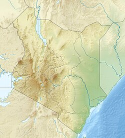
The Eastern Province of Kenya was one of 8 Provinces of Kenya. Its northern boundary ran along with that of Ethiopia; the North Eastern Province and Coast Province lay to the east and south; and the remainder of Kenya's provinces, including Central Province, ran along its western border. The provincial capital was Embu.

<span class="mw-page-title-main">Mukuuri</span>

Mûkûûrî is an administrative Location and township in Runyenjes Division, in Embu County, Kenya, with a population of about 25,000 people. It is named for a large, strong Sycamore Fig Tree that stood for over 100 years at the current site of the township. The Sycamore Fig tree symbolizes strength, rejuvenation and regeneration. Mûkûû-rî region lies on the green, rolling hills of the Mount Kenya slopes. The administrative region begins from the stone cliffs of Nthûngû waterfalls, all the way to Nthenge Njerû falls, through the famous Kirimiri Forest, stretching to the historic Gogo Salt lick, bordering Gitare. It is home to four public primary schools, including Kubu Kubu Memorial Boarding School and Muragari School, which is among the oldest schools in Embu and Kîrînyaga districts.
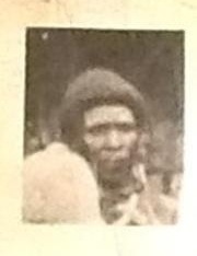
Kubu Kubu, born as Njagi wa Ikutha, was an Embu Mau Mau leader and general. His nom de guerre, Kubu Kubu, means "heavy thud" in Kîembu, referencing the thud his feet made due to his heavy build.
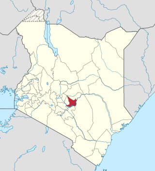
<span class="mw-page-title-main">Meru people</span> Kenyan ethnic group

The Meru or Amîîrú are a Bantu ethnic group that inhabit the Meru region of Kenya. The region is situated on the fertile lands of the north and eastern slopes of Mount Kenya in the former Eastern Province.

<span class="mw-page-title-main">Embu County</span> County in Kenya

Embu County is a county of Kenya. The capital of Embu County and the former Eastern province headquarters, Embu is a large and largely metropolitan area with a population of 608,599 persons. The county borders Kirinyaga to the west, Kitui to the east, Tharaka Nithi to the north and Machakos to the south. The county occupies an area of 2,821 km2.

<span class="mw-page-title-main">Local authorities of Kenya</span> Bodies controlling local governance in urban areas in Kenya

Local authorities in Kenya are the bodies controlling local governance in urban areas in Kenya.

<span class="mw-page-title-main">Mbeere District</span> Administrative district in Kenya

Mbeere District was a former administrative district in the Eastern Province of Kenya. Its capital town was Siakago. The district had a population of 170,950 and an area of 2,093 km2. The district was split from Embu District in 1996. In 2010, it was merged into Embu County.

<span class="mw-page-title-main">Embu people</span> Kenyan ethnic group

The Embu or Aembu are a Bantu people indigenous to Embu county. The region is situated on the southern slopes of the former Eastern province. They belong to the northeastern Bantu branch and speak the Embu language known as Kiembu as a mother tongue. It belongs to the Bantu branch of the Niger-Congo family. Kimeru, Kikuyu, and Kikamba share similar language characteristics. To the west, Embu neighbours are the closely related Kikuyu in Kirinyaga, Nyeri, Kiambu, Muranga and Nyandarua counties. The Meru people border the Embu to the East.

<span class="mw-page-title-main">Chuka, Kenya</span>

Chuka is a town on the eastern slopes of Mount Kenya, in Kenya about 65 km south Of Meru Town. It falls within Tharaka-Nithi County and the former Eastern Province. Between 1992 and 2009, Chuka was the capital of Tharaka Nithi District. Tharaka Nithi District was further split into Meru South and Tharaka Districts with Chuka remaining the Capital of Meru South. Later, Meru South and Tharaka were amalgamated into Tharaka-Nithi County.

Mbeere North Constituency is an electoral constituency in Embu County, Kenya. It was formerly known as Siakago Constituency, one of two constituencies of the former Mbeere District. It has five wards, all of which elected councillors for the Mbeere County Council.

Kangaru School is located in the Embu County, Kenya. It was built by the first missionaries that arrived in Kenya during the colonialism in the 1920s. It was rebuilt in 1947 by Sir Robin Wainright on a Harambee basis. There is a nearby village called Kangaru which is probably where the name comes from. There is a river close to the school, the Kapingazi River.

<span class="mw-page-title-main">Mbeere people</span> Ethnic group in Kenya

The Mbeere or Ambeere people are a Bantu ethnic group inhabiting the former Mbeere District in the now-defunct Eastern Province of Kenya. According to the 2019 Kenya National census, there are 195,250 Mbeere who inhabit an area of 2,093 km². They speak Kīmbeere language, a dialect of Embu, which is very similar to the languages spoken by their neighbours, the Kamba, Embu and Kikuyu.

<span class="mw-page-title-main">Runyenjes</span> Town in Embu County, Kenya

Runyenjes is the second largest town in Embu County, Kenya. It is located about 150 km from Nairobi, and 75 km from Mount Kenya, at an altitude of 1500m.The population is estimated at 58,000 people, the majority of which are the Embu People who speak Kiembu, a Bantu language, as well as Kiswahili and English, the two official languages in Kenya. The area offers scenic views, with densely wooded hills, gentle valleys, flowing streams and rivers, waterfalls, as well as small-scale farms.

Peter Njeru Ndwiga is a Kenyan politician. He is the former Senator for Embu County and the chairman of the Agriculture and Livestock Committee of the Senate. He was minister for the Co-operative Development and Marketing in Kenya and a former member of parliament for the Manyatta Constituency and Runyenjes Constituency. He was member of parliament for the Manyatta Constituency which is now in Embu County on Party of National Unity ticket between 2002 and 2007. Prior to this, he was the member of parliament for Runyenjes Constituency between 1992 and 1997 and then the member of parliament for the newly created Manyatta Constituency between 1998 and 2001.

<span class="mw-page-title-main">Sub-Counties of Kenya</span>

Sub-counties, also known as Districts, are the decentralised units through which government of Kenya provides functions and services. At national level, sub-counties take a more administrative function like security, statistical purposes, provision of government services, etc. Even though the sub-counties are divisions of counties, powers to create new national sub-counties lies with the national government. As of 2023, there are 314 sub-counties, compared to 290 constituencies. A deputy county commissioner is appointed by the state to lead each sub-county. The sub-counties are further divided into divisions, locations and sub-locations.

Embu District was an administrative district in the Eastern Province of Kenya. Its capital town is Embu. The district has a population of 278,196. The district was created by the colonial government as part of the divisions of the colony. Prior to independence, Kirinyaga District was carved out of Embu.

<span class="mw-page-title-main">Martin Wambora</span> Kenyan politician

Martin Nyaga Wambora is a Kenyan politician. He is the first governor of Embu County in Kenya after winning on a TNA ticket in the Embu gubernatorial elections which was conducted in March 2013. He would later become the first Governor in Kenya to be impeached, not once but twice but he successfully challenged the impeachment later and was overwhelmingly Re-elected in 2017 winning his 2nd term in office. He was a former member of parliament for Runyenjes Constituency from 2003 to 2007. Prior to becoming the governor of Embu County, he served as the chairman of the board of Kenya Airports Authority and led to its winning of the two most prestigious airport industry awards in 2011.

University of Embu is a Kenyan chartered university. It transitioned from a constituent college to a full university on 7 October 2016.

Stanley Nyagah (1936–2005), nicknamed Kĩthũng'a, was a Kenyan educationist, civil servant, technocrat and, entrepreneur who, between 1983 -1988, served as Member of Parliament for Embu North constituency, now split into Runyenjes constituency and Manyatta constituency. His campaign symbol was a key (rũvungoro). The key symbolized the opening up of hitherto inaccessible public resources to the masses. While in parliament, he served on the public investments committee.

<span class="mw-page-title-main">Gogo Salt Lick, Kenya</span> Natural salt lick in Embu county

Gogo Salt Lick is a naturally occurring salt lick located in Embu County, Kenya.

References

  1. 1 2 "2019 Kenya Population and Housing Census Volume II: Distribution of Population by Administrative Units (Table 2.5: Distribution of Population by Urban Centres, Sex* and County, p. 241)". Kenya National Bureau of Statistics. Retrieved 21 February 2020.
  2. WANZALA, JAMES. "Embu's wobbling growth". The Standard. Retrieved 19 January 2024.
  3. "World Weather Information Service – Embu". World Meteorological Organization. Retrieved 31 August 2016.
  4. Electoral Commission of Kenya: Registration centres by electoral area and constituency Archived June 28, 2007, at the Wayback Machine