Eldoret is town and urban centre in Kenya. Gazetted as a municipality, it is in the Rift Valley region, and it serves as the capital of Uasin Gishu County. The town was referred to by white settlers as Farm 64 and colloquially by locals as 'Sisibo'.[2] As per the 2019 population census,[3] Eldoret is the fifth most populated urban area in the country after Nairobi, Mombasa, Nakuru and Ruiru.[4] Lying south of the Cherangani Hills, the local elevation varies from about 2,100 metres (6,900ft) at the airport to more than 2,700 metres (8,900ft) in nearby areas. The population was 289,380 in the 2009 Census,[1][5] and it was the fastest growing city in Kenya with 475,716 people according to 2019 National Census. Eldoret was on course to be named Kenya's fourth city,[6] but was edged out by Nakuru in 2021.[7]
The name "Eldoret" is based on the Maasai word "eldore" meaning "stony river"; a reference to the bed of the Sosiani River (a tributary of the Nile), that runs through the town.[8]
History
Eldoret and the plateau around it had been occupied by the Sirikwa for several centuries prior to the era of Maasai ascendancy.[9] Innovation in weaponry was introduced by the Maasai era of the late 18th and 19th centuries. With new weapons and forms of governance, they swept down from their original homelands in the north, closer to Lake Turkana, down to their present homelands south of Kenya. The Maasai clan that took over the Plateau were known as the Ilwasin Kishu, after whom it is presently named.
In August 1908, fifty-eight families of displaced Afrikaners left Nakuru for the Uasin Gishu plateau after a journey from South Africa by sea and by rail from Mombasa. Led by Jan van Rensburg, they traveled using wagons that would often get stuck in mud, finally arriving at Sergoit Hill on 22 October of that year. Jan Ernest Kruger would later own the 2,000 hectares (5,000 acres) Sergoit farm, now owned by Sergoit Golf and Wildlife resort.
The land had earlier been surveyed by a certain van Breda and the new arrivals took up leaseholds of between 320 and 2,020 hectares (800 and 5,000 acres) on condition that they would develop it within five years. Each family built a shack, put up fences, in-spanned oxen to simple ploughs and turned the first furrows. They sowed wheat, maize and vegetables. These actions laid the foundation for the transformation of the Plateau into a prosperous agricultural region.
The farms were later officially registered and each was given a number.[10]
Eldoret was established in the midst of the farms they created on what was known to the settlers as "Farm 64", "64" or "Sisibo" to the locals because at that time it was 103 kilometres (64mi) from the newly built Uganda Railway railhead at Londiani.[11] Willy van Aardt owned the farm. The Central Lounge in Eldoret is all that remains of Willy's farm.
The official town site started in 1910 with the development of a Post Office at "Sisibo". This was followed shortly after by the arrival of 60 more Afrikaner families in 1911.[12] The governor decided to establish an administrative centre in the area in 1912 and thus the Post Office was renamed from "64" to a new official town name: "Eldoret". Becoming an administrative centre caused an enormous increase in trade within the prospective city. A bank and several shops were built.
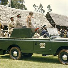
Kenya's first president, Jomo Kenyatta, opens the Eldoret Agricultural Show in 1968.
The Uganda Railway extension, from Londiani towards Uganda, reached Eldoret in 1924, starting a new era of prosperity and growth. In 1928, a piped water supply from the Sosiani River was installed and in 1933, an electricity generator plant was installed by the East African Power and Lighting Company. By that time, Eldoret had a small airport, and low-cost rental housing had been constructed.[12]
In the 1950s the town was literally divided into two, along the main street (now Uganda Road), with the Afrikaners on the north and the British on the south. The former took their children to Highland School, (now Moi Girls High School)[13] and the latter, to Hill School.[14] Recreation was also along the divide – 'Brits' used the Lincoln Hotel and the Race-Course near the now "Chinese Area" while the Afrikaners converged at the Wagon Wheel for recreation.
Daniel Arap Moi was born in the neighboring Baringo District, and under his presidency, the town was developed further. The country's second institution of higher learning, Moi University, was established by the government in 1984 and the third international airport was subsequently constructed, significantly boosting the fortunes of the town.
By 1987, only two Afrikaner households remained in Eldoret, with the rest having moved back to South Africa in the late 1950s and early 1960s, in the aftermath of the Mau Mau rebellion[15] and in anticipation of independence.
The town was significantly impacted by the 2007–2008 Kenyan crisis when violence gripped Kenya in the aftermath of controversial general elections. The athlete Lucas Sang was murdered about 10 kilometres (6.2mi) away from the town while on his way home to Chepkoilel. On 1 January 2008, a mob attacked and set fire to a church located near Burnt Forest, a satellite town of Eldoret. Hundreds of people had taken refuge during Kenyan massacres. As a result, about forty to eighty people,[16] mostly Kikuyu, were burnt to death.
Eldoret has a subtropical highland climate (Köppen climate classificationCfb). The town, lying over 2,000m (6,600ft) above sea level, has a moderate to cool climate. The temperature falls significantly at night, and in the cold season (May–August) it is regularly in the single digits Celsius.
Climate data for Eldoret (2120 m), Kenya (1941-1968, Records: 1930-1968)
Eldoret is governed by the County Government of Uasin Gishu which manages all the town's affairs. The city is divided into thirteen wards. Six of them (Huruma, Kamukunji, Kapyemit, Kidiwa/Kapsuswa, and Stadium/Industrial, Market) are in Eldoret North Constituency, Three (Hospital, Kapsoya and Kimumu/Sergoit) are in Eldoret East Constituency, and the remaining four (Kipkenyo, Langas, Pioneer/Elgon View and Race Course) are part of Eldoret South Constituency. All of these three constituencies have more wards within other local authorities than Eldoret municipality.[20]
Suburbs
Eldoret has a number of estates. Estates vary in that some are posh and others are resided in by the middle-class community. Almost every estate has its own identity. Some of the estates include Elgon View, Langas, Kapseret, Huruma, Kapsoya, Shauri, Kipkorgot, Kahoya, West Indies, West, Kipkaren, Kimumu, Jerusalem, Annex, Mwanzo,Hawaii, Action, Mailinne, Pioneer, Outspan, Kiplombe, Kamkunji, Samar, Silas, Kenya Service, Cheplaskei, Chinese, Road Block, Peris, Junction, Munyaka, Hillside, Eldoville, Juniorate among many others.
Economy
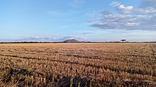
Large wheat plantation near Eldoret. Sergoit hill seen in the background
Eldoret is surrounded by prime agricultural lands and acts as a trading centre for Uasin Gishu's economy which is driven by large-scale grain farming, dairy and horticultural farming. The town is also a local manufacturing hub with a number of nationally recognised manufacturing concerns, including Raiplywoods, Rupa Textiles, Kenya Pipeline Company, Kenya Co-operative Creameries as well as corn, wheat and pyrethrum factories all within the town.[21]
The town is home to a large market and is known for the Doinyo Lessos cheese factory, Moi University and Eldoret International Airport. The runners from Eldoret have also contributed significantly to the economy of Eldoret town, primarily investing in small businesses and real estate, from their winnings in races all over the world. Moses Kiptanui is a stake holder in one of the largest buildings Komora that houses a large supermarket chain and many offices.
Notable professional firms include Nyairo and Company, the oldest law firm in the town`, founded by Alfred Momanyi Nyairo in the sixties. Other law firms include Wabomba Masinde and Associates advocates, Gumbo and Associate Advocates, Mburu Maina & Company Advocates, Nyaundi Tuiyott & Company Advocates, Kalya & Company Advocates, Chebii and Company Advocates and Gicheru & Company Advocates.
Industries
Textiles
The town has an industry that is led by Ken Knit (Kenya). It is the first, fully integrated textile manufacturing company in East and Central Africa and has been based in Eldoret for close to 50 years. It is Kenya's leading manufacturer of wool products and with a workforce of 2,000, is presently the largest textile related employer in the North-Rift.[22]
Another notable textile firm is Rivatex EA which was opened in 1975 by then Vice President, Daniel Toroitich arap Moi as Rift Valley Textiles (Rivatex), a parastatal that was the first Kenyan textile mill to operate computerized mills. It quickly became a success, achieving profitability within three years while employing 400 people and consuming 3,000 tons of cotton a year at its peak. By the late 1990s, the liberalization of Kenya's market which led to massive imports of cheap used clothing coupled with mismanagement led to the decline of the country's textile industry. Rivatex in Eldoret was placed under receivership in 1998 and finally shut its doors in 2000.[23]
The town of Eldoret, through Moi University and its subsidiary firm Rivatex, has played a leading role in the revival of the Kenyan textile industry.[23][24]
The defunct Rivatex was purchased from the Government of Kenya in 2007 by Moi University as a facility for research, product development, extension and production. The university identified the high cost of imported dyes as a factor affecting profitability. This was resolved in 2008, when Prof Richard Mibey, invented the Tami Dye, a natural dye made from Mexican Marigold which was previously considered a weed in the surrounding regions. The university holds the patent to this dye.[23]
Being able to produce affordable dye in Kenya has been a key contributing factor to the revival of Rivatex East Africa and the wider Kenyan textile industry.[24] The university won a $60 million grant from the World Bank to carry out a face-lift as a result of the work on the Tami Dye. It also secured a pledged investment of $40 million from the Indian Government.[23]
Digital assembly
In mid-2019, Rivatex reopened following major renovations and restructuring. As part of this effort, it opened a Digital Assembly Plant with the capacity to produce laptops, tablets, electric meters, smartphones and other digital devices.[25]
Military
The town is host to the Moi Barracks for the Kenya Defence Forces. The barracks has a memorial for Kenyan soldiers killed in battle in Somalia. The town is also home to the Kenya Ordnance Factories Corporation since 1997, a military installation that was the first manufacturer of small arms and ammunition in the region. Its customers include the Kenya Police, Wildlife Service, the Army, licensed dealers and carriers as well as friendly governments.
Fertilizer
The Toyota Tsusho Corporation built Kenya's first full scale fertilizer blending factory at Ngeria on the outskirts of Eldoret.[26] The $15 million plant has the capacity to produce 150,000 tonnes per year which is 25% of Kenya's 600,000 annual requirement.[27]
Services
ICT
In early 2019, Safaricom, Kenya's largest mobile network operator, set up its second largest call centre, and its first outside Nairobi,[28] in Eldoret town. The Kshs 900 million facility provides employment to 800 individuals of whom 300 are paid interns from local universities.[29]
The town is also home to the MGW site, located at Kapsoya, the first of Safaricom's data centre in the North Rift, set up in 2015.[30]
Tourism
Eldoret has traditionally not been known as a tourist destination and does not have much to differentiate it from Kenya's other highland centres. Being Kenya's fifth-largest town however, it is a great deal bigger and serves as a base for touring the North-Rift circuit. The town has a decent variety of accommodation options, notably the Sirikwa Hotel,[31] Poa Place,[32] The Noble Hotel and Conference Centre [33] and the ultra-modern Boma Inn[34] as well as enough night-life options to interest one for an evening or two.[35]
Surrounding region
Koitalel Arap Samoei Mausoleum and Museum in Nandi Hills; a historic monument located close to Eldoret
The town and its surrounding regions has also lately grown into a sports tourism destination thanks to a number of residents, renowned world runners and a high-altitude that makes the local area suitable for athletics training.[21]
Notable attractions within easy distance of Eldoret include the Nandi Hills area to the south, home of the Nandi, the fiercest early opponents to British rule. It is also the home of the Chemosit, a crypto-beast that is said to devour human brains.[35]
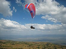
Paraglading in Elgeyo Marakwet
To the north lies the town of Iten, capital of Elgeyo Marakwet county and the world's foremost source of elite-middle and long distance runners. It is a popular destination for foreigners looking to hone their athletics talent[36] and time at its high altitude training centres form part of a number of elite athletes training regimens. Notably, altitude training here was a key element of Mo Farah's preparations before his 5000m and 10000m gold medals at London 2012 and World Championships 2013.[37]
Elgeyo Marakwet is also increasingly gaining a global reputation as a paragliding destination. It has become the place to go to fly 100–200km (62–124mi) out-and-returns in January with world records across both distances having been set in the Kerio Valley in 2013 and 2014 respectively.[38]
Points of interest
Champions Monument
Champions Monument located in Eldoret, Kenya
The Champions Monument is situated at the junction of Kaptagat and Nairobi roads and was erected in honour of retired, elite and upcoming athletes in the country. The bronze monument, erected by Mediheal Group of Hospitals, depicts two female athletes and two male athletes attached on a world map running towards different directions. One of the males is holding an Olympic torch in one hand while the rest have their hands raised up as a sign of victory. It also has an image of a male athlete mounted on the top draped in the Kenyan flag.[39]
Chepkiit Waterfalls
Located some 25 kilometres (16mi) away from Eldoret at a point where the River Sosiani plunges 100 metres (330ft) from the plateau and over a granite escarpment is the Chepkiit Waterfalls. Located in Nandi County, the name loosely translates to "view from above" and it features four viewpoints which are favorite locations for picnics and bird-seeing excursions.[40] In the past, the location was a site of the ancient practice of Sheu Morobi where very old members of the Nandi community would jump to their deaths for a variety of reasons including loneliness and so as not to burden the community.[41]
Eldoret Arboretum
The Eldoret Arboretum is located next to the Kipchoge Keino stadium and is jointly managed by the County Government of Uasin Gishu and the Kenya Forest Service (KFS).[42] The arboretum hosts a Wall of Fame that features the names of legendary and elite Kenyan athletes, most of whom come from the surrounding regions. The Wall of Fame is styled as four pillars each holding the names scripted across four categories; Olympians, World Champions, World Cross Country champions and marathon greats.[43]
Iten Viewpoint
Situated north-east of Eldoret at the high altitude of 2,400 m above sea level, the small town of Iten is known for its regional honey, being home to training camps for international athletes and the viewpoints of the Great Rift Valley. The Iten Viewpoint offers views of natural landmarks such as Kerio valley, Lake Kamnarok, Kerio River with its crocodiles, Tugen Hills and Cherangani Hills. Iten viewpoint allows visitors to see more of the Great Rift Valley than any other place in Africa.[40]
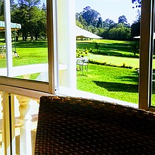
The breakfast room at Eldoret Club, overlooking the golf course
Daima Towers
At 26 floors and 70 metres (230ft) tall, this is the tallest building in Kenya west of Nairobi and stands as a landmark of the town. It was built by the Moi University Pension Scheme[44] and was opened in 2016.[45]
The building features a rooftop restaurant as well as a variety of boutiques and office spaces.
Eldoret Club
Eldoret Club is a private members club that was established in 1924 on the edge of town. It is situated on large well-manicured grounds that house a clubhouse, a 9-hole golf course and a variety of other facilities.[46]
Athletics Training Centres
Athletics is by far the most popular sport in the region with wins at the Olympics and World Athletics Championships as well as road races across the world having propelled many local residents to stardom and financial success. Current and future athletes can be seen training at the IAAF High Altitude Training Center and other privately run training centers, the Kipchoge Keino stadium or even along the streets on most mornings.
Education
Catholic University of East Africa
Eldoret is home to Moi University. Though the university's main campus is located about 30 kilometres (19mi) away in Kesess, located due South, four of its campuses are within the town limits of Eldoret. These campuses are; Annex Campus (School of Law), Town Campus (School of Medicine and School of dental sciences), Rivatex Campus (School of aeronautical engineering) and Eldoret West campus (for privately sponsored students) a student population of 14,855 as of 2006.
The University of Eldoret is the second largest university in the city having been awarded its charter in 2013. Its main campus is located within the city limits to the north of the town.
Other universities with campuses in the town include Catholic University of East Africa, Jomo Kenyatta University, University of Nairobi, University of East Africa - Baraton, Kabarak University, Mount Kenya University and Kisii University
The city also is home to many technical and vocational institutes including Rift Valley Technical Training Institute, Eldoret National Polytechnic, African Institute for Research and Applied Studies.
Health
There are a number of medical facilities in the city, notably Moi Teaching & Referral Hospital; The only referral national hospital in western Kenya. The town has the Uasin Gishu District Hospital, and there are several private institutions: St. Luke Orthopaedic And Trauma Hospital, Eldoret Hospital, Mediheal Hospital, Eldoret Oncology Associates Cancer Hospital, Reale Hospital, Alexandria Cancer Centre and Palliative Care Hospital and Elgon View Hospital among others.
In 2015, East & Central Africa's first public children's hospital, The Shoe4Africa Children's Hospital, a 200-bed general teaching hospital, was opened, behind the Moi Referral.
Also in 2015, a new out patient cancer treatment centre was opened at the Moi Teaching and Referral Hospital, funded principally by Ruth Lily, an American philanthropist. It has been named after the businessman, Manu Chandaria, a later funder, and is now known as The Chandaria Cancer and Chronic Disease Centre.[47]
Sport
Eldoret, in particular the Elgon View area, is the hometown of numerous Kenyan runners, the most renowned of whom are Kipchoge Keino and Eliud Kipchoge. The high altitude is an ideal training ground for many middle and long distance athletes.
KCB Safari rally
Kipchoge Keino Stadium is the town's main stadium and is a multi-use stadium with a capacity of 10,000 people. The stadium is used for athletic meetings and hosts local football teams including Rivatex and Eldoret KCC. The stadium fell into disrepair and was refurbished beginning in 2007 when the Kenyan Government allocated Ksh100million for its upgrade.[48] In 2018, it began going through a second major expansion and renovation.
Eldoret Falcons is a women's football team that represents the city in the nationwide league while Eldoret RFC is a men's rugby team in the nationwide league. The city has also been a popular stage in the KCB Safari Rally.
The town is home to the Eldoret City Marathon, whose $35,000 winners purse during its second edition in 2019 made it the richest marathon race in Africa.[49] The event is organised by the Uasin Gishu county government and is patronized by the County Governor, H.E Jonathan Kimeli Bii Chelilim and John Kibet Barorot.[50]
The town is also host to a leg of the annual national sevens circuit rugby tournament. The Eldoret leg is played in June and referred to as the Sepetuka Sevens. It is extremely popular and brings the city to a halt for the entire weekend with fans coming into the city from all over the country.
Eldoret Club, a golf club is located a short distance from its CBD.
Infrastructure
Transport
Airports
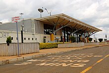
Entry to the main lounge of Eldoret International Airport
The town of Eldoret is served by two aerodromes, Eldoret International Airport and Eldoret Airstrip.
Eldoret International Airport is a regional airport approximately 14km (8.7mi) from Eldoret city. It has daily scheduled flights to Nairobi and Lodwar and weekly international cargo flights operated by Emirates and Etihad Airways. Situated at 6,941 feet (2,116m) above sea level,[51] the airport has a single asphalt runway that measures 3,475 metres (11,401ft) in length.[52]
Four domestic airline companies operate in this airport: Fly 540, Jambojet, Skyward Express and Silverstone Air.
The Eldoret Airstrip, also known as the Eldoret Boma Airport, is a small airstrip located within Eldoret on the Eldoret Iten road. It has an elevation of 7,050ft above sea level and a single runway measuring 1,130 metres (3,710ft). The county government of Uasin Gishu took over operations of the Eldoret airstrip in July 2015 County to take over Eldoret airstrip July 1
Roads
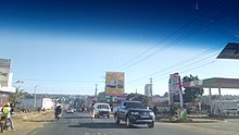
Vehicles leaving Eldoret, near Sosiani primary school.
The Trans-African highway passes through the town's central business district.
Railway
The town is also served by the Kenya-Uganda railway.
Power
The French renewable energy firm Voltalia is building a 40-megawatt (MW) solar plant for compatriot Kenya-based French solar firm Alten Africa in Kesses, Eldoret. Once it goes into commercial operation, scheduled for March 2020, approximately 123.6GWh of clean electricity will be injected into the grid every year, enough to meet the annual energy consumption needs of over 824,000 Kenyans.[53]
Oil pipelines
The Kenya Pipeline Company operates a pipeline that passes through the town. It is connected to the refinery at the coastal city of Mombasa and extends further from Eldoret to the lakeside city of Kisumu. One of 5 national oil depots is located in the town.
Kipchoge Hezekiah Keino is a retired Kenyan track and field athlete. He was the chairman of the Kenyan Olympic Committee (KOC) until 29 September 2017. A two-time Olympic gold medalist, Keino was among the first in a long line of successful middle and long distance runners to come from the country and has helped and inspired many of his fellow countrymen and women to become the athletics force that they are today. In 2000, he became an honorary member of the International Olympic Committee (IOC). In 2012, he was one of 24 athletes inducted as inaugural members of the IAAF Hall of Fame.
The Kalenjin are a group of tribes indigenous to East Africa, residing mainly in what was formerly the Rift Valley Province in Kenya and the Eastern slopes of Mount Elgon in Uganda. They number 6,358,113 individuals per the Kenyan 2019 census and an estimated 273,839 in Uganda according to the 2014 census mainly in Kapchorwa, Kween and Bukwo districts.
Trans-Nzoia County is a county in the former Rift Valley Province, Kenya, located between the Nzoia River and Mount Elgon, 380 km northwest of Nairobi. At its centre is the town of Kitale which is the capital and largest town. The county borders Bungoma to the west, Uasin Gishu and Kakamega to the south, Elgeyo-Marakwet to the east, West Pokot to the north and the Republic of Uganda to the Northwest. Trans Nzoia covers an area of 2495.5 square kilometres.
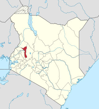
Uasin Gishu County is one of the 47 counties of Kenya located in the former Rift Valley Province. Eldoret has the county's largest population centre as well as its administrative and commercial centre. "It lies between longitudes 34 degrees 50' east and 35 degrees 37' West and latitudes 0 degrees 03' South and 0 degrees 55' North. It is a highland plateau with altitudes falling gently from 2,700 meters above sea level to about 1,500 meters above sea level. The topography is higher to the east and declines gently towards the western border".
Nakuru is a city in the Rift Valley region of Kenya. It is the capital of Nakuru County, and is the third largest urban area in Kenya. As of 2019, Nakuru has an urban population of 570,674, making it the largest urban centre in the Rift Valley, succeeding Eldoret, Uasin Gishu County. The city lies along the Nairobi–Nakuru Highway, 160 kilometres (99 mi) from Nairobi.
Moi University is a public university located in Kesses, Eldoret town, Uasin Gishu county, in the former Rift Valley Province of Kenya. It was established in 1984 by the Moi University Act of the Parliament of Kenya, after recommendations from the McKay Commission.
Nandi County is a county in Kenya in the North Rift, occupying an area of 2,884.4 square kilometres. Its capital, Kapsabet, is the largest town in the county while other towns include Mosoriot, Tinderet, Kobujoi, Kaiboi, Kabiyet and Nandi Hills. According to a 2019 census, the county has a population of 885,711, made up of a number of Kenyan communities, the majority of whom belong to the native tribe called Nandi.
Kaptagat is a settlement in Uasin Gishu County, in the southwestern part of Kenya. This part of the country, where the two counties of Uasin Gishu and Elgeyo Marakwet County share a border, is used by the majority of Kenyan professional long-distance runners to train for professional competition. Eliud Kipchoge, the former marathon world record holder, who also doubles as the Tokyo Olympics and Rio Olympics marathon gold medalist, maintains a training camp in Kaptagat.
Kipchoge Keino Stadium is a multi-use stadium in Eldoret, Kenya. It is named after the athlete Kipchoge Keino. It holds 10,000 people.
Eldoret Airport is an international airport in Kenya.
Moi Teaching and Referral Hospital was started in 1916 with a bed capacity of 60 to cater for the Africans Health Needs. It later served as a District Hospital before attaining referral status vide Legal Notice No. 98 of 12 June 1998 of the State Corporations Act. Currently, the Hospital serves as a level six Hospital offering outpatient, inpatient, and specialized healthcare services. It is located along Nandi Road in Eldoret Town, Uasin Gishu County. The Hospital serves residents of Western Kenya, parts of Eastern Uganda and Southern Sudan with a population of approximately 24 Million.
Sub-counties, also known as Districts, are the decentralised units through which government of Kenya provides functions and services. At national level, sub-counties take a more administrative function like security, statistical purposes, provision of government services, etc. Even though the sub-counties are divisions of counties, powers to create new national sub-counties lies with the national government. As of 2023, there are 314 sub-counties, compared to 290 constituencies. A deputy county commissioner is appointed by the state to lead each sub-county. The sub-counties are further divided into divisions, locations and sub-locations.
Elgeyo-Marakwet County is one of Kenya's 47 counties, which is located in the former Rift Valley Province with its capital and largest town as Iten. It borders the counties of West Pokot to the north, Baringo County to the east, southeast and south, Uasin Gishu to the southwest and west, and Trans Nzoia to the northwest.
Uasin Gishu District, also known as Eldoret District, was one of the districts of Kenya, located in the Rift Valley Province. The town of Eldoret was its capital, administrative and commercial centre. It bordered the Trans-Nzoia District.
Rift Valley United Football Club is an association football club based in Eldoret, Kenya. The club currently competes in the Kenyan National Super League, and was known as Hotsprings Football Club until 31 March 2014.
Eugenie Dorothy Hughes, was a Kenyan architect, politician, social reformer and disability activist. She founded the Kenyan Council of Social Services and served as the head of the Sports Association for the Disabled. As the first East African female architect, she owned her own firm and is best known for her design of the Cathedral of the Holy Family in Nairobi.
The Nairobi–Malaba Road, also Nairobi–Uganda Road or A104 Road (Kenya) is a major highway in Kenya, the largest economy in the East African Community. The road connects Nairobi, the capital and largest city in Kenya, with the border town of Malaba at the international border with Uganda.
Turbo is a town at the border of Uasin Gishu County and Kakamega County Kenya, approximately 34 kilometers northwest of Eldoret Town, along the Nairobi-Malaba Road. Turbo Constituency derives its name from this Town. The town is connected to other trading centres in both counties by a complex road network.
The Sirikwa culture was the predominant Kenyan hinterland culture of the Pastoral Iron Age, c.2000 BP. Seen to have developed out of the Elmenteitan culture of the East African Pastoral Neolithic c.3300-1200 BP, it was followed in much of its area by the Kalenjin, Maa, western and central Kenyan communities of the 18th and 19th centuries.
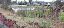
Kesses Dam is a small man-made lake in Kenya. It is one of the sources of the Yala River. It is used as a source of water for irrigation and domestic use, and also for boating and other water activities.
↑ "STATIONSNUMMER 63686"(PDF). Ministry of Energy, Utilities and Climate. Archived from the original on 16 January 2013. Retrieved 4 November 2016.{{cite web}}: CS1 maint: bot: original URL status unknown (link)
This page is based on this Wikipedia article Text is available under the CC BY-SA 4.0 license; additional terms may apply. Images, videos and audio are available under their respective licenses.