The Nile has two major tributaries: the White Nile and the Blue Nile. The White Nile is longer and is considered to be the headwaters, although the Blue Nile contributes over two thirds of the water and silt below the confluence of the two. The White Nile begins at Lake Victoria and flows through Uganda and South Sudan; and the Blue Nile begins at Lake Tana in Ethiopia and flows into Sudan from the southeast. The two rivers meet at the Sudanese capital of Khartoum. From there, the river flows north, through the Nubian Desert to Egypt's capital city, Cairo, finally emptying into the Mediterranean Sea near Alexandria, where it has formed a large delta.
Geologically, the Nile is a young river, and has only flowed in its present course for about 12,000 years. The river's drainage basin covers portions of eleven countries. Most of the water in the Nile comes from rainfall in upstream countries of Ethiopia, Kenya, Tanzania, and Uganda. Downstream countries (Egypt, Sudan, and South Sudan) are primarily desert, and withdraw river water for irrigation. Other countries in the Nile Basin are Burundi, Democratic Republic of the Congo, Eritrea, and Rwanda.
The Nile was the foundation of the Ancient Egyptian civilization, which relied on the river for nearly every aspect of life. The annual flooding of the river deposited silt along the riverbanks, which supported crops that enabled a flourishing society to thrive in an otherwise inhospitable desert. The Nile facilitated trade, communication, transportation, and governance. In the Ancient Egyptian religion, the river was personified by Egyptian gods Hapy and Khnum. The source of the Nile was not definitively identified until the late 19th century, when Europeans explored the region around Lake Victoria.
In the modern era, the Nile plays a critical role in the economy of countries in the Nile basin, particularly Egypt and Sudan who rely on the river to irrigate extensive croplands. Since the late 20th century, over a dozen dams have been built in the Nile Basin to provide for irrigation and to generate electricity. The dams have altered the river's annual flood cycle and restricted the transportation of silt downstream, which may cause the Nile Delta to shrink. Some dams–such as the Aswan High Dam and Grand Ethiopian Renaissance Dam–have been the source of international political disputes about irrigation, safety, food security, and forced displacement of peoples.
Names and etymology
The English word "Nile" is derived from the LatinNilus and the Ancient GreekΝεῖλος (Neilos), which possibly originated from the Semitic term naḥal, meaning 'river'.[6]
In the ancient Egyptian language, the same word was used for 'Nile' and 'river': jtrw.[7] The Nile was also called Ar or Aur meaning 'black'–in reference to the dark color of the Nile floodwaters as they carried sediment from upriver.[6][c] The Coptic language in Egypt, which is no longer spoken, but still used for liturgical purposes, also refers to the river with the word for 'black': ⲫⲓⲁⲣⲟ.[6] The English name of the Blue Nile is a mistranslation of the Sudanese Arabic name Nil Azrag, which means 'black Nile'.[9][d]
In the modern era, the river goes by several names within the Nile Basin. In Egypt, its names use the Arabic word النيل (romanized as 'Nil') in the forms Al-Nīl, Baḥr Al-Nīl or Nahr Al-Nīl.[10][e] In South Sudan, it is sometimes referred to by the Arabic Baḥr el-Jebel, بحر الجبل, literally 'Mountain River'.[11] In Uganda, the speakers of Luganda use the name Kiyira.[12] Some Nubian peoples of Egypt and Sudan use the Nobiin name Áman Dawū ('Great Water').[13]
Several tributaries (smaller rivers that merge into the Nile) and segments of the river incorporate "Nile" in their name, including:
Albert Nile–Segment of the White Nile flowing north from Lake Albert[14]
Victoria Nile–Segment of White Nile from Lake Victoria to Lake Kyoga[19]
White Nile–One of the two major tributaries of the Nile River
Yellow Nile–The Wadi Howar, remnant of an ancient tributary that dried up several thousand years ago[17]
Geography
The waters of the Nile originate as rainfall in the mountains in the south and east regions of the Nile Basin.
The Nile River is a major river in northeastern Africa which flows into the Mediterranean Sea. The Nile Basin is all land that drains into the Nile River (see adjacent map). Eleven countries are wholly or partially within the basin: Burundi, Democratic Republic of the Congo, Egypt, Eritrea, Ethiopia, Kenya, Rwanda, South Sudan, Sudan, Tanzania, and Uganda.[20][g] The basin covers a wide variety of climates, ecosystems, and topographies–ranging from arid, sandy deserts in the north, to flat, swampy wetlands in the middle, to rainy, forested mountains in the south.[22]
The basin can be divided into seven regions; five of these regions encompass the longest course of the Nile River. Proceeding in a downstream sequence, these five regions are: the African Great Lakes, the Mountain Nile, the White Nile, the main Nile, and the Nile Delta. Two additional regions encompass major tributaries: the Blue Nile and the Atbarah River.[6]
African Great Lakes
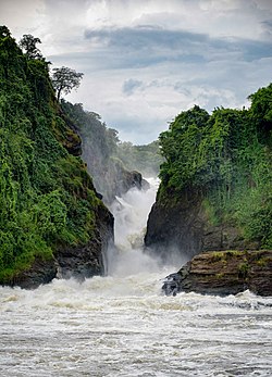
The African Great Lakes region contains the source of the Nile river as well as several large lakes that are part of the Nile river system: Lake Victoria, Lake Albert, Lake George, and Lake Edward.[23] The source of the Nile is the Rukarara River within Rwanda's Nyungwe National Park,[2] and it leads to the Kagera River which drains into Lake Victoria.[6][h] Although it is a large lake–the second-largest freshwater lake in the world[i]– Lake Victoria is relatively shallow, with an average depth of 40 meters.[25] The Nile river first assumes the name "Nile" where Lake Victoria empties on its north side: the course from there to Lake Albert is called the Victoria Nile.[6] A pair of waterfalls–Ripon Falls and Owen Falls– were located where the Nile exits Lake Victoria, but have both been submerged by the construction of the Nalubaale dam. After Bujagali Falls and Bujagali Power Station, the Victoria Nile empties into Lake Kyoga. After exiting Lake Kyoga, the river is joined by the River Kafu tributary, then passes over Murchison Falls and flows into Lake Albert. Unlike Lake Victoria, Lake Albert is a deep lake surrounded by mountains. The river exits Lake Albert on its north shore, where it is called the Albert Nile; this stretch of the river is relatively flat and broad, and suitable for navigation by steamboats.[26]
Mountain Nile
The second region of the Nile Basin, proceeding downstream, is the Mountain Nile (Arabic: Bahr al Jabal).[27] This region begins near the town of Nimule and extends to Lake No, and is entirely within South Sudan. After passing through Nimule, the river goes through the Fula Rapids and on to Juba–the capital city of South Sudan. After Juba, the Nile passes through the town of Bor, then enters the Sudd, a large swamp located in a flat plain. The incline of the ground in the Sudd is only 1:13,000 rise over run, so the river slows down and widens. Lush vegetation, including sedges, papyrus, and common water hyacinth (an invasive species) clog the waterways and make navigation difficult. At the downstream edge of the Sudd swamp, the Nile is joined by the Bahr el Ghazal River (Arabic: 'gazelle river') a tributary flowing from the west. This confluence happens in Lake No.[26]
White Nile region
Continuing downstream, the third region of the Nile Basin is the White Nile region[j] which includes an 800 km stretch of river from near Malakal to Khartoum, the capital of Sudan. There it is joined by the Blue Nile. This portion of the river is a wide, calm stream with a fringe of swamps on both banks. The river here is shallow and undergoes significant losses due to evaporation.[6]
Main Nile
The Aswan High Dam is located on the main Nile near the border between Egypt and Sudan. Its electrical generators have the capacity to produce 2.1 gigawatts.
The fourth region of the Nile Basin–the main Nile[k]–extends from Khartoum to Cairo, the capital of Egypt. Soon after leaving Khartoum, the river enters the Sabaloka Game Reserve and goes through large, powerful rapids that are impassible by boat. This is the sixth (and furthest upstream) of the renowned six cataracts of the Nile. The Atbarah River–a major tributary–joins the Nile, which then follows a large S-shape curve to the west. Four more cataracts are encountered in this large S-curve, which render the river unnavigable; although ships may travel in certain calm stretches between the cataracts. The river then enters a reservoir: Lake Nasser.[l] This lake– the world's second largest man-made lake–was formed when the Aswan High Dam was built in Egypt, and inundates more than 480km of the Nile river. The Aswan Low Dam–older and smaller than the High Dam– lies beneath the Aswan High Dam, near the location of the first Nile cataract (now submerged). From these dams, the Nile flows about 800km through a limestone plateau, bordered by large amounts of irrigated farmland, until it reaches Cairo.[26]
The Nile Delta is the large triangular vegetated region at the top of this photograph, where the river empties into the Mediterranean Sea.
The fifth, and final, region encompassing the Nile river is the Nile Delta, a large triangular river delta (about 22,000km2[31]) that extends from Cairo to the Mediterranean Sea.[6] The river splits into two major distributaries (channels) within the delta: the Rosetta branch and the Damietta branch. The width of the underwater portion of the Nile delta is 320 km, and it reaches into the Mediterranean Sea to a depth of 1,800 m. The total volume of the delta (including the submerged portions) is about 150,000km3. The delta was created over several million years, built-up from sediment carried down the river from upstream.[32] Since the Aswan High Dam was completed in 1970, the delta has begun to shrink due erosion caused by currents in the Mediterranean Sea. In the past, erosion was balanced by new soils arriving in the form of sediment carried by the river; but the dam traps sediment in its reservoir, preventing new soil from reaching the delta.[33][m]
The final two regions of the Nile Basin are drainage basins of two tributaries: the Blue Nile basin and the Atbarah River basin.[6]
Tributaries
The longest course of the Nile, which includes the White Nile tributary, has several other tributaries that feed into it.
The source of the Blue Nile is Gish Abay at the bottom of the bright line. The river flows north from there to Lake Tana at the top.
The Blue Nile springs from hills in Ethiopia where it originates as a stream named Abay near the town of Gish Abay: Gish in an Amharic word meaning 'source', and Abay is the name of the stream.[34] Gish Abay flows into Lake Tana, a large, shallow lake, which has a single outflow where it adopts the "Blue Nile" name. The river then makes a wide loop: first south, then west through a spectacular gorge 2km deep, then north passing through South Sudan into Sudan, where it joins with the White Nile at Khartoum to form the main Nile.[35] Along its course, the Blue Nile generates electricity at several hydro power plants, including the Tis Abay hydropower project at the Blue Nile Falls, the Grand Ethiopian Renaissance Dam near the border between Ethiopia and South Sudan, the Roseires Dam near town of Ad Damazin, and the Sennar Dam.[36] The size of the Blue Nile's drainage basin is over 306,000 square km.[37]
The Atbarah River is a tributary of the Nile which arises in northern Ethiopia, and joins the Nile about 320km north of Khartoum.[38] Its drainage basin covers over 204,000 square km.[37] The Atbarah has a heavy flow during and following the monsoon season in Ethiopia (summer and fall), but can dry up in the winter and spring. Despite the intermittent nature of the river, it provides more than 10% of the total annual flow of the Nile.[38] Dams on the Atbarah include the Khashm el-Girba Dam, the Upper Atbara and Setit Dam Complex, and the Tekezé Dam (on the Tekezé River tributary).[39]
Bahr el Ghazal and Sobat River
The Bahr al Ghazal and the Sobat River are two tributaries of the White Nile. The Bahr el Ghazal arrives from the west, joining the White Nile at Lake No. The drainage basin of the Bahr el Ghazal river is large–about 860,000 square km[40]–and receives a relatively large amount of rain, but its contribution to the Nile is small compared to other tributaries.[n] Its basin includes Lake Kundi and Lake Keilak. The Bahr el Ghazal passes through the city of Wau, South Sudan: it is a permanent stream east of Wau, but a seasonal stream to the west.[41]
Another tributary, the Sobat River, joins the White Nile (after the Bahr el Ghazal confluence, before the Blue Nile) near the town of Malakal. Its basin–which includes the Machar Marshes[11]–covers about 225,000 square km.[42] The Sobat floods between July and December.[6]
Lake Victoria is sometimes informally described as the source of the Nile, partly because early European explorers stated that the lake was the source; and partly because the lake's outflow river is the most upstream river called the "Nile" (rivers flowing into Lake Victoria, such as the Kagera River, do not have the word "Nile" in their names).[46][s] Some have suggested that the genuine source of the Nile is the rain clouds that are often found above Lake Victoria, because they supply five times more water to the lake than the lake's inflow rivers.[44]
The annual contributions to the main Nile from the three primary tributaries are: 54% from the Blue Nile, 32% from the White Nile (including contributions from the Bahr el Ghazal and Sobat tributaries), and 14% from the Atabarah.[52] Thus, the proportion of water from the Ethiopian Highlands is about 68% (the Blue Nile and Atbarah arise in Ethiopia), and the proportion from the African Great Lakes region (source of most of the White Nile) is about 32%.[52][w]
The highlands of the White Nile and Blue Nile both experience seasonal rain, but the White Nile's flow into the main Nile is much more constant than the Blue Nile.[6] This is due to the many lakes and wetlands on the White Nile, which moderate the cyclic effects of seasonal rainfall.[55] The White Nile passes through the Sudd swamps before it reaches the Blue Nile; about half the water flowing into the Sudd is lost to evaporation before it flows out.[56]
In contrast, the flow of the Blue Nile varies widely through the year: it floods between July and October, due to summer monsoon rains.[6] The waters of the Blue Nile are so substantial during the summer and autumn, that the White Nile backs-up during this time at the confluence.[57] During the summer floods, the contributions to the main Nile are about 70% from the Blue Nile, about 20% from the Atbarah, and about 10% from the White Nile.[6] At the peak of the flood, the daily flow into Lake Nasser is about 0.71km3, about three times the annual daily average of 0.23km3 per day.[58]
As the Blue Nile flow diminishes in the winter, the pent-up waters of the White Nile increase their flow past Khartoum.[59] In April and May, the White Nile supplies about 80% of the main Nile's water. Thus, the areas downstream of Khartoum receive a steady (not to say constant) flow that made irrigation possible year-round.[59]
Prior to the construction of dams on the Nile, the flow of the Nile in Egypt varied seasonally: higher in the summer/fall; lower in the winter/spring. However, following the construction of the Aswan High Dam–which created a reservoir that can hold about two years of river flow– the flow downstream from that dam is now more constant year-round.[60][x]
Sediment transport
The Nile carries sediment downstream. The movement of sediment is classified as suspended sediment (particles suspended in the water) or bedload (sediment on the river bottom that rolls or tumbles downstream).[62]
Ninety-seven percent of the transported sediment carried by the Nile comes from the Atbarah and Blue Nile, both of which originate in Ethiopia.[63] The erosion and transportation of silt only occurs during the Ethiopian rainy season when rainfall is especially high in the Ethiopian Highlands; the rest of the year, the major rivers draining Ethiopia into the Nile have a weaker flow.[6] The cumulative amount of rock eroded in the past 30 million years from the Ethiopia headwaters of the Nile is about 102,000 km3, which is roughly comparable to the volume of the soil in the Nile Delta (including the underwater portion) which is about 150,000 km3.[64]
Sediment carried by the Nile, or its tributaries, into a reservoir has the potential to settle in the reservoir and reduce the storage capacity of the reservoir. Sediment accumulated behind the Sennar Dam, Roseires Dam (on the Blue Nile), and Khashm el Girba Dam (on the Atbarah) has significantly reduced the storage capacity of their reservoirs since they were built.[65]
Annual sediment transport measured at several locations are listed below.[66][y] The bedload percentages are the ratio of bedload sediment to total (bedload and suspended) sediment. These data were collected before the construction of the Grand Ethiopian Renaissance Dam, which has a significant impact on sediment loads downstream of the dam.[66]
Gilgel Abay, Ethiopia: 7.6 million tonnes of suspended, and an additional 0.7% of bedload
El Deim (at the border of Ethiopia and Sudan): 140 million tonnes[65]
Aswan, Egypt: 0.14 million tonnes of suspended, and an additional 28% of bedload
Beni Sweif, Egypt: 0.5 million tonnes of suspended, and an additional 20% of bedload
Qena, Egypt: 0.27 million tonnes of suspended, and an additional 27% of bedload
Sohag, Egypt: 1.5 million tonnes of suspended, and an additional 13% of bedload
Water sources and sinks
Water balance in the Nile basin is analyzed using hydrology: water input from rain is balanced by water output to the soil, evaporation, and streams.
Some regions in the Nile Basin contribute to the river's flow, and other regions take from the river. A region is a "source" if the region is contributing water to the rivers passing through; conversely, a region is a "sink" if the region is removing water from the rivers passing through.[67][z] Identifying sources and sinks is important to scientists that study water movement (hydrology), as well as policy makers that negotiate water sharing issues.[68]
The regions of the Nile basin that are water sources are the upstream areas including the Ethiopian Highlands and the African Great Lakes region. The water sink areas are generally found in the downstream regions, including South Sudan, Sudan, and Egypt.[69][aa]
The water balance methodology is employed to determine which regions are sources and which are sinks. Water balance is a hydrological principle that states that the water entering a region is balanced by the water leaving a region.[70][ab] For a given region, hydrologists measure (or estimate) precipitation, evaporation, transpiration, groundwater recharge, lake-filling rate, and net streamflow. Evaluating these values will indicate if a region is a source or a sink. Generally, a region is a source if the net streamflow is positive; conversely, a region is a sink if the net streamflow is negative.[71][ac]
Sources and sinks: countries
The following table summarizes water balance measurements for countries within the Nile basin. Portions of countries outside the Nile Basin are excluded from the values. The "Source or Sink" column shows one of these values:
Source–The country is a significant water source
Sink–The country is a significant water sink
Neutral–The country is not a significant source or sink
Most of the per-basin data is presented as annual measurements (usually in km3); but some data is also presented as an equivalent "depth" value (millimeters per year, covering the entire basin).[49]
The water balance tables of this article contain water flow information measured at the twelve stations shown in this map.
Another way of analyzing the water balance of the Nile river is to partition the basin geographically (ignoring national boundaries). The following tables split the Nile basin into twelve smaller basins, and summarize the water balance data of each of the smaller basins. The data is based on measurements made at a dozen river measurement stations.[49][af] The stations divide the Nile basin into smaller basins. These basins are each named after their downstream station. For example, the Murchison Falls station (2) is downstream of the Lake Victoria outlet station (1), so the basin between them is named the Murchison Falls basin.[73][af]
The basin data in the table is for each individual basin; it is not cumulative. For example, the runoff of station 5 is the runoff for the basin between stations 4 and 5, and excludes runoffs from upstream basins (1,2,3). The measuring stations are listed in the following tables proceeding from upstream to downstream. The discharge "rate" data is an average of the entire year.
Measurements of the Nile's flow has always been essential to help Egyptians manage their safety and irrigation. Simple gauges, called nilometers, have been used for thousands of years to measure the level of the Nile.[76] An important nilometer has been in use on Roda Island since at least 622 AD; Egyptians kept records of maximum and minimum river levels from that gauge until 1921.[77] Modern gauges to measure the river level began to be installed in the 1860s, and gauges that also measure the river's current–which provide more accurate flow information–were installed beginning in 1900.[77]
The total number of fish species found in the Nile Basin is estimated at over 800. In the river alone, 128 species are found, belonging to 27 families.[78] The majority of species belong to the four families: Cichlidae (cichlids), Cyprinidae (carp), Mormyridae (elephantfish), and Mochokidae (catfish).[79] A number of Cichlid species are found in the African Great Lakes.[78]
Birds that live on or near the Nile include herons, kingfishers, ospreys, and various kinds of storks–including shoebills.[80] Some of the bird species are endemic to the Nile basin (such as blue-winged goose), while other species have a cosmopolitan distribution (including moorhen and osprey).[82] Several species of heron, ducks, geese, and egrets live in the basin year-round, and 14 species of ducks and geese arrive only for winter residence.[82] Of the gulls and terns in the basin, the vast majority are migratory. During the past thousand years, the ranges of some species have been reduced, probably due to human encroachment on habitat.[82]
The Great Lakes region of the Nile Basin includes plants such as the water lily, papyrus, and water hyacinth. The water hyacinth is an invasive species, and has adversely impacted the populations of native species in Lake Kyoga.[84] Plants common in the Sudd swamp include species that thrive in deep flooding such as Vossia, hippo grass, reed mace, ambatch, and papyrus. The Sudd also hosts species that thrive in shallow flooding, for example Oryza, antelope grass, and Phragmites.[85]
Pollution
Historically, the water of the Nile was noted for being drinkable, but in the late 20th century, it became less healthy in certain areas.[86] Lake Tana is polluted with industrial pollution; portions of the river near population centers (such as Khartoum and Cairo) are polluted with industrial pollutants and sewage; ships contribute pollutants to the waters; and industrial plants in Egypt dump waste into the river.[87]
Sources of pollution in the Nile include agricultural, industrial, and household waste. There are 36 industries that discharge their pollution sources directly into the Nile, and 41 into irrigation canals. These types of industries are: chemical, electrical, engineering, fertilizers, food, metal, mining, oil and soap, pulp and paper, textile and wood. There are over 90 agricultural drains that discharge into the Nile that also include industrial wastewater.[88]
River pollution is most pronounced between Aswan and the Mediterranean Sea. The pollution there comes from human activities, agricultural runoff, and industrial waste. The river delta contains Egypt's primary oil and gas production facilities, and the chemical industry in the delta is the single largest contributor of toxic waste to the Nile. Concentrations of pollutants increase as the river flows downstream, due to the cumulative effects of pollution sources.[89] The Nile delta has relatively high levels of heavy metal concentrations. The delta is susceptible to accumulated concentrations because of poor flushing actions, exacerbated by a flat topography and heavy silting in the riverbed.[90] The northeast region of the delta is the most polluted part of the river in Egypt, and has a high incidence of pancreatic cancer, which may be related to high levels of heavy metals and organochlorine pesticides found in the soil and water.[91]
In the late 20th century, Lake Victoria experienced increased eutrophication resulting in excessive plant growth, which depletes oxygen levels in the water. The eutrophication is due to human activity, deforestation, and poor agricultural practices, and has caused algal blooms and a rapid proliferation of water hyacinth, which have disrupted the ecosystem.[92]
The Nile Basin was relatively wet and humid from 15 thousand years ago (KYA) to 5 KYA, which enabled the start of large-scale agriculture in the Nile Basin around 5 KYA. The growth of agriculture has had an increasing impact on the environment since then, leading to widespread deforestation and soil erosion.[93] The impacts were worsened by drier conditions in Africa that started about 4 KYA. These arid conditions led to famines and social disruption, and also to increased environmental degradation.[93]
Several species of animals have become extinct in the Nile Basin due to human activity. The sacred ibis was important in the ancient Egyptian religion, and millions of the ibis were ritually sacrificed, leading to the eventual extinction of the species in Egypt. The bird remains common in central and southern Africa.[94]
The Nile perch was native to several places in Africa, including the Congo, but was not present in the Nile river or its lakes until it was surreptitiously introduced to Lake Victoria in the 1950s to create a fishing stock.[95][ap] The Nile perch caused the extinction of over 500 species of cichlids in Lake Victoria, which scientist Les Kaufman described as the first mass extinction of vertebrates that scientists have had the opportunity to observe.[95][aq] The Nile perch also led to increased deforestation, because firewood was required to process the fish.[97]
The satellite lakes of Lake Kyoga are potentially important for future conservation efforts, because they contain at least 60 species of haplochromines, and have not yet been invaded by the Nile perch.[81]
This map shows the Köppen climate classification zones in the Nile Basin and the surrounding region. The northern part of the basin is a hot, dry desert (Bwh) while the south is cooler and wetter (C and A zones).[98]
The climate of the Nile Basin is defined by a pronounced transition: very dry in the north, becoming progressively wetter to the south.[99] The basin can be divided into nine distinct rainfall regions: the northern regions (Egypt and Sudan) are very dry all year; the middle regions (including Ethiopia) have strong peaks of rainfall in the summer; and the southern regions (around Lake Victoria) have two rainfall peaks–in spring and fall.[100] The majority of the rainfall in the Nile Basin is associated with the summer monsoon.[101]
The Nile Basin is experiencing climate changes related to the increasing prevalence of greenhouse gases in the atmosphere.[102] Some projections for the 21st century predict a temperature increase of 2 to 4°C.[102] The Blue Nile basin in Ethiopia has been experiencing significant changes in temperature and precipitation since the 1970s. In a review published in 2024, scientists predicted that temperatures would continue to rise. Rainfall is fluctuating and impacting crop production, but future trends are uncertain.[103]
Models of the future climate in the North Africa and Middle East region predict an increase in frequency and severity of both dryness and drought, and increasing variability of precipitation.[104] The Nile Delta is particularly vulnerable, and the combined action of sea level rise and lack of sediment replenishment (due to dams on the Nile) may cause one third of the surface area of the Nile Delta to disappear within the next century.[105]
Geological data, as seen in this map of northeast Africa, are used by geologists to reconstruct ancient topography and water flows.
The Nile River that exists today is the result of a gradual evolution of older river systems, which followed courses much different than the modern Nile. Over millions of years, tectonic and environmental forces have shifted, separated, and merged rivers, eventually producing the current river.[107] Geologists have hypothesized various evolutions of the Nile; one theory divides its history into three stages: (1) Pre-Egyptian Nile, (2) Ancestral Egyptian Nile, and (3) Modern Nile.[108][ar]
Pre-Egyptian Nile
The Pre-Egyptian Nile stage, which occupies the period before 6 million years ago (MYA). In that era, rivers in Egypt generally flowed from the region near the Red Sea towards the west, rather than to the north (as the modern Nile does).[109]
Ancestral Egyptian Nile
The Ancestral Egyptian Nile stage, which spanned the era from 6 MYA to 12 KYA. In this period a major river in Egypt formed and began to flow north to the Mediterranean Sea, establishing the ancestor of the modern Nile.[110] A critical event of this era was the Messinian salinity crisis, which lasted from roughly 6 MYA to 5 MYA. During this crisis, the Strait of Gibraltar was closed, and the Atlantic ocean could no longer fill the Mediterranean Sea, so the Sea completely evaporated. The empty Mediterranean caused the ancestor Nile to cut a deep gorge: eroding a canyon several hundred meters below world ocean level at Aswan, and 2,400 meters below at Cairo. This very long and very deep canyon later became filled with sediment after the Mediterranean was refilled.[111]
Modern Nile
The modern Nile–the third stage–started around 12 KYA when the Nile began to approximately follow its current course. This was the result of tectonic shifts (starting around 30 KYA) in the African Great Lakes region, which caused that region to begin to tilt northward and drain into Egypt. Around 12 KYA, the lakes Tana, Albert, and Victoria started to flow northward approximately into the current course of the Nile.[112] At roughly the same time–about 15 KYA–the summer monsoon shifted and substantially increased rainfall in the area of Lake Victoria and Lake Albert.[113] The high water levels of both the Blue Nile and White Nile have fluctuated over the past 15,000 years, with unusually high levels occurring several times between 15 KYA and the present.[114]
Ancient Egyptians used boats extensively for transport. This image is from the Tomb of Pairy.
The eastern Sahara–including Egypt and Sudan–was much wetter during the African humid period which lasted from about 10,000 to 5,000 years ago. Pastoral herding cultures developed during that period, but when the climate became dryer around 3,900 BC, people were forced to migrate to the Nile River valley to survive. This was the origin of the Ancient Egyptian civilization.[116]
The Nile was central to every facet of ancient Egyptian civilization: it provided life through the crops it watered, and it caused death when droughts caused crop failures and famine. The Nile encouraged the growth of science and government: irrigation, flood predictions and taxation all required new mathematical and administrative skills. Weather prediction and astronomy also developed as a consequence of the Egyptian's need to understand the river and its floods.[117]
The ancient Egyptian calendar was based on the flood cycle of the Nile. The year was divided into three seasons, each consisting of four months of thirty days each. The seasons were Akhet (literally, 'inundation'), Peret ('growing'), and Shemu ('harvest'). Akhet was the time of the year when the Nile flooded, leaving a new layer of fertile soil behind; Peret was the growing season; and Shemu was the harvest season when there were no rains.[118] The Nile influenced their language: compass directions were based on a person facing upstream: "up" was south; "left" was east, and "right" was west.[119] They sometimes referred to rain as 'Nile in the sky'.[120]
Ancient Egypt's southern boundary was–informally–at the river's first cataract (near Elephantine Island) because transportation beyond those rapids was difficult.[121] The Egyptians were familiar with the course of the Nile upstream to the sixth cataract (present day Khartoum), but apparently were not familiar with the river course (nor its source) beyond that.[122][as] The Nile led the Egyptians to build the world's first major dam– the Sadd el-Kafara ('dam of the infidels')–circa 2600 BC in an attempt to control flooding.[123][at]
The Nile was a major factor in the growth of the Roman Empire, which imported vast amounts of grain from Egypt, grown with the Nile's floodwaters.[124]
South of ancient Egypt, beyond the second cataract, lies Nubia, home to a series of cultures that developed along the Nile River. Earliest was the Kerma culture, extant from about 2600 BC to 1500 BC. Kerma culture was originally a pastoral, cattle-oriented culture, but gradually shifted to agriculture as the Sahara dried at the end of the African humid period.[125][au] Around 780 BC, the Kushite Empire arose along the banks of the Nile, including the Atbarah tributary. The Kushite Empire conquered much of Egypt under the rule of its Black Pharaohs, who led Kush from the Nubian cities Napata and Meroë.[125] After the rise of Christianity, Christian kingdoms in Nubia (including Nobatia, Makuria, and Alodia) developed along the Nile.[126]
In the area occupied by modern Eritrea and northern Ethiopia, the Kingdom of Aksum flourished from 1st century to 960 AD. Aksum primarily used the Red Sea for transport, but the Atbarah and Blue Nile also were within its realm.[127] The Funj Sultanate (1504 to 1821) ruled over the area approximately covered by modern Sudan.[128] The Ethiopian Empire (1270–1974) occupied the areas of modern Ethiopia and Eritrea.[127]
Pre-colonial Egypt
Although the Ancient Egyptian civilization was proficient at canal-building (which it used to divert floodwaters into basins and floodplains) it did not successfully build dams or reservoirs.[129] Dams were not successfully built on the Nile until the 19th century, when cotton–irrigated by the Nile waters– became an important cash crop for Egypt. These early dams were built during the rule of Muhammad Ali (ruler of Egypt from 1805 to 1848). These first small dams were constructed in the Nile Delta and near Cairo, and acted to extend the growing season of crops. Ali also built canals including the Mahmoudiyah Canal, started in 1818.[129] Ali's son, Mohamed Sa'id Pasha, worked with Ferdinand de Lesseps on other canal works in Egypt, such as the Suez Canal, begun in 1859.[130]Ismail Pasha (Viceroy of Egypt, 1863–1879) built the Ibrahimiya Canal, completed in 1873. This canal runs parallel to the Nile for 350 km, and is used for irrigation.[131]
Seventeenth century European map of central Africa. The Nile River is labeled Nilus fl. Many features in the map are speculative or fanciful.
Since the time of the ancient Greeks, some Europeans have been curious about the source of the Nile and the origin of its floods; yet concrete knowledge about the source of the Nile was not discovered until the late Middle Ages.[133]Herodotus was a Greek historian who visited Egypt in 457 BC, and traveled up the Nile to Aswan.[aw] In the second century BC, the Greek scientist Eratosthenes drew a map of the Nile from the Mediterranean to Khartoum, and speculated that the source was a collection of lakes.[134] Other Europeans that inquired or speculated about the source of the Nile included Ptolemy, Alexander the Great, Julius Caesar, Emperor Nero, and Pedro Tafur.[135] Since the time of Ptolemy, geographers in Europe, Africa, and Arabia have drawn maps which showed the Nile river originating in large lakes in Africa's interior, but until the 1600s they were all speculative and not based on firm scientific knowledge.[135][ax]
The source of the Blue Nile was established as a result of Portuguese interest in Ethiopia: the Jesuit missionaryPedro Páez visited the source–Gish Abay–in early 17th century, and wrote História da Ethiópia describing his time in Ethiopia. His accounts were not published until the 20th century, and do not contain a specific date for his visit to Gish Abay. Later European explorers to reach Ethiopia in the 17th and 18th centuries–including Jerónimo Lobo and James Bruce–publicized Páez's writings and estimated the date of his visit to the source at around 1613 to 1618.[137][ay]
The source of the White Nile proved to be more difficult to establish than that of the Blue Nile–Lake Victoria was not definitively established as a major source of the White Nile until 260 years after Gish Abay was identified as the Blue Nile's source.[138] In 1857, John Hanning Speke and Richard Francis Burton started a search for the Nile's source by departing from Zanzibar on the east coast of Africa–rather than traveling upriver from Egypt–and headed westward to the interior of Africa. They reached Lake Tanganyika and determined it was not the source.[139][az] Speke returned to Africa in 1860 and traveled to Lake Victoria where he found a river flowing out from the north side of the lake, which he concluded was the Nile. However, he did not follow that river from Lake Victoria to Sudan, leading some to doubt his conclusion that the lake's outflow was the Nile.[139][ba]
In 1864, Samuel Baker became the first European to follow the Nile upstream from the Mediterranean Sea to Lake Albert.[141][bb] In 1874, Henry Morton Stanley circumnavigated Lake Victoria, and determined that the outflowing river that Speke had identified was the only river leaving the lake. That fact–in conjunction with the research from Baker and others–confirmed that Lake Victoria was the source of the Nile.[142]
Efforts to pinpoint the furthermost source of the White Nile began in early 20th century when Richard Kandt suggested that the source was a tributary of the Kagera River in the Nyungwe Forest–the Kagera feeds into Lake Victoria.[2] The source location was refined in 1969 when a group of researchers from Waseda University identified a specific tributary of the Kagera.[2] In 2006, a group of adventurers rediscovered the 1969 location, and placed a large marker on a nearby tree.[2] In 2009, academics used satellite imagery to further refine the location of the source, placing it at a spring several km from the 1969/2006 source.[2][a]
After the British colonial rule of Egypt commenced in 1882,[bc] they started additional water projects to enhance the production of the cotton industry and support the rapidly growing Egyptian population.[144][bd] The first major dam built on the Nile was the Aswan Low Dam, completed in 1902. Its height was raised twice: in 1912 and 1933.[145] Other dams built under the colonial regime include the Sennar Dam, built between 1914 and 1925 on the Blue Nile in Sudan; and the Jebel Aulia Dam, completed in 1937 near Khartoum.[146] The primary purpose of the dams built in the 20th century was to support irrigation; hydropower generation was only a secondary goal.[147][be]
In 1929, an agreement between Egypt and Anglo-Egyptian Sudan was formed.[148][bf] The agreement provided that Egypt and Sudan utilize 48 and 4 billion cubic meters of the Nile flow per year, respectively; Egypt reserved the right to monitor the Nile flow in the upstream countries; Egypt assumed the right to undertake Nile river related projects without the consent of upper riparian states; and Egypt assumed the right to veto any construction projects that would affect her interests adversely.[151]
Post-colonial era
The construction of the Aswan High Dam in the 1960s endangered numerous ancient Egyptian monuments. A global effort successfully relocated many of them to higher grounds.
Egypt and Sudan became independent from Britain in 1956.[153][bd] In 1959 Egypt and Sudan updated the 1929 water sharing agreement. The new agreement allocated the water be shared between Egypt and Sudan and at 55.5 and 18.5 billion cubic meters respectively.[155] Upstream countries within the Nile Basin were excluded from the 1959 agreement–including Ethiopia, which is the source of over two thirds of the Nile's water.[156]
In 1960, Egypt started building the Aswan High Dam (completed in 1970) which stores roughly two years flow of the Nile river.[158] The dam effectively turned the downstream stretch of the Nile (from the dam to the sea) into a large irrigation canal.[159] The dam had positive impacts (irrigation, electricity, and manufacturing) and negative impacts (water quality, siltation, schistosomiasis, and displacement of Nubians).[160]
The Aswan High Dam flooded a large area of the Nile valley, and would have submerged several important historical monuments. An international campaign to save some monuments from becoming submerged by the new reservoir successfully saved some monuments, including the Abu Simbel temples.[152] The Aswan High Dam also forced the relocation of many Nubians that lived in the valley inundated by the new reservoir. The Nubians were removed from their ancestral homelands, and many forced to immigrate to cities in Egypt and Sudan.[161]
Late 20th century disagreements and negotiations
Throughout the 20th century, there was a marked imbalance in political power within the Nile Basin: Egypt and Sudan in the north wielded more power than other ten nations to the south.[162] After Egypt and Sudan created the 1959 agreement, several of the upstream nations (including Kenya, Tanzania, Uganda, and Ethiopia) began to voice objections to the terms of the agreement, and argued that they were not bound by the agreement because they were not parties to it.[163] The arguments of the upstream nations were that the dams built by Egypt and Sudan protected those two countries from drought, famine, and floods, yet upstream countries such as Ethiopia were still subject to droughts and famine.[164][bh] For example, the Aswan High Dam generated about 10 billion kilowatt hours per year; and enabled Egyptian farmers to cultivate three harvests per year, compared to a single harvest before the dam.[166] Egyptian leaders often stated that they were willing to employ military force to protect their rights under the 1959 agreement.[167]
In the late 20th century, African nations participated in several efforts to establish water-sharing policies–including the Undugu Commission (active from 1983 to 1993) and TECCONILE (active 1993 to 1998)– but were not successful in creating long-term agreements.[168] In 1999, nine of the ten[bi] Nile Basin countries–Burundi, Democratic Republic of the Congo, Egypt, Ethiopia, Kenya, Rwanda, Sudan, Tanzania and Uganda–established the Nile Basin Initiative to promote peaceful dialog regarding issues related to the Nile Basin.[170]
Since the colonial era, two downstream nations–Egypt and Sudan–exerted control over the Nile's waters from a position of dominance; but at the start of the 21st century, power shifted to the upstream nations.[162] In 2008, Ethiopia built the Tekezé Dam without seeking permission of Egypt or Sudan.[172] In 2010, five upstream countries–Uganda, Ethiopia, Rwanda, Tanzania, and Kenya[bj]–signed a new agreement–the Cooperative Framework Agreement–which moved towards allocating Nile waters in a manner that benefited upstream countries. Kenya was motivated to sign the agreement because it had plans to pump water out of Lake Victoria for irrigation. The 2010 agreement was opposed by Egypt and Sudan.[174] In 2011, South Sudan became independent from Sudan, becoming the eleventh country in the Nile Basin. In subsequent water disputes, South Sudan allied with the upstream nations rather than with Sudan.[21]
In 2011, Ethiopia announced plans to build a large dam on the Blue Nile near the border with Sudan. The dam was later named the Grand Ethiopian Renaissance Dam (GERD).[175] Ethiopia viewed the GERD as essential to the nation's future, because the electrical power generated by the dam would enable them to significantly increase the quality of life of their populace. Egypt was concerned that the dam will imperil the irrigation of their crops because Egypt already uses far more water than enters the country, and they were concerned that the dam would exacerbate that shortfall. Sudan was concerned about safety and water supply.[176] After the dam was announced, Egyptian president Mohamed Morsi hinted that military strikes on Ethiopia were an option,[175] and Sudan and Egypt conducted several joint military exercises.[177]
Numerous negotiations and mediations were conducted between Ethiopia, Sudan, and Egypt while the dam was constructed and the reservoir was filled.[178] In 2015 the countries signed a "Declaration of Principles" which contained high-level agreements regarding water usage and reservoir filling procedures.[179][bk] In 2019, the United States hosted talks between the involved nations.[179] In 2020, the African Union started facilitating talks.[180] In 2020, Egypt asked the United Nations Security Council to intervene, but it declined to do so.[181] In 2021 and 2022, the UAE hosted talks.[182] Construction of the GERD dam was completed in 2020, and in 2025 the reservoir was full and most of the dam's generators were producing electricity.[183]
There is a significant difference in agricultural practices between the northern nations of the Nile Basin (Egypt, Sudan, and South Sudan) and the southern nations (Uganda, Ethiopia, etc).[185] The north is primarily a desert, yet the south receives significant rainfall; crops in the north rely primarily on irrigation, whereas the south relies on rainfall retained in the soil; crop yields are higher in the north (due to intensive use of fertilizers and pesticides) than in the south; and the north has extensive irrigation infrastructure (dams, canals, etc) supported by governmental policies and international funding sources.[185]
Crop yields in the south are adversely influenced by longer distances to market; in contrast to the north, where nearly all farms are concentrated along a narrow strip along river banks with ample transportation opportunities.[186] The southern nations have few irrigation canals, instead relying on extensive rainfall: the amount of soil water used annually for crops in the south is 229km3, which is more than twice the total annual water flow of the Nile River (about 100km3).[187]
The lack of rainfall and groundwater leads Egypt to rely on the Nile for virtually all its water needs.[188] Principal crops grown in Egypt include cotton, wheat, corn, rice, sorghum, and fava beans.[188] There are generally two growing seasons in Egypt: summer (cotton) and winter (grains and vegetables).[189] Since the 1950s, Egypt has increasingly used industrial farming techniques (including extensive use of fertilizers and pesticides) to improve crop yield.[190] Egypt's land is 94% desert and 3% arable land.[189] The vast majority of Egypt's farmland is located in the Nile delta, with the remainder along the banks of the Nile.[191]
The primary crops in Sudan are peanuts, cotton, sesame, sugarcane, and sorghum. Other crops include millet, wheat, corn, and barley.[192] Sudan's crops draw upon water from both the Blue Nile and White Nile, supported by several dams including the Sennar dam and Khashm Al-Qirbah Dam.[192] Much of the irrigated land is within the Gezira Scheme, an extensive irrigation project initiated in the 1920s.[193]
Fisheries
The Nile perch was introduced to Lake Victoria in the 1950s to create a new fishery. The species exterminated hundreds of species of cichlids, but has proven to be a major export for nations surrounding the lake.
The Nile river and its associated lakes have been an important food source for peoples living near the waters since prehistoric times.[194] The Nile Basin supports several important fisheries and accounts for the majority of inland (fresh water) fish caught in the African continent. Data collected around the year 2000 shows that the Nile Basin produced about 1.4 million tonnes of fish per year, which is more than half of the total fresh water yield from the entire African continent (2.2 million tonnes).[195] Lake Victoria alone–Africa's largest lake–provided 1 million tonnes.[196] The yield of the lakes of the Nile Basin lake far exceed the amount of fish caught in its rivers.[194] All waters of the Nile basin–with the exception of the Sudd–show evidence of overfishing.[197]
In the 1950s, Nile perch and Nile Tilapia were introduced into Lake Victoria in an effort to reverse the shrinking yields of native fishes in the lake; the effort was successful, but led to a decline in number of native fish species in the lake.[198] Currently, the vast majority of fish caught in Lake Victoria are Nile perch and Silver cyprinid (Lake Victoria sardine).[194] Some fisheries–particularly the Nile perch–are primarily exported to Europe, rather than consumed locally.[147] Fish farming is performed at some places in the basin.[199]
The Nile river and its tributaries power dozens of hydropower stations, which collectively have a capacity to generate over 10 gigawatts (GW) of electrical power.[bl] Prior to the year 2000, there were few dams on the Nile river, but thereafter governments accelerated the pace of dam construction.[200][bm] Hydropower stations with capacities over 100 MW are listed in the table below.[201][bn]
Major hydropower stations in the Nile Basin[201][bo]
Barges –like this one near Luxor Egypt–are used to carry cargo on the river.Locks–such as this one in Esna, Egypt–permit boats to pass through dams on the river.
In Ancient Egypt, the river was the primary route for transportation, and a wide variety of boats were built–both utilitarian and ceremonial.[115] The Egyptians carried large obelisks on the river.[212] During the modern era, the river is still used for transportation, particularly in Egypt, which has four navigable waterways suitable for large ships: two in the delta, one between the delta and the Aswan High Dam, and one in Lake Nasser. Egypt moves 500 million tonnes of cargo on the river per year, which is only about 0.8% of Egypt's total cargo movement (the vast majority of cargo moves by road or railway).[bp] Cargo transported on the river includes cement, rock, coal, petroleum products, and phosphates.[214]
Upstream from Lake Nasser, the Nile and its tributaries contain waterfalls, cataracts, rapids, and dams that make long-distance navigation difficult.[215] Another obstacle to navigation is the Sudd, a large swampy wetland on the White Nile in South Sudan. Plans to build a canal through the swamp–called the Jonglei Canal–were initiated in the early 20th century; and construction was briefly started in 1978, but the endeavor was soon halted.[216]
The Nile has a flatter gradient in the north relative to the mountainous southern region–so the northern countries (Egypt, Sudan, and South Sudan) have more navigable stretches of water.[217] In Egypt, the river has no major obstacles between the delta and the first cataract at Aswan, and as a consequence that stretch has been utilized heavily for transportation.[218] That stretch could be used even before the arrival of steamships, because currents could carry boats downstream, and winds from the north often helped sailboats travel upstream.[218] The Blue Nile is generally not navigable in most places. Instead of the river, Ethiopians and Italian colonizers used an overland route–the Strada Imperiale– for north-south transportation in Ethiopia.[219] As recently as 1903, explorers were still researching the Blue Nile to see if it could be used for transportation between Ethiopia and Sudan, but were not successful.[220]
Tourism and recreation
Several parts of the river attract tourists. This boat is viewing Murchison Falls on the White Nile, between Lake Victoria and Lake Albert.
The Nile river–in particular, the stretch in Egypt–has been one of the world's most popular tourist destinations for millennia, and has been the source of large amounts of travel literature.[221][bq] One of the most visited tourist destinations along the Nile is the Giza pyramid complex–about 9km from the modern course of the Nile in Cairo–which has been a tourist destination since the time of the Greeks.[222]
The stretch of the Nile between Cairo and Aswan has long been a popular destination for tourists: during celebrations surrounding the opening of the Suez Canal in 1870, a large group of tourists took a boat ride on that stretch of the river and visited Luxor, Dendera, Saqqara, Edfu, and Philae.[221] One of the worlds first travel agencies, Thomas Cook & Son, started offering tours of the river in 1870 when the Suez Canal opened, and started regular steamboat cruises on the Nile in 1875.[223] Since the construction of the Aswan High Dam in 1970, the dam itself has become tourist attraction, along with the nearby temples that were moved during construction to avoid becoming submerged.[224] The Aswan High Dam also benefited the cruise industry because the river from Aswan to the delta became safely navigable all year.[225]
The river was frequently featured in ancient Egyptian art, often showing kings fishing and even harpooning hippopotamuses.[231]Landscape artworks featuring the Nile river–either directly or allegorically–are called nilotic landscapes. Nilotic landscapes are characterized by a river scene featuring plant and animal life, much of which is native to Egypt. Common iconographic elements include papyrus, palm trees, fish and water birds, and in some cases felines, monkeys, and/or crocodile.[229]
Nilotic landscapes are represented in artwork from ancient Greece and ancient Rome, as well as scenes of hunting and fishing in Egyptian art.[229] Imperial Roman nilotic art has a larger emphasis on fierce animals, usually including crocodiles and hippopotamus.[229] A notable representation of the Nile in art is the Personification of the River Nile, a colossal marble sculpture from c. 2nd century AD Rome–now in the Vatican Museum.[bs] The Nile is represented as a reclining man holding sheaves of wheat in his hand. At his side are a sphinx–representing Egypt–and sixteen children which allude to sixteen cubits (the ideal height of the annual flood). At the base are crocodiles, pygmies, and hippopotamus.[230]
A tune, Hymn to the Nile, was created and sung by the ancient Egyptian peoples about the flooding of the Nile River and all of the miracles it brought to Ancient Egyptian civilization.[236]Shakespeare has the character Marc Antony describe the Nile floods in the play Antony and Cleopatra: "Thus do they, sir: they take the flow o’ the Nile By certain scales i’ the pyramid; they know, By the height, the lowness, or the mean, if dearth Or foison follow: the higher Nilus swells, The more it promises: as it ebbs, the seedsman Upon the slime and ooze scatters his grain, And shortly comes to harvest."[237][bt]
Myth and religion
The Egyptian god Hapy was responsible for the annual Nile floods.The Hebrew Bible contains a story about the infant Moses being rescued from the Nile.
The cosmology of the ancient Egyptians was cyclic in nature: rather than viewing life as having a start and end, it was viewed as a perpetual cycle. This cyclic life-view was rooted in nature that surrounded the Egyptians, the daily passage of the sun and the annual floods of the Nile.[240] The Nile river served as an important dividing line between the living world and the netherworld: the east side was for the living, and the west side –including the Theban Necropolis and the Giza pyramid complex–was for the dead.[241][bu]
In the ancient Egyptian religion, no single god personified the Nile in the same way that the god Ra personified the sun.[242] Gods associated with the river included Hapy (god of the annual floods) and Khnum (god of the first cataract), who were jointly responsible for producing the annual Nile flood that fertilized the country's farmland.[238] The Egyptian religion placed the source of the Nile's annual flood at Elephantine Island (at the first cataract) where the floodwaters were believed to flow up out of the netherworld.[243]
Isis was a major deity in the Egyptian religion who was strongly associated with the Nile river. Cults based on Isis spread from Egypt into Europe in the second century BC.[244] An example of the influence of the cult of Isis in Europe is the Nile mosaic of Palestrina, located in Rome and dated to first century BC: the 4 by 3 meter mosaic depicts a detailed Nilotic landscape.[133]
123 Discharge rate is 2,757 m3/sec (87 km3/yr) at Aswan.[4] Between Aswan and the Mediterranean, Egypt withdraws large amounts of water for irrigation, leading to lower discharge values downstream. Near Cairo, the discharge is 1,251 m3/sec (40 km3/yr).[4] The discharge from the delta into the Mediterranean Sea is only 150 m3/sec (5 km3/yr).[5] These values were measured before construction of the Grand Ethiopian Renaissance Dam.
↑Egyptians called their own country kmt meaning 'black', in reference to the dark color of the Nile floodwaters as they carried sediment from upriver.[8]
↑The waters of the Blue Nile are very dark during the winter flood season, as they carry vast amounts of sediment downstream.[9]
↑The Nile exits Lake Victoria at the town of Jinja, which hosts several tourist sights named "source of the Nile" including the Source of the Nile Bridge.[47]
↑Comparisons are using discharge of the Nile as measured at Aswan. The Nile's discharge into the Mediterranean Sea is far less.[b]
↑These figures from 2014 are approximate and vary widely from year to year. Another source from 1994 states 80% to 85% of the Nile's water originates in Ethiopia (the Blue Nile, Atbarah, and Sobat tributaries combined), and the remaining 15% to 20% is from the Great Lakes region and western South Sudan (the Mountain Nile and Bahr el Ghazal tributaries).[53] Another source from 2009 states that at the confluence of the Blue Nile and White Nile at Khartoum, the Blue Nile provides two thirds of the water.[54]
↑The annual flow of the river at Aswan is about 84 cubic km; and the capacity of the Aswan High Dam's reservoir is about 160 cubic km.[61]
↑The sediment transport data was gathered over a wide range of years, spanning from 1997 to 2019. Every measurement site had unique collection time spans, specified in the sources provided for each datum.
↑For clarity, the definitions of source and sink have been simplified here. The technical definitions of source and sink used by scientists are more complicated than presented here.
12For clarity, the names of some stations have been changed to use the names of nearby major geographic features. For example, the Kilo3 station is presented here as "Mouth of the Atbarah River". The Paara station is presented here as "Murchison Falls". The "Owen Reservoir" station is presented here as "Lake Victoria outlet".
↑Malakal is after the confluence of the White Nile and Sobat. It includes both Bahr el Ghazal and Sobat River tributaries.[74]
↑Measured at Al Mogran before the Blue Nile confluence (includes only the White Nile).[74]
↑Includes only Blue Nile (excludes White Nile).[74]
↑Roughly at the midpoint of the Atbarah river.[74]
↑Measured at the Kilo3 station, where the Atbarah joins the Nile.[74]
↑Station is El Ekhsase, near Cairo. Basin data includes the Nile Delta, even though the delta is downstream of the station.[75]
↑The Nile perch was introduced to Lake Victoria by Ugandan authorities in a clandestine effort to create a new fishery; but this has never been acknowledged by Uganda.[95]
↑There were small signs of cichlid recovery around the year 2000.[96]
↑Other geologists use other geological stages; for example, Said (1993) uses eight stages.[108]
↑The ancient Egyptians were apparently familiar with the Blue Nile's course, up to Lake Tana.[122]
↑The Sadd el-Kafara dam failed before it was completed, and never functioned as a dam.[123]
↑Some definitions of Nubia set its northern extent at the First Cataract; others at the Second Cataract.
↑The map was engraved by Jodocus Hondius or one of his followers, and published around 1619.[132]
↑Herodotus was puzzled by the Nile floods, which began in the summer–a season when Egypt had no rainfall.[114]
↑An example of an early map that shows the Nile and its source is from the 12th century, when the Arabian geographer Muhammad al-Idrisi published a book Tabula Rogeriana which showed the Nile flowing from a large lake in Africa’s interior.[136]
↑Another European scholar that analyzed Páez's visit to the source of the Blue Nile was Athanasius Kircher.[137]
↑ During his first trip to Africa with Burton, Speke made a side trip on which he briefly saw lake Victoria, but was unable to perform any measurements or draw conclusions about whether it was the source.
↑Speke saw a river (now known to be the Nile) flowing out of Lake Victoria at modern Jinja. But he did not follow that river north to Gondokoro (the southernmost location of the known Nile) so there were some–such as Richard Francis Burton–who disputed Speke's conclusion about the source.[140]
↑European powers divided up Africa during a process called the Scramble for Africa, formalized in the Berlin Conference of 1885. Under that agreement, Britain received most of the Nile Basin.[143]
12Egypt became nominally independent in 1922, but Britain maintained control of foreign policy and kept armed forces near the Suez Canal. Full independence was achieved in 1957 after the Suez Crisis.[154]
↑The 1929 agreement was an exchange of letters between Mohamed Mahmoud Pasha (prime minister of Egypt) and the British High Commission of Egypt (representing Sudan). No other countries from the Nile Basin were involved in the agreement.[146] The 1929 agreement was not the first treaty governing Nile waters: in 1891 Britain and Italy signed an agreement prohibiting dams on Ethiopian rivers;[149] and in 1902 a treaty between Britain, Ethiopia and Egypt was signed, prohibiting dams on the Blue Nile.[150]
↑The 1959 agreement also provided for financial compensation paid from Egypt to Sudan for the displacement of Nubians as a result of the new reservoir behind the Aswan High Dam.[157]
↑According to Sundeep Waslekar, Nile Basin droughts in the 20th century affected around 170 million people and killed half a million people.[165] From the 70 incidents of drought which took place between 1900 and 2012, 55 incidents took place in Ethiopia, Sudan, South Sudan, Kenya and Tanzania.[165]
↑ South Sudan was not yet a country in 1999, but joined the Nile Basin Initiative in 2012.[21] Eritrea has declined to participate in the Nile Basin Initiative.[169]
↑Kenya was not one of the initial signatories, but signed it soon after it was created.[173]
↑ The 2015 agreement stipulated that the three countries would use the Nile's waters in a fair and appropriate manner; and they agreed on an approach to filling the reservoir and operating the dam.[179]
↑Total generation capacity for the Nile Basin was computed by summing generation capacity values from the table titled "Major hydropower stations in the Nile Basin". Sources for capacities of individual power stations are in identified in that same table.
↑Hydropower stations generate electricity from rivers and lakes by using the water to turn turbine generators. Most hydropower stations are integrated with a dam, but some–such as Ethiopia's Beles Hydroelectric Power Plant–do not have a dam, and instead use a 'run of the river' design to take water from a lake and run the water through conduits to the generators.
↑Memphis was an important city in the Ancient Egyptian civilization. It declined during the Roman rule of Egypt, and was superseded by Cairo, located about 20 km north of Memphis.
El Mahmoudi, A.; Gabr, A. (2008). "Geophysical Surveys to Investigate the Relation Between the Quaternary Nile Channels and the Messinian Nile Canyon at East Nile Delta, Egypt". Arabian Journal of Geosciences. 2 (1): 53–67. doi:10.1007/s12517-008-0018-9. ISSN1866-7511.
This page is based on this Wikipedia article Text is available under the CC BY-SA 4.0 license; additional terms may apply. Images, videos and audio are available under their respective licenses.