The White Nile is a river in Africa, the minor of the two main tributaries of the Nile, the larger being the Blue Nile. The name "White" comes from the clay sediment carried in the water that changes the water to a pale color.

Nyanza, also known as Nyabisindu, is a town located in Nyanza District in the Southern Province of Rwanda. Nyanza is the capital of the Southern Province.

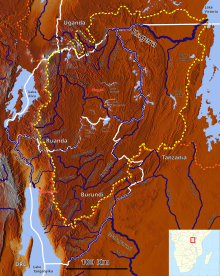
The Kagera River, also known as Akagera River, or Alexandra Nile, is an East African river, forming part of the upper headwaters of the Nile and carrying water from its most distant source. With a total length of 597 km (371 mi) from its source located in Lake Rweru in Rwanda.

Rusumo Falls is a waterfall located on the Kagera river on the border between Rwanda and Tanzania, part of the most distant headwaters of the river Nile. The falls are approximately 15 m (49 ft) high and 40 m (130 ft) wide and have formed on Precambrian schists and quartz–phyllites.
The five provinces of Rwanda are divided into 30 districts. Each district is in turn divided into sectors, which are in turn divided into cells, which are in turn divided into villages.

Huye is one of the eight districts (Akarere) that make up Rwanda's Southern Province. It has a total surface area of 581.6 square Kilometers. It has thirteen sectors and 77 cells with a total of 508 umudugudus (villages) in total. The district has a population of 381,900, with an average of 660 inhabitants per square kilometer. The largest city in the province is Butare.

Nyanza is a district (akarere) in Southern Province, Republic of Rwanda. Its capital is Nyanza town, which is also the provincial capital. Nyanza is a Bantu word meaning lake, which probably refers to the small body of water created by a dam to the west of Nyanza town and sometimes referred to by the local residents as “Ikiyaga” or lake. which probably refers to a large lake to the west of Nyanza city.

Gasabo is a district (akarere) in Kigali city, the capital of Rwanda. The headquarter of Gasabo is located in Remera Sector. The district also includes large areas of the city itself, including Kacyiru, Kimironko, Remera, Nyarutarama and Kimihurura.

Kicukiro District is one of the three Districts which constitute the City of Kigali and is situated in the South-East of the City of Kigali. Is a district (akarere) located in Kigali Province, Rwanda. Kicukiro is home to a thriving market, a number of NGOs(Non-Government Organizations) and the Bralirwa Brewery. In addition, it is the headquarters for the Friends Church in Rwanda. Kicukiro District is also home to two major memorial sites associated with the Rwandan genocide. These are the Rebero Genocide Memorial Site where 14,400 victims are buried, and the Nyanza Genocide Memorial Site where 5,000 victims were killed after Belgian soldiers who were serving in the United Nations peacekeeping forces abandoned them.
The Nyabarongo is a major river in Rwanda, part of the upper headwaters of the Nile. With a total length of 351 km (218 mi), it is the longest river entirely in Rwanda. It is extended 421 km (262 mi) in Lake Rweru including a 69 km (43 mi) upper course of Kagera River before joining into Ruvuvu River to form the Kagera River. The river begins its course at the confluence of the rivers Mbirurume and Mwogo in the South West of the country. These two rivers themselves begin in Nyungwe Forest, and are considered by some to be the most distant source of the Nile. From its start, Nyabarongo flows northward for 85 km, and forms the border between the Western and Southern Provinces. At the confluence with the river Mukungwa, the river changes course and flows eastward for 12 km, then to a more South Eastern course for the last 200 km. For the longest stretch of this course, the river serves as the boundary between the Northern and Southern Provinces, then between the City of Kigali and the Southern Province, and lastly between the City of Kigali and the Eastern Province.

The Rukarara River is a river in western Rwanda that is a tributary of the Mwogo River, in turn a tributary of the Nyabarongo River. It is the most distant headwater of the Nile.
The Rusumo Hydroelectric Power Station, also known as the Rusumo Power Station, is a hydropower plant under construction, with initial planned capacity installation of 80 megawatts (110,000 hp) when completed. The project will involve the construction of a dam, with run of river design. A more expensive 90 megawatts (120,000 hp) reservoir design was considered before being abandoned in favor of an 80 MW project with a smaller environmental impact and an estimated cost of US$300 million compared to US$400 million for the bigger project. The World Bank announced on 6 August 2013 that it had approved loans totaling US$340 million towards the US$468.60 million needed for the project. In November 2013, the African Development Bank approved a loan of US$113 million towards completion of the project.
Nyabarongo I Hydroelectric Power Station is a 28 megawatts (38,000 hp) hydroelectric power station in Rwanda.
The Koko River is a river in the Rutsiro District of western Rwanda that flows into Lake Kivu.

The Akanyaru River is the main tributary of the Nyabarongo River. It rises in the western highlands of Rwanda and Burundi, flows east and then north along the border between those countries before joining the Nyabarongo River. The lower stretches contain important but unprotected wetlands, which are under threat from human activity.
The Mbirurume is a river in western Rwanda that is a tributary of the Nyabarongo River.
Rusumo, is a town in Kirehe District in the Eastern Province of Rwanda.
Rusumo is a town in northwestern Tanzania, at the border with Rwanda. It sits across the Kagera River from Rusumo, Rwanda.
The Nyabarongo II Multipurpose Dam, is a multipurpose dam under construction across the Nyabarongo River in Rwanda. The dam will measure 48 metres (157 ft) high and 228 metres (748 ft) long, creating a reservoir with storage capacity of 846,000,000 cubic meters (8.46×10¹¹ L). The reservoir is also expected to provide irrigation water to an estimated 20,000 hectares (49,000 acres) of land, downstream of the dam site. In addition, the dam will host Nyabarongo II Hydroelectric Power Station, with installed generating capacity of 43.5 megawatts.