Nile Basin

Last updated
The Nile Basin Nile basin map.png
The Nile Basin

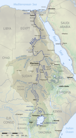
The Nile Basin is the part of Africa drained by the Nile River and its tributaries.

Besides being the second largest hydrographic basin in Africa, the Nile Basin is effectively the most notable drainage basin on the continent. It covers approximately 2,870,000 km2, [1] or about 10% of African territory, crossing arid regions and with a high population density. The Nile Basin Initiative (NBI) has been in existence since 1999, with the aim of strengthening cooperation in sharing its resources concerned. [2]

The drainage area of the basin covers Burundi, Chad, the Democratic Republic of the Congo, Egypt, Eritrea, Ethiopia, Kenya, Rwanda, South Sudan, the Sudan, Tanzania, and Uganda. The Basin is the main supplier of fresh water, electricity, and fish for the local residents of these countries, supporting about 270 million inhabitants, or 20% of the African population. The basin rises in the highlands and flows in extremely arid regions, in particular the Sahara Desert. [3]

Its main navigable course is through the Nile River, being the mouth section in the Mediterranean Sea (more precisely after the Nile Delta) until it surrounds the city of Aswan, in southern Egypt. There are also navigable courses at the Aswan Dam. In the middle Nile, after the dam, due to the presence of waterfalls north of Khartoum (Sudan), the river is navigable in just three stretches. The first is from the Egypt–Sudan border to the southern tip of Lake Nasser. The second is the section between the third and fourth cataracts. The third and most important stretch extends from Khartoum, in the south, to Juba (South Sudan). [4]

The main water supplier for the basin is Lake Victoria, located in the Great Rift Valley. [4] About 238 million people live within the Nile basin, 172 million of those inhabit rural localities. [5]

In the southwestern part of the basin in South Sudan near the watershed with Congo Basin relief is made up a single large pediplain. [6] Heights that rise above this pediplain contain laterite soils, sometimes with pisolites or ferricrete, and are remnants of an older surface. [6] Some of the summits corresponding to the said old surface were formed by relief inversion of valleys. [6]

Related Research Articles

<span class="mw-page-title-main">Geography of Africa</span>

Africa is a continent comprising 63 political territories, representing the largest of the great southward projections from the main mass of Earth's surface. Within its regular outline, it comprises an area of 30,368,609 km2 (11,725,385 sq mi), excluding adjacent islands. Its highest mountain is Kilimanjaro; its largest lake is Lake Victoria.

<span class="mw-page-title-main">Geography of Egypt</span> Geographical features of Egypt

The geography of Egypt relates to two regions: North Africa and West Asia.

<span class="mw-page-title-main">Nile</span> Major river in northeastern Africa

The Nile is a major north-flowing river in northeastern Africa. It flows into the Mediterranean Sea. The Nile is the longest river in Africa and has historically been considered the longest river in the world, though this has been contested by research suggesting that the Amazon River is slightly longer. Of the world's major rivers, the Nile is one of the smallest, as measured by annual flow in cubic metres of water. About 6,650 km (4,130 mi) long, its drainage basin covers eleven countries: the Democratic Republic of the Congo, Tanzania, Burundi, Rwanda, Uganda, Kenya, Ethiopia, Eritrea, South Sudan, Sudan, and Egypt. In particular, the Nile is the primary water source of Egypt, Sudan and South Sudan. Additionally, the Nile is an important economic river, supporting agriculture and fishing.

<span class="mw-page-title-main">Geography of Sudan</span> Geographical features of Sudan

Sudan is located in Northeast Africa. It is bordered by Egypt to the north, the Red Sea to the northeast, Eritrea and Ethiopia to the east, South Sudan to the south, the Central African Republic to the southwest, Chad to the west and Libya to the northwest. Sudan is the third largest country in Africa, after Algeria and the Democratic Republic of the Congo. It had been the largest country on the continent until the 2011 independence of South Sudan.

<span class="mw-page-title-main">Transport in Sudan</span> Extensive railroad system

Transport in Sudan during the early 1990s included an extensive railroad system that served the more important populated areas except in the far south, a meager road network, a natural inland waterway—the Nile River and its tributaries—and a national airline that provided both international and domestic service. Complementing this infrastructure was Port Sudan, a major deep-water port on the Red Sea, and a small but modern national merchant marine. Additionally, a pipeline transporting petroleum products extended from the port to Khartoum.

<span class="mw-page-title-main">Aswan Dam</span> Dam in Aswan, Egypt

The Aswan Dam, or more specifically since the 1980s, the Aswan High Dam, is one of the world's largest embankment dams, which was built across the Nile in Aswan, Egypt, between 1960 and 1970. When it was completed, it was the tallest earthen dam in the world, eclipsing the United States' Chatuge Dam. Its significance largely upstaged the previous Aswan Low Dam initially completed in 1902 downstream. Based on the success of the Low Dam, then at its maximum utilization, construction of the High Dam became a key objective of the new regime the Free Officers movement of 1952; with its ability to better control flooding, provide increased water storage for irrigation and generate hydroelectricity, the dam was seen as pivotal to Egypt's planned industrialization. Like the earlier implementation, the High Dam has had a significant effect on the economy and culture of Egypt.

<span class="mw-page-title-main">White Nile</span> River originating in Burundi or Rwanda

The White Nile is a river in Africa, one of the two main tributaries of the Nile, the other being the Blue Nile. The name comes from the clay sediment carried in the water that changes the water to a pale color.

<span class="mw-page-title-main">Atbarah River</span> River flowing between Ethiopia and Sudan

The Atbarah River, also referred to as the Red Nile and / or Black Nile, is a river in northeast Africa. It rises in northwest Ethiopia, approximately 50 km north of Lake Tana and 30 km west of Gondar. It then flows about 805 km (500 mi) to the Nile in north-central Sudan, joining it at the city of Atbarah. The river's tributary, the Tekezé (Setit) River, is perhaps the true upper course of the Atbarah, as the Tekezé follows the longer course prior to the confluence of the two rivers in northeastern Sudan. The Atbarah is the last tributary of the Nile before it reaches the Mediterranean.

<span class="mw-page-title-main">Cape to Cairo Railway</span> Proposed but never completed railway connecting British colonies in eastern Africa

The Cape to Cairo Railway was an unfinished project to create a railway line crossing Africa from south to north. It would have been the largest and most important railway of that continent. It was planned as a link between Cape Town in South Africa and Port Said in Egypt.

<span class="mw-page-title-main">Toshka Lakes</span> Lakes in Egypt

Toshka Lakes is the name given to recently formed endorheic lakes in the Sahara Desert of Egypt. Their presence is caused by periodic overflow from Lake Nasser.

<span class="mw-page-title-main">Merowe Dam</span> Dam in Merowe, Sudan

The Merowe Dam, also known as Merowe High Dam, Merowe Multi-Purpose Hydro Project or Hamdab Dam, is a large dam near Merowe Town in northern Sudan, about 350 kilometres (220 mi) north of the capital Khartoum. Its dimensions make it the largest contemporary hydropower project in Africa. It is situated on the river Nile, close to and inundating the 4th Cataract where the river divides into multiple smaller branches with large islands in between. Merowe is a city about 40 kilometres (25 mi) downstream from the construction site at Hamdab. The main purpose for building the dam was the generation of electricity.

<span class="mw-page-title-main">Cataracts of the Nile</span> Series of six whitewater rapids

The Cataracts of the Nile are shallow lengths of the Nile river, between Khartoum and Aswan, where the surface of the water is broken by many small boulders and stones jutting out of the river bed, as well as many rocky islets. In some places, these stretches are punctuated by whitewater, while at others the water flow is smoother but still shallow.

<span class="mw-page-title-main">Butana</span> Region between the Atbara and the Nile in the Sudan

The Butana, historically called the Island of Meroë, is the region between the Atbara and the Nile in the Sudan. South of Khartoum it is bordered by the Blue Nile and in the east by Lake Tana in Ethiopia. It should not be confused with the Gezira, the region west of the Blue Nile and east of the White Nile.

<span class="mw-page-title-main">Water politics in the Nile Basin</span> Political interactions between nations based on the path of the Nile through international borders

As a body of water that crosses numerous international political borders, the Nile river is subject to multiple political interactions. Traditionally it is seen as the world's longest river flowing 6,700 kilometres (4,200 mi) through ten countries in northeastern Africa – Rwanda, Burundi, Democratic Republic of the Congo (DRC), Tanzania, Kenya, Uganda, Ethiopia, South Sudan, Sudan and Egypt with varying climates.

The Nile Basin Initiative (NBI) is a partnership among the Nile riparian states that “seeks to develop the river in a cooperative manner, share substantial socioeconomic benefits, and promote regional peace and security”. The NBI began with a dialogue among the riparian states that resulted in a shared vision objective “to achieve sustainable socioeconomic development through the equitable utilization of, and benefit from, the common Nile Basin water resources." It was formally launched in February 1999 by the water ministers of nine countries that share the river: Egypt, Sudan, Ethiopia, Uganda, Kenya, Tanzania, Burundi, Rwanda, the Democratic Republic of Congo (DRC), as well as Eritrea as an observer. From its beginning the Nile Basin Initiative has been supported by the World Bank and by other external partners. The World Bank has a mandate to support the work of the NBI, as lead development partner and as administrator of the multi-donor Nile Basin Trust Fund. One of the partners is the "Nile Basin Discourse", which describes itself as "a civil society network of organisations seeking to achieve positive influence over the development of projects and programmes under the Nile Basin Initiative".

Water resources management in modern Egypt, is a complex process that involves multiple stakeholders who use water for irrigation, municipal and industrial water supply, hydropower generation and navigation. In addition, the waters of the Nile support aquatic ecosystems that are threatened by abstraction and pollution. Egypt also has substantial fossil groundwater resources in the Western Desert.

<span class="mw-page-title-main">Environmental issues in Egypt</span>

Egypt's environmental problems include, but are not limited to, water scarcity, air pollution, damage to historic monuments, animal welfare issues and deficiencies in its waste management system.

<span class="mw-page-title-main">Geography of South Sudan</span>

The geography of South Sudan describes the physical features of South Sudan, a country in East Africa. South Sudan is a landlocked country and borders – clockwise – Sudan from the north, Ethiopia from the east, Kenya, Uganda and the Democratic Republic of the Congo from the south and the Central African Republic from the west.

Water conflict in the Middle East and North Africa (MENA) primarily deals with three major river basins: the Jordan River Basin, the Tigris-Euphrates River Basin, and the Nile River Basin. The MENA region covers roughly 11.1 million square km. There are three major deserts in the MENA region:

<span class="mw-page-title-main">Congo–Nile Divide</span> Continental divide in Africa

The Congo–Nile Divide or the Nile–Congo Watershed is the continental divide that separates the drainage basins of the Congo and Nile rivers. It is about 2,000 kilometres (1,200 mi) long.

References

  1. The Nile basin. in.: Irrigation potential in Africa: A basin approach. Roma: Organização das Nações Unidas para Alimentação e Agricultura. 1997
  2. NBI Strategy. NBI. 2020
  3. The Nile River Basin - an introduction. Waternet. 2017.
  4. 1 2 Nile river basin: Dams and reservoirs. Encypaedia Bittanica. 2020.
  5. Kimenyi, Mwangi; Mbaku, John (2015-02-12). Governing the Nile River Basin: The Search for a New Legal Regime. Brookings Institution Press. pp. 10–11. ISBN   978-0-8157-2656-2.
  6. 1 2 3 Fölster, Horst (1964). "Morphogenese der südsudanischen Pediplane". Zeitschrift für Geomorphologie (in German). 8 (4): 393–423.