Mbirurume River

Last updated
Mbirurume River
Country Rwanda
Physical characteristics
River mouth 2°12′18″S29°33′36″E / 2.204875°S 29.559917°E / -2.204875; 29.559917 Coordinates: 2°12′18″S29°33′36″E / 2.204875°S 29.559917°E / -2.204875; 29.559917
Basin features
River system Nyabarongo River

The Mbirurume (also called Bilirume, Biruruma, Birurume, Bitirume) is a river in western Rwanda that is a tributary of the Nyabarongo River.

Rwanda Country in Africa

Rwanda, officially the Republic of Rwanda, is a country in Central and East Africa and one of the smallest countries on the African mainland. Located a few degrees south of the Equator, Rwanda is bordered by Uganda, Tanzania, Burundi, and the Democratic Republic of the Congo. Rwanda is in the African Great Lakes region and is highly elevated; its geography is dominated by mountains in the west and savanna to the east, with numerous lakes throughout the country. The climate is temperate to subtropical, with two rainy seasons and two dry seasons each year.

Nyabarongo River river in Rwanda

The Nyabarongo is a major river in Rwanda, part of the upper headwaters of the Nile. At 297 km, it is the longest river entirely in Rwanda. The river begins its course at the confluence of the rivers Mbirurume and Mwogo in the South West of the country. These two rivers themselves begin in Nyungwe Forest, and are considered by some to be the most distant source of the Nile. From its start, Nyabarongo flows northward for 85 km, and forms the border between the Western and Southern Provinces. At the confluence with the river Mukungwa, the river changes course and flows eastward for 12 km, then to a more South Eastern course for the last 200 km. For the longest stretch of this course, the river serves as the boundary between the Northern and Southern Provinces, then between the City of Kigali and the Southern Province, and lastly between the City of Kigali and the Eastern Province. The river then before enters the Eastern Province and ends its course close to the border with Burundi. The Nyabarongo River empties both in Lake Rweru and Akagera river in a small but complicated Delta. The Akagera river outflows from Lake Rweru, a mere 1 km from the Nyabarongo delta. Almost all the branches of the Nyabarongo delta empty in the lake, however, one branch of the delta empties directly in the just formed Akagera river. The Akagera River eventually flows into Lake Victoria and forms the Nile.

The Mbirurume rises in forested country in southern Rwanda to the east of the Congo-Nile Divide. [1] It originates in the extreme north of the Nyungwe National Park, in the Nyamagabe District. It flows in a northeast direction, entering Karongi District and passes Mukungu to the west, then runs in a northeast direction along the border between Nyamagabe and Karongi districts. It then turns southeast shortly before meeting the Mwogo River from the left. [2] [3] The combined rivers form the Nyabarongo River, which flows northward along the eastern slopes of the Nile-Congo divide. [1]

Congo-Nile Divide (Rwanda-Burundi)

The Congo-Nile Divide region of Rwanda and Burundi is a mountainous area in the southern section of the Congo-Nile Divide, to the east of the Albertine Rift. The region includes the Nyungwe and Kibira national parks. The Bugoyi people live in the region.

Nyamagabe District District in Rwanda

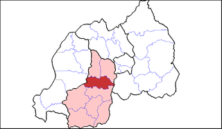
Nyamagabe is a district (akarere) in Southern Province, Rwanda. Its capital is Gasaka.

Karongi District District in Rwanda

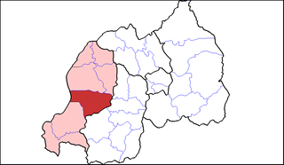
Karongi is a district (akarere) in Western Province, Rwanda. Its capital is Rubengera, but the district also contains Kibuye, Rwanda, the provincial capital and a major Rwandan lakeside resort.

Related Research Articles

Kigali Place in Kigali Province, Rwanda

Kigali is the capital and largest city of Rwanda. It is near the nation's geographic centre. The city has been Rwanda's economic, cultural, and transport hub since it became capital at independence in 1962. The city hosts the main residence and offices of the President of Rwanda and government ministries. The city is within the province of Kigali City, which was enlarged in January 2006, as part of local government reorganisation in the country. Kigali's city limits cover the whole province; it is consolidated. The city's urban area covers about 70% of the municipal boundaries.

Geography of Rwanda

Rwanda is located in central Africa, to the east of the Democratic Republic of the Congo, at the co-ordinates 2°00′S30°0′E.

White Nile river in Africa and tributary of the Nile River

The White Nile is a river in Africa, one of the two main tributaries of the Nile; the other is the Blue Nile. The name comes from colouring due to clay carried in the water.

Albertine Rift

The Albertine Rift is the western branch of the East African Rift, covering parts of Uganda, the Democratic Republic of the Congo (DRC), Rwanda, Burundi and Tanzania. It extends from the northern end of Lake Albert to the southern end of Lake Tanganyika. The geographical term includes the valley and the surrounding mountains.

Districts of Rwanda

The five provinces of Rwanda are divided into 30 districts. Each district is in turn divided into sectors, which are in turn divided into cells, which are in turn divided into villages.

Ngounié River river in Gabon

The Ngounié River is a river flowing through southwest-central Gabon. It is the last and second most important tributary of the Ogooué River, the first being the Ivindo River. It initially flows down from the Chaillu Mountains, along the border with Congo, and then turns northwest, flowing through the towns of Fougamou, Sindara and Mouila before flowing into the Ogooué.

Ruhango District District in Rwanda

Ruhango is a district (akarere) in Southern Province, Rwanda. Its capital is Ruhango town, a large settlement on the road between Gitarama and Butare.

Wildlife of Rwanda

The wildlife of Rwanda comprising its flora and fauna, in prehistoric times, consisted of montane forest in one third the territory of present-day Rwanda. However, natural vegetation is now mostly restricted to the three National Parks and four small forest reserves, with terraced agriculture dominating the rest of the country.

Rutsiro District District in Rwanda

Rutsiro is a district (akarere) in Western Province, Rwanda. Its headquarter is located in Gihango sector.

Lake Muhazi

Lake Muhazi is a long thin shallow lake in the east of Rwanda. The bulk of the lake lies in the Eastern Province, with the western end forming the border between the Northern and Kigali Provinces. It is a flooded valley lake, lying predominantly in an east to west direction, but with numerous offshoots in a north to south direction, formerly the location of tributaries. The lake has a concrete dam at the western end, constructed in 1999 to replace an earth dam which had existed since time immemorial. The lake empties into the Nyabugogo River, which flows southwards to Kigali where it meets the Nyabarongo River, part of the upper Nile.

Rukarara River river in Rwanda

The Rukarara River is a river in western Rwanda that is a tributary of the Mwogo River, in turn a tributary of the Nyabarongo River. It is the most distant headwater of the Nile.

Lake Mugesera is a lake in the Eastern Province, Rwanda.

The Rubyiro River is a river in southwestern Rwanda that is a left-hand tributary of the Ruzizi River. It joins the Ruzizi, which forms the boundary between Rwanda and the Democratic Republic of the Congo, about 2 kilometres (1.2 mi) above the point where the Ruhwa River, which forms the boundary between Rwanda and Burundi, enters the Ruzizi.

The Ruhwa River is a river in southwestern Rwanda that is a left-hand tributary of the Ruzizi River. It joins the Ruzizi, which forms the boundary between Rwanda and the Democratic Republic of the Congo, about 2 kilometres (1.2 mi) below the point where the Rubyiro River enters the Ruzizi. The Ruhwa forms the boundary between the western regions of Rwanda and Burundi.

The Koko River is a river in the Rutsiro District of western Rwanda that flows into Lake Kivu.

The Akanyaru River is the main tributary of the Nyabarongo River. It rises in the western highlands of Rwanda and Burundi, flows east and then north along the border between those countries before joining the Nyabarongo River. The lower stretches contain important but unprotected wetlands, which are under threat from human activity.

The Mwogo River is a river in western Rwanda that is a tributary of the Nyabarongo River.

References

Citations

  1. 1 2 Hughes, Hughes & Bernacsek 1992, p. 201.
  2. Nyamagabe Administrative Map.
  3. Karongi Administrative Map.

Sources

International Standard Book Number Unique numeric book identifier

The International Standard Book Number (ISBN) is a numeric commercial book identifier which is intended to be unique. Publishers purchase ISBNs from an affiliate of the International ISBN Agency.