Huye District

Last updated
Huye District
National Museum of Rwanda - Butare - Flickr - Dave Proffer (4).jpg
The Ethnographic Museum in Butare
HuyeDist.png
Shown within Southern Province and Rwanda
Country Rwanda
Prefecture Southern
Capital Butare
Area
   District 581.6 km2 (224.6 sq mi)
Population
 (2022 census) [1]
   District 381,900
  Density660/km2 (1,700/sq mi)
   Urban
79,744
   Rural
302,156
Arboretum forest, 200 hectares of forest planted by the Belgians in 1934 ArboretumForest ,200 hectares forest planted located in Uni Rwanda HuyeDistrict RwandaSouth Started by the Belgians in 1934.png
Arboretum forest, 200 hectares of forest planted by the Belgians in 1934

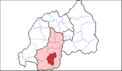
Huye is one of the eight districts (Akarere) that make up Rwanda's Southern Province. It has a total surface area of 581.6 square Kilometers. It has thirteen sectors and 77 cells with a total of 508 umudugudus (villages) in total. [2] The district has a population of 381,900, with an average of 660 inhabitants per square kilometer.[ citation needed ] The largest city in the province is Butare.

Contents

Geography and education

Huye borders with Nyanza district in the North, Gisagara in the east and south, Nyaruguru in the south west and Nyamagabe in the north west. The hilly landscape protrudes from east to west but develops into a steep hilly and mountainous area as one moves towards the west and north west. The western part of the district has tall undulating mountains, including the famous Huye mountain. The district has rainfall a distribution pattern of 1.200 mm and an average climate of 19 °C.[ citation needed ]

Huye was previously home to the National University of Rwanda, the oldest university in the country,[ citation needed ] but in 2013 it was merged with other universities in Rwanda to form the University of Rwanda.

The Ethnographic Museum which is home to Rwanda's cultural and historic heritage is also located in the district, also located in Butare. The museum houses some of the remains of last known Rwandan kings surrounded by some of the most ancient tools and traditional hardware.

Sectors

Huye district is divided into 14 sectors (imirenge): Gishamvu, Karama, Kigoma, Kinazi, Maraba, Mbazi, Mukura, Ngoma, Ruhashya, Huye, Rusatira, Rwaniro, Simbi and Tumba.[ citation needed ]

Related Research Articles

<span class="mw-page-title-main">Butare Province</span>

Butare was a province (prefecture) of Rwanda prior to its dissolution in January 2006. Butare city was the second largest city in Rwanda and one of the nation's former twelve provinces. It is located in south-central region of the country and borders Burundi to the south. It had a population of 77.449 as of January 2006.

<span class="mw-page-title-main">Phú Yên province</span> Province of Vietnam

Phú Yên is a central coastal province in the South Central Coast region, the Central of Vietnam. It borders Bình Định to the north, Khánh Hòa to the south, Gia Lai to the northwest, Đắk Lắk to the southwest and the East Sea to the east.

<span class="mw-page-title-main">Butare</span> Place in Southern Province, Rwanda

Butare, also known as Huye and formerly known as Astrida, is a city with a population of 75,000 in the Southern Province of Rwanda and the capital of Huye district. It is the fifth largest town in Rwanda by population.

<span class="mw-page-title-main">Southern Province, Rwanda</span> Province of Rwanda

Southern Province is one of Rwanda's five provinces. It was created in early January 2006 as part of a government decentralization program that re-organized the country's local government structures.

<span class="mw-page-title-main">Districts of Rwanda</span>

The five provinces of Rwanda are divided into 30 districts. Each district is in turn divided into sectors, which are in turn divided into cells, which are in turn divided into villages.

<span class="mw-page-title-main">Maraba coffee</span> Brewed beverage

Maraba coffee is grown in the Maraba area of southern Rwanda. Maraba's coffee plants are the Bourbon variety of the Coffea arabica species and are grown on fertile volcanic soils on high-altitude hills. The fruit is handpicked, mostly during the rainy season between March and May, and brought to a washing station in Maraba, where the coffee beans are extracted and dried. At several stages, the beans are sorted according to quality. The farmers receive credits based on the amount and quality of the beans they provide.

<span class="mw-page-title-main">Mount Huye</span>

Mount Huye is a mountain located near to the city of Butare in southern Rwanda. It is connected by a ridge to Nyungwe Forest to the west, and is on the outer edges of the Albertine Rift, the western branch of the East African Rift. The mountain is an important source of mineral water, supplying both the Huye bottled water brand sold throughout Rwanda and the nearby Maraba fair trade coffee plant, whose washing station receives Huye water via a pipeline built using ACDI/VOCA funding in 2002.

Huye may refer to:

<span class="mw-page-title-main">Maraba, Rwanda</span>

Maraba is a region in southern Rwanda. It used to be a district in the Butare Province before a government decentralization programme that re-organized the country's administrative divisions in 2006. It is now a sector of the Huye District in the Southern Province. The closest major city is Butare.

<span class="mw-page-title-main">Nyagatare District</span> District in Eastern Province, Rwanda

Nyagatare is the largest and second most populous district (akarere) in Rwanda. Located in Eastern Province, Rwanda, it occupies the northeastern extremity of Rwanda. Its capital is Nyagatare City, the former capital of the now defunct Umutara province. Nyagatare District borders Uganda in the North, Tanzania in the East, Gatsibo District of the in the South, and Gicumbi District of the Northern Province in the West. Nyagatare has an area of 1741 km2, what makes it the largest district in Rwanda. With a population of 466,944 in 2012, and 653,861 in 2023, Nyagatare is the second most populated district of Rwanda only after Gasabo District of Kigali City with 879,505 inhabitants. This is a 156% increase from 2002 when the population was only 255,104. This sharp rise in the population is mainly due to the major movement of the population from other parts of the country in search of land.

<span class="mw-page-title-main">Muhanga District</span> District in Rwanda

Muhanga is a district (akarere) in Rwanda. It is found in southern province and its administrative centre is located in the city of Muhanga.

<span class="mw-page-title-main">Nyanza District</span> District in Rwanda

Nyanza is a district (akarere) in Southern Province, Republic of Rwanda. Its capital is Nyanza town, which is also the provincial capital. Nyanza is a Bantu word meaning lake, which probably refers to the small body of water created by a dam to the west of Nyanza town and sometimes referred to by the local residents as “Ikiyaga” or lake. which probably refers to a large lake to the west of Nyanza city.

<span class="mw-page-title-main">Nyaruguru District</span> District in Rwanda

Nyaruguru is a district (akarere) in Southern Province, Rwanda. Its capital is Kibeho, a pilgrimage site of the Catholic Church.

<span class="mw-page-title-main">Ruhango District</span> District in Rwanda

Ruhango is a district (akarere) in Southern Province, Rwanda. Its capital is Ruhango town, a large settlement on the road between Gitarama and Butare.

<span class="mw-page-title-main">Rubavu District</span> District in Rwanda

Rubavu District is one of the seven districts (akarere) in Western Province, Rwanda. Its capital is Gisenyi, a large beach resort and border city. It has a total surface area of 388.4 Km2. The Rubavu Urban area, which includes Gisenyi, Rugerero and other nearby localities, had a 2012 population of 149,209, the second most populous urban area in Rwanda.

<span class="mw-page-title-main">Nyabihu District</span> District in Rwanda

Nyabihu is a district (akarere) in Western Province, Rwanda. Its capital is Mukamira. Nyabihu district is divided into 12 sectors (imirenge): Bigogwe, Jenda, Jomba, Kabatwa, Karago, Kintobo, Mukamira, Muringa, Rambura, Rugera, Rurembo and Shyira.These sectors are themselves separated in 73 cells and 474 villages also called “imidugudu".

<span class="mw-page-title-main">Dongcheng Subdistrict, Dongguan</span> Subdistrict in Guangdong, Peoples Republic of China

Dongcheng Subdistrict is one of the four subdistricts of Dongguan, Guangdong Province, China. The subdistrict has an area of 105.9 square kilometers, and, as of 2019, has a permanent population of around 500,000, and a registered population of around 99,500. Dongcheng Subdistrict's GDP as of 2019 is ¥58.656 billion.

<span class="mw-page-title-main">Gikongoro Province</span> Former province of Rwanda

Gikongoro Province was one of the former twelve provinces (intara) of Rwanda and is situated in the southwest of the country. The former province had an area of some 2,146 square kilometers. Its population was estimated at 466,451 (1990) and 511,776 (2002) prior to its dissolution in January 2006, with an annual growth rate of .810% between the years of 1990 and 2002. It included 13 "communes" and 125 sectors.

Butare Airport is an airport in Butare, Rwanda.

The Saint Charles Borromeo Major Seminary of Nyakibanda is a Roman Catholic seminary near to Butare, in the Gishamvu sector of the Huye District in Southern Province of Rwanda, below the mountain chain called "Ibisi bya Nyakibanda". It is about 12 kilometres (7.5 mi) from Butare.

References

  1. Citypopulation.de Population of Huye District
  2. Rwanda Statistical YearBook (2019 ed.). National Institute of Statistics of Rwanda (NISR). 2019. pp. 18 (xviii). ISBN   978-99977-43-44-2.

2°31′S29°42′E / 2.517°S 29.700°E / -2.517; 29.700