Rubavu District

Last updated
Rubavu District
RubavuDist.png
Shown within Western Province and Rwanda
Country Rwanda
Province Western
Capital Gisenyi
Area
   District 388.4 km2 (150.0 sq mi)
Population
 (2022 census) [1]
   District 546,683
  Density1,400/km2 (3,600/sq mi)
   Urban
294,448
   Rural
252,235

Rubavu District is one of the seven districts (akarere) in Western Province, Rwanda, with a total surface area of 388.4 km2. Its capital is Gisenyi, a large beach resort and border city. The Rubavu Urban area, which includes Gisenyi, Rugerero and other nearby localities, had a 2012 population of 149,209, the second most populous urban area in Rwanda.

Contents

Geography

The district lies on the shores of Lake Kivu, around the city of Gisenyi, and just across the border from the Congolese city of Goma.

It is bordered in the east by Nyabihu District, west and north by the Democratic Republic of Congo and south by Rutsiro district and is 154.7 km from city of Kigali the capital of Rwanda which is 2 hours and 53 minutes drive. Its geographic location and related features such as lake kivu helps the district to be a business and tourism hub (especially through cross border trade with DRC). The District of Rubavu is composed of 12 administrative sectors, 80 Cells and 525 Villages (Imidugudu). Geography of the District Rainfall in Rubavu District varies between 1200 mm and 1500 mm per year. The Land of Northwest part of the District has a very rich soil, but shallow, volcanic ash and lava decomposed, while land in the south east has deep soils but poor, often acidic, sandy clay and leached by high erosion, It is also close to Mount Nyiragongo, an active volcano. On 2 May 2021, a new eruption started. [2]

Rubavu District has a very strategic location as it is one hour drive away from Volcanoes National Park and has a good stopover to or from Nyungwe National Park, and a suitable relaxation point from the hectic Gorilla trekking or Chimpanzee trekking respectively [3]

An aerial view of Paradis Malahide island in Lake Kivu with the area of 2,700 km An aerial of Paradis Malahide island in Lake Kivu with the area of 2,700 km2. Emmanuel Kwizera.jpg
An aerial view of Paradis Malahide island in Lake Kivu with the area of 2,700 km

Demography

In 2012, The fourth Rwanda Population and Housing Census (PHC4), enumerated 403,662 residents in Rubavu District on a density of 1039 Inhabitants/Km2 , where 51.7 % of the total population are females and 48.3 % are male. Total population in urban areas is 149,209 which makes 37% of the total district's population whereas 254,453 (63%) reside in rural areas. The district's population represents 3.8% of the total country's population and 16.3 % of the Western Province population (2,471,239 inhabitants). The average house-hold size is 5.2 against 4.8 at national level, the population aged between 0-14 years old represented 43.8% and the population aged between 15 and 49 years old represented 47.8% while those above 50 years old represented 8.1%. [4]

Tourism

Tourism has been highlighted as the potential main economic sector for Rubavu District. In the last few years there has been a growth in the number of hotels and resorts in Rubavu. Rubavu is mostly a weekend destination for Rwandan's wanting to relax by Lake Kivu for a weekend, but also for international visitors on a safari to Rwanda. [5] Rubavu is also the start of the Congo Nile Trail.

Beach Bars

Located a short distance away across the bridge over Sebeya River from Rubavu Public Beach and the city center is a series of beach bars on the shores of Lake Kivu. This place is rather lively on weekends and attracts visitors from Democratic Republic of Congo and Kigali. The series of beach bars offer live music food and drinks on the lake's edge [5]

Mount Rubavu climbing

Gisenyi city is located at the heel of Mount Rubavu. A climb at the top of the mountain rewards you with exceptional views of Gisenyi town and the entire Lake Kivu as well as the neighboring city of Goma. Mount Rubavu also has an interesting history as it had the bases of Germans during their battles with Belgians in the First World War. There is also rock climbing sport at the mountain.

Pfunda tea estate

Tea plantation Malabar Tea Plantation Bandung South.jpg
Tea plantation

Is on the main estate where tea growing takes place producing some of the world's best teas, It lies between Virunga Volcano and the rich volcanic soil nine kilometers from Rubavu town, farmers in this plantation are welcoming and willing to take on a tour in the plantation showing how to pick a tea leaves and how they are processed to tea. [6]

Gisenyi public beach

This beach is created by a strip of yellow sand, grey and green water.

Rubona peninsula

It is found from six kilometers from Rubavu town, it is on the Lac Kivu shores with hills steeply from the lake's foreshores and patches of green garden. It has sandy beaches suitable for swimming. Is a site of many boats and men carrying out fishing.

Kayaking on Lake Kivu

This is another place on the waters which is very safe, the lake harbors no hippopotamus or crocodiles.[ citation needed ]

Palm oil plantation Oilpalm malaysia.jpg
Palm oil plantation

Congo Nile trail.

Congo Nile is a 227 km trail along lake Kivu forming Kivu belt as it extends from Rubavu, continues through Rutsiro, then Karongi, up to Nyamasheke and ends at Rusizi District. It offers a tour on foot or on bike, it depends on tourists, with magnificent views of Lake Kivu. [7]

Palm oil plantation

In this district there are many palm oil plantations which also attract tourists.

Hotels and accommodation

Rubavu District has many different hotels, lodges: Celena Hotel, Gorilla Lake Kivu Hotel, Hakuna Matata lodge, Kivu Peace View Hotel, Bora Smart Guest House, The Palm Beach Resort and others.

Sectors

Rubavu district is divided into 12 sectors (imirenge): Bugeshi, Busasamana, Cyanzarwe, Gisenyi, Kanama, Kanzenze, Mudende, Nyakiliba, Nyamyumba, Nyundo, Rubavu and Rugerero. [8]

See also

Related Research Articles

<span class="mw-page-title-main">Transport in Rwanda</span>

The transport system in Rwanda centres primarily around the road network. Paved roads lie between the capital, Kigali, and most other major cities and towns in the country. Rwanda is also linked by road with other countries in the African Great Lakes, via which the majority of the country's imports and exports are made.

<span class="mw-page-title-main">North Kivu</span> Province of the Democratic Republic of the Congo

North Kivu is a province bordering Lake Kivu in the eastern Democratic Republic of the Congo. Its capital is Goma. The 2020 population was estimated to be 8,147,400.

<span class="mw-page-title-main">Mount Nyiragongo</span> Active volcano in the Democratic Republic of the Congo

Mount Nyiragongo is an active stratovolcano with an elevation of 3,470 m (11,385 ft) in the Virunga Mountains associated with the Albertine Rift. It is located inside Virunga National Park, in the Democratic Republic of the Congo, about 12 km (7.5 mi) north of the town of Goma and Lake Kivu and just west of the border with Rwanda. The main crater is about two kilometres (1 mi) wide and usually contains a lava lake. The crater presently has two distinct cooled lava benches within the crater walls – one at about 3,175 m (10,417 ft) and a lower one at about 2,975 m (9,760 ft).

<span class="mw-page-title-main">Goma</span> Provincial capital and city in North Kivu, DR Congo

Goma is the capital and largest city of the North Kivu Province in the eastern region of the Democratic Republic of the Congo (DRC). It is located on the northern shore of Lake Kivu, next to the Rwandan city of Gisenyi. It shares its borders with Bukumu Chiefdom to the north, the Republic of Rwanda to the east, Masisi Territory to the west, and is flanked by Lake Kivu to the south. The city lies in the Albertine Rift, the western branch of the East African Rift System, and lies only 13–18 km (8.1–11.2 mi) south of the active Nyiragongo Volcano. With an approximate area of approximately 75.72 square kilometers, the city has an estimated population of nearly 2 million people according to the 2022 census, while the 1984 estimate placed the number at 80,000.

<span class="mw-page-title-main">Kibuye, Rwanda</span> Place in Western Province, Rwanda

Kibuye is a city in Karongi District, and the headquarters of the Western Province in Rwanda.

<span class="mw-page-title-main">Gisenyi</span> City in Western Province, Rwanda

Gisenyi, historically rendered as Kisenyi, is the second largest city in Rwanda, located in the Rubavu district in Rwanda's Western Province. Gisenyi is contiguous with Goma, the city across the border in the Democratic Republic of the Congo.

<span class="mw-page-title-main">Albertine Rift montane forests</span> Ecoregion in east-central Africa

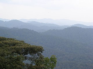
The Albertine Rift montane forests is a tropical moist broadleaf forest ecoregion in east-central Africa. The ecoregion covers the mountains of the northern Albertine Rift, and is home to distinct Afromontane forests with high biodiversity.

Tourism in Rwanda is the largest source of foreign exchange earnings in Rwanda and was projected to grow at a rate of 25% every year from 2013-2018. The sector is the biggest contributor to the national export strategy. Total revenues generated from the sector in 2014 alone were USD 305 million. The sector has also attracted direct foreign investments with major international hotel brands setting up shop in the country including Marriot Hotels & Resorts, Radisson Blu, Park Inn by Radisson, Sheraton Hotels and Resorts, Protea Hotels by Marriott, Golden Tulip Hotels, and Zinc. With its new world-class convention center, Rwanda is set to become a regional and international conference hub owing to ever-improving conference facilities, an excellent and expanding transportation network, and straightforward immigration procedures such as the ability for online visa applications, visa-free for all Africans, and a one-tourist visa policy for the EAC.

<span class="mw-page-title-main">Muhanga District</span> District in Rwanda

Muhanga is a district (akarere) in Rwanda. It is found in southern province and its administrative centre is located in the city of Muhanga.

<span class="mw-page-title-main">Karongi District</span> District in Rwanda

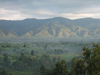
Karongi is a district (akarere) in Western Province, Rwanda. The district's capital is Rubengera. However, it comprises Kibuye, provincial capital and a major Rwandan lakeside resort. It is one of the districts with the lowest population density of 380 inhabitants per square kilometre (980/sq mi) as of the 2022 census.

<span class="mw-page-title-main">Rutsiro District</span> District in Rwanda

Rutsiro is a district (akarere) in Western Province, Rwanda. Its headquarter is located in Gihango sector.

<span class="mw-page-title-main">Masisi Territory</span> Territory in North Kivu, DR Congo

Masisi Territory is a territory which is located within the North Kivu Province of the Democratic Republic of the Congo. Its political headquarters are located in the town of Masisi.

These are some of the articles related to Rwanda on the English Wikipedia pages:

Gisenyi Airport is an airport in Rwanda. It has IATA airport code GYI.

<span class="mw-page-title-main">Nyundo, Rubavu</span> Place in Western, Rwanda

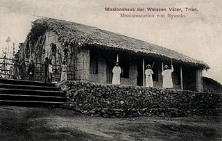
Nyundo is a community in the Rubavu District of Western Province, Rwanda, on the Sebeya River to the east of Gisenyi. It is the location of one of the first Catholic missions to be established in Rwanda, and today is the headquarters of the Roman Catholic Diocese of Nyundo.

The Sebeya River is a river in Western Province, Rwanda that empties into Lake Kivu just south of the town of Gisenyi.

Symbion Thermal Power Station is a 56 megawatts (75,000 hp) methane gas-fired thermal power plant located at the Cape of Busororo near the town of Nyamyumba in Rubavu District, in the Western Province of Rwanda.

<span class="mw-page-title-main">Rubona, Rwanda</span> Place in Western Province, Rwanda

Rubona, also Rubona Peninsula, is a neighborhood to the south of the city of Gisenyi in Rwanda.

The Rwanda Standard Gauge Railway is a standard gauge railway (SGR) system, under development, linking the country to the neighboring countries of Tanzania and Uganda. It is intended to ease the transfer of goods between the Indian Ocean ports of Dar es Salaam and Mombasa, and the Rwandan capital Kigali. The system is expected to link, in the future, to Rwanda's two other neighbors, Burundi and the Democratic Republic of the Congo, as part of the East African Railway Master Plan. With no previously existing railway network, Rwanda is developing its railway system from scratch. The project is dependent on the construction of the Tanzanian and Ugandan SGR lines to the Rwandan border, which have not been completed as of October 2023.

<span class="mw-page-title-main">2021 Mount Nyiragongo eruption</span> 2021 eruption of Mount Nyiragongo in the Democratic Republic of the Congo

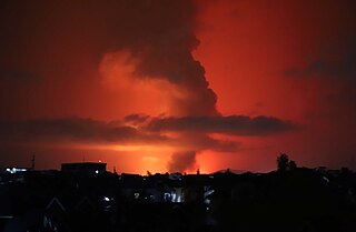
On 22 May 2021, Mount Nyiragongo in the Democratic Republic of the Congo began erupting. As of 25 May, 32 people died as a result of the eruption and 1,000 homes were destroyed.

References

  1. Citypopulation.de Population of Rubavu District
  2. "DR Congo's Nyiragongo volcano flares up". Nigeria's Top News Site. 2021-05-22. Retrieved 2021-05-22.
  3. polly (2019-08-20). "Rubavu District". Nyungwe Forest National Park. Retrieved 2020-10-11.
  4. "Rubavu gov" (PDF).
  5. 1 2 "Rubavu, Rwanda's resort town on the shores of Lake Kivu". Destination Kivu Belt. 2021-05-28. Retrieved 2021-10-04.
  6. "Rwanda Tea Tour at Pfunda". Destination Kivu Belt. 2021-06-02. Retrieved 2021-10-04.
  7. polly (2019-08-20). "Rubavu District". Nyungwe Forest National Park. Retrieved 2020-10-11.
  8. "Rubavu gov".

1°41′S29°20′E / 1.683°S 29.333°E / -1.683; 29.333