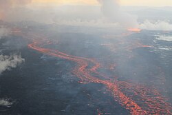
World map of active volcanoes and plate boundariesKīlauea's lava entering the seaLava flows at Holuhraun, Iceland, September 2014
An active volcano is a volcano that is currently erupting, or has the potential to erupt in the future.[1] Conventionally it is applied to any that have erupted during the Holocene (the current geologic epoch that began approximately 11,700 years ago). A volcano that is not currently erupting but could erupt in the future is also known as a dormant volcano.[1] Volcanoes that will not erupt again, or are thought to never erupt again, are known as extinct volcanoes.[1]
There are 1,650 potentially active volcanoes around the world, 500 of which have erupted in historical time.[2] Many active volcanoes are located along the Pacific Rim, also known as the Pacific Ring of Fire.[2][3] An estimated 500 million people live near active volcanoes.[3]
Historical time (or recorded history) is another timeframe for active.[4][5] The span of recorded history differs from region to region. In China and the Mediterranean, it reaches back nearly 3,000 years, but in the Pacific Northwest of the United States and Canada, it reaches back less than 300 years, and in Hawaii and New Zealand it is only around 200 years.[4] The incomplete Catalogue of the Active Volcanoes of the World, published in parts between 1951 and 1975 by the International Association of Volcanology, uses this definition, by which there are more than 500 active volcanoes.[4][6]As of March2021[update], the Smithsonian Institution's Global Volcanism Program recognizes 560 volcanoes with confirmed historical eruptions.[7]
Countries with the most Holocene volcanoes, according to the Smithsonian Institution's Global Volcanism Program (as of 2023[update]):[8]
United States: 165
Japan: 122
Russia: 117
Indonesia 117
Chile: 91
Countries with the most volcanoes active since 1960 (as of 2023[update]):[9]
Indonesia: 55
Japan: 40
US: 39 (mostly volcanic areas in and around Hawaii, Alaska, California, Oregon, Washington State and Pacific territories)
Russia: 27
Chile: 19
Papua New Guinea: 13
Ecuador: 12
As of 2025, the following are considered Earth's most active volcanoes:[10]
Mauna Loa in Hawaii is the largest active volcano in the world. Its summit is more than 4 kilometers (2.5mi) above sea level, and 17 kilometers (11mi) above its base in the sea floor.[11]
Argentina is part of the Andes Mountains volcanic belt along the western South American Pacific coast. These volcanoes are a result of subduction, where the Nazca Plate is subducting below the South American Plate. The following list are active/dormant volcanoes in Argentina:
↑Tilling, Robert I. (1997). "Volcano environment". Volcanoes. Denver, Colorado: U.S. Department of the Interior, U.S. Geological Survey. Retrieved August 16, 2012. There are more than 500 active volcanoes (those that have erupted at least once within recorded history) in the world
↑DeFelice, B.; Spydell, D.R.; Stoiber, R.E. (14 November 1997). "Catalogs of Active Volcanoes". The Electronic Volcano. Dartmouth College. Archived from the original on 2020-01-19. Retrieved 16 April 2021.
This page is based on this Wikipedia article Text is available under the CC BY-SA 4.0 license; additional terms may apply. Images, videos and audio are available under their respective licenses.