
Babuyan Claro Volcano, also known as Mount Pangasun, is an active volcano located on Babuyan Island, the northernmost of the Babuyan group of islands in Luzon Strait, north of the main island of Luzon in the Philippines. It is classified as one of the active volcanoes of the country with the last confirmed eruption in 1860.

Cagua Volcano is a stratovolcano located in the Philippine province of Cagayan. It is one of the active volcanoes in the Philippines and has erupted twice in recorded history. Its last eruption was in 1907.

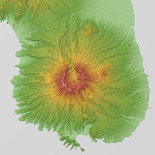
Mount Hibok-Hibok is a stratovolcano on Camiguin Island in the Philippines. It is one of the active volcanoes in the country and part of the Pacific ring of fire.

Mount Iraya, is an active stratovolcano on Batan Island and the highest point in the province of Batanes, Philippines.
Mount Ragang, also called Mount Piapayungan and Blue Mountain by the local people, is an active stratovolcano on Mindanao island in the Philippines. With an elevation of 2,815 metres (9,236 ft), it is the seventh highest mountain in the Philippines and the highest point in the Lanao del Sur province.

Mount Matutum is an active stratovolcano, is the highest point in the province of South Cotabato in the Philippines, with an elevation of 7,500 feet above sea level, approximately 5.7 kilometres (3.5 mi) from Acmonan, Tupi, South Cotabato. Matutum and its foothills are predominantly inhabited by indigenous Blaan families.

Mount Mélébingóy, formerly known as Parker Volcano, is an active volcano on Mindanao island in the Philippines. It is located in the province of South Cotabato, 30 km (19 mi) west of General Santos and 44 km (27 mi) south of Koronadal City.
Cancajanag is located within the municipal boundary of Dagami in the province of Leyte, on the island of Leyte, Region VIII, of the Philippines. It is located within the baranggays of Bouglayor and San Agustin.
Latukan Volcano is a potentially active stratovolcano in the centre of a chain of young E-W-trending stratovolcanoes in northwest Mindanao, southeast of Lake Lanao, province of Lanao del Sur, island of Mindanao, in the Bangsamoro Autonomous Region in Muslim Mindanao.
Mount Mandalagan is a complex volcano located at latitude 10.65° North (10°39'0"N), longitude 123.25° East (123°15'0"E), in the province of Negros Occidental, on the north of the island of Negros of the Philippines. It is located inside the Northern Negros Natural Park.
Patoc is a strongly fumarolic stratovolcano in the Philippines. Patoc is located in Mountain Province, part of the Cordillera Central range, on the island of Luzon, in the Philippines. It is located 6 cadastral kilometres north of Bontoc, at latitude 17.147°N (17°8'48"N), longitude 120.98°E (120°58'48"E).
Mount Labo, is a potentially active stratovolcano in the province of Camarines Norte, in the Bicol Region (Region V), on Luzon Island, in the Philippines. It is located at the northwest end of the Bicol Peninsula.
Mount Panay is a potentially active stratovolcano located in the province of Batangas, Philippines.
Mount Natib is a dormant stratovolcano and caldera complex in the province of Bataan on western Luzon Island of the Philippines. The volcano complex occupies the northern portion of the Bataan Peninsula. The mountain and adjacent surrounding is a protected area first declared as the Bataan National Park in 1945.
Mount Mariveles is a dormant stratovolcano and the highest point in the province of Bataan in the Philippines. Mariveles and the adjacent Mount Natib comprise 80.9 percent of the total land area of the province. The mountain and adjacent cones lie opposite the city of Manila across Manila Bay, providing a beautiful setting for the sunsets seen from the city.

Mount Balatukan is a massive potentially active compound stratovolcano in the Southern island of Mindanao, Philippines. It is the highest point in the province of Misamis Oriental. The volcano has no historical eruptions but displays fumarolic activity. The 2,560-metre (8,400 ft) mountain is topped by a triangular shaped caldera 15 kilometers (9.3 mi) long and 10.6 kilometers (6.6 mi) at its widest. The Balatocan River emanates from and drains the huge crater.
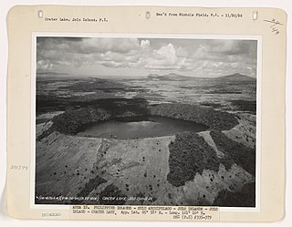
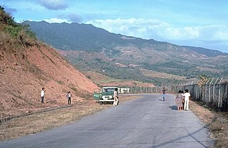
The Jolo Group of Volcanoes, more commonly referred to as the Jolo Group, are an active group of volcanoes in the island of Jolo in Southern Philippines. The Global Volcanism Program lists Jolo as one of the active volcanoes in the Philippines while the Philippine Institute of Volcanology and Seismology (PHIVOLCS) collectively list the group as Bud Dajo, one of the cinder cones on the island.
Balut Island, also known as Malulong, is a potentially active volcanic island south of the tip of Davao Occidental province in the Mindanao region, southern Philippines. At the center of the island is Balut Volcano, a fumarolic volcano with no historical eruptions.
Mahagnao Volcano also known as part of is a dormant stratovolcano located in the Barangay Mahagnao part of the municipality of Burauen province of Leyte, Philippines. It is also bounded by the municipalities of La Paz and MacArthur. The area is mostly composed of wetland forests and also the birth of many rivers and streams flowing on many part of Burauen and on its neighboring towns.
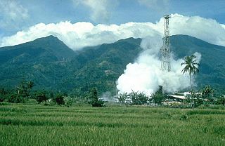
Mount Malinao is a potentially active stratovolcano located in the Bicol Region of the Philippines. The volcano displays strong fumarolic activity which is harnessed for generating electricity. Located on its slope is Tiwi Geothermal Power Plant, one of the first geothermal energy plant commissioned in the country.


