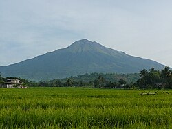
- Dulang-dulang, Philippines' 2nd highest
- Mayon, highest in the Bicol Region
The following is an incomplete list of mountains in the Philippines. Several of these are volcanoes, formed by subducting tectonic plates surrounding the archipelago. [1]
This list contains most of the highest mountains in the country. It is limited to mountain peaks with, if known, an elevation of at least 200 metres (660 feet) above sea level, and may include those considered as hills. The distinction between a hill and a mountain in terms of elevation is unclear and largely subjective, but a hill is universally considered to be less tall and less steep than a mountain. [2]
ultra prominent peak (with topographic prominence greater than 1,500 metres (4,900 feet)) [3] | |
ultra prominent peak [3] and highest in the island | |
‡ | active volcano (erupted within historical times (within the last 600 years) [1] |
† | potentially-active volcano (morphologically young-looking but with no historical records of eruption) [1] |
no data or inactive/extinct volcano (no record of eruptions; physical form is being changed by agents of weathering and erosion) [1] (check "Notes" section) |
Hills are easier to climb than mountains. They are less steep and not as high. But, like a mountain, a hill will usually have an obvious summit, which is its highest point.
The ravines are deep and steep slopes are covered only by cogon. The Ragay coast is hilly and rolling. Mt. Isarog with an elevation of 1, 976 meters and Mt. Iriga with 1, 196 meters, in the central and southern parts are inactive volcanoes. Also there is the Tangkong Baka mountain range which is the lower portion of the Sierra Madre mountain system and the Calinigan Mountain Range (904 meters) in the Partido area. Other mountains in the province are: Mt. Sugutin- 366m, Mt. Tiis- 610 m, Saddle Peak- 1,028m, Triple Peak- 638m, Mt. Putianay- 640m, Mt. Elizario- 508m, Mt. Talitig- 385m.
It's a nearly two hour trip from Cebu City to Osmeña Peak, the highest mountain in Cebu that is a favorite among hikers for its picturesque view of the countryside. Osmena Peak rises 1,013 meters above sea level and is nestled between the southern towns of Dalaguete and Badian. It straddles the Mantalongon range in the southwest and offers a 360 degree view of nature, including the islands of Bohol and Negros.
A must-see in this part of Cebu is Osmeña Peak, which stands 1013+ meters above sea level (MASL).
Going to Mt. Lantoy, Argao's second highest peak (1,945 ft. or 593 meters), involves many exciting and challenging activities, ...
Cagua Volcano is a stratovolcano located in the Philippine province of Cagayan. It is one of the active volcanoes in the Philippines and has erupted twice in recorded history. Its last eruption was in 1907.
Mount Iraya, is an active stratovolcano on Batan Island and the highest point in the province of Batanes, Philippines.
Mount Makaturing, also known locally as Palaw a Magatoring, is a stratovolcano on Mindanao island in the Philippines. It is found in the province of Lanao del Sur in the Bangsamoro Autonomous Region in Muslim Mindanao. Makaturing has an elevation of 1,940 metres (6,365 ft) and a base diameter of 29 km (18 mi). It is part of a string of volcanoes called the Central Mindanao Arc.
Mount Ragang, also called Mount Piapayungan and Blue Mountain by the local people, is an active stratovolcano on Mindanao island in the Philippines. With an elevation of 2,815 metres (9,236 ft), it is the seventh highest mountain in the Philippines and the highest point in Lanao del Sur.
Mount Matutum is an active stratovolcano, is the highest point in the province of South Cotabato in the Philippines, with an elevation of 7,500 feet above sea level, approximately 5.7 kilometres (3.5 mi) from Acmonan, Tupi, South Cotabato. Matutum and its foothills are predominantly inhabited by indigenous Blaan families.
Musuan Peak or Mount Musuan, also known as Mount Calayo is an active volcano in Maramag, Bukidnon, on the island of Mindanao in the Philippines. It is 4.5 kilometres (2.8 mi) south of the city of Valencia, province of Bukidnon, and 81 kilometres (50 mi) southeast of Cagayan de Oro.
Mount Leonard Kniaseff, or simply Leonard Kniaseff, is a stratovolcano between the municipalities of Mabini and Maco in the province of Davao de Oro, island of Mindanao, Philippines.
Mount Malindig is a large potentially active stratovolcano on the island of Marinduque in the Philippines. It is the highest peak in the island having an elevation of 1,157 metres (3,796 ft) above sea level.
Mount Talinis is a complex volcano in the Philippine province of Negros Oriental. At about 1,903 metres (6,243 ft) above sea level, it is the second highest mountain on Negros Island after Mount Kanlaon, and the tallest peak in the mountain range known as the Cuernos de Negros. The volcano is located 9 km (5.6 mi) southwest of the municipality of Valencia; and 20 km (12 mi) from Dumaguete, the capital of the province.
Mount Malindang is a complex volcano located in the province of Misamis Occidental in the southern island of Mindanao, Philippines. It is the highest point in the province. The least studied mountain range was formed through several volcanic activities some of which could be historical, evident by the presence of two calderas, surrounded by high rock walls, cinder cones, dome volcano plugs, two sulfurous hot springs, and a crater lake named Lake Duminagat. The amphitheater structures have extensive distribution of volcanic rocks, carbonized wood that are found in pyroclastic deposits. The mountain range is dissected by several canyons and ravines.
Mount Kalatungan, also known as Catatungan, is a volcanic mountain located in the province of Bukidnon in the southern Philippines. It is a stratovolcano with no known historical eruptions and classified by the Philippine Institute of Volcanology and Seismology (PHIVOLCS) as a potentially active volcano.
Mount Santo Tomas is a potentially active stratovolcano in the Philippines located in the municipality of Tuba in the province of Benguet. The mountain is part of the protected Santo Tomas Forest Reserve declared through Proclamation No. 581 signed by President Manuel L. Quezon on July 9, 1940.
The Pocdol Mountains, also known as Mount Pocdol, the Pocdol Hills, or the Bacon-Manito Volcanic Group, are a volcanic group of stratovolcanoes in the Philippines, straddling the boundary between the provinces of Albay and Sorsogon.
Mount Labo, is a potentially active stratovolcano in the province of Camarines Norte, in the Bicol Region (Region V), on Luzon Island, in the Philippines. It is located at the northwest end of the Bicol Peninsula.
Mount Natib is a dormant stratovolcano and caldera complex in the province of Bataan on western Luzon Island of the Philippines. The volcano complex occupies the northern portion of the Bataan Peninsula. The mountain and adjacent surrounding is a protected area first declared as the Bataan National Park in 1945.
Mount Masaraga is a stratovolcano located in Ligao City in the province of Albay, in the Bicol region, on Luzon Island, in the Philippines.
Mount Mariveles is a dormant stratovolcano and the highest point in the province of Bataan in the Philippines. Mariveles and the adjacent Mount Natib comprise 80.9 percent of the total land area of the province. The mountain and adjacent cones lie opposite the city of Manila across Manila Bay, providing a beautiful setting for the sunsets seen from the city.
Mount Malinao is a potentially active stratovolcano located in the Bicol Region of the Philippines. The volcano displays strong fumarolic activity which is harnessed for generating electricity. Located on its slope is Tiwi Geothermal Power Plant, one of the first geothermal energy plant commissioned in the country.