Geography of Yemen

Last updated
Geography of Yemen
Yemen relief location map.jpg
Continent Asia
Region Middle East
Coordinates 15°N48°E / 15°N 48°E / 15; 48
Area Ranked 49th
  Total555,000 km2 (214,000 sq mi)
Coastline1,906 km (1,184 mi)
Borders1,746 km (1,085 mi)
Oman: 288 km (179 mi)
Saudi Arabia: 1,458 km (906 mi)
Highest point Jabal An-Nabi Shu'ayb
3,667 m (12,031 ft)
Lowest point Arabian Sea
0 m (0 ft)
Natural resourcesOil, natural gas, rock salt, marble
Exclusive economic zone552,669 km2 (213,387 sq mi)

Yemen is located in Southwest Asia, at the southern tip of the Arabian Peninsula, between Oman and Saudi Arabia. It is situated at the entrance to the Bab-el-Mandeb Strait, which links the Red Sea to the Indian Ocean (via the Gulf of Aden) and is one of the most active and strategic shipping lanes in the world. Yemen has an area of 555,000 square kilometres (214,000 sq mi), including the islands of Perim at the southern end of the Red Sea and Socotra at the entrance to the Gulf of Aden. [1] Yemen's land boundaries total 1,746 kilometres (1,085 mi). Yemen borders Saudi Arabia to the north (1,458 km or 906 mi) and Oman to the northeast (288 km or 179 mi). [2] Through the Socotra island, Yemen also shares borders with the Guardafui Channel and the Somali Sea. [3]

Contents

Topography

Yemen's Koppen climate classification map is based on native vegetation, temperature, precipitation and their seasonality.
.mw-parser-output .legend{page-break-inside:avoid;break-inside:avoid-column}.mw-parser-output .legend-color{display:inline-block;min-width:1.25em;height:1.25em;line-height:1.25;margin:1px 0;text-align:center;border:1px solid black;background-color:transparent;color:black}.mw-parser-output .legend-text{}
BWh Hot desert
BWk Cold desert
BSh Hot semi-arid
BSk Cold semi-arid
CWb Subtropical highland Koppen-Geiger Map YEM present.svg
Yemen's Köppen climate classification map is based on native vegetation, temperature, precipitation and their seasonality.
Yemen-map.png
Map of Yemen
Tihama on the Red Sea near Khaukha, Yemen.jpg
The Tihamah
Wadi Dhar.jpg
Wadi Dhar
Yemen landscape 05.jpg
Agricultural terraces in the Haraz-Sarat Mountains

Yemen occupies the southern end of the Arabian Plate. [5]

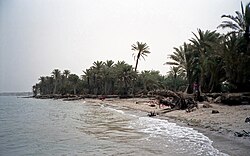
The country's mountainous interior is surrounded by narrow coastal plains to the west, south, and east and by upland desert to the north along the border with Saudi Arabia. The Tihamah is a nearly 419-kilometre (260 mi) long, semidesert coastal plain that runs along the Red Sea and is part of the Arabian Peninsula coastal fog desert ecoregion. The highland regions are interspersed with wadis, or river valleys, that are dry in the winter months (Yemen has no permanent rivers.) Most notable is the Wadi Hadhramaut in eastern Yemen, the upper portions of which contain alluvial soil and floodwaters and the lower portion of which is barren and largely uninhabited. Both the eastern plateau region and the desert in the north are hot and dry with little vegetation. [2]

In the northeastern Empty Quarter, sands highlight the region, being the largest expanse of sand in the world. It receives little to no rain for extensive periods of time. Little vegetation grows here either. The central highlands are drier than the western highlands because of rain-shadow influences, but still receives sufficient rain in wet years for extensive cropping. Its diurnal temperature variations are among the highest in the world: ranges from 30  °C (86  °F ) in the day to 0 °C (32 °F) at night are normal. Water storage allows for irrigation and the growing of wheat and barley while the western highlands are famous for sorghum, coffee, and some tropical fruits like bananas and mangos.

Elevation

Yemen is a continuously elevated country, with only the coastal plains being the lowest-lying areas. Jagged peaks and plateaus cover most of Yemen, and the average elevation in the country is about 2,000 metres (6,600 ft). The interior mountains have elevations ranging from a few hundred meters to the highest point in the country and the Arabian Peninsula, Jabal An-Nabi Shu'ayb, which is 3,666 m (12,028 ft) above sea level, within the Harazi subrange of the Sarawat. [6] [7] The range of elevation is thus from sea level to 3,666 metres (12,028 ft), and among the countries in the Arab world, it is the one with the second highest high point, after Morocco's 4,167 metres (13,671 ft) high Jbel Toubkal. The Yemenis used the elevation of their homeland to stay isolated for thousands of years with foreign trade conducted only when the Yemenis wished to go to the coastal areas. The mountains are young, jagged peaks that are known to rise from an elevation of a few hundred meters to well over 3,000 m (9,800 ft). The mountains can be separated into a western and central highland. The western highlands have peaks reaching around 3,000 metres (1.9 miles), with relatively fertile soil and sufficient and plentiful rainfall. The central highlands is more like a plateau of about 2,000–3,200 metres (1.2–2.0 miles), with rolling hills, small knolls, and some very prominent peaks, but is still relatively more elevated. Less rainfall can be seen in this region, but the summer months give enough to sustain crops.

Climate

Temperatures are lower in most of Yemen than in most of the Arab world due to most of the country being at high elevation. Rainfall is higher at higher elevations. The highlands enjoy a temperate, rainy summer with an average high temperature of 21 °C (69.8 °F) and a cool, moderately dry winter with temperatures occasionally dipping below 0 °C (32.0 °F). The climate of the Tihamah (western coastal plain) is tropical; temperatures occasionally exceed 54 °C (129.2 °F), and the humidity ranges from 50 to 70 percent. Rainfall, which comes in irregular heavy torrents, averages 130 millimetres (5.12 in) annually. In Aden the average temperature is 25 °C (77.0 °F) in January and 32 °C (89.6 °F) in June, but with highs often exceeding 37 °C (98.6 °F). Average annual rainfall is 127 millimetres (5 in). The highest mountainous areas of southern Yemen receive from 520 to 760 mm (20.5 to 29.9 in) of rain a year. Some areas of the western highlands, most notably Ibb and Ta'izz, receive from about 1,000–1,500 millimetres (39.4–59.1 in) of rain each year. The capital, Sana'a, receives around 300 mm (11.8 in) a year, it is not uncommon for the northern and eastern sections of the country to receive no rain for five years or more. The Wadi Hadhramaut in the eastern part of Yemen is arid and hot, and the humidity ranges from 35 percent in June to 64 percent in January. Yemen has the most fertile land in the Arabian peninsula.

Climate data for Sanaa, Yemen
MonthJanFebMarAprMayJunJulAugSepOctNovDecYear
Record high °C (°F)30
(86)
31
(88)
32
(90)
32
(90)
37
(99)
39
(102)
41
(106)
38
(100)
40
(104)
34
(93)
33
(91)
31
(88)
41
(106)
Average high °C (°F)22.3
(72.1)
24.7
(76.5)
25.6
(78.1)
24.8
(76.6)
25.7
(78.3)
28.2
(82.8)
26.6
(79.9)
25.9
(78.6)
25.1
(77.2)
22.2
(72.0)
20.3
(68.5)
20.5
(68.9)
24.3
(75.8)
Daily mean °C (°F)12.6
(54.7)
14.1
(57.4)
16.3
(61.3)
16.6
(61.9)
18.0
(64.4)
19.3
(66.7)
20.0
(68.0)
19.6
(67.3)
17.8
(64.0)
15.0
(59.0)
12.9
(55.2)
12.4
(54.3)
16.2
(61.2)
Average low °C (°F)3.0
(37.4)
3.6
(38.5)
7.0
(44.6)
8.5
(47.3)
10.4
(50.7)
10.5
(50.9)
13.4
(56.1)
13.3
(55.9)
10.6
(51.1)
7.9
(46.2)
5.5
(41.9)
4.4
(39.9)
8.2
(46.7)
Record low °C (°F)−4
(25)
−1
(30)
1
(34)
4
(39)
1
(34)
9
(48)
5
(41)
0
(32)
3
(37)
1
(34)
−1
(30)
−2
(28)
−4
(25)
Average precipitation mm (inches)5
(0.2)
5
(0.2)
17
(0.7)
48
(1.9)
29
(1.1)
6
(0.2)
50
(2.0)
77
(3.0)
13
(0.5)
2
(0.1)
8
(0.3)
5
(0.2)
265
(10.4)
Average rainy days23455445332141
Average relative humidity (%)39.335.838.541.136.027.240.145.529.929.038.137.736.5
Mean daily sunshine hours 8889986789988
Source 1: Climate-Data.org (altitude: 2259m), [8] Weather2Travel (rainy days, sunshine) [9]
Source 2: Climatebase.ru (humidity), [10] Voodoo Skies (records) [11]
Climate data for Aden
MonthJanFebMarAprMayJunJulAugSepOctNovDecYear
Record high °C (°F)31.1
(88.0)
31.7
(89.1)
35.0
(95.0)
37.8
(100.0)
41.1
(106.0)
41.1
(106.0)
41.1
(106.0)
42.8
(109.0)
38.3
(100.9)
38.9
(102.0)
35.0
(95.0)
32.8
(91.0)
42.8
(109.0)
Average high °C (°F)28.5
(83.3)
28.6
(83.5)
30.2
(86.4)
32.2
(90.0)
34.1
(93.4)
36.6
(97.9)
35.9
(96.6)
35.3
(95.5)
35.4
(95.7)
33.0
(91.4)
30.7
(87.3)
28.9
(84.0)
32.4
(90.3)
Daily mean °C (°F)25.7
(78.3)
26.0
(78.8)
27.2
(81.0)
28.9
(84.0)
31.0
(87.8)
32.7
(90.9)
32.1
(89.8)
31.5
(88.7)
31.6
(88.9)
28.9
(84.0)
27.1
(80.8)
26.0
(78.8)
29.1
(84.4)
Average low °C (°F)22.6
(72.7)
23.2
(73.8)
24.0
(75.2)
25.6
(78.1)
27.7
(81.9)
28.8
(83.8)
28.0
(82.4)
27.5
(81.5)
27.8
(82.0)
24.6
(76.3)
23.2
(73.8)
22.9
(73.2)
25.5
(77.9)
Record low °C (°F)15.6
(60.1)
17.2
(63.0)
18.9
(66.0)
18.9
(66.0)
21.1
(70.0)
23.9
(75.0)
22.8
(73.0)
23.3
(73.9)
25.0
(77.0)
18.9
(66.0)
18.3
(64.9)
16.7
(62.1)
15.6
(60.1)
Average precipitation mm (inches)6
(0.2)
3
(0.1)
5
(0.2)
2
(0.1)
1
(0.0)
0
(0)
3
(0.1)
3
(0.1)
5
(0.2)
1
(0.0)
3
(0.1)
5
(0.2)
36
(1.4)
Average precipitation days (≥ 0.1 mm)32221122111320
Average relative humidity (%)72727474726665656968707070
Mean monthly sunshine hours 241.8203.4217.0240.0303.8282.0241.8269.7270.0294.5285.0257.33,106.3
Mean daily sunshine hours 7.87.27.08.09.89.47.88.79.09.59.58.38.5
Source: Deutscher Wetterdienst [12]

Coastline and maritime claims

Yemen has 2,400 kilometres (1,500 mi) of coastline along the Arabian Sea, the Gulf of Aden, and the Red Sea. Yemen claims a territorial sea of 12 nautical miles (13.8  mi ; 22.2  km ), a contiguous zone of 24 nautical miles (27.6 mi; 44.4 km), an Exclusive Economic Zone of 552,669 km2 (213,387 sq mi) based on 200 nautical miles (230.2 mi; 370.4 km). It has a continental shelf of 200 nautical miles (230.2 mi; 370.4 km) or to the edge of the continental margin. [2]

Natural resources

Yemen's principal natural resources are oil and natural gas as well as agriculturally productive land in the west. Other natural resources include fish and seafood, rock salt, marble, and major unexplored deposits of coal, gold, lead, nickel, and copper. [2]

Land use

Only 2.91 percent of Yemen is considered to be arable land, and less than 0.6 percent of the land is planted with permanent crops. About 6,801 square kilometres (2,626 sq mi) of the land is irrigated. According to the United Nations, Yemen has 19,550 square kilometres (7,550 sq mi) of forest and other wooded land, which constitutes almost 4 percent of total land area. [2]

Environmental factors

Yemen is subject to sandstorms and dust storms, resulting in soil erosion and crop damage. The country has very limited natural freshwater and consequently inadequate supplies of potable water. Desertification (land degradation caused by aridity) and overgrazing are also problems. [2] It is a party to international Biodiversity, Climate Change, Desertification, Endangered Species, Environmental Modification, Hazardous Wastes, Law of the Sea, and Ozone Layer Protection agreements. [13]

Disputed territory

A long-standing dispute between Saudi Arabia and Yemen was resolved in June 2000 with the signing of the Treaty of Jeddah. This agreement provides coordinates for use in delineating the land and maritime border, including the section in the eastern desert region of Yemen that potentially contains significant amounts of oil. Friction between the two countries in recent years over security of the borders appears to have been alleviated by the establishment of joint border patrols. Following years of dispute between Yemen and Eritrea over ownership of the Hanish Islands and fishing rights in the Red Sea, in 1999 an international arbitration panel awarded sovereignty of the islands to Yemen. Relations between the two countries remain strained, however, and Yemen continues to protest Eritrean fishing in the disputed territory. [2]

See also

Related Research Articles

<span class="mw-page-title-main">Geography of Djibouti</span> Country geography

Djibouti is a country in the Horn of Africa. It is bordered by Eritrea in the north, Ethiopia in the west and south, and Somalia in the southeast. To the east is its coastline on the Red Sea and the Gulf of Aden. Rainfall is sparse, and most of the territory has a semi-arid to arid environment. Lake Assal is a saline lake which lies 155 m (509 ft) below sea level, making it the lowest point on land in Africa and the third-lowest point on Earth after the Sea of Galilee and the Dead Sea. Djibouti has the fifth smallest population in Africa. Djibouti's major settlements include the capital Djibouti City, the port towns of Tadjoura and Obock, and the southern cities of Ali Sabieh and Dikhil. It is the forty-six country by area in Africa and 147st largest country in the world by land area, covering a total of 23,200 km2 (9,000 sq mi), of which 23,180 km2 (8,950 sq mi) is land and 20 km2 (7.7 sq mi) is water.

<span class="mw-page-title-main">Geography of Iraq</span> Geographic features of Iraq

The geography of Iraq is diverse and falls into five main regions: the desert, Upper Mesopotamia, the northern highlands of Iraq, Lower Mesopotamia, and the alluvial plain extending from around Tikrit to the Persian Gulf.

<span class="mw-page-title-main">Geography of Jordan</span> Geographical features of Jordan

Jordan is situated geographically in Southwest Asia, south of Syria, west of Iraq, northwest of Saudi Arabia, east of Israel. The area is also referred to as the Middle or Near East. The territory of Jordan now covers about 91,880 square kilometres (35,480 sq mi).

<span class="mw-page-title-main">Geography of Oman</span> Geographical features of Oman

Oman is a country on the southeast coast of the Arabian Peninsula, situated in Southwest Asia, bordering the Arabian Sea, Gulf of Oman, and Persian Gulf, between Yemen and the United Arab Emirates (UAE). The coast of Oman was an important part in the Omani empire and sultanate.

<span class="mw-page-title-main">Geography of Panama</span>

Panama is a country located in Central America, bordering both the Caribbean Sea and the Pacific Ocean, between Colombia and Costa Rica. Panama is located on the narrow and low Isthmus of Panama.

<span class="mw-page-title-main">Geography of Saudi Arabia</span> Overview of the geography of the Kingdom of Saudi Arabia

The Kingdom of Saudi Arabia is a country situated in Southwest Asia, the largest country of Arabia, by the Arabian Peninsula, bordering the Persian Gulf and the Red Sea, north of Yemen. Its extensive coastlines on the Persian Gulf and Red Sea provide great leverage on shipping through the Persian Gulf and the Suez Canal. The kingdom occupies 80% of the Arabian Peninsula. Most of the country's boundaries with the United Arab Emirates (UAE), Oman, and the Republic of Yemen are undefined, so the exact size of the country remains unknown. The Saudi government estimate is at 2,217,949 square kilometres, while other reputable estimates vary between 2,149,690 and 2,240,000 sq. kilometres. Less than 7% of the total area is suitable for cultivation, and in the early 1960s, population distribution varied greatly among the towns of the eastern and western coastal areas, the densely populated interior oases, and the vast, almost empty deserts.

<span class="mw-page-title-main">Geography of Syria</span> Geographical features of Syria

Syria is located in Western Asia, north of the Arabian Peninsula, at the eastern end of the Mediterranean Sea. It is bordered by Turkey to the north, Lebanon and Israel to the west and southwest, Iraq to the east, and Jordan to the south. It consists of mountain ranges in the west and a steep area inland. In the east is the Syrian Desert and in the south is the Jabal al-Druze Range. The former is bisected by the Euphrates valley. A dam built in 1973 on the Euphrates created a reservoir named Lake Assad, the largest lake in Syria. The highest point in Syria is Mount Hermon on the Lebanese border at 2,814 metres or 9,232 feet. Between the humid Mediterranean coast and the arid desert regions lies a semiarid steep zone extending across three-quarters of the country, which receives hot, dry winds blowing across the desert. Syria is extensively depleted, with 28 percent of the land arable, 4 percent dedicated to permanent crops, 46 percent utilized as meadows and pastures, and only 3 percent forest and woodland.

<span class="mw-page-title-main">Geography of the United Arab Emirates</span> List of the United Arab Emirates geographical features

The United Arab Emirates is situated in the Middle East and southwest Asia, bordering the Gulf of Oman and the Persian Gulf, between Oman and Saudi Arabia; it is at a strategic location along the northern approaches to the Strait of Hormuz, a vital transit point for world crude oil. The UAE lies between 22°50′ and 26° north latitude and between 51° and 56°25′ east longitude. It shares a 19 km (12 mi) border with Qatar on the northwest, a 530 km (330 mi) border with Saudi Arabia on the west, south, and southeast, and a 450 km (280 mi) border with Oman on the southeast and northeast.

<span class="mw-page-title-main">Arabian Peninsula</span> Peninsula in Western Asia

The Arabian Peninsula, or Arabia, is a peninsula in Western Asia, situated northeast of Africa on the Arabian Plate. At 3,237,500 km2 (1,250,000 sq mi), the Arabian Peninsula is the largest peninsula in the world. It is also known as the Arabian subcontinent.

<span class="mw-page-title-main">Geography of Mexico</span> Overview of the geography of Mexico

The geography of Mexico describes the geographic features of Mexico, a country in the Americas. Mexico is located at about 23° N and 102° W in the southern portion of North America. From its farthest land points, Mexico is a little over 3,200 km (2,000 mi) in length. Mexico is bounded to the north by the United States, to the west and south by the Pacific Ocean, to the east by the Gulf of Mexico, and to the southeast by Belize, Guatemala, and the Caribbean Sea. The northernmost constituent of Latin America, it is the most populous Spanish-speaking country in the world. Mexico is the world's 13th largest country, three times the size of Texas.

The Geography of Guyana comprises the physical characteristics of the country in Northern South America and part of Caribbean South America, bordering the North Atlantic Ocean, between Suriname and Venezuela, with a land area of approximately 214,969 square km. The country is situated between 1 and 9 north latitude and between 56 and 62 west longitude. With a 459 km (285 mi)-long Atlantic coastline on the northeast, Guyana is bounded by Venezuela on the west, Brazil on the west and south, and Suriname on the east.

<span class="mw-page-title-main">Geography of Somalia</span> Geographical features of Somalia

Somalia is a country located in the Horn of Africa which officially consists of the intra-46th meridian east territory, the five federal member states, namely Galmudug, Hirshabelle, Jubaland, South West, Puntland and the municipality of Benadir. It is bordered by Ethiopia to the west, the Gulf of Aden to the north, the Somali Sea and Guardafui Channel to the east, and Kenya to the southwest. With a land area of 637,657 square kilometers, Somalia's terrain consists mainly of plateaus, plains and highlands. Its coastline is more than 3,333 kilometers in length, the longest of mainland Africa. It has been described as being roughly shaped "like a tilted number seven".

<span class="mw-page-title-main">Sarawat Mountains</span> Mountain range in Saudi Arabia and Yemen

The Sarawat Mountains, also known as the Sarat, is a part of the Hijaz Mountains in the western part of the Arabian Peninsula. In a broad sense, it runs parallel to the eastern coast of the Red Sea, and thus encompasses the mountains of Fifa', 'Asir and Taif. In a narrow sense, the Sarawat start in Taif city in Saudi Arabia, and extend to the Gulf of Aden in the south, running along the entire western coast of Yemen, in what used to be North Yemen, and extend eastwards into part of what used to be South Yemen, thus running parallel to the Gulf of Aden.

<span class="mw-page-title-main">Arabian Peninsula coastal fog desert</span> Ecoregion on the southern coasts of the Arabian Peninsula

The Arabian Peninsula coastal fog desert, also known as the Southwestern Arabian coastal xeric scrub, is desert ecoregion on the southern coasts of the Arabian Peninsula, which experiences thick fogs where visibility may be reduced to 10 metres (33 ft). It is classed as an Afrotropical fog desert

The wildlife of Yemen is substantial and varied. Yemen is a large country in the southern half of the Arabian Peninsula with several geographic regions, each with a diversity of plants and animals adapted to their own particular habitats. As well as high mountains and deserts, there is a coastal plain and long coastline. The country has links with Europe and Asia, and the continent of Africa is close at hand. The flora and fauna have influences from all these regions and the country also serves as a staging post for migratory birds.

<span class="mw-page-title-main">Southwestern Arabian foothills savanna</span>

The Southwestern Arabian foothills savanna, also known as the Southwestern Arabian Escarpment shrublands and woodlands, is a desert and xeric shrubland ecoregion of the southern Arabian Peninsula, covering portions of Saudi Arabia, Yemen, and Oman.

<span class="mw-page-title-main">South Arabian fog woodlands, shrublands, and dune</span>

The South Arabian fog woodlands, shrublands, and dune is an ecoregion in Oman and Yemen. The fog woodlands lie on mountainsides which slope southeastwards towards the Arabian Sea. The mountains intercept moisture-bearing winds from the Arabian Sea, creating orographic precipitation and frequent fogs that sustain unique woodlands and shrublands in a desert region.

<span class="mw-page-title-main">Red Sea Nubo–Sindian tropical desert and semi-desert</span>

The Red Sea Nubo–Sindian tropical desert and semi-desert ecoregion covers extremely arid land along the northeastern Red Sea, the southern Sinai Peninsula, and on a thin strip along the Israel-Jordan border. Most of the coastal land is flat, but there are high mountains in southern Sinai. Biodiversity is limited by the low moisture levels - some areas go for years without significant rain. Portions of the area support a thin savannah-like cover of widely scattered trees and scrub, surrounded by grasses that briefly flourish after a rainfall. Biodiversity is highest in the mountains of Sinai, and in the wadis and gullies that retain moisture.

<span class="mw-page-title-main">Geography of Somaliland</span> Land features of Somaliland

Somaliland is an unrecognised sovereign state in the Horn of Africa, internationally considered to be part of Somalia.
Somaliland is located in the East African sub-continent between the equator and the Gulf of Aden. The country occupies an area of approximately 176,120 square kilometres (68,000 sq mi). The climate is mostly hot and desertlike; it is largely arid with some semi-arid regions.

<span class="mw-page-title-main">Tarim, Hadhramaut</span> Town in Hadhramaut, Yemen

Tarim is a historic town situated in Wadi Hadhramaut in Yemen, in the southern part of the Arabian Peninsula. It is widely acknowledged as the theological, juridical, and academic center of the Hadhramaut Valley. An important focus of Islamic learning, it is estimated to contain the highest concentration of descendants of the Islamic Prophet Muhammad (sayyids) anywhere in the world. The city is distinguished for producing numerous Islamic scholars, including Imam al-Haddad. Additionally, Tarim is also home to Dar al-Mustafa, a well-known educational institute for the study of traditional Islamic Sciences.

References

  1. "About Yemen". Ministry of Oil and Minerals.
  2. 1 2 3 4 5 6 7 "Country Profile: Yemen" (PDF). Federal Research Division . United States Library of Congress. August 2008. Archived from the original (PDF) on 16 March 2015. Retrieved 23 May 2019.This article incorporates text from this source, which is in the public domain.
  3. McLaughlin, Rob. "The Continuing Conundrum of the Somali Territorial Sea and Exclusive Economic Zone." The International Journal of Marine and Coastal Law 30.2 (2015): 305-334.
  4. Peel, M. C. and Finlayson, B. L. and McMahon, T. A. (2007). "Updated world map of the Köppen–Geiger climate classification". Hydrol. Earth Syst. Sci. 11 (5): 1633–1644. Bibcode:2007HESS...11.1633P. doi: 10.5194/hess-11-1633-2007 . ISSN   1027-5606.{{cite journal}}: CS1 maint: multiple names: authors list (link)(direct: Final Revised Paper)
  5. Hadden, R. L. (2012), The Geology of Yemen: An Annotated Bibliography of Yemen's Geology, Geography, and Earth Science, Alexandria, VA: Army Geospatial Center, U.S. Army Corps of Engineers
  6. Robert D. Burrowes (2010). Historical Dictionary of Yemen. Rowman & Littlefield. pp. 5–340. ISBN   978-0-8108-5528-1.
  7. McLaughlin, Daniel (2008). "1: Background". Yemen. Bradt Travel Guides. p. 3. ISBN   978-1-8416-2212-5.
  8. "Climate: Sanaa - Climate graph, Temperature graph, Climate table". Climate-Data.org. Retrieved 2014-02-23.
  9. "Sana Climate and Weather Averages, Yemen". Weather2Travel. Retrieved 2014-02-23.
  10. "Sanaa, Yemen". Climatebase.ru. Retrieved 2014-02-23.
  11. "Sanaa, Yemen". Voodoo Skies. Retrieved 2014-02-23.
  12. "Klimatafel von Aden-Chormaksar / Jemen" (PDF). Baseline climate means (1961–1990) from stations all over the world (in German). Deutscher Wetterdienst. Retrieved 25 February 2016.
  13. "Yemen". The World Factbook . United States Central Intelligence Agency . Retrieved 23 May 2019.