A fertile floodplain and tropical monsoon climate, ideally suited to wet-rice (tham na) cultivation, attracted settlers to this central area in preference to the marginal uplands and the highlands of the northern region or the Khorat Plateau to the northeast.[4]
By the 11th century AD, a number of loosely connected rice-growing and trading states flourished in the upper Chao Phraya Valley.[4] They broke free from domination of the Khmer Empire, but from the middle of the 14th century gradually came under the control of the Ayutthaya Kingdom at the southern extremity of the floodplain.[4]
Successive capitals, built at various points along the river, became centers of great Thai kingdoms based on rice cultivation and international commerce.[4] Unlike the neighboring Khmer and Burmese, the Thai continued to look outward across the Gulf of Thailand and the Andaman Sea toward foreign ports of trade.[4]
European colonisation of Southeast Asia brought a new phase of Southeast Asian commerce in the late-1800s. Thailand (then called Siam) was able to maintain its independence as a buffer zone between British-controlled Burma to the west, British Malaya to the south, and French Indochina to the east.[4] However, Thailand lost over 50% of its former territory to the expanding claims of French Indochina until 1907. Its central location made the Kingdom of Thailand's position a regional hub that has greatly influenced its society, culture and history. Southern Thailand has a long, narrow shape. It is the only land connection to Malaysia and Singapore.
The mountain ranges that run parallel from north to south across Mainland Southeast Asia are one of Thailand's most distinctive geographical features.[6] The country's highest peak is Doi Inthanon, with an elevation of 2,565 meters.[7] Major mountain ranges include the Thanon Thong Chai Range, the Daen Lao Range on Thailand's northern edge, and the Tenasserim Hills on the border with Myanmar. The average elevation decreases southward.[8] There are no volcanoes.[9] There are 10 mountains over 2,000m (6,600ft). 148 mountains exceed 1,000m (3,300ft).
Northern Thailand's mountainous regions like Chiang Mai and Doi Inthanon have chilly air and misty mornings.[10] However, at high altitudes it does not get colder than 5°C to 10°C due to the tropical climate.[10] There is no snow and frost is rare in the coldest months.[10] In 1955, snow-like frost was reported in Doi Inthanon.[10]
The geographic shape of Thailand resembles an elephant's head with a long trunk.[20][21][22] There are 2 big ears, the Bay of Bangkok is a mouth and Southern Thailand is a long trunk that reaches down the Malay Peninsula.[21] The westside is the front of the head. The elephant holds deep cultural significance and it's a national symbol of Thailand.[20][23] The elephant also symbolizes Thailand’s natural heritage and fills a vital role in the ecosystems of the region.[24] It's also considered a "golden axe".[22][25] The broad northern regions are the double-bitted part of the axe like a labrys. The narrow southern “tail” is the handle.[25] The shape changed during the various kingdoms such as Sukhothai, Ayutthaya, and Rattanakosin.[22]
Plains
Thailand has large plains, valleys and basins.
Forests
The forest cover rate was 63% in the 1940s, but declined to 53.3% in the 1960s and 26.6% in 1991.[26] It had been declining due to timber exports, urbanization, and development.[27] Since the late 1980s, the decline has been halted since protective measures such as banning logging of natural forests were implemented.[26] As of 2020, the Royal Forest Department has classified the country's forests as 31.6% and 38.9% according to the FAO, remaining stable.[27][a]
There are around 8000 natural lakes and swamps.[32] This includes a few large lakes and thousands of small lakes. Songkhla lake is the largest natural lake at 1,040km2 (400mi2).
The source of Khao Phang Waterfall and Sai Yok Noi waterfall. The waterfall is 1500 meters long and has 7 tiers consisting of: ‘Lai Kuen Rang’, ‘Wang Matcha’, ‘Pha Nam Tok’, ‘Oak Phee Sua’ , ‘Bua Mai Long’ , ‘Dong Prueksa’ , and ‘Phu Pha Erawan’.
There are approximately 1,430 islands.[34] They are relatively small-sized islands and uninhabited islets. Many islands are protected areas in national parks or wildlife sanctuaries. Most islands are near the coasts of Southern Thailand and Eastern Thailand. The largest island is Phuket543km2 (210mi2) in the Andaman Sea.[35]
Present-day Thailand is theorized to have formed during the Triassic period when two continental fragments: Shan-Thai and Cimmeria formed during the breakup of Gondwana.[37] Shan-Thai and Cimmeria collided and merged, eventually moving northward and connecting with Laurasia.[37] Geologically, Thailand is divided into the Western Zone, which belongs to the Shan-Thai terrane; the Northeastern Zone, which belongs to the Indochina Block; and the Central Zone, which is located between the Western and Northeastern Zones.[38]
The northeastern part of Thailand is a relatively stable plateau, with only the Mesozoic, Jurassic and Cretaceoussandstone and shale being uplifted by Tertiary tectonic activity.[30] Most of the rest of the country exhibits a complex geological structure, consisting primarily of Paleozoiclimestone and other sedimentary rocks, and Precambrian metamorphic rocks.[39] Late Mesozoic granite is found in the Western Zone, while Paleozoic and Mesozoic neutral or acidic volcanic rocks are abundant in the Central Zone.[40]
Although seismic activity is not particularly high, there are 13 known active faults, mainly in the northwest and central-southwest, and in 2014 the northern part of the country experienced one of the largest earthquakes ever recorded (the 2014 Mae Lao earthquake), measuring 6.3 on the Richter scale.[41]
General soil conditions
Type
Description
Map
Soils of the alluvial plains and the lower terraces
Regosols on beach and dune sand
Alluvial soils on recent alluvium (fresh water alluvium, B a brackish water alluvium, M a marine alluvium).
Peat and Muck soils
Low - Humic Gley soils on semi-recent and old alluvium
Low - Humic Gley soils and noncalcic Brown soils on semi-recent alluvium
Low- Humic Gley soils and Gray Podzolic soils or Red - Yellow Podzolic soils on old alluvium
General soil conditions of Thailand map, 1967
Soils of the higher terraces and the low plateaus
Gray Podzolic soils on old alluvium
Red - Yellow Podzolic soils on old alluvium
Latosols, mainly on old alluvium, but including Latosols on materials from basalt (Chanthaburi)
Grumusols, Rendzinas and related soils on alluvial and residual materials, associated with limestone and basalt
Red- Brown Earths on alluvial and residual materials, associated with limestone
Reddish - brown lateritic soils on materials from intermediate to basic rocks.
Soils of the Hills and the mountains
Red - Yellow Podzolic soils; mostly hilly, on materials from acid to intermediate rocks.
Steep Land, intermediate to basic rocks, mainly Red - yellow Podzolic soils and reddish - Brown Lateritic soils
Steep Land, acid to intermediate rocks, mainly red - yellow Podzolic soils
Steep Land, limestone crags and Red - Brown Earths
Lava plateaus and volcanos, shallow undifferentiated soils.
Main land forms
Type
Description
Map
Land forms in transported material
Beach and dune formations
Active and former tidal flats of recent marine and brackish water deposits
Former tidal flats of older brackish water deposits
Flood plains of recent river alluvium
Low alluvial terraces of semi-recent and old alluvium
High alluvial terraces and fans of old alluvium and colluvium
Main landforms of Thailand soil formation map, 1972
Land forms in organic material
Depressions with peat and muck
Land forms in residual material
Dissected erosion surfaces and structural plateaux occuring over various rocks.
Lava plateaux and volcano remnants
Limestone outcrops
Hills and mountains
Soils and surface rocks
Type
Description
Map
Soils and surface rocks
(estimated conditions in 1949)
Bangkok dark heavy clay: profiles not well developed.
Ongkarak clays: marked profile development. Soils very acid.
Thachin clays: saline mangrove swamps and grass lands. Fresh water swamps in the interior.
Kampangsaen loams: medium textured soils with strips of heavier darker soils. Irrigation needed for effective crop production.
Chiengmai loams: recent alluvial soils and some terraces, especially in mountain valleys.
Yom loams and clays: swamps and natural levees between the Yom and Nan rivers in the upper central valley.
Bangkla silt loams: light colored and infertile.
Lopburi clays: calcareous, with marl below. Includes other clays back from the rivers in the upper central valley.
Chaibadan clays: black, shallow and infertile, from igneous rocks.
Chantaburi clays: red, friable, deep , from igneous rocks.
Krabin gravelly loam: red with abundant ferruginous concretions.
Korat fine sandy loams: often with pisolitic laterite in the subsoil. Includes Kumpawapi sandy loams: deeper soils on elevations, without a laterite horizon.
Roi Et fine sandy loams: lower portion of type 5 diked and planted to rice. Most often these areas in type 5 too small to plot on map of this scale.
Gularonghai silt loams: flat grassy plains. Not suited for crop production unless waters controlled and fertilizers applied.
Pattani coastal soils: sandy ridges alternating with strips of low clay rice soils.
Limestone buttes: often precipitous, usually rough topography. Includes some lower, heavy soils from weathering of limestone.
Kuntan sandy loams: shallow and steep, soils from granitic and metamorphic rocks topography hilly to mountainous.
Sritamarat sandy and coarse sandy loams: the footslopes of granitic mountains.
Quartzitic and silicious sandstone hills and the sandy soils from these rocks. Soils usually shallow; at times stony.
Pakchong loams: from shales, slates, conglomerates, limestones, etc. Textures usually much heavier than the soils mapped under type 42.
Rough mountainous land from undifferentiated rocks: Soils usually shallow, steep and stony. Crop production by Kaingining.
Provisional map of soils and surface rocks of Thailand 1949
The Gulf of Thailand was historically called the Gulf of Siam until the country was renamed to Thailand in 1939. It is geographically defined by Thailand which encloses the body of water for circa 3/4th of the coastline.
Bays
The Thai sea territory of the gulf has 5 noteworthy bays:
The most conspicuous features of Thailand's terrain are high mountains, a central plain, and an upland plateau.[4] Mountains cover much of northern Thailand and extend along the Myanmar border down through the Kra Isthmus and the Malay Peninsula.[4] The central plain is a lowland area drained by the Chao Phraya River and its tributaries, the country's principal river system, which feeds into the delta at the head of the Bay of Bangkok.[4] The Chao Phraya system drains about one-third of the nation's territory.[4] In the northeastern part of the country the Khorat Plateau, a region of gently rolling low hills and shallow lakes, drains into the Mekong River via the Mun River.[4] The Mekong system empties into the South China Sea and includes a series of canals and dams.[4]
Together, the Chao Phraya and Mekong systems sustain Thailand's agricultural economy by supporting wet-rice cultivation and providing waterways for the transport of goods and people.[4] In contrast, the distinguishing natural features of peninsular Thailand are long coastlines, offshore islands, and mangrove swamps.[4] A recent global remote sensing analysis suggested that there were 559km2 (216sqmi) of tidal flats in Thailand, making it the 45th ranked country in terms of tidal flat extent.[42]
Thailand is a unitary state; the administrative services of the executive branch are divided into three levels by the Law on the Organization of National Government, BE 2534 (1991): central, provincial and local. Thailand's regions are divided into a total of 76 provinces (จังหวัด , changwat) plus Bangkok, which is a special administrative area. These are first-level administrative divisions.
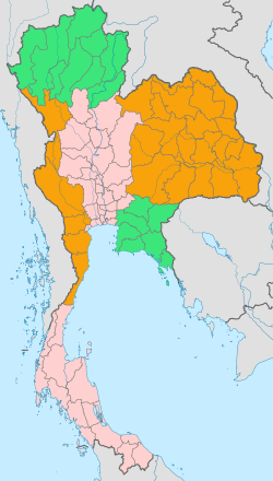
The National Research Council divides Thailand into six geographical regions, based on natural features including landforms and drainage, as well as human cultural patterns.[44] They are:
Although Bangkok geographically is part of the central plain, as the capital and largest city this metropolitan area may be considered in other respects a separate region.[4]
Each of the six geographical regions differs from the others in population, basic resources, natural features, and level of social and economic development.[4] The diversity of the regions is in fact the most pronounced attribute of Thailand's physical setting.[4]
These high mountains are incised by steep river valleys and upland areas that border the central plain.[4] Most rivers, including the Nan, Ping, Wang, and Yom, unite in the lowlands of the lower-north region and the upper-central region. The Ping River and the Nan River unite to form the Chao Phraya River. The northeastern part is drained by rivers flowing into the Mekong basin, like the Kok and Ing. The Thi Lo Su Waterfall in Tak province is claimed to be the tallest and highest waterfall in Thailand.
Traditionally, these natural features made possible several different types of agriculture, including wet-rice farming in the valleys and shifting cultivation in the uplands.[4] The forested mountains also promoted a spirit of regional independence.[4] Forests, including stands of teak and other economically useful hardwoods that once dominated the north and parts of the northeast, had diminished by the 1980s to 130,000km2.[4] In 1961 they covered 56% of the country, but by the mid-1980s forestland had been reduced to less than 30% of Thailand's total area.[4]
The northeast (aka Isan), with its poor soils, is not favoured agriculturally.[4] However, sticky rice, the staple food of the region, which requires flooded, poorly drained paddy fields, thrives and where fields can be flooded from nearby streams, rivers and ponds, often two harvests are possible each year. Cash crops such as sugar cane and manioc are cultivated on a vast scale, and to a lesser extent, rubber. Silk production is an important cottage industry and contributes significantly to the economy.
The region consists mainly of the dry Khorat Plateau which in some parts is extremely flat, and a few low but rugged and rocky hills, the Phu Phan Mountains.[4] The short monsoon season brings heavy flooding in the river valleys.[4] Unlike the more fertile areas of Thailand, the northeast has a long dry season, and much of the land is covered by sparse grasses.[4] Mountains ring the plateau on the west and the south, and the Mekong delineates much of the northern and eastern rim.[4] Some varieties of traditional medicinal herbs, particularly of the Genus Curcuma, family Zingiberaceae, are indigenous to the region.
The "heartland", central Thailand, is a natural self-contained basin often termed "the rice bowl of Asia".[4] The complex irrigation system developed for wet-rice agriculture in this region provided the necessary economic support to sustain the development of the Thai state from the 13th century Sukhothai Kingdom to contemporary Bangkok.[4]
Here the rather flat unchanging landscape facilitated inland water and road transport.[4] The fertile area was able to sustain a dense population, 422 people per square kilometre in 1987, compared with an average of 98 for the country as a whole.[4] The terrain of the region is dominated by the Chao Phraya and its tributaries and by the cultivated paddy fields.[4]
Metropolitan Bangkok, the focal point of trade, transport, and industrial activity, is on the southern edge of the region at the head of the Gulf of Thailand and includes part of the Chao Phraya delta.[4]
Eastern Thailand lies between the Sankamphaeng Range, which forms the border of the northeastern plateau to the north, and the Gulf of Thailand to the south. The western end of the Cardamom Mountains, known in Thailand as Thio Khao Banthat, extends into eastern Thailand. The geography of the region is characterised by short mountain ranges alternating with small basins of short rivers which drain into the Gulf of Thailand.
Fruit is a major component of agriculture in the area, and tourism plays a strong part in the economy. The region's coastal location has helped promote the Eastern Seaboard industrial development, a major factor in the economy of the region.
Thailand's long mountainous border with Myanmar continues south from the north into western Thailand with the Tenasserim Hills, known in Thailand as Thio Khao Tanaosi (เทือกเขาตะนาวศรี). The geography of the western region of Thailand, like the north, is characterised by high mountains and steep river valleys.
Western Thailand hosts much of Thailand's less-disturbed forest areas. Water and minerals are also important natural resources. The region is home to many of the country's major dams, and mining is an important industry in the area.
Southern Thailand, part of a narrow peninsula, is distinctive in climate, terrain, and resources.[4] Its economy is based on tourism, and palm oil and rubber plantations.[citation needed] In Krabi Province, for example, palm plantations occupy 980,000 rai (1,568km2), or 52% of the province's farmland.[50] Other sources of income include coconut plantations, tin mining.[4]
Rolling and mountainous terrain and the absence of large rivers are conspicuous features of the south.[4] North-south mountain barriers and impenetrable tropical forest caused the early isolation and separate political development of this region.[4] The Songkhla Lake is the largest natural lake in Thailand.
Thailand map of Köppen climate classification zonesSeasonal flooding in Thailand and Cambodia.Fires burning across the hills and valleys of Myanmar Thailand, Laos, and Vietnam (labeled with red dots).
Thailand's climate is influenced by seasonal monsoon winds (the southwest and northeast monsoons).[51]:2
The summer season (aka pre–monsoon) runs from mid-February until mid-May and brings warmer weather.[53][51]:3
Rainy
ฤดูฝน
mid-May to mid-October
The rainy season (aka southwest monsoon) is mid-May to mid-October and prevails over most of the country.[53][51]:2 Moist air moves from the Indian Ocean to Thailand, causing abundant rain over most of the country.[51] August and September are the wettest period of the year.[51]:2 This can occasionally lead to floods.[51]:4 In addition to rainfall caused by the southwest monsoon, the Intertropical Convergence Zone (ITCZ) and tropical cyclones also contribute to producing heavy rainfall during the rainy season.[51] Dry spells commonly occur for one to two weeks from June to early-July.[51]:4 This is due to the northward movement of the ITCZ to southern China.[51]:4
Winter
ฤดูหนาว
mid-October to Mid-February
The winter season (aka northeast monsoon) is active from mid-October till mid-February.[53][51] It brings cold and dry air from China over most of Thailand.[51]:2 In southern Thailand, the northeast monsoon brings mild weather and abundant rainfall on the eastern coast of that region.[51]:2 However most of Thailand experiences dry weather and mild temperatures during this season.[51]:2:4 An exception is the southern part of Thailand which receives abundant rainfall, particularly during October to November.[51]:2
Due to their inland location and latitude, the north, northeast, central, and eastern parts of Thailand experience a long period of warm weather.[51]:3 During the hottest time of the year (March to May), temperatures usually reach up to 30°C (86°F) or more, with the exception of coastal areas where sea breezes moderate afternoon temperatures.[51]:3 In some areas (particularly the north and northeast) close to or below 0°C (32°F).[51]:3 Southern Thailand has mild weather year-round, with less diurnal and seasonal variations in temperatures, due to maritime influences.[51]:3
Most of the country receives a mean annual rainfall of 1,200 to 1,600mm (47 to 63in).[51] However, certain areas on the windward sides of mountains such as Ranong Province on the west coast of southern Thailand and eastern parts of Trat Province receive more than 4,500mm (180in) of rainfall per year.[51] The driest areas are the leeward sides of the central valleys and the northernmost portion of south Thailand, where mean annual rainfall is less than 1,200mm (47in).[51]
Most of Thailand (north, northeast, central, and east) has dry weather during the northeast monsoon and abundant rainfall during the southwest monsoon.[51]:4 In the southern parts of Thailand, abundant rainfall occurs in both the northeast and southwest monsoon seasons, with a peak in September for the western coast and a peak in November–January on the eastern coast.[51]:4
Reference: "Saisons et climats 2003" Hachette ISBN2012437990
Bangkok
The capital Bangkok has a tropical savanna climate (Aw) as per the Köppen climate classification. The Asian monsoon system influences the city's three seasons: summer (hot), rainy, and winter (cool). The winter is rarely below 23°C (41°F): circa 23.2°C (73.8°F) in December to 35.7°C (96.3°F) in April. The annual average temperature is 28.9°C (84.0°F).
The summer begins in mid-February and it's usually dry with occasional storms.[54] The rainy season is caused by the southwest monsoon around mid-May. September is the wettest month with around 335.9 millimetres (13.22in) rainfall. The cool northeast monsoon causes the winter season from mid-October till mid-February.
Bangkok's urban heat island causes a temperature increase of 2.5°C (4.5°F) during daytime and 8.0°C (14°F) at night.[55]Bangkok metropolis' highest temperature was 41.0°C (105.8°F) on 7 May 2023.[56] and the lowest 9.9°C (49.8°F) in January 1955.[57]
Climate data for Bangkok Metropolis (1991–2020, extremes 1951–present)
Source 1: NOAA,[58] Thai Meteorological Department (Feb–May record highs, 1951–2022;[59] Nov–Feb record lows, 1951–2021[57]), CNN (May record high),[56] Ogimet (other record highs/lows)[full citation needed]
In 2022, circa 46% is agricultural land. 38.8% is forest.[2] The remaining 15.2% is divided by residential, water (surface, rivers, waterways), roads and wilderness.[2] The exact stats are unavailable.
Pattamawadee Pochanukul, a lecturer from the Faculty of Economics at Thammasat University, estimates that about 59% of all arable land in Thailand belongs to the state. As of 30September2015[update] the Treasury Department owned 176,467 plots of land, consisting of about 9.9 million rai (15,769.6km2).[62] The Ministry of Defence owns about 2.6 million rai (4,230km2) or about 21.2% of total public land. Information from the Office of the National Anti-Corruption Commission (NACC) shows that members of the house of representatives in 2013 owned a total of 35,786 rai of land (about 57.3km2).[63]
Thailand has the world's 64th largest exclusive economic zone (EEZ), with an area of 305,778km2 (118,062mi2).[64][5] It claims an EEZ of 200nmi (370.4km; 230.2mi) from its shores, which has long coastlines with the Andaman Sea and Strait of Malacca to the west and the Gulf of Thailand to the east, although all of its EEZ is limited by maritime boundaries with neighboring countries. Circa 3/4th of the coastline around the Gulf of Thailand is part of Thailand.
Inland fishery
Over 150 fish species have been identified in catches from inland waters. 20 of these are economically important.[32] The most common fish is the carp (represented by Puntius gonionotus, Puntioplites proctosyzron, Cirrhinus jullieni, Osteocheilus hasselti, Labiobarbus lineatus, Morulius chrysophekadion etc).[32] The favorite fish of Thai people are 2 species of Snakehead (fish) called Channa striata and Channa micropeltes.[32] The main catfish species are Clarias batrachus, C. microcephalus, Pangasius sutchi, P. larnooudii, P. siamensis, Kryptopterus pogon and Ompok bimaculatus.[32]Corcia siamensis is the only representative of the clupeidae family.[32]
In 2014, 75% of Thailand's electricity production was fueled by natural gas.[65] Coal-fired power plants produced an additional 20% of the electricity, with the remainder coming from biomass, hydropower, and biogas.[65]
Thailand produces about a third of the oil it consumes. It is the second-largest oil importer in Southeast Asia. Thailand is a major producer of natural gas, with reserves of at least 3 trillion cubic meters. After Indonesia, it is the largest coal producer in Southeast Asia, but it needs to import more coal to meet domestic demand.
Biota
Fauna
The biogeographic realm is part of the Indomalayan realm, spanning the Indochina and Sunda subrealms.[70] According to ONEP (2007), there are 302 recorded mammal species, 982 bird species, 350 reptile species, 137 amphibian species, and 2,820 fish species (720 freshwater fish species[66]).[67] The conservation status of 1,196 of these species was assessed in 2005, and 116 mammal species, 180 bird species, 32 reptile species, 5 amphibian species, and 215 fish species were listed as threatened.[68] Circa 264 mammal species in Thailand are on the IUCN Red List.
The elephant is a representative animal, and white elephants are considered symbols of kingship, have been featured on the national flag, and are considered to be the incarnation of Buddha in Buddhism, which is practiced by the majority of the population.[69] At the beginning of the 20th century, there were approximately 100,000 elephants in captivity, but as of 2023, the wild population had declined to approximately 2,250 and the captive population to approximately 2,400. The central government has taken measures to protect elephants, such as opening conservation facilities and dedicated hospitals.[69] See also elephants in Thailand. Water buffalo and bulls were also used as working animals, but by the 1980s, due to the diversification of transportation methods, they were rarely used as working animals.[70]
Natural hazards: Land subsidence in Bangkok, resulting from the depletion of the water table; droughts (see also 2004 Indian Ocean earthquake and 2011 Thai floods). Thailand is highly exposed to the effects of climate change such as the rising sea levels and extreme weather events.[78]
Drought: Droughts are a persistent feature of Thailand's climate. Droughts appear to be worsening according to the Thai Meteorological Department.[79][80] and drought hazard mapping.[51]
Wildlife populations threatened by illegal hunting
Agriculture impact
The unpredictability of precipitation, temperature changes and many other harmful events will intensify in the future.[81] This means that Thailand will have to face droughts in the middle of the rainy season, which will result in damage to young plants and flooding of rice fields.[81] It is therefore imperative for Thailand to adapt as quickly as possible to these changes to protect its population on the one hand and, if it wishes, to maintain a monopoly on the export of rice and not suffer significant losses.[81] Which would ultimately have a huge impact on the country's economy.[81] Particularly with the fluctuation in the price of rice, due to uncertainties, which prevents farmers from increasing their income.[81]
Thailand shares boundaries with Cambodia, Laos, Malaysia, and Myanmar. The territories of China and Vietnam do not border Thailand, but they are within around 100km distance.
Many parts of Thailand's boundaries follow natural features, such as the Mekong river.[4] Most borders were stabilized and demarcated in the late 19th and early 20th centuries in accordance with treaties forced on Thailand and its neighbors by the British Empire and French Indochina.[4] In some areas, however, exact boundaries, especially along Thailand's eastern borders with Laos and Cambodia, are still disputed.[4]
Cambodia's disputes with Thailand after 1951 arose in part from ill-defined boundaries and changes in France's colonial fortunes.[4] Recently, the most notable case has been a dispute over Preah Vihear submitted to the International Court of Justice, which ruled in favor of Cambodia in 1962.[4] During the years that the Cambodian capital, Phnom Penh, was controlled by the Khmer Rouge regime of Pol Pot (1975 to 1979), the border disputes continued.[4]
Demarcation is complete except for certain Mekong islets. The border is marked by the Mekong: at high water during the rainy season, the centre line of the current is the border, while during low water periods, all islands, mudbanks, sandbanks, and rocks that are revealed belong to Laos.
In contrast to dealings with Cambodia, which attracted international attention, boundary disputes with Malaysia are usually handled more cooperatively.[4] Continuing mineral exploration and fishing, however, are sources of potential conflict.[4] One segment at the mouth of the Golok River remained in dispute with Malaysia as of 2023, along with a section of the continental shelf in the Gulf of Thailand.[82]
Sovereignty over three Andaman Sea islands remains disputed. The standing agreement, negotiated in February 1982, left undetermined the status of Ginga Island (Ko Lam), Ko Kham, and Ko Ki Nok at the mouth of the Kraburi River (Pakchan River). Subsequent negotiations in 1985, 1989, and 1990 made no progress. The two parties have designated the islands as "no man's land". Ongoing tensions in the area resulted in minor clashes in 1998, 2003, and 2013.[83]
12345678910111213141516"Thailand". The World Factbook. Central Intelligence Agency. 29 September 2025. Archived from the original on 5 Nov 2025. Retrieved 5 Nov 2025.
↑Mundus. Wissenschaftliche Verlagsgesellschaft. 1981. p. 65. Retrieved 17 January 2012.
↑"ตารางที่ 2 พี้นที่ป่าไม้ แยกรายจังหวัด พ.ศ.2562"[Table 2 Forest area Separate province year 2019]. Royal Forest Department (in Thai). 2019. Retrieved 6 April 2021, information, Forest statistics Year 2019, Thailand boundary from Department of Provincial Administration in 2013{{cite web}}: CS1 maint: postscript (link)
↑รายงานสถิติจำนวนประชากรและบ้านประจำปี พ.ส.2562[Statistics, population and house statistics for the year 2019]. Registration Office Department of the Interior, Ministry of the Interior. stat.bora.dopa.go.th (in Thai). 31 December 2019. Archived from the original on 14 June 2019. Retrieved 26 February 2020.
↑Dr. Susan L. Woodward (1997–2014). "Tropical Savannas". Biomes of the World. S. L. Woodward. Archived from the original on 19 December 2013. Retrieved 23 February 2014.
12345"The Seasons of Thailand". Sawasdee Thailand. Department of Meteorology. 17 May 2023. Archived from the original on 29 November 2024. Retrieved 5 November 2025.
↑"The Climate of Thailand"(PDF). tmd.go.th. Thailand: Climatological Group, Meteorological Development Bureau, Meteorological Department. January 2012. Archived from the original(PDF) on 1 August 2016. Retrieved 26 September 2012.
This page is based on this Wikipedia article Text is available under the CC BY-SA 4.0 license; additional terms may apply. Images, videos and audio are available under their respective licenses.