Continent | Asia |
---|---|
Region | Southeast Asia |
Coordinates | 1°17′N103°50′E / 1.283°N 103.833°E |
Area | Ranked 175th |
• Total | 734.3 km2 (283.5 sq mi) |
• Land | 98.57% |
• Water | 1.43% |
Coastline | 193 km (120 mi) |
Borders | Land border crossings namely Woodlands Checkpoint and Tuas Checkpoint, various coastal and air checkpoints linking Malaysia and Indonesia, as well as international destinations. |
Highest point | Bukit Timah Hill 164 m (538 ft) |
Lowest point | Indian Ocean, South China Sea 0 m (0 ft) |
Longest river | Kallang River 10 km (6 mi) |
Largest lake | None |
Exclusive economic zone | 1,067 km2 (412 sq mi) |
Singapore is an island city-state and country in maritime Southeast Asia, located at the end of the Malayan Peninsula between Malaysia and Indonesia as well as the Straits of Malacca and the South China Sea. It is heavily compact and urbanised. As of 2023, Singapore has a total land area of 734.3 square kilometres (283.5 sq mi). [1] Singapore is separated from Indonesia by the Singapore Strait and from Malaysia by the Straits of Johor.
Geographically, Singapore comprises its mainland and other islands. The mainland of Singapore measures 50 kilometres (31 mi) from east to west and 27 kilometres (17 mi) from north to south with 193 kilometres (120 mi) of coastline. These figures are based on 2.515 metres (8 ft 3.0 in) High Water Mark cadastral survey boundaries. [2] It has an exclusive economic zone of 1,067 km2 (412 sq mi).
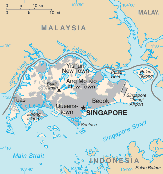
Singapore's main territory looks like a diamond-shaped island, although its territory includes surrounding smaller islands. The farthest outlying island is Pedra Branca. Of Singapore's dozens of smaller islands, Jurong Island, Pulau Tekong, Pulau Ubin and Sentosa are the larger ones. Most of Singapore is no more than 15 meters above sea level.
The highest point of Singapore is Bukit Timah Hill, with a height from the ground of 165 m (538 ft) and made up of igneous rock, granite. Hills and valleys of sedimentary rock dominate the northwest, while the eastern region consists of sandy and flatter land. Singapore has no natural lakes, but reservoirs and water catchment areas have been constructed to store fresh water for Singapore's water supply.
Singapore has reclaimed land with earth obtained from its own hills, the seabed, and neighboring countries. As a result, Singapore's land area has grown from 581.5 km2 in the 1960s to 725.7 km2 today, and will increase slightly more due to the construction of sea polder and barrage to deal with the ever-rising sea level.
Singapore is one-and-a-half degrees north of the equator, lying entirely between the 1st and 2nd parallels. Singapore's climate is classified as tropical rainforest climate (Köppen climate classification Af), with no true distinct seasons. Owing to its geographical location and maritime exposure, its climate is characterised by uniform temperature and pressure, high humidity and abundant rainfall. Therefore, it is almost always warm and wet. The average annual rainfall is around 2,340 mm (92.1 in). The highest 24-hour rainfall figures ever recorded in history were 512.4 mm (20.2 in) (2 December 1978) at Paya Lebar, 467 mm (18.4 in) (1969) and 366 mm (14.4 in) (19 December 2006). [3]
The temperature hovers around a diurnal range of a minimum of 25 °C (77.0 °F) and a maximum of 33 °C (91.4 °F). May is the hottest month of the year in Singapore, followed by June. This is due to light winds and strong sunshine during those months. [4] The highest recorded temperature is 37.0 °C (98.6 °F), which was recorded twice on 17 April 1983 and 13 May 2023. [5] The lowest recorded temperature was 19.0 °C (66.2 °F) on 14 February 1989 at Paya Lebar. [6] Temperature often goes above 33.2 °C (91.8 °F) and can reach 35 °C (95 °F) at times. [7]
Relative humidity has a diurnal range in the high 90s in the early morning to around 60% in the mid-afternoon, but does go below 50% at times. During prolonged heavy rain, relative humidity often reaches 100%. Generally, there is much more rainfall on the western side of the island than on the eastern portion of Singapore, owing to a rain shadow effect.
Thus, the eastern side of Singapore is much drier and slightly hotter than western Singapore. This can cause slight weather disparities from one side of the island to the other. This is significant to note because even a small hill such as Bukit Timah Hill can cause this phenomenon. Despite Singapore's small size, there may be sunshine on one side while there is rain on the other.
Further contrasts that prevent true all-year uniformity are the monsoon seasons which happen twice each year. The first one is the Northeast Monsoon which occurs from mid-November to early March. The second is the Southwest Monsoon season which occurs from June to September. Periods between monsoon seasons receive less rain and wind. During the Northeast Monsoon, northeast winds prevail, sometimes reach 20 km/h (12 mph). There are cloudy conditions in December and January with frequent afternoon showers.
Spells of widespread moderate to heavy rain occur lasting from 1 to 3 days at a stretch. It is relatively dry in February till early March although rainfall still exceeds 120mm. It is also generally windy with wind speeds sometimes reaching 30 to 50 km/h (19 to 31 mph) in the months of January and February. During the Southwest Monsoon season, southeast winds prevail. Isolated to scattered showers occur in the late morning and early afternoon. Early morning "Sumatras" – squall lines that originate over nearby Sumatra – are common.
Climate data for Singapore (1991–2020 normals, extremes 1929–1941 and 1948–present) | |||||||||||||
---|---|---|---|---|---|---|---|---|---|---|---|---|---|
Month | Jan | Feb | Mar | Apr | May | Jun | Jul | Aug | Sep | Oct | Nov | Dec | Year |
Record high °C (°F) | 35.2 (95.4) | 35.2 (95.4) | 36.0 (96.8) | 35.8 (96.4) | 36.5 (97.7) | 35.0 (95.0) | 34.0 (93.2) | 34.2 (93.6) | 34.4 (93.9) | 34.6 (94.3) | 34.4 (93.9) | 33.8 (92.8) | 36.0 (96.8) |
Mean daily maximum °C (°F) | 30.6 (87.1) | 31.5 (88.7) | 32.2 (90.0) | 32.4 (90.3) | 32.3 (90.1) | 31.9 (89.4) | 31.4 (88.5) | 31.4 (88.5) | 31.6 (88.9) | 31.8 (89.2) | 31.2 (88.2) | 30.5 (86.9) | 31.6 (88.9) |
Daily mean °C (°F) | 26.8 (80.2) | 27.3 (81.1) | 27.8 (82.0) | 28.2 (82.8) | 28.6 (83.5) | 28.5 (83.3) | 28.2 (82.8) | 28.1 (82.6) | 28.0 (82.4) | 27.9 (82.2) | 27.2 (81.0) | 26.8 (80.2) | 27.8 (82.0) |
Mean daily minimum °C (°F) | 24.3 (75.7) | 24.6 (76.3) | 24.9 (76.8) | 25.3 (77.5) | 25.7 (78.3) | 25.7 (78.3) | 25.4 (77.7) | 25.3 (77.5) | 25.2 (77.4) | 25.0 (77.0) | 24.6 (76.3) | 24.3 (75.7) | 25.0 (77.0) |
Record low °C (°F) | 19.4 (66.9) | 19.7 (67.5) | 20.2 (68.4) | 20.7 (69.3) | 21.2 (70.2) | 20.8 (69.4) | 19.7 (67.5) | 20.2 (68.4) | 20.7 (69.3) | 20.6 (69.1) | 21.1 (70.0) | 20.6 (69.1) | 19.4 (66.9) |
Average rainfall mm (inches) | 221.6 (8.72) | 105.1 (4.14) | 151.7 (5.97) | 164.3 (6.47) | 164.3 (6.47) | 135.3 (5.33) | 146.6 (5.77) | 146.9 (5.78) | 124.9 (4.92) | 168.3 (6.63) | 252.3 (9.93) | 331.9 (13.07) | 2,113.2 (83.20) |
Average rainy days (≥ 0.2 mm) | 13 | 9 | 12 | 15 | 15 | 13 | 14 | 14 | 13 | 15 | 19 | 19 | 171 |
Average relative humidity (%) | 83.5 | 81.2 | 81.7 | 82.6 | 82.3 | 80.9 | 80.9 | 80.7 | 80.7 | 81.5 | 84.9 | 85.5 | 82.2 |
Mean monthly sunshine hours | 180.4 | 198.6 | 196.6 | 182.4 | 184.8 | 175.4 | 188.5 | 184.6 | 161.4 | 155.0 | 133.2 | 133.1 | 2,074 |
Source 1: National Environment Agency [8] [9] | |||||||||||||
Source 2: NOAA (sun only, 1991–2020) [10] |
Singapore | ||||||||||||||||||||||||||||||||||||||||||||||||||||||||||||
---|---|---|---|---|---|---|---|---|---|---|---|---|---|---|---|---|---|---|---|---|---|---|---|---|---|---|---|---|---|---|---|---|---|---|---|---|---|---|---|---|---|---|---|---|---|---|---|---|---|---|---|---|---|---|---|---|---|---|---|---|
Climate chart (explanation) | ||||||||||||||||||||||||||||||||||||||||||||||||||||||||||||
| ||||||||||||||||||||||||||||||||||||||||||||||||||||||||||||
|
Graphs are unavailable due to technical issues. There is more info on Phabricator and on MediaWiki wiki. |
See or edit raw graph data.
Singapore recognises that climate change in the decades ahead will have major implications for the island-nation. It has taken a three-prong approach to the issue - researching how the nation will be affected in specific details, implementing mitigation measures and adapting to the coming changes. For the research, a Centre for Climate Research Singapore (CCRS) has been established. [12]
The government estimates that $100 billion will need to be spent over a 100-year time frame to address the issue. In the 2020 budget, it has set aside an initial $5 billion towards a Coastline and Flood Protection Fund. [13] For the population, it will provide incentives for owners to convert to electric vehicles (EVs), like rebates on the Additional Registration fees and expanding the EV charging network. By 2040, it expects to phase out petrol and diesel (internal combustion engine) vehicles. The country's transport policy continues to focus on a "car-lite" future with most commuters using public transportation (MRT trains, buses, taxis) instead. [14]
Singapore is the first country in Southeast Asia to levy a carbon tax, at $5 per ton, applicable for its largest carbon-emitting corporations that produce more than 25,000 tons of carbon dioxide per year. [15] To reduce the country's dependence on fossil fuels, it is building one of the world's largest floating solar farm at Tengeh Reservoir in Tuas, with a capacity of 60MW. [16]
Although Singapore does not observe daylight saving time (DST), it follows the UTC+8 time zone, one hour ahead of the typical zone for its geographical location.
Daylight | ||
---|---|---|
February | July | November |
07:16 – 19:20 | 07:05 – 19:16 | 06:46 - 18:50 |
Igneous rocks are found in Bukit Timah and Woodlands and Pulau Ubin island. Granite makes up the bulk of the igneous rock. Gabbro is also found in the area and is found in an area called Little Guilin named for its resemblance to Guilin in Southern China. This area is in Bukit Gombak. Sedimentary rocks are found on the western part of Singapore and is mainly made of sandstone and mudstones. It also includes the southwestern area. Metamorphic rocks are found in the northeastern part of Singapore and also on Pulau Tekong off the east coast of Singapore. The rocks are mainly made up of quartzite and also make up the Sajahat Formation.
Singapore is relatively safe from seismic activity in the region, as the nearest major active faults (Sumatran fault and Sunda megathrust fault) are hundreds of kilometres away in Indonesia. However, the population and buildings are prone to being only very slightly affected by any activity as tremors, which is not uncommon, but generally does not do any harm and is limited to small amounts of swaying or vibration of objects.
In late 2004, several parts of Asia and Africa were struck by the 2004 Indian Ocean earthquake and the resulting tsunami. Singapore was fortunate as it was protected by the Sumatra landmass, which bore the brunt of the tsunami; the effect on Singapore was limited to tremors felt in some of the common high-rise buildings there.
When Singapore was first colonised by the British, the City of Singapore was situated on the southern coast, around the mouth of the Singapore River. This area remains the Central Area of Singapore. The rest of the island was farmland and primary rainforest. However, since the 1960s the government has constructed many new towns in other areas, so that today the island is nearly entirely built-up and urbanised, with only a few exceptions, such as the district of Lim Chu Kang or reclaimed land in the process of being developed.
The country has several subdivisions, mostly used for administrative or statistical purposes. Politically, Singapore is divided into five administrative districts, these are then further subdivided into town councils which usually consists of one or more political constituencies. However, unlike other countries where local government subdivisions are used to cite locations, the same practice is often uncommon in Singapore. Political boundaries fluctuate with every general election and thus, the areas they cover do not necessarily correspond to the local perception of a place. Most geographical regions, districts and neighbourhoods within the city-state are usually overlapping and can sometimes be arbitrarily defined. Planning and census boundaries, called planning areas, have been used by the Urban Redevelopment Authority to define certain districts and neighbourhoods, [17] although these boundaries may not necessarily correspond with the common perception of a certain place. While boundaries for new towns do exist, [18] there have been instances where certain neighbourhoods can be identified separately from the town it is located in. Tiong Bahru for example, is often identified separately from the HDB town it is a part of, Bukit Merah.
As the main government agency responsible for the urban planning of Singapore, the Urban Redevelopment Authority seeks to implement efficient land use and minimise pollution while maintaining convenient transport, which are Singapore's largest concerns because of its situation as a city-state. A Development Guide Plan for each of the 55 planning areas has been released in the process.
In order to reduce traffic congestion, Electronic road pricing (ERP) has been enacted around entrances into the Central Area. The other parts of Singapore are less dense and busy, and are often filled with housing estates such as from the Housing and Development Board (HDB) or condominiums, and commercial districts are less concentrated. However, to reduce strain on the Central Area, several regional centres have been developed, each containing a concentrated commercial district.
Light industry tends to be distributed around the island as industrial estates and located in flats, similar to the HDB, and only allow tenants which produce close to nil pollution, whereas heavy industry tends to be located around Jurong and Jurong Island. A list of such estates can be found here.
There are two connections to the state of Johor, Malaysia. In the north there is a causeway for both rail and road traffic, which connects to the city of Johor Bahru. In the west there is a road bridge (Tuas Second Link), which connects to Johor, for road traffic only. The connections are an important economic link to Malaysia, which can be seen as a hinterland.
The causeway (1,038 m in length) was designed by Coode, Fizmaurice, Wilson and Mitchell of Westminster and constructed by Topham, Jones & Railton Ltd of London. It was started in 1909 as a railway link by Johor State Railway to connect Johor Bahru to Singapore, then the administrative headquarters of British interests in Southeast Asia. Construction of the road section started in 1919 and completed in 1923.
The causeway has caused ecological problems, most notably accumulation of silt in the Johore Strait. This has led to disagreements with Malaysia. Singapore has rejected Malaysia's proposal to replace the causeway with a bridge, and Malaysia has since proposed the idea of what became known as "the crooked half-bridge", descending halfway to link up with the low-level causeway.
Since Singapore lacks natural freshwater rivers and lakes, the primary source of domestic water is rainfall. Demand for fresh water is approximately twice that supplied by rainfall, so Singapore imports much of its fresh water from Malaysia and Indonesia. To lessen its reliance on imports, Singapore has built reservoirs to collect rainwater from both forest catchment and urban catchment run-offs and from recycled water facilities. In addition, Singapore has built three desalination plants on the western coast of Tuas with two more under construction. They are expected to at least meet 30% of Singapore's water demands in 2060. Recent plans to produce NEWater-recycled water from treatment by filtration via reverse osmosis have been very successful as the government has opened up three plants around the island to help meet the demand.
There are more than 300 parks and 4 nature reserves in Singapore. There are also many trees planted, and almost fifty per cent of the country is covered by greenery. Because of this, Singapore is also commonly known as the 'Garden City'. [19]
Singapore remains highly vulnerable to the impact of climate change; in particular, the rising sea levels may pose a major threat to the very survival of the country in the long-term perspective. [20]
Largest towns and planning areas in Singapore | |||||||||
---|---|---|---|---|---|---|---|---|---|
Rank | Name | Region | Pop. | Rank | Name | Region | Pop. | ||
Bedok Tampines | 1 | Bedok | East | 278,270 | 11 | Ang Mo Kio | North-East | 161,000 | Jurong West Sengkang |
2 | Tampines | East | 265,340 | 12 | Bukit Merah | Central | 149,160 | ||
3 | Jurong West | West | 258,240 | 13 | Pasir Ris | East | 145,990 | ||
4 | Sengkang | North-East | 252,730 | 14 | Bukit Panjang | West | 137,020 | ||
5 | Woodlands | North | 252,190 | 15 | Toa Payoh | Central | 128,450 | ||
6 | Hougang | North-East | 226,990 | 16 | Serangoon | North-East | 117,910 | ||
7 | Yishun | North | 222,580 | 17 | Geylang | Central | 109,150 | ||
8 | Choa Chu Kang | West | 189,990 | 18 | Sembawang | North | 108,220 | ||
9 | Punggol | North-East | 185,180 | 19 | Kallang | Central | 100,520 | ||
10 | Bukit Batok | West | 164,560 | 20 | Queenstown | Central | 96,730 |
The geography of Malaysia includes both the physical and the human geography of Malaysia, a Southeast Asian country made up of two major landmasses separated by water—Peninsular Malaysia to the West and East Malaysia to the East—and numerous smaller islands that surround those landmasses. Peninsular Malaysia is on the southernmost part of the Malay Peninsula, south of Thailand, north of Singapore and east of the Indonesian island of Sumatra; East Malaysia comprises most of the northern part of Borneo island, and shares land borders with Brunei to the north and Indonesian Borneo to the south.
Jurong is a major geographical region located at the south-westernmost point of the West Region of Singapore. Although mostly vaguely defined, the region's extent roughly covers the planning areas of Jurong East, Jurong West, Boon Lay, and Pioneer, along with Jurong Island in the Western Islands cluster and the southernmost portions of the Western Water Catchment. Should it be described at its greatest historical extent, the region can also include present-day Bukit Batok and Tuas.
The Malaysia–Singapore Second Link is a bridge connecting Singapore and Johor, Malaysia. In Singapore, it is officially known as the Tuas Second Link. The bridge was built to reduce the traffic congestion at the Johor–Singapore Causeway and was opened to traffic on 2 January 1998. It was officially opened by Singapore's then Prime Minister Goh Chok Tong with Mahathir Mohamad, who was then Prime Minister of Malaysia. The bridge supports a dual-three lane carriageway linking Kampong Ladang at Tanjung Kupang, Johor to Jalan Ahmad Ibrahim at Tuas, Singapore. The total length of the bridge over water is 1.92 kilometres (1.19 mi). The actual distance between both checkpoints is approximately 6 kilometres (3.7 mi). At Malaysian side, the bridge is connected to the Second Link Expressway E3 also known as Linkedua Expressway, which links from Senai North Interchange Exit 253 at North–South Expressway E2, Senai Airport and Taman Perling, Johor Bahru via its extension known as Johor Bahru Parkway E3. In Singapore, the bridge connects to the Ayer Rajah Expressway.
Bukit Batok, often abbreviated as Bt Batok, is a planning area and matured residential town located along the eastern boundary of the West Region of Singapore. Bukit Batok statistically ranks in as the 25th largest, the 12th most populous and the 11th most densely populated planning area in the Republic. It is bordered by six other planning areas - Choa Chu Kang to the North, northeast and northwest, Cashew to the northeast and east, Clementi to the south, Bukit Timah to the southeast, Jurong East to the southwest and Tengah to the west.
The Pan Island Expressway is the oldest and longest expressway in Singapore. It is also Singapore's longest road. The expressway runs from the East Coast Parkway near Changi Airport in the east to Tuas in the west and has a total length of 42.8 kilometres (26.6 mi).
Boon Lay is a neighbourhood located in the town of Jurong West in the West Region of Singapore. Its borders very roughly correspond to the URA subzone of Boon Lay Place, situated within the Jurong West Planning Area.
Rail transport in Singapore mainly consists of a passenger urban rail transit system spanning the entire city-state: a rapid transit system collectively known as the Mass Rapid Transit (MRT) system operated by the two biggest public transport operators SMRT Trains and SBS Transit, as well as several Light Rail Transit (LRT) rubber-tyred automated guideway transit lines also operated by both companies. In addition, local specialised light rail lines are in operation in places such as the Singapore Changi Airport and Sentosa.
The Johor–Singapore Causeway is a 1.056-kilometre (0.66 mi) causeway consisting of a combined railway and motorway bridge that links the city of Johor Bahru in Malaysia across the Straits of Johor to the district and town of Woodlands in Singapore. It was the only land connection between the two from 1928 until 1998, when the Tuas Second Link opened.
The Malaysia–Singapore border is an international maritime border between the Southeast Asian countries of Malaysia, which lies to the north of the border, and Singapore to the south. The boundary is formed by straight lines between maritime geographical coordinates running along or near the deepest channel of the Straits of Johor.
Singapore has about 65 species of mammals, 390 species of birds, 110 species of reptiles, 30 species of amphibians, more than 300 butterfly species, 127 dragonfly species, and over 2,000 recorded species of marine wildlife.
The Western Water Catchment is a planning area located in the West Region of Singapore. The planning area borders Tuas and Pioneer to its south, Sungei Kadut, Choa Chu Kang and Tengah to its east, Jurong West to its southeast, Lim Chu Kang to its north and the Straits of Johor to its west. It is the largest planning area by land area, covering nearly a tenth of Singapore Island. It is also one of the two main water catchments in Singapore, the other being Central Water Catchment.
The Battle of Kranji was the second stage of the Empire of Japan's plan for the invasion of Singapore during the Second World War. On 9 February 1942 the Imperial Japanese Army assaulted the north-western front of Singapore, capital of the Straits Settlements.
The Western Islands is a planning area located within the West Region of Singapore. It comprises a collection of islands located in the south-western waters of Singapore, namely Jurong Island, Pulau Bukom and Sudong Islands.
The following outline is provided as an overview and topical guide to Singapore:
Pulau Merambong, formerly known as Pulo Ular, is an uninhabited island on the Straits of Johor. The island is dominated by mangrove swamp. It is located just 1 kilometre off the coast from Tuas, Singapore. Administratively, it is placed under the Pontian District, Johor, Malaysia.
Malaysia–Singapore relations refers to the bilateral relations between Malaysia and the Republic of Singapore, after the expulsion of Singapore from Malaysia in 1965. Singapore has a high commission in Kuala Lumpur and a consulate general in Johor Bahru, while Malaysia has a high commission in Singapore. Both countries are full members of the Commonwealth of Nations and ASEAN.
Occasionally, some parts of Singapore are inundated by floods, usually in the form of flash floods that came about due to intense rainfall over a short period of time. Floods in Singapore are much less severe than floods in other countries, often only lasting a few hours before dissipating on its own.
The Aur Island is an island in Mersing District, Johor, Malaysia. It lies about 76 kilometres (47 mi) east of Mersing Town and is part of the Johor Marine Park. Its corals, lagoons and offshore pools make it a tourist attraction. It has for many years also been a frequent stopover point for fishermen.
Library resources about Geography of Singapore |