This article is about the city centre of Singapore. For its urban core as well as an explanation about the term, "Central Business District", see Downtown Core. For other uses, see Central.
Singapore's modern history began in this area, when British colonial official Stamford Raffles and representatives of the British East India Company landed along the banks of the Singapore River in 1819 to set up a free port of trade between Europe and Asia. As the old harbour grew along the mouth of the river bank, the historical city naturally expanded around it, creating what is now the Central Area. As the financial heart of Singapore, the Downtown Core also houses the headquarters and offices of numerous major corporations, both local and international, as well as the Singapore Exchange (SGX). As the country's de factocapital, it is also home to many governmental institutions, most notably the seat of Parliament and the Supreme Court.[5]
The Central Area surrounds the banks of the Singapore River and Marina Bay where the first settlements on the island were established shortly after the arrival of Raffles in 1819. Surrounding the Central Area is the rest of the Central Region. The Central Area shares boundaries with the planning areas of Novena to the north, Kallang to the north and north-east, Tanglin to the north-west and west, Bukit Merah to the south-west and Marine Parade to the east. The south-easternmost limits of the city is enclosed by Marina Barrage, where the mouth of Marina Bay meets the Singapore Strait.
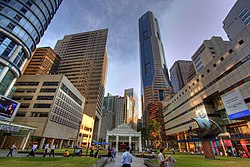
The Central Area is among the most densely developed parts of Singapore. It represents the historical core of the city, tracing its origins to the Jackson Plan of the 1820s following the 1819 Singapore Treaty that marked the beginning of modern-day Singapore. As part of the Straits Settlements, districts within the Central Area functioned as centres of trade and commerce, particularly the Singapore River area. Other districts such as Rochor, Newton, River Valley and Outram also maintain strong commercial activity but generally feature fewer skyscrapers and a larger proportion of residential development. These areas include schools, condominiums and public Housing Development Board (HDB) flats, typically commanding higher prices and longer minimum occupation periods due to their status as being located in "prime areas".[6] Much of the land around Telok Ayer Street, which today contains a high concentration of commercial skyscrapers, was created through land reclamation carried out over the last century. These include nearby landmarks such as Lau Pa Sat, which was founded as a waterfront market that used to face the Singapore Strait.[7]
Parts of the Central Area also reflected historical social and community functions. For example, the shophouses on Ann Siang Hill were historically used as clan houses by various Chinese associations in the Chinatown area. Following World War II, acute housing shortages led to the expansion of public housing developments by the Singapore Improvement Trust (SIT) and later the HDB after 1960 in surrounding areas.[8] The Central Area was also been the site of significant historical events, including the MacDonald House bombing during the Konfrontasi in 1965. The attack on the building at Orchard Road resulted in three deaths and injured at least 33 people.[9]
Since independence
From the 1970s, the Government of Singapore and the Urban Redevelopment Authority (URA) undertook extensive land reclamation projects at Marina Bay to accommodate the continued growth of the Central Area. These reclaimed areas were planned as Marina East, Marina South and Straits View, with major commercial and residential developments progressively completed from the 1990s. Today, the Central Area houses the headquarters of numerous multinational companies (MNCs). Singapore's tallest buildings are concentrated around Raffles Place and Shenton Way and are generally subject to a height limit of 280m (920ft) pending the decommissioning of Paya Lebar Airbase in the 2030s. Exceptions include Guoco Tower, which reaches 290m (950ft), and Skywaters Residences, which is expected to become the country's first supertall skyscraper at 305m (1,001ft) upon its completion in 2028.[10]
Armenian Church, which was completed in 1835 and is the oldest surviving Christian church in Singapore. Designated as a national monument in 1973.[13]
Mosques
Sultan Mosque, which was first constructed in 1826. It was rebuilt into its current and larger structure in 1932 and designated as a national monument in 1975. It is the country's de facto national mosque, holding great significance to the local Muslim community.[14]
Synagogues
Maghain Aboth Synagogue, which was first constructed in 1878. It is the main place of worship for the Jewish community in Singapore and serves as the unofficial centre of Jewish activity in Singapore. Designated as a national monument in 1998.[15]
38 Oxley Road, located at the road of its namesake. It was the residence of the first prime minister of Singapore, Lee Kuan Yew, from the 1940s until his death in 2015. Became a centre of dispute between his children over its fate after his death. Designated as a national monument in 2025.[16]
CHIJMES, located at Victoria Street, was originally a Catholic convent when it was founded in 1854. In the 1990s, it was converted into a modern dining area with restaurants. The original structure was well preserved and the chapel is still present. The restaurants reside in the old structures of the convent. The chapel as well as the Caldwell House within the convent was designated as national monuments in 1990.[17]
Public buses at Orchard Road, a tourist district in the Central AreaThomson–East Coast Line platforms at the triple-interchange Marina Bay station
For more than a century, there has been a high volume of traffic entering the modern-day Central Area because of its role as the financial core of Singapore, which has resulted in a dense concentration of commercial developments. To manage congestion in the Central Area, the government has introduced a range of measures. These include the installation of Electronic Road Pricing (ERP) gantries, whose operating hours and charges are regularly adjusted to reflect prevailing traffic conditions.[20] The North–South Corridor (NSE) is also expected to ease traffic flows from the northern parts of Singapore into the Central Area upon its completion in 2029.[21]
This page is based on this Wikipedia article Text is available under the CC BY-SA 4.0 license; additional terms may apply. Images, videos and audio are available under their respective licenses.


