Marina Bay, Singapore

Last updated

Marina Bay
Name transcription(s)
   Chinese 滨海湾
   Pinyin bīn hăi wān
   Malay Teluk Marina
   Tamil மரீனா விரிகுடா
Singapore skyline at sunset viewed from Gardens by the Bay East - 20120426.jpg
Marina Bay at sunset
Singapore location map (main island).svg
Red pog.svg
Marina Bay
Location of Marina Bay within Singapore
Coordinates: 1°17′04″N103°51′21″E / 1.28444°N 103.85583°E / 1.28444; 103.85583
CountryFlag of Singapore.svg  Singapore
Government
  Members of Parliament Jalan Besar GRC

Marina Bay is a bay located in the Central Area of Singapore, surrounded by the perimeter of four other planning areas, the Downtown Core, Marina East, Marina South and Straits View. The area surrounding the bay itself, also called Marina Bay, is a 360 hectare extension to the adjacent Central Business District. It is also the new downtown of Singapore, built on Singapore's reclaimed land. [1]

Contents

Buildings include Gardens by the Bay, the Marina Bay Sands, Marina Bay Financial Centre, Asia Square, The Sail @ Marina Bay and Marina One integrated mixed-use developments. It is one of the key focus areas by the Urban Redevelopment Authority. Marina Bay is envisioned by the URA as a work-live-play vibrant 24-hour CBD.

Master Plan

The Urban Redevelopment Authority (URA) Master Plan for Marina Bay aims to encourage a mix of uses for this area, including commercial, residential, hotel and entertainment.

History

Marina Bay at night Marina Bay Sands, Singapore, at night - 201208.jpg
Marina Bay at night

In 1969, land reclamation work to create 360 hectares of prime waterfront site began at Marina Bay. The reclaimed land forms what is today the Marina Centre and Marina South areas, and the reclamation work was completed in 1992. [2] [3] [4] In the reclamation process, Inner/Outer Basins (anchorage area for commercial and naval vessels), Telok Ayer Basin (now site of Asia Square Tower 1 and 2) and Inner Roads was removed from the map by reclaiming land, while the Singapore River's mouth now flows into the bay instead of directly into the sea.

The long term visions for the Marina Bay area were first articulated in the 1983 Master Plan by the Urban Redevelopment Authority (URA), with the waterfront areas being deliberately kept open to the public. [2] In 1988, the draft plan for Marina Bay was presented to the public in a two-week exhibition where it set out the objectives for the development, among which are optimising the waterfront location and creating a distinctive image with international landmarks that could become a focal point for the city. [5]

The URA Master Plan for Marina Bay aims to encourage a mix of uses for this area, including commercial, residential, hotel and entertainment and to turn it into a work-live-play vibrant 24-hour CBD. In 2005, the Urban Redevelopment Authority spent $400,000 on a branding exercise to name the Marina Bay area in order to sell the new major developments in the area, only to settle with the original name "Marina Bay". [6] [7]

The Singapore government also spent $35 million to complete the 3.5 km Waterfront Promenade around Marina Bay. [8] It includes a new eco-friendly visitor centre and the Helix Bridge linking Bayfront to Marina Centre where the Youth Olympic Park is located. The Promontory @ Marina Bay (formerly Central Promontory Site) will be used as an interim event and public space used for activities such as theatres and carnivals. [9]

In 2008, Marina Barrage was built, converting the basin into a freshwater Marina Reservoir.

Events at Marina Bay

Marina Bay viewed from the Singapore Flyer at sunset 1 singapore flyer view 2012.jpg
Marina Bay viewed from the Singapore Flyer at sunset

The Formula One Singapore Grand Prix has taken place annually since 2008 (with the exception of the 2020 and 2021 seasons) on a street circuit adjacent to Marina Bay. [10] Since its construction in 2007, The Float@Marina Bay has hosted events such as the National Day Parade, New Year's Eve Countdown [11] and Singapore Fireworks Celebrations, and also serves as a spectator stand for the Singapore Grand Prix. Furthermore, it also played host to the Opening and Closing Ceremonies of the inaugural 2010 Summer Youth Olympics. [12]

The area also hosts the annual i Light Marina Bay, a sustainable light art festival.

The event space next to Marina Bay Sands, known as The Lawn, hosted the first overseas and Singapore edition of ArtBox Bangkok on two separate weekends, 14–16 April and 21–23 April 2017. [13] [14]

Marina Promontory 300522 Marina Promontory Panorama 300522.jpg
Marina Promontory 300522

Infrastructure

The Singapore government pumped nearly S$2 billion (about US$1.2 billion) to build the infrastructural base for Marina Bay, which includes the Marina Barrage, increased connectivity to the MRT, and the new Marina Promenade and Helix Bridge.[ citation needed ]

Common Services Tunnel

The Common Services Tunnel is a development of the Marina Bay area in Singapore. It is said to be the second of its kind in Asia after Japan. This utility tunnel houses telecom cables, power lines, water pipes as well as provision for pneumatic refuse collection pipes. [15] The 1.4-kilometre (4,600 ft) phase one of the tunnel has cost about S$81 million (about US$51 million) while 1.6-kilometre (5,200 ft) phase two, cost around S$137 million (about US$86 million).

District cooling

SP Group's subsidiary, Singapore District Cooling, started operating Singapore’s first district cooling plant, supplying chilled water supplies to One Raffles Quay in May 2006. [16] A second district cooling plant was commissioned in May 2010, [16] which will supply chilled water for the air-conditioning of buildings in the area through pipes housed within the Common Services Tunnel, according to the report. Built at a cost of some S$110 million (about US$69 million), the second district cooling plant will be able to serve 1.25 million square metres of gross floor area and free up space which should be used for building chiller plants and cooling towers for separate buildings. The second district cooling plant started operations on 3 March 2016. [17]

Water management

In 2004, the Public Utilities Board announced plans to construct a new downtown reservoir by damming the Marina Channel. This barrage was completed in 2008. Known as the Marina Barrage, it turned Marina Bay and the Kallang Basin into a confined freshwater reservoir with limited access to marine transportation to regulate the water quality. The new reservoir provides another source of drinking water for Singapore, as well as a stable water level for a variety of water activities and events. The barrage also prevents flooding in the Chinatown area.

Transport

There are currently eight rail stations: City Hall, Raffles Place, Marina Bay, Bayfront, Downtown, Telok Ayer, Esplanade and Promenade serving Marina Bay. As the plan set out, by 2020, the 360 hectares of Marina Bay boasts a comprehensive transport network as Singapore's most rail-connected district. [18] The first three new MRT lines (Circle line, Downtown line) opened between 2012 and 2013. By 2018, the Marina Bay district had more than six MRT stations, all no more than five minutes of each other. The Thomson–East Coast MRT line created better connections within Marina South, opened in 2022. A pedestrian network links developments and MRT stations. [19] Within greater Marina Bay, water taxis will even double up as an alternative mode of transport.

Key developments

In Marina Bay

Other places of interest

See also

Related Research Articles

<span class="mw-page-title-main">Circle MRT line</span> Mass Rapid Transit line in Singapore

The Circle Line (CCL) is a medium-capacity Mass Rapid Transit line in Singapore. It runs in a loop from Dhoby Ghaut station in the city-centre to HarbourFront station in the south via Bishan station in the centre of the country. It also has a branch to Marina Bay station from Promenade station, which will be extended to HarbourFront station from 2026 to form a complete loop. Coloured orange on the rail map, the fully-underground line is approximately 35.5 kilometres (22.1 mi) long with 30 stations. Travelling from one end of the line to the other takes about an hour.

<span class="mw-page-title-main">Kallang</span> Planning Area and HDB Town in Central Region ----, Singapore

Kallang is a planning area and residential zone located in the Central Region of Singapore.

<span class="mw-page-title-main">Marina Bay MRT station</span> Mass Rapid Transit station in Singapore

Marina Bay MRT station is an underground Mass Rapid Transit (MRT) interchange station on the North South (NSL), Circle (CCL) and Thomson–East Coast (TEL) lines in Singapore. Located in the Downtown Core district near Marina Bay, the station serves the Marina One Residences, Marina Bay Suites and the Marina Bay Financial Centre.

<span class="mw-page-title-main">Singapore River</span> River in Singapore

The Singapore River is a river that flows parallel to Alexandra Road and feeds into the Marina Reservoir in the southern part of Singapore. The immediate upper watershed of the Singapore River is known as the Singapore River Planning Area, although the western part of the watershed is classified under the River Valley planning area.

<span class="mw-page-title-main">Promenade MRT station</span> Mass Rapid Transit station in Singapore

Promenade MRT station is an underground Mass Rapid Transit (MRT) interchange station on the Downtown (DTL) and Circle (CCL) lines in Downtown Core, Singapore. Located underneath Temasek Avenue and adjacent to Millenia Tower, the station serves several key attractions and locations such as Suntec City and the Marina Promenade, which the station is named after. The station is at the junction of the Dhoby Ghaut and Marina Bay branches of the CCL.

<span class="mw-page-title-main">Bayfront MRT station</span> Mass Rapid Transit station in Singapore

Bayfront MRT station is an underground Mass Rapid Transit (MRT) interchange station on the Downtown line (DTL) and Circle line (CCL). Located in the Downtown Core of Singapore, the station is underneath Bayfront Avenue and serves the main tourist attractions of Marina Bay Sands and Gardens by the Bay.

<span class="mw-page-title-main">Marina South</span> Planning Area in Central ----, Singapore

Marina South is a planning area located within the Central Area of the Central Region of Singapore. It is largely home to Gardens by the Bay as well as the Marina Barrage. The name has also been used to refer to the larger peninsula the planning area is situated on, which encompasses the planning areas of Straits View and a portion of the Downtown Core.
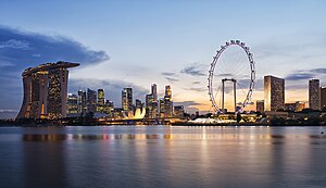
<span class="mw-page-title-main">Gardens by the Bay</span> Nature park in Singapore

The Gardens by the Bay is a nature park spanning 101 hectares in the Central Region of Singapore, adjacent to the Marina Reservoir. The park consists of three waterfront gardens: Bay South Garden, Bay East Garden and Bay Central Garden. The largest of the gardens is the Bay South Garden at 54 hectares designed by Grant Associates. Its Flower Dome is the largest glass greenhouse in the world.

<span class="mw-page-title-main">The Sail @ Marina Bay</span> Residential in Downtown Core, Singapore

The Sail @ Marina Bay is a waterfront lifestyle condominium located in the Marina Bay area in Singapore. It was completed in 2008. The first tenants have moved into Central Park Tower in July 2008. Residents moved into Marina Bay Tower a few weeks later. The structure of The Sail is 245 m (804 ft) with 70 storeys and is one of Singapore's tallest condominia/apartment buildings. This development offers panoramic city view of Marina Bay and the sea. It is close to some of Singapore's famous landmarks such as Suntec City, Marina Bay Sands, Esplanade, Telok Ayer Market and the Singapore River. The Downtown MRT station is built a few meters to the West of the building. The building was erected on reclaimed land, and the Central Linear Park is built on the South Side next to the building.

<span class="mw-page-title-main">Collyer Quay</span> Road in Singapore

Collyer Quay is a road in Downtown Core, Singapore that starts after Fullerton Road and ends at the junction of Raffles Quay, Finlayson Green and Marina Boulevard. The road houses several landmarks namely, Clifford Pier, Change Alley, Hitachi Tower, Ocean Towers and Ocean Financial Centre.

<span class="mw-page-title-main">Future developments in Singapore</span>

This article shows the notable future developments in Singapore. Most of them are currently under construction with most to be completed within the next five years.

<span class="mw-page-title-main">Museum Planning Area</span> Planning Area in Central Region ----, Singapore

The Museum Planning Area is a planning area located in the Central Area of the Central Region of Singapore. The area plays a "bridging role" between the Orchard area and the Downtown Core, which necessitates proper transport networks for vehicles, pedestrians and public transport. Due to the sheer size of green areas in the district, the Urban Redevelopment Authority (URA) has designated it a 'green lung' in the Central Area. However, the Museum Planning Area is also home to cultural and commercial activities. Around 65% of the area is available for future development, making it a hotbed for new infrastructure and buildings.

<span class="mw-page-title-main">The Fullerton Hotel Singapore</span> Hotel in Singapore

The Fullerton Hotel Singapore is a five-star luxury hotel located near the mouth of the Singapore River, in the Downtown Core of the Central Area, Singapore. It was originally known as the Fullerton Building, and also as the General Post Office Building. The address is 1 Fullerton Square. The Fullerton Building was named after Robert Fullerton, the first Governor of the Straits Settlements (1826–1829). Commissioned in 1924 as part of the British colony's centennial celebrations, the building was designed as an office building by Major P.H. Keys of Keys & Dowdeswell, a Shanghai firm of architects, which won the project through an architectural design competition. The architectural firm also designed the Capitol Theatre, its adjoined Capitol Building and the Singapore General Hospital. In 2015, it was designated as a national monument of Singapore.

<span class="mw-page-title-main">Marina Promenade, Singapore</span>

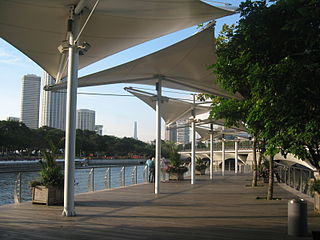
Marina Promenade is a park in Singapore that links Kallang Riverside Park in the north to Esplanade - Theatres on the Bay in the south. The entire park is situated on the western bank of the Kallang Basin and Marina Channel, along Republic Avenue and Republic Boulevard. Landmarks along the park include the Merdeka Bridge, the Benjamin Sheares Bridge, the Singapore Flyer and the Helix Bridge.

<span class="mw-page-title-main">Jurong Lake District</span> Business district in Singapore

Jurong Lake District (JLD) is a district of Singapore, planned as part of Urban Redevelopment Authority (URA)’s decentralisation efforts to bring more quality jobs, amenities, and recreational options closer to homes. The plans for the district have continued to evolve since the blueprint was first unveiled in the URA Master Plan 2008. It consists of three precincts, namely Jurong Gateway, Lakeside and Lakeside Gateway. It is 472 hectares (4,720,000 m2) in size and served by two major expressways and three MRT stations. It will be the Singapore's next central business district. In June 2023, a white site 6.5 hectares (ha) in size was released for sale to kick-start development of the largest commercial district outside Singapore’s city centre.

<span class="mw-page-title-main">Merlion Park</span> Landmark in downtown Singapore

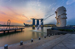
Merlion Park is a famous Singapore landmark and a major tourist attraction, located at One Fullerton, Singapore, near the Central Business District (CBD). The Merlion is a mythical creature with a lion's head and the body of a fish that is widely used as a mascot and national personification of Singapore. Two Merlion statues are located at the park. The original Merlion structure measures 8.6 meters tall and spouts water from its mouth. It has subsequently been joined by a Merlion cub, which is located near the original statue and measures just 2 metres tall.

<span class="mw-page-title-main">Marina One</span> Mixed-use development in Marina South, Singapore

Marina One is a mixed-use development bounded by Marina Way and Straits View in Marina South located within the Downtown Core of the city-state of Singapore.

<span class="mw-page-title-main">Crawford, Singapore</span> Subzone of Kallang Planning Area in Central Region, Singapore

Crawford is a subzone within the planning area of Kallang, Singapore, as defined by the Urban Redevelopment Authority (URA). Its perimeter is made up of Rochor River and Rochor Canal in the north; Crawford Street, Nicoll Highway, Kallang Basin and Marina Channel in the east; East Coast Parkway (ECP) in the south; as well as Ophir Road, Beach Road and Jalan Sultan in the west.

<span class="mw-page-title-main">Straits View</span> Planning Area in Central ----, Singapore

Straits View is a planning area located in the Central Area of the Central Region of Singapore. The area is currently relatively undeveloped, with fewer commercial developments compared to the adjacent Downtown Core.

<span class="mw-page-title-main">Waterboat House Garden</span>

Waterboat House Garden is a small park located near the mouth of the Singapore River, near the Central Business District (CBD) in Singapore. The park was once the original site of the former Merlion Park where the two iconic statues of the Merlion and its miniature form were originally located.

References

  1. "Vision". Marina Bay Singapore 2014. Archived from the original on 4 September 2015. Retrieved 19 March 2014.
  2. 1 2 June Gwee, ed. (2013). Case Studies in Public Governance: Building Institutions in Singapore. Taylor & Francis Ebooks. ISBN   9781136447075.
  3. Ching Tuan Yee and Benjamin Ng. "Marina Bay: The Shape of Things to Come". Civil Service College. Archived from the original on 13 March 2013. Retrieved 26 October 2015.
  4. Collin Anderson (2016). DP Architects on Marina Bay: Designing for Reclaimed Lands. Oro Editions. ISBN   9781941806975. Archived from the original on 11 March 2023. Retrieved 3 October 2020.
  5. Tan Chung Hong (1991). "Planning for the Development of Singapore's Urban Waterfront". In Lin Sien Chia, L. M. Chou (ed.). Urban Coastal Area Management: The Experience of Singapore (PDF). International Specialized Book Services. pp. 54–56. ISBN   9789711022877. Archived (PDF) from the original on 22 December 2015. Retrieved 26 October 2015.
  6. "Singapore spends $400,000 to rename Marina Bay... Marina Bay". Agence France-Presse. 22 July 2005.
  7. "Compass Point renamed twice: Other names in Singapore that drew flak". The Straits Times. 23 December 2015. Archived from the original on 9 January 2019. Retrieved 23 October 2017.
  8. "$35m for Marina Bay waterfront promenade". Asiaone. 19 September 2008. Archived from the original on 21 September 2008. Retrieved 3 June 2010.
  9. "Downtown @ Marina Bay". URA. http://www.ura.gov.sg/cudd/cawebsite/downtown-map.htm Archived 14 May 2011 at the Wayback Machine Retrieved 2010-07-08.
  10. "Singapore to host F1 Grand Prix next year". Channel NewsAsia. 11 May 2006. Archived from the original on 10 October 2012. Retrieved 11 May 2007.
  11. "Marina Bay Singapore Countdown". Archived from the original on 19 February 2018. Retrieved 19 February 2018.
  12. "Marina Bay Floating Stadium". Archived from the original on 9 January 2010. Retrieved 14 July 2010.
  13. "What to expect at Artbox Singapore: the first overseas edition of Bangkok's famous market". Coconuts Singapore. Archived from the original on 22 April 2017. Retrieved 21 April 2017.
  14. "Attention hipsters: Artbox Bangkok is coming to Singapore". AsiaOne. Archived from the original on 22 April 2017. Retrieved 21 April 2017.
  15. "Parliament Briefs : Common Services Tunnels Bill passed". Archived from the original on 19 January 2019. Retrieved 17 January 2019.
  16. 1 2 "Cooling & Heating". SP Group. Archived from the original on 3 September 2018. Retrieved 14 August 2019.
  17. "World's biggest underground district cooling network now at Marina Bay". Archived from the original on 14 August 2019. Retrieved 14 August 2019.
  18. "5 MRT lines to Marina Bay". The Straits Times. 24 May 2010. Archived from the original on 28 October 2010. Retrieved 3 June 2010.
  19. "Seamless Connectivity". Marina Bay Singapore. 2008. http://www.marina-bay.sg/connectivity.html Archived 28 January 2010 at the Wayback Machine . Retrieved 2010-06-03.