Museum | |
---|---|
Other transcription(s) | |
• Chinese | 博物馆(Simplified) 博物館(Traditional) Bówùguǎn(Pinyin) Phok-bu̍t-koán(Hokkien POJ) |
• Malay | Muzium(Rumi) موزيوم(Jawi) |
• Tamil | அருங்காட்சியகம் Aruṅkāṭciyakam(Transliteration) |
From top left to right: National Museum of Singapore, Peranakan Museum, Singapore Art Museum, Aerial view of Bras Basah, Raffles Terrace in Fort Canning Park, Istana Park, The Luxe, The Cathay and SOTA at night | |
![]() Location in Central Region | |
Coordinates: 1°17′47.8″N103°50′54.6″E / 1.296611°N 103.848500°E | |
Country | ![]() |
Region | Central Region |
CDC | |
Town council |
|
Constituency | |
DGP exhibited |
|
PA incorporated |
|
Government | |
• Mayor | Central Singapore CDC |
• Members of Parliament | Tanjong Pagar GRC Jalan Besar GRC |
Area | |
• Total | 0.83 km2 (0.32 sq mi) |
• Rank | 54th |
Population | |
• Total | 760 |
• Rank | 39th |
• Density | 920/km2 (2,400/sq mi) |
• Rank | 36th |
Demonym | Official
|
Postal district | 09 |
The Museum Planning Area is a planning area located in the Central Area of the Central Region of Singapore. The area plays a "bridging role" between the Orchard area and the Downtown Core, which necessitates proper transport networks for vehicles, pedestrians and public transport. Due to the sheer size of green areas in the district, the Urban Redevelopment Authority (URA) has designated it a 'green lung' in the Central Area. However, the Museum Planning Area is also home to cultural and commercial activities. Around 65% of the area is available for future development, making it a hotbed for new infrastructure and buildings.
Museum planning area is bounded by the planning areas of Newton and Rochor to the north, the Downtown Core to the southeast, Singapore River to the south, River Valley to the west and Orchard to the northwest. It is divided itself into three subzones, Bras Basah, Dhoby Ghaut and Fort Canning, home to Fort Canning Hill.
Ten national monuments are located within the Museum Planning Area, namely the Armenian Church, the Cathedral of the Good Shepherd, Cathay Building (now The Cathay), the Central Fire Station, the House of Tan Yeok Nee, the MacDonald House, the Old Tao Nan School (Peranakan Museum), the National Museum of Singapore, the Old Hill Street Police Station and the Singapore Art Museum/Former Saint Joseph's Institution. The area is home to significant events such as the Battle of Singapore and MacDonald House bombing.
Other historical sites include:
The Museum Planning Area is bordered by Rochor to the northeast, the Downtown Core to the southeast, the Singapore River Area to the southwest, River Valley to the west and Newton and Orchard to the northwest. The area is roughly bounded by Hill Street, River Valley Road, Clemenceau Avenue and Bras Basah Road. It is the smallest urban planning area, with an area of 83 hectares.
Parks and open spaces take up a third of the area of the Museum Planning Area, and include Fort Canning, Istana Park and Bras Basah Park, which can be used for recreational purposes. Collectively, these places will form the so-called 'green lung' of the Central Area. Terraces have been proposed to allow for "a more prominent and convenient access" to the Fort Canning area.
The Museum Planning Area is Singapore's "institutional hub", with 11% of land set aside for institutional use and reserve sites to be safeguarded for future institutions. The Registry of Marriages and the sprawling Singapore Management University campus are located in the area.
The many museums in the area, which give the Museum District its name, include the Singapore Art Museum, the National Archives of Singapore, the Children's Museum (formerly the Singapore Philatelic Museum), the Peranakan Museum, the Civil Defence Heritage Gallery (at the site of the Central Fire Station), National Heritage Gallery and the Armenian Heritage Gallery are all here. The National Library, the flagship library of the National Library Board, is also located here. The National Gallery, National Museum of Singapore and the Asian Civilisations Museum are in the neighbouring City Hall, Downtown Core planning area.
The arts scene is vibrant in the area, with The Substation, the Singapore Calligraphy Centre, the YMS Arts Centre and the Singapore Dance Ensemble all located within its boundaries. All the major arts schools in Singapore are also located in Bras Basah: the first pre-tertiary arts school, School of the Arts (SOTA), and also the two institutions that form the University of the Arts: LASALLE College of the Arts and Nanyang Academy of Fine Arts (NAFA). Two buildings here, both designed by local firm WOHA, have also been awarded at the World Architecture Festival: SOTA, in 2010 in the learning category, and Bras Basah MRT station, a Mass Rapid Transit (MRT) station on the Circle line (CCL), in 2009 in the transport category.
Scattered within the area and in neighbouring areas are places of worship such as churches, mosques, Hindu temples and synagogues. Like Telok Ayer Street, it also features them in close proximity to each other: along Waterloo Street and its preluding path there stand the Buddhist Kwan Im Thong Hood Cho Temple, the Hindu Sri Krishnan Temple, the Jewish Maghain Aboth synagogue and the Catholic Church of Saints Peter & Paul. The oldest surviving church in Singapore, the Armenian Church of St. Gregory the Illuminator (est. 1835) and the Bible House are present in the Museum planning area. The second-oldest surviving church, St. Andrew's Cathedral (est. 1836), is in the neighbouring City Hall, Downtown Core planning area.
Despite its prime location, residential projects were only allocated 1% of the land area, and the Museum Planning Area was criticised for lacking residential zoning. Due to the lack of residents, there were fears that the area would become a "ghost town" at night. Furthermore, the concept of living within the Central Area had gained popularity, and up-market skyscraper condominiums could be built. The greenery of the Museum Planning Area could provide a peaceful environment for living.
The URA replied that several plots of land had been sold for residential-commercial mixed use, and that more housing developments were to be planned and constructed. The URA emphasised the importance of the area as a transition between the central business district and shopping areas, as well as the green, pedestrian-friendly nature of the URA's plan for the area.
The Museum Planning Area is home to various shopping malls, including Park Mall, Plaza Singapura, The Cathay, Singapore Shopping Centre and The Atrium @ Orchard. More vacant land will be set aside for commercial uses, especially around Dhoby Ghaut MRT station and Bras Basah MRT station. These will be properly integrated and connected with the respective stations.
Hotels in the area include Bayview Hotel Singapore and Hotel Rendezvous. Furthermore, a hotel development at the foot of Fort Canning Hill near the junction of Clemenceau Avenue and River Valley Road is in the planning stages, and is meant to be a retreat from urban living "amidst lush greenery". Other developments are planned on reserved sites near Fort Canning, but details have not been released.
The Museum Planning Area is served by four Mass Rapid Transit (MRT) stations: Dhoby Ghaut, Bras Basah, Fort Canning and Bencoolen. The North–South Line and the North East Line can only be accessible from Dhoby Ghaut while the Circle Line can be accessible from both Dhoby Ghaut and Bras Basah, while the Downtown Line is accessible from Fort Canning and Bencoolen. The Central Expressway's Chin Swee Tunnel also passes under the area.
Several changes to the road network in the area will be implemented, including the construction of Fort Canning Tunnel and the realignment of Stamford Road and Handy Road. The rationale for the improvements is increased traffic from Marina Centre and relieving the traffic congestion along Orchard Road. Furthermore, a new road network has been put in place to ensure smooth traffic flow after the full development of land around the MRT Stations.
The Development Guide Plan for the Museum Planning Area envisages "a comprehensive pedestrian network linking developments, parks and open spaces". New promenades and pedestrian malls are planned for the area to enhance and connect existing sidewalks. A web of underpasses and covered walkways will link Orchard, the Singapore River, Raffles City and Marina Centre.
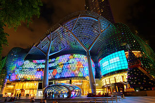
Orchard Road, often known colloquially as simply Orchard, is a major 2.5 km (1.6 mi)-long road in the Central Area of Singapore. A famous tourist attraction, it is an upscale shopping area, with numerous internationally renowned department stores, shopping malls, restaurants, and coffeehouses located in its vicinity. It is a popular hotspot in Singapore, especially at night, attracting trendy urban youth.
Dhoby Ghaut MRT station is an underground Mass Rapid Transit (MRT) interchange station on the North South, North East and Circle lines in Singapore. Located beneath the eastern end of Orchard Road shopping belt in Dhoby Ghaut, Museum Planning Area, the station is integrated with the commercial development The Atrium@Orchard. The station is near landmarks such as The Istana, the MacDonald House, Plaza Singapura and Dhoby Ghaut Green.
Clarke Quay MRT station is an underground Mass Rapid Transit (MRT) station on the North East line (NEL) in Singapore. Situated along Eu Tong Sen Street, near the junction of Merchant Road and North Canal Road, it is at the south of the Singapore River underneath The Central. The station serves Clarke Quay and Boat Quay, as well as other landmarks such as Hong Lim Park, The Riverwalk and the Swissotel Merchant Court.
The Singapore River is a river that flows parallel to Alexandra Road and feeds into the Marina Reservoir in the southern part of Singapore. The immediate upper watershed of the Singapore River is known as the Singapore River Planning Area, although the western part of the watershed is classified under the River Valley planning area.
Marina Bay is a bay located in the Central Area of Singapore, surrounded by the perimeter of four other planning areas, the Downtown Core, Marina East, Marina South and Straits View. The area surrounding the bay itself, also called Marina Bay, is a 360 hectare extension to the adjacent Central Business District. It is also the new downtown of Singapore, built on Singapore's reclaimed land.
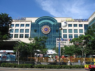
Dhoby Ghaut is a place in Singapore that often refers to the MRT station of the same name, which is a major interchange station on Singapore's Mass Rapid Transit network connecting the North-South Line, North East Line, and the Circle Line. As a place, Dhoby Ghaut lies along the eastern end of Orchard Road. There is a shopping mall above the MRT station called Plaza Singapura.
Somerset MRT station is an underground Mass Rapid Transit (MRT) station on the North–South Line in Orchard, Singapore. It is one of the three stations located along the popular shopping belt, Orchard Road.
Promenade MRT station is an underground Mass Rapid Transit (MRT) interchange station on the Downtown (DTL) and Circle (CCL) lines in Downtown Core, Singapore. Located underneath Temasek Avenue and adjacent to Millenia Tower, the station serves several key attractions and locations such as Suntec City and the Marina Promenade, which the station is named after. The station is at the junction of the Dhoby Ghaut and Marina Bay branches of the CCL.
Bras Basah MRT station is an underground Mass Rapid Transit (MRT) station on the Circle line (CCL) located in the Museum planning area, Singapore. It is underneath Bras Basah Road, bordering Waterloo Street and Queen Street. Located next to the Singapore Management University (SMU), this station is in proximity to the National Museum of Singapore, the Singapore Art Museum, Peranakan Museum and School of the Arts, Singapore. The station is connected to the nearby Bencoolen station on the Downtown line (DTL) via an unpaid link.
Esplanade MRT station is an underground Mass Rapid Transit (MRT) station on the Circle Line (CCL) in Singapore. Situated in the Downtown Core, it is at the junction of Bras Basah Road, Raffles Boulevard and Nicoll Highway. As the name suggests, the station serves the Esplanade performing arts centre, alongside various developments such as War Memorial Park, Suntec City Mall and the Suntec Singapore Convention and Exhibition Centre. Esplanade station is linked to the nearby City Hall station via CityLink Mall, an underground retail development.
This article shows the notable future developments in Singapore. Most of them are currently under construction with most to be completed within the next five years.
Waterloo Street is a two-way street in downtown Singapore stretching from Rochor Road to Bras Basah Road. It passes through the planning areas of Rochor and Museum Planning Area.
Bras Basah Road is a one-way road in Singapore in the planning areas of Museum and Downtown Core. The road starts at the junction of Orchard Road and Handy Road, at the ERP gantry towards the Central Business District, and ends at the junction with Nicoll Highway, beyond which it becomes Raffles Boulevard. Several landmarks including Fairmont Singapore, Raffles Hotel, Singapore Art Museum, Cathedral of the Good Shepherd and the Singapore Management University are located along the road. A MRT station with the same name, Bras Basah MRT station, is on the Circle Line.
Queen Street is one of the oldest streets in Singapore and once had a very strong Eurasian presence. Beginning at Arab Street, Queen Street forms major junctions with Ophir Road, Rochor Road, Middle Road and Bras Basah Road before ending at the junction of Stamford Road.
Fort Canning Tunnel, abbreviated as FCT, is a vehicular tunnel in the Central Area of Singapore.
The Old National Library Building was a historical library building at Stamford Road in the Museum Planning Area of Singapore. Originally completed in 1960, the library building was a national icon for many Singaporeans. Despite a huge groundswell of public dissent, the library was closed on 31 March 2004, and was demolished in July that year to make way for the construction of the Fort Canning Tunnel to ease road traffic to the city. The controversy surrounding the building's demise has been credited for sparking greater awareness of local cultural roots and an unprecedented wave in favour of heritage conservation among Singaporeans.
Kaplan Singapore is a for-profit private education institution headquartered in Singapore with other campuses in Hong Kong, Taiwan, and the People's Republic of China. It was known as the Asia Pacific Management Institute (APMI) before it was acquired by Kaplan Inc., a subsidiary of the Graham Holdings Company, in May 2005.
Sri Sivan Temple is a Hindu temple in Singapore for the god Shiva. The temple was originally located in Potong Pasir from where it was moved three more times before finally coming to the present location, adjacent to Foo Hai Ch'an Buddhist Monastery, in front of Paya Lebar MRT station exit C at Geylang East Avenue 2.
Bencoolen MRT station is an underground Mass Rapid Transit (MRT) station on the Downtown Line (DTL) in Singapore. Located under Bencoolen Street, the station serves primarily the Nanyang Academy of Fine Arts (NAFA), Singapore Management University and surrounding developments. At 43 metres (141 ft) below street level, Bencoolen is the deepest station in Singapore.
Bras Basah is a district located in the Museum Planning Area of the Central Area of Singapore. Bras Basah means "wet rice" in Malay – beras means harvested rice with husk removed, and basah means wet.