Hougang

Last updated

Hougang
Others transcription(s)
   Chinese 后港(Simplified)
後港(Traditional)
Hòugǎng(Pinyin)
Aū-káng(Hokkien POJ)
   Malay Hougang
   Tamil ஹவ்காங்
Havkāṅ(Transliteration)
Hougang Central, Oct 06.JPG
Kovan HDB flats.JPG
Photo Journal (set) - Typical Village Kampung house (9721908363).jpg
Hougang Avenue 4 2, Nov 06.JPG
Institute of Mental Health 7, Nov 06.JPG
Punggol Park, panorama, Nov 06.jpg
From top left to right: Hougang Central, Aerial view of Kovan, Kampong Lorong Buangkok, Flats along Hougang Avenue 4, Heritage Garden of the Institute of Mental Health, Panoramic view of Punggol Park
Hougang location.svg
Location of Hougang in Singapore
Singapore location map (main island).svg
Red pog.svg
Hougang
Location of Hougang within Singapore
Coordinates: 01°22′17″N103°53′33″E / 1.37139°N 103.89250°E / 1.37139; 103.89250
CountryFlag of Singapore.svg  Singapore
Region North-East Region
CDCs
Town councils
  • Ang Mo Kio Town Council
  • Aljunied-Hougang Town Council
  • Marine Parade Town Council
Constituencies
Government
  MayorsCentral Singapore CDC

North East CDC

South East CDC


  Members of ParliamentAljunied GRC

Ang Mo Kio GRC

Hougang SMC

Marine Parade GRC

Area
  Total13.93 km2 (5.38 sq mi)
  Residential3.67 km2 (1.42 sq mi)
Population
 (2019) [1] [3] [4]
  Total226,240
  Density16,000/km2 (42,000/sq mi)
Postal district
19
Dwelling units51,646
Projected ultimate72,000

Hougang or Aukang is a planning area and mature residential town located in the North-East Region of Singapore. The town is the most populous in the region, being home to 247,528 residents as of 2018. [5] Hougang planning area is bordered by Sengkang to the north, Geylang and Serangoon to the south, Bedok to the southeast, Toa Payoh to the southwest, Paya Lebar to the east, Ang Mo Kio to the west and Bishan to the southwest.

Contents

Geography

Subzones

Hougang is separated into 10 subzones, Hougang East, Defu Industrial Park, Tai Seng, Lorong Halus, Kangkar, Hougang West, Trafalgar, Lorong Ah Soo, Kovan and Hougang Central. [6]

Etymology and history

Hougang is the pinyin spelling of Aū-káng, a Hokkien and Teochew name meaning "river's end", as Hougang is located upstream or at the back of Sungei Serangoon. In the past, the name connoted the area stretching from the fifth milestone junction of Upper Serangoon Road and Upper Paya Lebar Road/Boundary Road to the seventh and a half milestone junction of Upper Serangoon Road and Punggol Road. The area just beyond the seventh milestone along Punggol Road was formerly considered part of Punggol but is now within Hougang Town and that section of Punggol Road is now Hougang Avenue 8, with Punggol Road starting further north. [7]

Pig farming was carried out in Punggol, including the area of Punggol that is now part of Hougang Town. The last of these pig farmers were relocated by the late-1990s to flats built in Hougang. Today, Hougang is an HDB new town with over 40,000 housing units interspersed with pockets of private residential areas.

There was also a fishing port at the end of Upper Serangoon Road beyond the seventh milestone.

At Hougang Street 21, there was a well that is still identified as the tua jia kha (大井跤) well structure. This well identified the Teochew village of tua jia kha which means the "foot of a big well". In the past, the village was a popular place for food, street wayangs, itinerant Chinese medicine men and story tellers spinning yarns.

The development of Hougang commenced in 1977 with the construction of Tampines Way. Further construction work was subsequently completed in Neighbourhoods 1 – 3 by 1983, and later Neighbourhoods 4 – 7 by 1992. Neighbourhood 8 is the town centre of Hougang and construction was completed in 1994. Neighbourhood 9 is the most recent with a completion date in 2000.

In 2015, a project named Hougang Capeview, a Build-To-Order project at Upper Serangoon Road, became the first public housing project to receive the CONQUAS Star, an accolade administered by the Building and Construction Authority. Hougang Capeview, which comprises 781 residential units in six blocks at Upper Serangoon Road, received a Construction Quality Assessment System (CONQUAS) score of more than 95, above the national average of 88.2. The CONQUAS score is BCA's measure of construction quality across Singapore. [8]

Shopping

Hougang has 8 shopping malls which are

Transport

Bus Interchange

Hougang Central Bus Interchange

Hougang Central Bus Interchange is a bus interchange serving the town of Hougang. It is located directly above Hougang MRT station. By 2030, Hougang Central Bus Interchange will be modernised to accommodate the Cross Island Line section, in addition to becoming an Integrated Transport Hub.

Bus Depots

Hougang Bus Depot

Hougang Bus Depot is an SBS Transit West District bus depot located in Hougang, Singapore. As of November 2014, the total fleet is 600 buses. Hougang Bus Depot started operations in 1983 when the north-east which is Hougang and Serangoon was developed and previously, all operations had been on Ang Mo Kio Bus Depot and Bedok Bus Depot respectively.

Mass Rapid Transit stations

Hougang MRT station

Hougang MRT station is an underground Mass Rapid Transit (MRT) station on the North East line and Cross Island line in the Hougang planning area in Singapore. Located within the Hougang Town Centre, the station is directly connected to Hougang Central Bus Interchange. This station will become an interchange station along the Cross Island line when Stage 1 of the Cross Island line opens in 2030.

Kovan MRT station

Kovan MRT station is an underground Mass Rapid Transit (MRT) station on the North East line in the Hougang planning area. With the opening of Kovan station, the former Hougang South Bus Interchange subsequently ceased operations in February 2004 and its services were transferred to Hougang Central Bus Interchange located next to Hougang MRT station.

Tai Seng MRT station

Tai Seng MRT station is an underground Mass Rapid Transit (MRT) station on the Circle line, situated on the boundary of Hougang planning area. Located along Upper Paya Lebar Road, Tai Seng station was named after and primarily serves the industrial clusters at Tai Seng, which in turn means 'big accomplishment' in Chinese. The name was first used on a rubber factory constructed in the area in 1917.

Defu MRT station

Defu MRT station is a future underground Mass Rapid Transit station on the Cross Island MRT line in Hougang planning area, Singapore. It will serve the Defu Industrial Park.

Serangoon North MRT station

Serangoon North MRT station is a future underground Mass Rapid Transit station on the Cross Island MRT line located on the boundary of Hougang planning area in Singapore.

Mass Rapid Transit Depots

Kim Chuan Depot

Kim Chuan Depot is a train depot for the Mass Rapid Transit system in Singapore. The depot is constructed fully underground and provides maintenance, stabling and operational facilities for the Circle Line. It is located in Hougang, along Upper Paya Lebar Road, and is accessible via Kim Chuan Road. It used to be the first depot in Singapore to serve two independently operated MRT lines, until the adjacent Tai Seng Facility Building became operational with the revenue operation of the Downtown Line Stage 3 on 21 October 2017.

Tai Seng Facility Building

Tai Seng Facility Building, abbreviated as TSFB, (or Tai Seng) is an underground train depot for the Mass Rapid Transit system in Singapore. The depot is constructed towards the east of Kim Chuan Depot and will provide maintenance, stabling and operational facilities for the Downtown Line. It is located in Hougang along Bartley Road East. It is accessible via a surface building located along Bartley Road East. The depot is approximately 52 metres wide, 295 metres long and 20 metres deep. It is connected to Kim Chuan Depot and has underground access for trains to run between both facilities, allowing Downtown Line trains to be stabled in the Tai Seng Facility Building, and able to access its remote tracks. It is used in tandem with Kim Chuan Depot for the operations of the Downtown Line.

Road networks

Two of the oldest main roads: Upper Serangoon Road and Punggol Road run through Hougang since the town's beginning. The town is also linked to other towns by Yio Chu Kang Road in the West, Tampines Road in the East, Upper Paya Lebar Road to the south-East, Buangkok Drive & Buangkok Green in the North.

Other roads in Hougang New Town links the town to bigger roads, most importantly Avenue 2, 3 which links the town from East and West.

Amenities

Hougang Mall Shopping Centre Hougang Mall, Nov 05.JPG
Hougang Mall Shopping Centre
Another view of Hougang Mall Shopping Centre, before renovation Singapore hougang mall 2002.jpg
Another view of Hougang Mall Shopping Centre, before renovation

Most of Hougang's commercial activity is centred on a few shopping malls such as Hougang Mall, Kang Kar Mall, Heartland Mall, Upper Serangoon Shopping Centre and Hougang 1 (Formerly known as Hougang Point, and opened in End 1999).

Similar to most other residential towns in Singapore, Hougang was designed to be a partially self-sufficient with enough amenities to minimize the number of residents commuting to the Central Area. Facilities include Hougang Sports Hall, an indoor sports complex operated by Sport Singapore which runs ClubFITT membership and sports programmes, Hougang stadium home to S.League club Hougang United, an aquatics centre, a number of parks such as Punggol Park, along with many wet markets and hawker centres.

One of the more prominent landmarks in Hougang is the Buangkok Green Medical Park, which houses several medical facilities including the Institute of Mental Health (IMH) and Singapore Leprosy Relief Association (SILRA).

The Hougang Central Bus Interchange serves Hougang Town with a range of bus services going to other parts of the island. It is located in Hougang Central, near Hougang Mall and it has an underground link to Hougang MRT station. This bus interchange was officially opened on 17 December 1994 by former cabinet minister Goh Chee Wee, who was then Senior Minister of State for Communications, Trade and Industry to serve all buses around the Hougang Area. Its sister bus interchange, Hougang South Bus Interchange (that is near to Kovan MRT station) ceased operations in 2004 and was converted to Kovan Hub.

Two even older bus terminals operated in Hougang before the construction of the Hougang Central and Hougang South Bus Interchanges. One was at the end of Upper Serangoon Road in Kangkar Village, which was replaced by Hougang Central, while the other was at the sixth and a half milestone of Upper Serangoon Road, which was replaced by Hougang South. [9]

Highlights

Houses in Hougang Singapore Hougang 2002.jpg
Houses in Hougang

A distinctive feature of Hougang lies in the large semi-circular balconies which occur in many Housing and Development Board public housing flats in the area. This feature is not as prevalent in public housing outside Hougang. The latest addition of new Condominium will be Florence Residences in 2019.

Politics

The political representation of Hougang was split into four different constituencies as of the 2020 elections, three of which were Group Representation Constituencies (GRC) (Aljunied, Ang Mo Kio, and Marine Parade), and one Single Member Constituency (SMC) bearing the same name, the Hougang Single Member Constituency. Currently, Aljunied and Hougang wards are managed by the opposition Workers' Party (WP), while Ang Mo Kio and Marine Parade are managed by the ruling People's Action Party (PAP). Previously, Hougang was administered by five now-defunct wards (Jalan Kayu, Paya Lebar, Punggol, Serangoon Gardens and Upper Serangoon), before it redistricted into GRCs, notably Cheng San GRC (also defunct since 2001).

Hougang SMC

The area covering Hougang Avenues 2, 5, 7 and a small portion of Hougang Central, falls under the namesake Hougang SMC, where it was carved out from Punggol ward ahead of the 1988 elections. The first Member of Parliament (MP) of the ward was PAP's Tang Guan Seng, until it had been captured by former WP secretary-general Low Thia Khiang in 1991. Low left the ward to contest (and later elect himself in) Aljunied GRC ahead of the 2011 elections, and was replaced by Yaw Shin Leong, another WP candidate who previously contested Ang Mo Kio GRC in the 2006 elections. [10] Yaw remained as an MP until his expulsion from the party's CEC and resigned his seat in February 2012 over an extramarital affair. Png Eng Huat, a candidate whose part of the WP team contested East Coast GRC in the 2011 elections, had since represented this ward after winning his by-election in May 2012 until he stepped down ahead of the 2020 election. Dennis Tan, who previously contested Fengshan SMC in the 2015 elections (now part of East Coast GRC) and become a Non-constituency Member of Parliament (NCMP), has replaced outgoing Png following the election.

Aljunied GRC

The area covering south of Hougang Avenues 6, 8, 10, as well as Punggol Park, Defu Industrial Park and the subregion of Kovan, falls under Aljunied GRC. The western portions of Hougang, previously being Serangoon Gardens division, were split into two divisions with Jalan Kayu in the Ang Mo Kio GRC and Serangoon in the Aljunied GRC. The area was previously belong to the short-lived Thomson GRC in 1991.

The GRC was not contested in 2001 with the WP being disqualified due to incomplete applications, but in the 2006 elections, the WP were able to pose a strong challenge for this ward, with the members consist of WP's chairwoman Sylvia Lim and former members Goh Meng Seng and James Gomez. [11]

The GRC was managed by the PAP which members include Cynthia Phua and George Yeo, until it became the first opposition held GRC since the creation of the GRC in Singapore after the 2011 Singaporean general election being taken over by Low Thia Khiang's WP team. The WP continued to hold the GRC in the 2015 and 2020 Singaporean general elections with Leon Perera and Gerald Giam replacing Low and Chen Show Mao.

Ang Mo Kio GRC

The north-western portions of Hougang (Avenues 4, 8 and 9, and Street 91), which includes Hougang Stadium and Regentville Condo, falls under the Ang Mo Kio-Hougang division of the Ang Mo Kio GRC. Its MP is Darryl David, who replaces former MP Yeo Guat Kwang after the 2015 elections. Prior to the 2011 elections, the ward was a part of Aljunied GRC (under the name of Aljunied-Hougang), where Yeo was then the MP.

The northern portions of Hougang (north of Avenues 6, 8 and Street 51) also falls under the Ang Mo Kio-Hougang division, part of Ang Mo Kio GRC. It previously belonged to Pasir Ris-Punggol GRC (under the name of Punggol South) until it was carved out in 2015. After the 2020 elections, the portion was merged with the Ang Mo Kio-Hougang division.

The western portions of Hougang, previously being Serangoon Gardens division, were split into two divisions with Jalan Kayu in the Ang Mo Kio GRC and Serangoon in the Aljunied GRC.

Marine Parade GRC

The southernmost portion of Hougang, Tai Seng, was under the Geylang Serai division of Marine Parade GRC, where Mohd Fahmi Aliman represented the ward. Marine Parade was also contested by WP during the 2015 and 2020 elections.

Education

Hougang has a total of nine primary schools, eight secondary schools and a single international school as of 2024.

Primary schools

Secondary schools

Other schools

Hougang Sports Hall Hougang Sports Hall .jpg
Hougang Sports Hall

See also

Related Research Articles

<span class="mw-page-title-main">Ang Mo Kio</span> Planning Area and HDB Town in Singapore

Ang Mo Kio is a planning area and residential town situated in the North-East region of Singapore. Located approximately 11 km (6.8 mi) north of the Downtown Core district, Ang Mo Kio is the 3rd most populated planning area in the North-East region and ranks 8th in terms of population in the country overall. The planning area is located at the south-western corner of the North-East region, bordered by the planning areas of Yishun to the north, Sengkang to the north-east, Serangoon to the east, Bishan to the south and the Central Water Catchment to the west.

<span class="mw-page-title-main">Serangoon</span> Planning Area and HDB Town in North-East Region ----, Singapore

Serangoon is a planning area and residential town located in the North-East Region of Singapore.

<span class="mw-page-title-main">Bedok</span> Planning Area and HDB Town in East Region, Singapore

Bedok is a planning area and residential town located in the geographical region of Tanah Merah along the south-eastern coast of the East Region of Singapore. Bedok is bounded by five other planning areas: Paya Lebar to the north, Hougang to the northwest, Tampines to the northeast and east, Geylang to the west and Marine Parade to the southwest. It also shares a maritime boundary with the Singapore Strait to the south and southeast.

<span class="mw-page-title-main">Kovan MRT station</span> Mass Rapid Transit station in Singapore

Kovan MRT station is an underground Mass Rapid Transit (MRT) station on the North East line (NEL) in Hougang, Singapore. Located underneath Upper Serangoon Road, the station serves the retail development of Heartland Mall and surrounding public and private residences.

The Ang Mo Kio Police Division is one of the seven land divisions of the Singapore Police Force. It was first established in 1965. It was previously located in Paya Lebar. In 1987, the division HQ moved to its present location to better serve the public and meet its operational needs. Ang Mo Kio Division serves a residential population of over 1.1 million residents. Ang Mo Kio Division’s area of coverage includes mature housing estates such as Ang Mo Kio, Hougang and Serangoon. It also oversees young but rapidly-developing residential estates like Sengkang and Punggol.

<span class="mw-page-title-main">Fernvale, Singapore</span> Place in Singapore

Fernvale is a neighbourhood of Sengkang New Town in Singapore. It is located between Sungei Punggol and the proposed Sengkang West Industrial Estate. The house numbers of the public apartment blocks in Fernvale begin with the number '4' (4xx). Fernvale is the newest neighbourhood in Sengkang Town to be completed by the Housing and Development Board (HDB). Seletar Mall, a new shopping amenity which houses Sengkang's first cineplex, is located within this neighbourhood. In 2017, a proposed community facility to be located next to Seletar Mall was announced, which houses a community club, childcare centre, hawker centre and wet market. The community facility which was slated to be ready by the second half of 2020, had stopped construction in April 2020 due to the COVID-19 measures set by the government. Construction of the facility has since continued in the second half of 2020 and was completed in 2022.

<span class="mw-page-title-main">Sengkang</span> Planning Area and HDB Town in North-East Region ----, Singapore

Sengkang is a planning area and residential town located in the North-East Region of Singapore. The town is the second most populous in the region, being home to 249,370 residents in 2020. Sengkang shares boundaries with Seletar and Punggol in the north, Pasir Ris and Paya Lebar in the east, Hougang and Serangoon to the south, as well as Yishun and Ang Mo Kio to the west.

<span class="mw-page-title-main">Buangkok</span> Place in Singapore

Buangkok is a neighbourhood located in north eastern Singapore. Whilst its boundaries are vague, the neighbourhood is roughly spread across the Trafalgar and Compassvale subzones of the Hougang and Sengkang Planning Areas respectively, as designated by the URA.

<span class="mw-page-title-main">Aljunied Group Representation Constituency</span> Electoral constituency in Singapore

The Aljunied Group Representation Constituency is a five-member group representation constituency (GRC) in the north-eastern and eastern region of Singapore. It consists of a large part of Hougang, Paya Lebar, Serangoon Gardens, the southern half of Serangoon North as well as a portion of Bedok and a very small section of Tampines managed by the Aljuined-Hougang Town Council. The GRC consists of five divisions: Eunos, Bedok Reservoir-Punggol, Kaki Bukit, Serangoon and Paya Lebar. The current members of parliament are Gerald Giam, Pritam Singh, Muhamad Faisal Manap and Sylvia Lim from the Worker's Party (WP).

<span class="mw-page-title-main">Hougang Single Member Constituency</span> Electoral division in Singapore

The Hougang Single Member Constituency is a single member constituency (SMC) located in the north-eastern area of Singapore. It is managed by Aljunied-Hougang Town Council. The current Member of Parliament is Dennis Tan Lip Fong of the Workers' Party (WP).

Cheng San Group Representation Constituency was a Group Representation Constituency (GRC) in the North-eastern region in Singapore. The GRC consisted of the eastern part of Ang Mo Kio, Jalan Kayu, Seletar Hills, part of Serangoon North, a large part of Hougang, Buangkok, and the whole of Sengkang New Town and Punggol New Town.

<span class="mw-page-title-main">North-East Region, Singapore</span> Region in Singapore

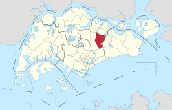
The North-East Region of Singapore is one of the five regions in the country. The region is the most densely populated and has the highest population among the five, with Sengkang being its most populous town as of 2020 and Seletar as the regional centre. Comprising 13,810 hectares, it includes seven planning areas and is largely a residential region with 217,120 homes. Housing largely consists of high-density HDB public housing estates, however private housing is also present in the region. As its name implies, it is located in the north-eastern part of Singapore.

<span class="mw-page-title-main">Kovan, Singapore</span> Place in Singapore

Kovan is a neighbourhood located within the town of Hougang, in Singapore. The neighbourhood today largely consists of private housing properties, where majority of the residents live in terrace homes, semi-detached houses and bungalows.

Serangoon North Village and Estate is a cluster of HDB apartment flats located north of Serangoon Central separated by Serangoon Gardens to the west and private housing estates to the east with Yio Chu Kang Road connecting the two areas. It is a subzone of the neighbouring area Hougang. It is sandwiched between Ang Mo Kio to the west, Serangoon Gardens to the southwest, and Hougang to the east.

<span class="mw-page-title-main">North East Community Development Council</span>

The North East Community Development Council is one of five Community Development Councils (CDCs) set up across the Republic of Singapore to aid in local administration of governmental policies and schemes. They are funded in part by the government although they are free to engage in fund-raising activities.

Joo Seng is a subzone located in Toa Payoh in the Central Region of Singapore. It gets its name from Bartley Road, which stretches from the end of Braddel Road to Upper Paya Lebar Road, as part of the Outer Ring Road System. There are some condominiums and houses in the area. It is also where the Gurkha Contingent is based. There are many Gurkhas and their families living there in private flats.

<span class="mw-page-title-main">Cheng San Public Library</span> Public library in Singapore

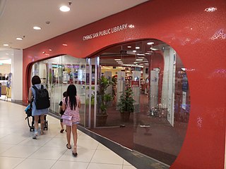
Cheng San Public Library is a public library in Hougang, located inside Hougang Mall. It is the third library of the National Library Board to be located in a mall and the first to acquire and display works by local artists. It is near Hougang MRT station and Hougang Central Bus Interchange.

References

  1. 1 2 "Bukit Merah (Planning Area, Singapore) – Population Statistics, Charts, Map and Location". citypopulation.de. Archived from the original on 23 July 2020. Retrieved 20 February 2016.
  2. HDB Key Statistics FY 2014/2015 Archived 4 March 2016 at the Wayback Machine
  3. "Land Area and Dwelling Units by Town". Data Singapore. 2016. Archived from the original on 12 June 2019. Retrieved 26 January 2018.
  4. "Statistics Singapore – Geographic Distribution – 2018 Latest Data". Archived from the original on 30 January 2016. Retrieved 11 February 2019.
  5. "Hougang (Planning Area, Singapore) – Population Statistics and Location in Maps and Charts". City Population (with data from Singapore Department of Statistics). Archived from the original on 10 August 2019. Retrieved 15 August 2016.
  6. "STATISTICS SINGAPORE – Map of Planning Areas/Subzones in Singapore – Population 2017" (PDF). Archived (PDF) from the original on 29 March 2019. Retrieved 13 April 2022.
  7. "OneMap, see Historical Maps from 1970s or earlier". Archived from the original on 18 May 2015. Retrieved 13 May 2015.
  8. "Hougang BTO development gets top award for construction quality – Channel NewsAsia". Channel NewsAsia. Archived from the original on 22 September 2015.
  9. List of former bus stations in Singapore
  10. "E: WP takes Hougang, PAP wins 11 SMCs". Channel NewsAsia. Archived from the original on 22 October 2012. Retrieved 8 June 2012.
  11. Aljunied Group Representation Constituency

Sources